(UPDATED at 11 p.m. MDT, June 29, 2014)

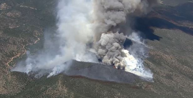
The Eightmile Fire was less active on Saturday than it was on Friday when it grew from about an acre to almost 500 acres. It started on Monday from a lightning strike and is being managed, rather than totally suppressed, as a confine/contain fire. Early Sunday morning a mapping flight determined that it had grown by about 29 acres over the last 26 hours, to 524 acres. The Incident Management Team is calling it 25 percent contained.
The pre-evacuation notice for the 16 residence in Red Rocks subdivision remains in effect. On Saturday aircraft dropped 140,253 gallons of water and 71,315 gallons of retardant. Firefighters are constructing fireline in one Division on the fire, and are “continuing to seek opportunities and scout areas for tactical options” on the other three.
While they are deciding what to do, the area is under a Red Flag Warning from Sunday at noon until 7 p.m. for strong winds, low relative humidity, and dry fuels. The winds should be out of the west at 10 to 20 mph with the relative humidity at 10 percent. Monday will be a little cooler, less breezy, with a 20 percent chance of rain. **** (UPDATED at 8:48 a.m. MDT, June 28, 2014)

The Eightmile Fire 7 miles northeast of Cañon City, Colorado was mapped Friday night at 496 acres. It started from a lighting strike on Monday, June 23 and on Friday morning was still only about one acre in size. The fire is just east of Phantom Canyon Road (67), east of Eightmile Creek, and six miles west of Highway 115. It is burning on Bureau of Land Management land primarily in a Wilderness Study Area. The BLM is not totally suppressing the fire, but instead is employing a Confine/Contain strategy. Friday night the BLM issued this evacuation advisory:
The Fremont County Sheriff, in cooperation with Eightmile Fire managers, has issued a pre-evacuation notice for 16 residences in the Red Rocks Subdivision. Specifically, the residents on the west side of County Road 132 from mile marker 5 to mile marker 9.5. Residents are encouraged to be prepared to evacuate should the need arise. Again, this is a pre-evacuation notice only.

Rocky Mountain Incident Management Team B with Incident Commander Dan Dallas assumed command of the Eightmile Fire at 6 a.m. MDT, Saturday, June 28. There will be a public meeting at 7 p.m. Saturday at Cañon City High school, 1313 College Avenue. The weather forecast for the fire area calls for southwest winds at 6 to 8 mph, relative humidity in the high teens, temperature in the high 70s, and no chance of rain. On Sunday the winds will be stronger, out of the southwest at 11 to 16 mph. **** (Originally published at 6:41 p.m. MDT, June 27, 2014)

A fire that started on Monday, June 23 was still about an acre in size Friday morning. According to the Bureau of Land Management, by two p.m. the Eightmile Fire had grown to 700 acres. On Tuesday firefighters hiked in to it, but later had to leave due to a thunderstorm in the area. On Wednesday it was still only 1/4 acre 7 miles northeast of Cañon City, and 31 miles northwest of Pueblo, Colorado. The BLM says it is being managed with a Confine/Contain strategy. There are currently 35 resources assigned to the fire. Four 20-person Hotshot crews and a Type 2 Incident Management Team have been ordered. A Type 1 helitanker is committed and two Single Engine Air Tankers and two heavy airtankers have been ordered. The BLM said crews will continue construction of the indirect fire line in strategic locations.
A lot of smoke still rising off of the #EightMileFire pic.twitter.com/UuLeQxXoqW — Michael Ciaglo (@MichaelCiaglo) June 27, 2014
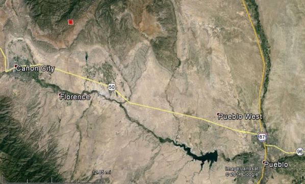
The map below shows the location of the fire (the red square) as it was detected by a satellite at 12:30 p.m. MDT, June 27, 2014.

KOAA has some good video of the fire. Be sure and turn your sound down before you go there.

I find the maps that I can read the scale on much more helpful. Can you measure the distance from the fire to Cheyenne Mountain State Park or norad cheyenne mountain for me please? Thanks in advance for giving it a try.
Bruce, early this morning the fire was 19 miles from Cheyenne Mountain State Park.
Thanks! We went to the car show in Pueblo today, and man it was sure windy! I’m looking forward to finding out how much closer it is to Cheyenne Mountain State Park in the morning!
Thanks again!
Confine or contain, pick one. Both does not make sense.
Looks like another death trap.
It sure can happen easy in that country. Steep, Boxy, limited ingress/egress, etc.
I think the original “35 firefighters” vs “35 resources” should be looked into further. Most sources in the media were quoting BLM press releases saying “35 firefighters” were on scene fighting the fire with additional resources on order.
The BLM press release said “35 resources”.
Initial press releases said 35 firefighters when the fire grew from 60 acres.
You have to deploy resources resourcefully to protect the resource.