UPDATED at 6:35 p.m. PDT November 2, 2019
The Ventura County Fire Department announced at 2:39 p.m. Saturday that all evacuation orders on the Maria Fire have been lifted.
More accurate mapping determined that the fire has burned 9,412 acres, which is a decrease from the 10,720-acre figure released earlier.
The number of structures burned has remained at three. That has not been broken down as to the type, such as outbuildings, homes, or commercial structures.
Saturday morning there were still 1,200 personnel assigned to the fire.
Crews from many different agencies are working hard to make areas safe for the public to return to. Fire weakens infrastructure and creates hazards that need to be addressed. Check out this video for more. pic.twitter.com/A2VdXvB9TF
— VCFD PIO (@VCFD_PIO) November 2, 2019
We spotted the fire turning crosswind after departing SZP, this is at 6:16:29 pm, we texted people on the ground to call it in, as well as calling it in to PT Mugu approach over the radio. pic.twitter.com/wuRA56Dy5D
— acloudaway (@acloudaway1) November 2, 2019
UPDATED at 7:37 a.m. PDT November 2, 2019
Friday afternoon the Maria Fire east of Ventura, California grew by another 2,000 acres on the west and north sides. The Ventura County Fire Department said a total of 10,720 acres have burned.
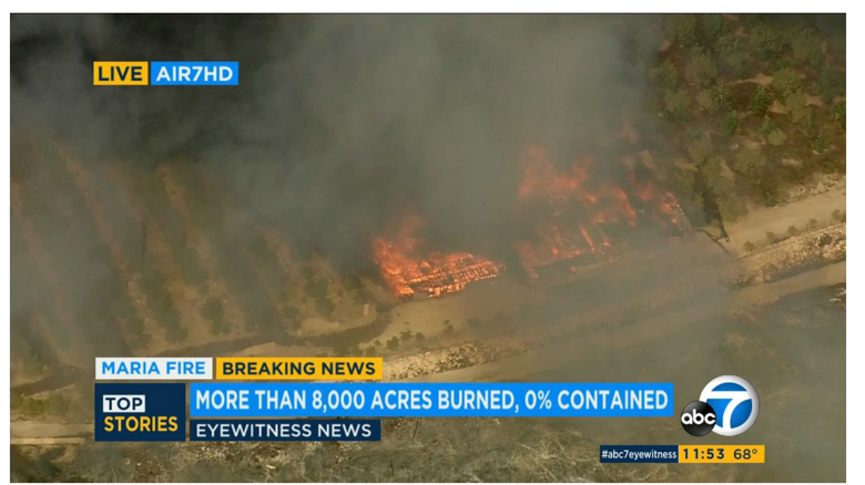
As the fire moved north into the Santa Clara river bottom on Friday live views from cameras on helicopters showed several structures burning, some of which appeared to be affiliated with ranching or farming. Horses freed by ranch hands were running from the fire.
The UPI reports that the fire, which started near mountaintop communication sites, may have been related to re-energized power lines.
Southern California Edison said that though it’s not sure what caused the Maria Fire, the company did re-energize its power lines in the vicinity about 13 minutes before it sparked. The company had previously cut off power to the area amid strong winds.
(Scroll down to see a tweet that has a photo of the fire shortly after it started.)
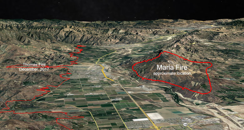
SCE power lines caused the huge fire across the valley from the Maria Fire, the Thomas Fire that in December, 2017 blackened 230,500 acres and destroyed 1,063 structures (see the map below). Two people were killed directly by the Thomas fire, one firefighter and a civilian, and 21 were killed later by flooding and mud flows off the vegetation-free mountains. Over 8,500 firefighters were mobilized to fight it, which is the largest mobilization of firefighters for combating any wildfire in California history. The cost of suppressing the fire was over $200 million.
Drones over the fire Friday at 3:19 a.m. and 4:05 a.m. shut down the water dropping activities of two night-flying helicopters, the LA Times reported. According to @VCscanner, Air Attack 51 reported one of the drones at about 3,000 feet, resulting in all firefighting aircraft having to shut down.
The Red Flag Warning has been extended through 6 p.m. Saturday due to very dry air with humidity levels from 2 to 8 percent, recovering only to 8 to 18 percent overnight. Daytime highs on Saturday and Sunday in the fire area are expected to be between 77 and 85 degrees. Northeast winds will persist through Saturday, with the Ventura County Mountains and Valleys experiencing 10-25 mph winds and gusts of 25-35 mph. Weaker but still present offshore winds will be present Saturday night through Sunday.

UPDATED at 12:15 p.m. PDT Nov. 1, 2019
The wind on the north side of the Maria Fire has shifted. Instead of coming from the northeast it is now from the east at 10 mph gusting to 20, which is pushing the fire toward the river bottom south of Santa Paula. Additional firefighting resources are being dispatched to deal with the increased threat to structures.
Video from television helicopters has showed structures burning.
The Ventura County Fire Department reported at 12:10 p.m. Friday that the fire had burned 8,700 acres.


7:25 a.m. PDT November 1, 2019
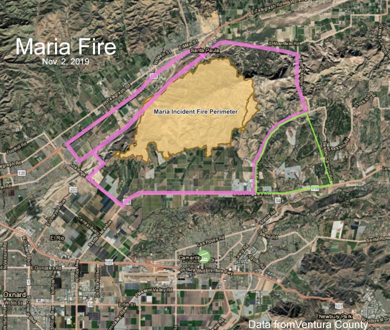
Thursday night a rapidly spreading fire south of Santa Paula, California was pushed six miles to the southwest by winds gusting at 25 mph. (see map above)
The Maria Fire was reported at 6:15 Thursday night near South Mountain and within eight hours was 4 miles east of Ventura and 2 miles north of Camarillo. The Ventura County Fire Department reported at 6:30 Friday morning that it had been mapped at 8,060 acres.
The County Sheriff’s office issued mandatory evacuation notices Thursday night affecting about 1,800 structures and 7,500 residents. NBC Los Angeles said two homes have burned.
Thursday night a weather station on South Mountain recorded sustained winds of 18 to 20 mph gusting out of the northeast at 25 to 30 while the relative humidity was extremely low, at 5 percent.
The Maria Fire is across the valley from the Thomas Fire that in December, 2017 blackened 230,500 acres and destroyed 1,063 structures.
“I want to assure you that this is not the Thomas Fire,” said Ventura County Assistant Fire Chief John McNeil. “Based on the location, it’s going to eventually run out of fuel … we’re looking at maybe 12,000 acres at the biggest footprint on this,” he said.
As you can see on the satellite map above, out ahead of the fire that was spread by winds out of the northeast are agricultural fields that would slow or stop the Maria Fire.
The photo below appears to have been taken shortly after the Maria Fire ignited.
#MariaFire Crews are responding to a brush fire on the top of South Mountain, just South of Santa Paula. pic.twitter.com/ZHeiyZ8xQX
— VCFD PIO (@VCFD_PIO) November 1, 2019
#MariaFire; Has grown to 8,060 acres. The winds have subsided a bit and the cold temperatures have reduced the fires ability to aggressively run down hill. Ground and air resources are strategically attacking the perimeter. pic.twitter.com/LWRjZDxsZW
— VCFD PIO (@VCFD_PIO) November 1, 2019
The #MariaFire exploded across South Mountain as these big rigs maneuvered past the flames https://t.co/fOGlpgVXbz pic.twitter.com/JkfLRhSwo3
— KTLA (@KTLA) November 1, 2019


It is very scary with all these fires going on in that area of Southern California. I had been there long time ago. One area was well-known for movie stars’ ranch with horses in huge lot and single level ranch house. I didn’t think the area was pretty, mostly just low hills, widely spread out, some trees and vegetation.
The KTLA news helicopter footage of the Maria fire so close to the (moving) trailered dozer ended without showing whether the operator backed-out as the second rig nearby had done. Anyone know how that played-out?
The transports with dozers pushed through, I believe KTLA has the footage on there Facebook.
Thanks! I found a couple of photos later today.