More evacuations ordered for Caldor Fire southwest of Lake Tahoe

149,000 acres have burned

9:36 a.m. PDT August 28, 2021

Caldor Fire map 11 p.m. August 27, 2021
Caldor Fire, mapped by a fixed wing flight at 11 p.m. August 27, 2021. The areas shaded dark red had intense heat during the mapping flight.

The Caldor Fire on Friday spread less than in previous days, but still grew by about 6,000 acres to bring the size up to 149,000 acres.

There was incremental movement on northeast side, less than half a mile, but the area where it spread most was on the west side. Late in the afternoon a wind shift pushed flames about 1.5 miles southwest along Camp Creek south of Sly Park Road, forcing firefighters to withdraw from the area. This was southeast of Pleasant Valley and northwest of Somerset. An aggressive attack from the air with helicopters and very large air tankers commenced, but visibility degraded by smoke limited their use, often having to loiter in orbit waiting for the smoke to clear.

To see all articles on Wildfire Today about the Caldor Fire, including the most recent, click HERE.

Inversions Saturday night slowed the spread, but with the relative humidity remaining mostly below 35 percent the down canyon winds from the east kept the fire active with spot fires occurring in the Camp Creek area. But the wind direction made it easier for firefighters on the east side to conduct burning operations.

Caldor Fire map west side 11 p.m. August 27 2021
Map of the west side of the Caldor Fire, mapped by a fixed wing flight at 11 p.m. August 27, 2021. The green line was the perimeter 27 hours earlier.

7:37 a.m. PDT August 27, 2021

Caldor Fire 3-D map
Northeast side of the Caldor Fire in 3-D, looking northeast. Mapped by a fixed wing aircraft at 8:11 p.m. PDT August 26, 2021.

Additional evacuations were ordered on the 143,000-acre Caldor Fire Thursday. The blaze was very active on the northeast side, and that continued into the night due to the humidity rising to only 22 to 28 percent. Short-range spotting produced numerous spot fires across control lines. The wind subsided after midnight and the spread of the fire slowed.

Firefighting aircraft were hampered Thursday with visibility degraded by smoke.

The growth was primarily to the northeast as the fire moves closer to the small communities along Highway 50. Unofficial distances from the fire were measured based on a mapping flight at 8:11 p.m. PDT August 26. This information should not be used for planning or making decisions about evacuation. Strawberry, 1.5 miles; the southern junction of Highways 50 and 89, 8 miles; Fallen Leaf Lake, 8 miles; Lake Tahoe shoreline, 11 miles.

For Friday firefighters expect the growth will continue in the northeastern areas but will be moderated by the arrival of light winds. Spot fires are likely to occur some distance from the fire’s edge and previously undetected sleepers caused by burning embers from earlier activity may emerge. In the evening the light winds will allow nighttime inversions to form.
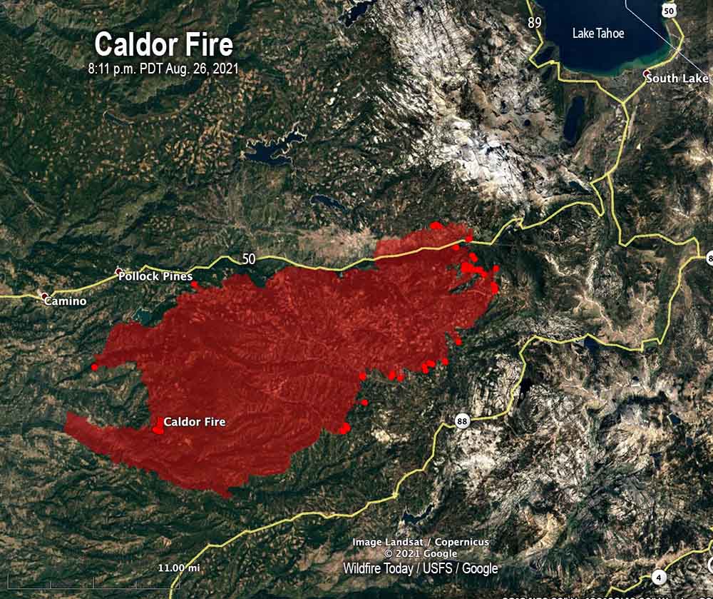
Caldor Fire map
Caldor Fire, mapped by a fixed wing aircraft at 8:11 p.m. PDT August 26, 2021.

The weather forecast for Friday at 6,000 feet is for 8 mph winds out of the northwest with humidity in the mid-teens and a high of 78 degrees. Saturday will be warmer with lower humidity and 8 mph hour winds out of the south and west.

The fire has destroyed 469 residences and 181 other structures; more than 18,000 are threatened. The El Dorado County Sheriff in collaboration with CAL FIRE has released a map displaying properties that have been inspected for any damage or that have been destroyed by the Caldor Fire.

Mandatory evacuations are in place for 33,723 residents as well as warnings that mandatory evacuations may occur for other areas in the future.  Evacuation notices are posted by the El Dorado County Sheriff’s office. Below is a screenshot from the Sheriff’s website, obtained at 7:11 a.m. PDT August 27, 2021. Go to their site for current information.
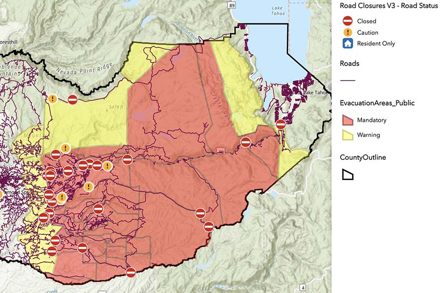
Caldor Fire evacuation map
Caldor Fire evacuation map, obtained from the El Dorado County Sheriff’s website at 7:11 a.m. PDT Aug 27, 2021.

Resources assigned to the fire Thursday evening included 250 fire engines, 63 water tenders, 25 helicopters, 82 hand crews, and 71 dozers for a total of 3,204 personnel.

In the two weeks it has been burning, the average daily suppression cost of the Caldor Fire is $3.4 million; about $24 an acre. And it is far from being over.

The number of residences destroyed in Dixie Fire increases to 690

Posted on Categories WildfireTags ,

139 commercial buildings have been destroyed

12:45 p.m. PDT August 26, 2021

Dixie Fire map
Dixie Fire map, northwest section. The fire was mapped by a fixed wing aircraft at 8 p.m. Aug. 25, 2021. The red areas had extreme heat during the flight.

The Dixie Fire near Susanville, California has burned 747,091 acres and has run up fire suppression costs of more than $365 million. At last count 690 residences and 139 commercial buildings had been destroyed. A map is available showing which structures have been surveyed for damages.

There are two areas on the fire that had large concentrations of heat when the fire was mapped Wednesday night. One was the northeast section south of Highway 44, 6 miles southeast of Old Station. After burning much of the east side of Lassen Volcanic National Park the fire ran an additional three miles north. During the 8 p.m. mapping flight Wednesday night it was a mile south of Highway 44. The fire is still very active in the center of the park and outside its northeast corner.

Dixie Fire map
Dixie Fire map, southeast section. The fire was mapped by a fixed wing aircraft at 8 p.m. Aug. 25, 2021. The red areas had extreme heat during the flight.

The other very active area on the Dixie fire is east of Taylorsville and around the Genesee Valley. Wednesday night hotshot crews continued to work the fire down off Mt. Jura to the valley bottom to secure Taylorsville. No spots have occurred. On Thursday resources will focus on holding this line. Crews have been actively engaged in structure protection in the Genesee Valley near Ward Creek and Little Grizzly Creek as the Peel Ridge spot fire backed down into the valley. They will continue this work Thursday.

(To see all articles on Wildfire Today about the Dixie Fire, including the most recent, click HERE.)

The Dixie Fire burned into the footprint of the 2019 Walker Fire, spreading for approximately a quarter of a mile inside, along 10 miles of Walker’s western perimeter.

On Thursday firefighters will construct direct and indirect line to secure fire lines in the Westwood area, which they expect will require a heavy resource presence.

Temperatures Thursday are expected to increase while winds from the north and northwest decrease to six mph out of the west-southwest. The relative humidity will be in the low 20s with very little cloud cover.

Dixie Fire vicinity map
Dixie Fire vicinity map, 8 p.m. Aug. 25, 2021.

Greenwood Fire burns nearly 26,000 acres in northeast Minnesota

Twenty miles northwest of Silver Bay

12:29 p.m. CDT August 26, 2021

Greenwood Fire, August 15, 2021 Minnesota
Greenwood Fire, August 15, 2021. US Forest Service photo.

The Greenwood Fire has burned nearly 26,000 acres in Northeast Minnesota in the 10 days since it started from a lightning strike August 15. The fire is 20 air miles northwest of Lake Superior and the community of Silver Bay.

The vegetation that is burning, brush and timber, has very low fuel moistures, similar to late fall conditions. The Energy Release Component which can help predict the intensity and rate of spread of a fire, is extremely high, between the 90th and 97th percentile.

Greenwood Fire
Greenwood Fire in northeast Minnesota, August 23, 2021.

On Wednesday the  fire was active in the southern portion. Firing operations were conducted along Highway 1 and the Jackpot Lake Road and along Highway 2 at the southwest end of the fire.

Greenwood Fire map Aug. 25, 2021

The priority Thursday is to hold and improve after Wednesday’s firing operations. With the support of air resources, engines, bulldozers, and other equipment crews will reduce the burnable natural fuels near homes and near the edge of the fire.

A total of 476 personnel are working on the fire, including cooperators and contractors.

The weather forecast for Thursday includes a 40 percent chance of rain in the afternoon which will be the beginning of a wet pattern that should persist until Sunday morning, bringing more than an inch of precipitation. This could mean photographs like these will not be possible for a while.

Greenwood Fire Minnesota
Greenwood Fire, defensive burn-out operation, August 22, 2021. InciWeb.

The Greenwood Fire and others were easily detected by the GOES-16 satellite:

Firefighters on Caldor Fire concentrating on dozers and firing operations

It has burned more than 136,000 acres 12 miles southwest of Lake Tahoe

7:51 a.m. PDT August 26, 2021

Map of the Caldor Fire 1223 a.m. August 26, 2021
Map of the Caldor Fire. The pink line was the perimeter mapped by a fixed wing aircraft at 12:23 a.m. PDT August 26, 2021. The blue line was the perimeter 50 hours earlier. The pink shaded areas had extreme heat during the mapping flight.

The northeast side of the 136,000-acre Caldor Fire 12 miles southwest of Lake Tahoe was active Wednesday night. The fire added about 10,000 acres over the last 24 hours. The spot fire north of Highway 50 has continued to spread east, growing to approximately 2,600 acres. The photo below was taken in that area.

To see all articles on Wildfire Today about the Caldor Fire, including the most recent, click HERE.

Caldor Fire, Wrights Lake Rd
Caldor Fire, Wrights Lake Road north of Hwy. 50, Aug. 25, 2021. CAL FIRE photo.

The weather forecast for Thursday predicts 7 to 8 mph winds out of the southwest and northwest with relative humidity in the teens. Friday will be about the same but with lower humidity. These conditions will allow the fire to keep spreading.

Resources assigned as of Wednesday evening included 243 fire engines, 27 water tenders, 21 helicopters, 80 hand crews, and 51 dozers for a total of 2,897 personnel.


Caldor Fire Google 3-D lookin northeast at 1255 p.m. PDT August 25, 2021 copy
3-D map of the northeast end of the Caldor Fire looking northeast. The red line was the perimeter at 10:07 p.m. PDT August 24, 2021.

Firefighters on the 126,000-acre Caldor Fire are hoping to slow the spread with extensive use of dozers. They are constructing firelines out ahead from which they plan to ignite backfires or other burning operations. This will remove the available fuel so that when the fire reaches those barriers it will stop, at least at those locations.

The fire is still about 14 miles southwest of Lake Tahoe.

On the map below produced by the Incident Management Team the “xxxxxx”  indicates dozer lines completed at the end of the day August 24. Crews are working on extending these lines and tying in the various segments. Air tankers are slowing the spread on the northeast side in Division J to give the dozers time to complete the lines.

Caldor Fire map
Map of the Caldor Fire, by the Incident Management Team for day shift August 25, 2021.

On Wednesday the fire primarily spread to the northeast along Highway 50 toward Twin Bridges. Firing operations continued on the southwest side but were slowed by numerous small spot fires that were quickly extinguished. The north side of the fire is backing downhill to the north toward Highway 50 achieving results not unlike a well-planned prescribed fire.

The spot fire across Highway 50 has grown to about 2,000 acres and spotted to the east across Wrights Lake Road.

The weather conditions recorded at Barney Ridge were moderate in the afternoon with 5 to 8 mph winds gusting at 12 to 16 mph out of the southwest while the relative humidity was around 20 percent. The forecast for Thursday is for 8 to 11 mph winds out of the west with humidity in the mid-teens.

The fire has destroyed 465 residences and 178 other structures. The El Dorado County Sheriff in collaboration with CAL FIRE has released a map displaying properties that have been inspected for any damage or that have been destroyed by the Caldor Fire.

Continue reading “Firefighters on Caldor Fire concentrating on dozers and firing operations”

Study finds exposure to wildfire smoke can increase premature birth risk

Smoke from wildfires may have contributed to thousands of additional premature births in California between 2007 and 2012.

Satellite photo, smoke in Northern California
Satellite photo. Most of Northern California covered by a layer of smoke, at 9:11 a.m. PDT Aug. 7, 2021.

Exposure to wildfire smoke during pregnancy increases the risk that a baby will be born too early, a new Stanford University study suggests.

Exposure to wildfire smoke during pregnancy increases the risk that a baby will be born too early, a new Stanford University study suggests. (Image credit: Getty Images)

The study, published Aug. 14 in Environmental Research, finds there may have been as many as 7,000 extra preterm births in California attributable to wildfire smoke exposure between 2007 and 2012. These births occurred before 37 weeks of pregnancy when incomplete development heightens risk of various neurodevelopmental, gastrointestinal and respiratory complications, and even death.

Wildfire smoke contains high levels of the smallest and deadliest type of particle pollution, known as PM 2.5. These specks of toxic soot, or particulate matter, are so fine they can embed deep in the lungs and pass into the bloodstream, just like the oxygen molecules we need to survive.

The research comes as massive wildfires are again blazing through parched landscapes in the western U.S. – just a year after a historic wildfire season torched more than 4 million acres of California and produced some of the worst daily air pollution ever recorded in the state. During the 2020 fire season, more than half of the state’s population experienced a month of wildfire smoke levels in the range of unhealthy to hazardous.

This year could be worse, said Stanford environmental economist Marshall Burke, a co-author of the new study. And yet much remains unknown about the health impacts of these noxious plumes, which contribute a growing portion of fine particle pollution nationwide and have a different chemical makeup from other ambient sources of PM 2.5, such as agriculture, tailpipe emissions and industry.

One possible explanation for the link between wildfire smoke exposure and preterm birth, the authors say, is that the pollution may trigger an inflammatory response, which then sets delivery in motion. The increase in risk is relatively small in the context of all the factors that contribute to the birth of a healthy, full-term baby. “However, against a backdrop where we know so little about why some women deliver too soon, prematurely, and why others do not, finding clues like the one here helps us start piecing the bigger puzzle together,” said co-author Gary Shaw, DrPH, a professor of pediatrics and co-primary investigator of Stanford’s March of Dimes Prematurity Research Center.

Extreme wildfires

The new results show wildfire smoke may have contributed to more than 6 percent of preterm births in California in the worst smoke year of the study period, 2008, when a severe lightning storm, powerful winds, high temperatures and a parched landscape combined for a deadly and destructive fire season – one that has now been dwarfed by the record-setting infernos of 2020 and ongoing blazes like the Dixie fire in Northern California.

“In the future, we expect to see more frequent and intense exposure to wildfire smoke throughout the West due to a confluence of factors, including climate change, a century of fire suppression and construction of more homes along the fire-prone fringes of forests, scrublands and grasslands. As a result, the health burden from smoke exposure – including preterm births – is likely to increase,” said lead author Sam Heft-Neal, a research scholar at Stanford’s Center on Food Security and the Environment.

The research provides new evidence for the value of investing in prescribed burns, mechanical thinning, or other efforts to reduce the risk of extreme wildfires. Given that premature births cost the U.S. healthcare system an estimated $25 billion per year, even modest reductions in preterm birth risk could yield “enormous societal benefits,” said Burke, an associate professor of Earth system science at Stanford’s School of Earth, Energy & Environmental Sciences (Stanford Earth). “Our research highlights that reducing wildfire risk and the air pollution that accompanies it is one way of achieving these societal benefits.”

‘No safe level of exposure’

The researchers analyzed satellite data of smoke plumes from the National Oceanic and Atmospheric Administration (NOAA) to identify smoke days for each of 2,610 zip codes. They paired these data with estimates of ground-level PM 2.5 pollution, which were developed using a machine learning algorithm that incorporates data from air quality sensors, satellite observations and computer models of how chemicals move through Earth’s atmosphere. They pulled additional data from California birth records, excluding twins, triplets and higher multiples, which commonly arrive early.

After accounting for other factors known to influence preterm birth risk, such as temperature, baseline pollution exposure and the mother’s age, income, race or ethnic background, they looked at how patterns of preterm birth within each zip code changed when the number and intensity of smoke days rose above normal for that location.

They found every additional day of smoke exposure during pregnancy raised the risk of preterm birth, regardless of race, ethnicity or income. And a full week of exposure translated to a 3.4 percent greater risk relative to a mother exposed to no wildfire smoke. Exposure to intense smoke during the second trimester – between 14 and 26 weeks of pregnancy – had the strongest impact, especially when smoke contributed more than 5 additional micrograms per cubic meter to daily PM 2.5 concentrations. “If one can avoid smoke exposure by staying indoors or wearing an appropriate mask while outdoors, that would be good health practice for all,” Shaw said.

The findings build on an established link between particle pollution and adverse birth outcomes, including preterm birth, low birth weight and infant deaths. But the study is among the first to isolate the effect of wildfire smoke on early births and to tease out the importance of exposure timing.

“Our work, together with a number of other recent papers, clearly shows that there’s no safe level of exposure to particulate matter. Any exposure above zero can worsen health impacts,” said Burke, who is also deputy director of the Center on Food Security and the Environment and a senior fellow at Stanford’s Freeman Spogli Institute for International Studies. “While as a society it will be extremely difficult to fully eliminate all pollutants from the air, our research suggests that further reductions in key pollutants below current ‘acceptable’ levels could be massively beneficial for public health.”

Thanks and a tip of the hat go out to Mike.