Woodpecker may have started 90-acre fire

Fire investigators are thinking that a woodpecker started a fire that burned 90 acres in northwest Jacksonville, Florida on Sunday. Annaleasa Winter with the Florida Division of Forestry said a woodpecker’s carcass was found near a blown transformer at the point of origin of the fire. It took 100 firefighters assisted by a helicopter six hours to put it out.

This the the third bird-caused fire within the last year. I’m not a conspiracy theorist… I’m just saying.

We have added this to our list of “animal-arson” incidents.

Ohio firefighter in intensive care after being struck by falling tree

Below is an excerpt from the Zanesville Times Recorder. We hope for the best for Mr. Lingo.

============================================

NELLIE [Ohio] — A firefighter remains hospitalized after a Saturday afternoon fire in Nellie.

Max Lingo of the Coshocton City Fire Department was taken from the scene via MedFlight to Akron General Medical Center where he was listed in serious condition Sunday evening in the intensive care unit.

Walhonding Valley Fire District Chief Mike Snyder said Lingo was knocked unconscious after being struck by a tree that fell during a woods fire, but could not speak on the severity of his injuries.

“We had a lot of trees on fire burning from the bottom. They were cutting some trees down to get them on the ground. The tree behind him had burnt in two, and when he got the one tree down, the other came in behind him and hit him,” Snyder said.

Snyder said the call of the fire came in at about 4:40 p.m., and units were on scene until about 9:45 p.m. The fire devastated about 10 to 15 acres on a hillside near the intersection of Ohio 715 and U.S. 36, close to the Verizon phone tower.

“The wind wasn’t with us,” Snyder said. “It was anywhere from 10 to 15 miles per hour going north, and it was hitting pretty hard.”

=============

Thanks Dick

This Day in Wildland Fire History

Kathy Komatz of the National Park Service in Boise has received one of the five Paul Gleason Lead by Example Awards for 2009 (as detailed at RamblingChief.com).  Komatz received the award for developing “This Day in Wildland Fire History”, which in association with Six Minutes for Safety provides lessons learned based on what I call “infamous fires”. Komatz’s information is available from a calendar on the Wildfire Lessons Learned web site, or this page. The calendar appears to be still under development, but the page that lists all of the “This Day in Wildland Fire History” topics has them all, without the dates. A presentation that is part of this year’s wildland fire refresher provides more details about this project.

(Update 5-20-2010; the Six Minutes for Safety Calendar can be found HERE.

Years ago I began compiling a list of “Infamous Wildland  Fires Around the World”, the latest version of which is on our Documents page. It includes short descriptions of fatality and other significant fires listed by date of the year. As I wrote in the document:

There are several purposes of doing the research and compiling this list by calendar date.  It is hoped that individuals and organizations involved in fire, especially wildland fire, will mark these dates on a calendar.

By having these wildland fires on a calendar, the lessons learned from even a 150 year old fire will be less likely to be forgotten.  An unforgotten lesson learned may save the life of a current or future firefighter.

I am pleased to see that Komatz is listing lessons learned opportunities on a calendar. There is no point in re-inventing the wheel, or re-inventing a lesson learned, if someone has already done it for you, at great cost.

And congratulations to the other four winners of the Paul Gleason awards for 2009: Stan Stewart, Pete Glover, Steve Holdsambeck, and especially Dennis Baldridge, a fellow former El Cariso Hot Shot.

Wildland fire air quality tools, and mapping shortcuts

I ran across an interesting web site the other day called Wildland Fire Air Quality Tools.  It has some very useful devices for predicting and analyzing smoke, wind patterns, and air quality.

There is no obvious branding on the site (the base web address is http://firesmoke.us), but the Contact Us page lists two US Forest Service employees, Pete Lahm and Sim Larkin. The About This Site page says:

The meteorological and air quality tools provided here are intended to support wildland fire decision making and integration of air quality assessments. This site integrates these tools with the Wildland Fire Decision Support System (WFDSS) in order to enable easy workflow with WFDSS. This integration is still in development and ongoing.

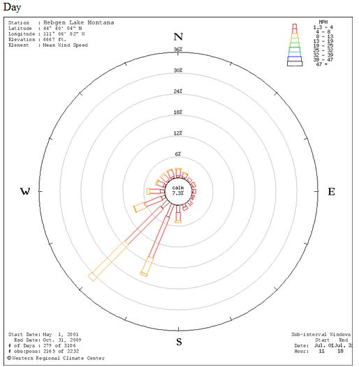
One of the more interesting tools on the site is one that will display a “wind rose” based on the location of your choice.  If you enter a lat/long it will access data from the nearest RAWS to draw wind roses for a one month period, one for daytime and another for night. As you may know, a wind rose shows the historic wind direction and speed. Here is an example for West Yellowstone, Montana. It shows average wind speed and direction for the month of July during the day, based on data from 2001 to 2009. About 32% of the time the wind is from the southwest and about 22% of the time it’s from the south-southwest. About 14% of the time the wind speed is 8-13 MPH from the southwest.

Wind Rose, West Yellowstone, MT

Mapping shortcuts

You will need a lat/long to use the tools above, but you’re in luck because I discovered a quick way to determine the lat/long anywhere using a new “Labs” feature in Google Maps. But first I’ll tell you about another new feature in Google Maps that will help you navigate more quickly to a specific location.

On the Google Maps page, click on “New” at the top of the page. It will then list some new optional features in “Google Maps Labs”. If you Enable “Drag ‘n’ Zoom“, you can drag your mouse cursor to draw a box, then it will zoom to that box. To use this feature, click on the new magnifying glass icon that will appear on the left side of the map page under the “+” and “-” scale bar. Each time you want to draw a box to zoom, you’ll need to click that icon again.

Then scroll down in the Labs options and Enable “LatLng Marker” (not LatLng Tooltip). Click Save Changes. This option will post a “mini marker” showing the lat/long when you right-click on the map and choose “drop LatLng Marker”.

You’re welcome.

Salt Lake Tribune, on the Mill Flat fire

Mill Flat Fire
Mill Flat Fire. Photo from the report.

The Salt Lake Tribune has an article about the Mill Flat fire that was managed as a “fire use” fire for almost a month, then escaped, ran out of the Dixie National Forest, and burned six homes in New Harmony, Utah on August 29, 2009. Wildfire Today reported on the release of the official review of the incident on April 5.

Here is an excerpt from the Tribune article:

Cedar City » A crew monitoring a wildfire in Washington County last summer waited too long to summon help, according to a review of the Mill Flat Fire made public recently by the U.S. Forest Service.

But that was just one problem in how the fire was handled.

The wildfire, sparked by lightning in a wilderness area in July 2009, crested a ridge and raced down two canyons into the residential community of New Harmony on Aug. 29. That night the fire destroyed three houses, heavily damaged three others and burned seven other outbuildings and corrals, leaving residents frustrated and angry the fire was not suppressed earlier.

Former town clerk Valene Scobel did not lose property, but was evacuated along with 150 residents that night.

“They let it burn way too long and it got out of hand,” said Scobel. “They mishandled it big time.”

The Forest Service report says fire managers acted reasonably, given their experience and training, and made public safety a priority. Lessons learned from decisions made during the fire should be used to improve future performance, it said.

But after letting the fire burn for weeks to clear out old growth, the fire crew had become “complacent.” A more aggressive containment approach should have been launched much sooner, the report said.

“Personnel new to the incident viewed the same situation with a much greater sense of urgency and recommended additional resources and more aggressive approach,” the document says. “Fire managers thought they had more time before the fire reached New Harmony.”

The fire stated in wilderness area on July 25, and was allowed to burn because it met criteria in the Forest Service’s land management plan for the area. The agency hoped the fire would eventually help re-establish aspen forests. A model projecting how much the fire could potentially spread in four weeks was completed in the early stages but was not updated after the fire grew significantly in August.

“Other fire behavior prediction tools may have shown a greater potential for the fire reaching New Harmony, but were not used,” says the review, adding that a fire behavior analyst was not assigned to the fire.

The report was also critical of the condition of a fuel break established before the fire erupted along the Forest Service boundary with New Harmony. The fuel break was not capable of stopping the fire because of its location, design and vegetation growth. Despite that, once the fire reached the two canyons into town, the inadequate fuel break was the only option to stop the blaze.

Communication between fire managers and the residents of New Harmony was another issue.

“Some state partners did not feel fully engaged in the fire’s management,” the report says. “Some [fire officials] did not speak up when they had concerns.”

Residents also expressed frustration. Some said they “were made to feel silly” by fire officials for being concerned and felt they were fed “propaganda” about the benefits of the fire.

Follow-up on 3 injured firefighters in North Carolina

Posted on Categories Uncategorized

On April 8 Wildfire Today covered the incident in Jackson County, North Carolina on which three firefighters were injured and three fire vehicles were burned or damaged. The North Carolina Forest Service has issued an undated “24-Hour Preliminary Briefing” about the incident:
==============================================

Subject: 24 Hour Preliminary Briefing

THE FOLLOWING INFORMATION IS PRELIMINARY AND SUBJECT TO CHANGE

Location:                     Jackson County, North Carolina

Date of Occurrence:    April 7, 2010

Incident:                      Bradley Branch Fire

Number of Injured: 3

Occupied Dwellings Lost:  1

Support Vehicles destroyed:  2

Narrative:

On Wednesday, April 7, 2010 at 1430, the NC Division of Forest Resources in Jackson County responded to a wildfire off Bradley Branch Road in the Wilmont Community. At approximately 1900 hours, after containment lines were complete, spot fires resulted in the loss of initial attack.  At approximately 1925 hours the fire made a run towards a house consuming 2 support vehicles (one DFR Type-6 Engine, one VFD Jeep crew transport, and minor damage to a VFD mini-pumper) and igniting the house. The house burned to the ground.  At this time 3 VFD personnel were injured during suppression efforts.  One (1) VFD member suffered minor smoke inhalation, was treated and released on-scene to continue suppression efforts.  One (1) VFD member suffered minor burns to this right forearm, was treated and released on-scene to continue suppression efforts.  One (1) VFD member complained of chest pains and shortness of breath and was air lifted to a regional medical facility, treated and released in the morning of April 8, 2010.

Suppression efforts continued through the evening with NC Division of Forest Resources and local VFD members. The fire was contained at approximately 0100 hours on April 8, 2010 consuming 65 acres of woodland.

An investigation team has been formed and is investigating the incident. Further reports will be forthcoming.