Kincade Fire burns into two fires from 2017

The Tubbs and Pocket Fires

Kincade Pocket Tubbs fires California
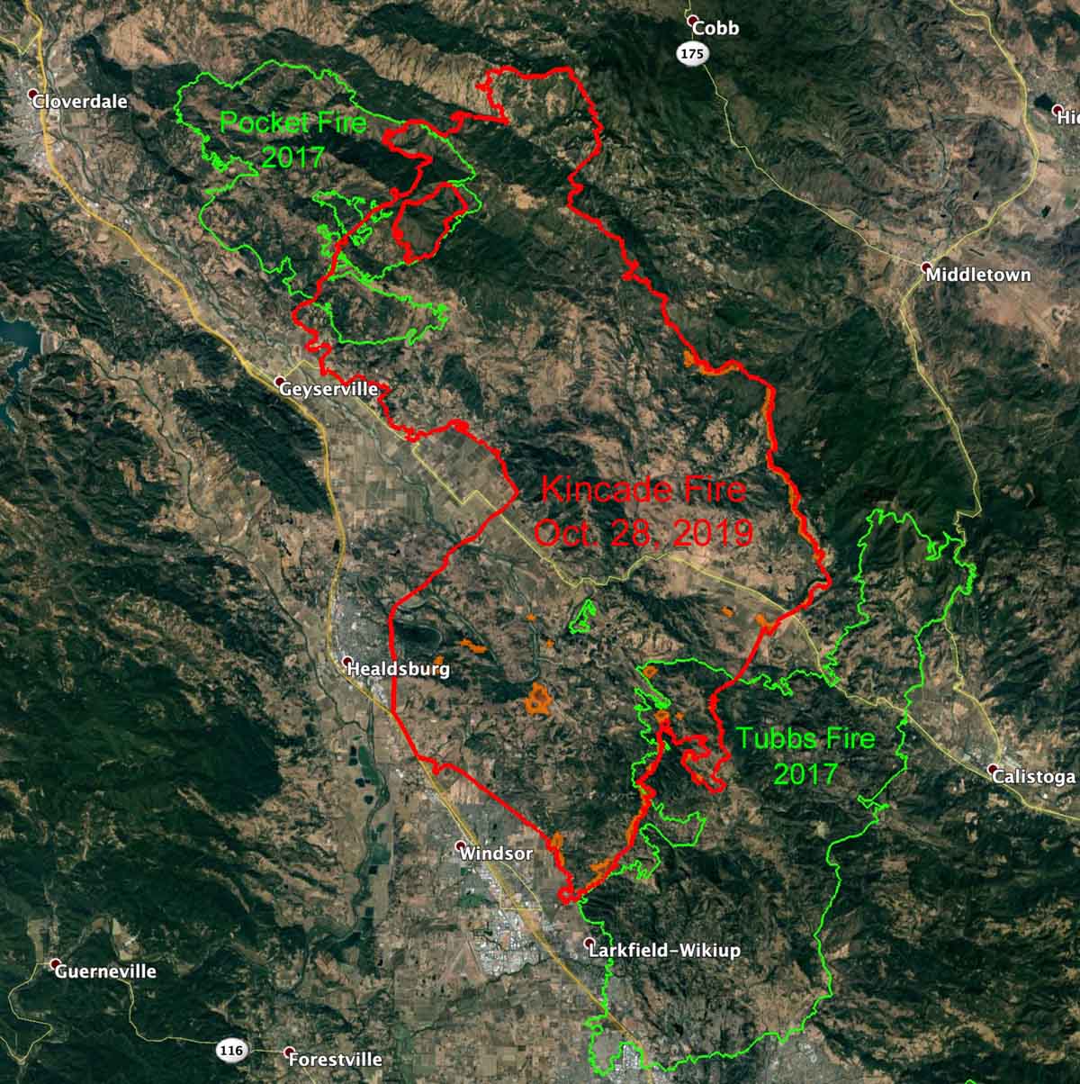
The perimeter of the Kincade Fire at 1:09 a.m. PDT October 28, 2019 seen in relation to the Tubbs and Pocket Fires on October 24, 2017. Click to enlarge.

When the wind is blowing at 50 to 90 mph not much can stop a wildfire, but the footprints of two fires that burned in October of 2017, the Tubbs and Pocket Fires, may have had some limited effect on the spread of the Kincade Fire that started last week.

When a wildfire burns into a two-year-old fire scar, usually there is much less vegetation than what had been carrying the fire — fewer tons per acre  and lighter fuels. For example if moving from chaparral to grass, the intensity, the amount of heat produced, and number and size of fire brands generated would be much less. That does not mean the fire would go out on it’s own, but unless the weather is extreme, like it has been in northern California off and on for the last week, there would be less resistance to control. In other words, easier to put out.

In some cases with very steep slopes or  heavy fuels such as very dense brush or timber, retardant dropped from an aircraft might have little effectiveness in dry windy conditions. But in the lighter vegetation that follows a fire, aircraft can be very efficient in slowing the spread long enough to allow firefighters on the ground to move in and actually suppress it.

During the extreme weather in northern California the last few days the Kincade Fire spread partially into the Pocket Fire on the north and the Tubbs Fire on the south. On the map above take note of the unburned red polygon, or island, inside the perimeter of the Pocket Fire.

During extreme winds and single-digit humidity a fire can keep spreading until it runs completely out of fuel, but it would be interesting to hear from folks that were on the Kincade Fire to find out if there was any significant change in fire intensity when it moved into the two fire scars.

Critical to extremely critical fire weather predicted for southern California

The fire weather in southern California for Tuesday night through Thursday, October 29-31, is predicted to be the most severe so far this year. Wind gusts of 50 to 70 mph are possible in the mountains and foothills and relative humidity could drop into the single digits.

In areas of northern California a Red Flag Warning will be in effect from 8 a.m.  PDT Tuesday until 4 p.m. PDT Wednesday. The wind is expected to be out of the north or northeast at 15 to 35 mph with gusts of 35 to 60 mph, locally higher in canyons and exposed ridges.

(Red Flag Warnings can be modified throughout the day as NWS offices around the country update and revise their weather forecasts.)

Getty Fire burns homes in Los Angeles

The fire was reported at about 1:30 a.m. near the southbound lanes of the 405 Freeway in Sepulveda Pass

map Getty Fire
The map shows the location of the Getty Fire in Los Angeles October, 28, 2019.

UPDATED at 4:31 p.m. PDT October 28, 2019

Monday afternoon Firefighters made progress in slowing the spread of the Getty Fire west of the 405 Freeway below the Getty Center museum in Los Angeles. Fire officials said the fire had burned eight homes and 618 acres.

An aggressive air assault after sunrise assisted firefighters on the ground. Numerous helicopters, large air tankers, plus two DC-10 airtankers dropped retardant and water on the brush-covered slopes.

At 4 p.m. some evacuation orders were still in effect for about 10,000 homes, and the southbound lanes of the 405 freeway were closed from the junction of US 101 to Sunset Boulevard.


8:08 a.m. PDT October 28, 2019

The Getty Fire broke out Monday morning near the 405 Freeway below the Getty Center museum in Los Angeles causing authorities to issue evacuation orders for about 3,300 homes. (see map)

The fire was reported at about 1:30 a.m. near the southbound lanes of the 405 Freeway in Sepulveda Pass.

There are reports that several homes  have burned. The Los Angeles Fire Department reported at 7:30 a.m. that approximately 500 acres had burned.

Getty Fire
Getty Fire. ABC7.
Getty Fire
Getty Fire at 8:04 a.m. PDT October 28, 2019.

The home of Los Angeles Lakers star LeBron James was one of 3,300 affected by the Getty Fire.

Later he wrote on Twitter,”Finally found a place to accommodate us! Crazy night man!”

Firefighters on Kincade Fire prepare for Red Flag weather conditions

Two firefighters were burned Sunday

8:09 a.m. PDT October 29, 2019

map kincade fire California wildfire
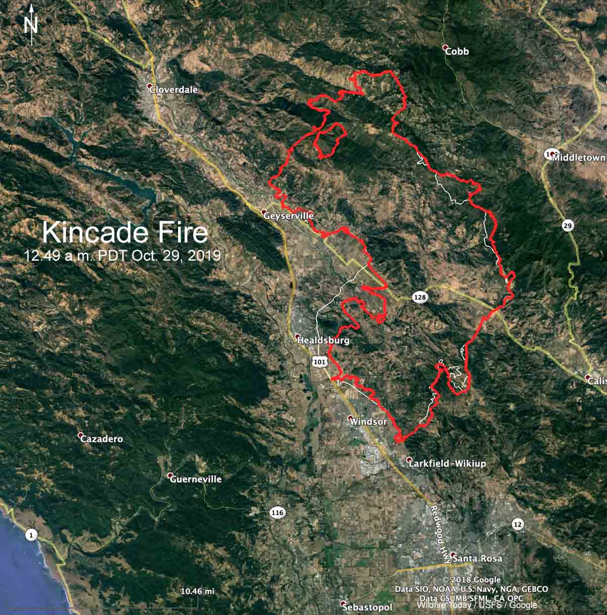
Map showing in red the perimeter of the Kincade Fire at 12:49 a.m. PDT October 29, 2019. The white line was the approximate perimeter about 24 hours before. Click to enlarge.

On Monday the Kincade Fire grew a relatively small amount, all of it on the east and southeast sides. CAL FIRE reports that the official size is 75,415 acres. (see map above)

(To see all articles on Wildfire Today about the Kincade Fire, including the most recent, click here.)

The weather on Monday gave firefighters the opportunity to make significant progress on the fire. But on Tuesday and Wednesday much of California is under a Red Flag Warning for strong winds and low humidity, including the Kincade Fire area.

Below is the National Weather Service forecast for wind and humidity near the fire at Geyserville. The wind barbs point to the direction the wind will be from. After 2 p.m. Tuesday the prediction is for 14 to 16 mph sustained winds out of the northeast with gusts of 21 to 33 until 4 a.m. Wednesday. The humidity will reach into the single digits and there will be no clouds or chance of precipitation.

Weather forecast Geyserville
Weather forecast for the Geyserville area October 29-30, 2019.

CAL FIRE reports that 57 homes and 5 commercial structures have been destroyed.

Resources assigned to the fire include 549 engines, 42 water tenders, 27 helicopters, 86 hand crews, and 66 dozers for a total of 4,548 personnel.

Many fixed wing air tankers have been used on the fire. The 747 Very Large Air Tanker (VLAT) has been activated as well as four DC-10 VLATs. These and other tankers, such as the C-130, 737, BAe-146, RJ85, P-3, and MD87 are being used on CAL FIRE and U.S. Forest Service contracts throughout California as fires erupt. There could be more if needed, but the Forest Service has not awarded the Call When Needed contracts for backup air tankers that was first advertised 517 days ago. The eight C-130 military Modular Airborne Fire Fighting System, MAFFS, could also be activated.


7:14 a.m. PDT October 28, 2019

Strong northeast winds that continued Sunday pushed the Kincade Fire to Highway 101 south of Healdsburg, California. The map below indicates that the fire may have been stopped before entering the city.

Two firefighters were burned yesterday. CAL FIRE spokesperson Jonathan Cox said one firefighter with serious burn injuries was airlifted to University of California Davis Medical Center.

Sunday afternoon CAL FIRE reported that the fire had burned 54,298 acres, but an overnight mapping flight found that number had increased to nearly 80,000 acres. Approximately 94 structures have been destroyed and 17 damaged.

Continue reading “Firefighters on Kincade Fire prepare for Red Flag weather conditions”

New fires in northern California

Glen Cove Fire
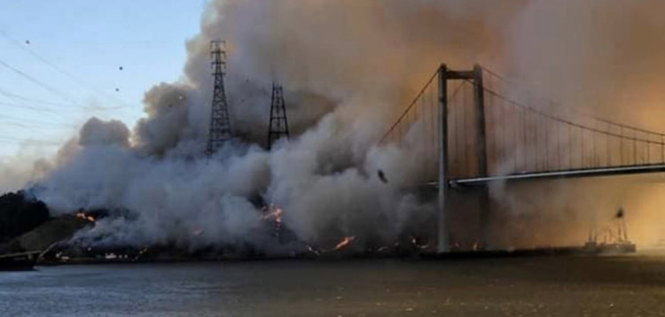
Glen Cove Fire south of south of Vallejo, California, northeast of the I-80 Carquinez Bridge, October 27, 2019. Photo by @arrowstewtoe.

Besides the 30,000-acre Kincade Fire which has been burning since October 23, other fires have started during the wind event in northern California. We will attempt to collect some brief information about some of them.


UPDATED at 5:20 p.m. PDT October 27, 2019

Burris Fire, southeast of Willits, California, 7 miles east of the intersection of Highways 101 and 20. Evacuations are occurring (more information). CAL FIRE reported at 5:20 p.m. it was 350 acres.

There is a 1,000-acre fire in the Grizzly Island Wildlife Area south of Fairfield. Name unknown. (see photo below)

Fire Grizzly Island Wildlife
Fire in the Grizzly Island Wildlife Area south of Fairfield. Photo from the Mt. Vaca 5 camera at 5:18 p.m. PDT Oct. 27, 2019.

UPDATED at 12:22 p.m. PDT October 27, 2019

Glen Cove Fire, south of Vallejo, northeast of the I-80 Carquinez Bridge. The Interstate is closed in both directions.

A fire in Crockett south of the I-80 bridge has burned about 200 acres. There is a possibility this is a spot fire from the Glen Cove Fire on the north side of the I-80 Carquinez Bridge, over half a mile away. From Contra Costa County: “Evacuations are under way in areas of Crockett south of Pomona street. Residents in other portions of the town should prepare now in case an evacuation is ordered. The evacuation center for Crockett residents is located at the Hercules Swim Center at 2001 Refugio Valley Road in Hercules.” Evacuations were lifted at about 12:50 p.m. Sunday.

Summerlake Fire and the Knightsen Avenue Fire. The evacuation orders for both of these fires in Contra Costa County have been lifted according to the county’s web site.

Leon Fire, southeast of Concord and Clayton. (Earlier there was confusion about the location of this fire.)

Rawson Fire off Gyle Road and Long Dirt Road, northwest of Corning in Tehama County was still 605 acres at 7:30 p.m. Sunday according to CAL FIRE. Firefighters have made good progress on the fire.

Some resources responding to the Arnold Fire near Arnold Drive and Highway 116 southwest of Sonoma have been cancelled, indicating firefighters could be getting it knocked down.