Forest Service releases video of explosion that started 46,000-acre fire

A U.S. Border Patrol agent pleaded guilty to starting the Sawmill Fire southeast of Tucson by shooting at an exploding target

The U.S. Forest Service has released a video of the exploding target that started what became the 46,000-acre Sawmill Fire southeast of Tucson in 2017.

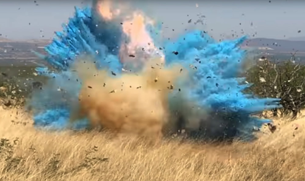
Border Patrol agent Dennis Dickey has pleaded guilty to starting the fire. He was holding an off duty party to celebrate his wife’s pregnancy at which the gender of his baby was revealed. He mixed colored powder into a Tannerite exploding target which would show blue or pink smoke when shot with a rifle. The target exploded as planned, revealing the blue powder, but it started what became the Sawmill Fire. A witness recorded video of the explosion.
exploding target starts fire wildfire
A screenshot from the video below showing the exploding target that started what became the 46,000-acre Sawmill fire.

Agent Dickey set up the dangerous device at a location where it was surrounded by dry grass and mesquite trees. At the end of the video a voice can be heard shouting twice, “Start packing up!”.

The video obtained by the Arizona Daily Star from the U.S. Forest Service through the Freedom of Information Act  is below.

One of the commenters where the video is posted on YouTube, wrote, “I feel bad for the poor baby boy who’s inheriting those genes.”

Agent Dickey said he attempted to put out the fire but when that failed, he reported it. At one point during the next week at least 799 firefighters were working to put out the fire, which ran up costs of approximately $8.2 million according to the May 5, 2017 national Situation Report.

On April 23, 2017, the day the fire started, the Hopkins weather station not far from where the fire began near Madera Canyon, recorded a high temperature of 80 degrees, 11 mph WSW winds gusting to 25, and 6 percent relative humidity. The weather station is at 7,100 feet and the location of the party where the fire started is most likely around 4,000 feet. If correct, this would put the temperature at the fire origin between 90 and 100 degrees.

news release from the U.S. attorney’s office said Agent Dickey will make an initial payment of $100,000, then make monthly payments after that. According to the Arizona Daily Star and the Green Valley News, he agreed in court to pay $500 a month for the next 20 years, which adds up to $120,000, for a total of $220,000 including the first payment. He also will be sentenced to 5 years of probation and agreed to participate in a public service announcement with the U.S. Forest Service concerning the cause of the Sawmill fire.

Exploding targets consist of two ingredients that when mixed by the end user explode when shot by a high-velocity projectile. They have caused many fires since they became more popular in recent years, have been banned in some areas, and caused the death of one person. After the ingredients are combined, the compound is illegal to transport and is classified as an explosive by the Bureau of Alcohol, Tobacco, and Firearms.

Hundreds evacuate from Queensland wildfires during “unprecedented” conditions

The state has had unusually severe fire weather and more is in the forecast for the rest of this week

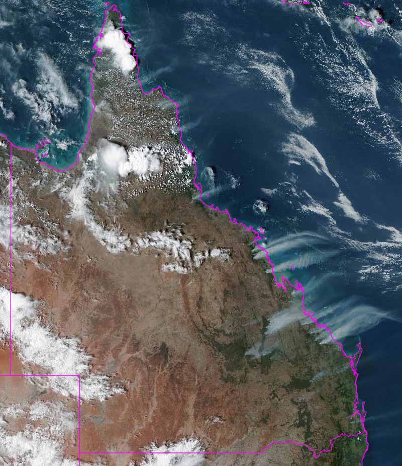
Queensland, Australia satellite photo smoke wildfires
Satellite photo of Queensland, Australia, showing smoke from wildfires. Photo taken at 0600z Nov. 26, 2018.

(UPDATED at 8 a.m. PST November 27, 2018)

The siege of wildfires in Queensland, Australia continues with approximately 80 blazes burning across the state. This is normally the wet season there, but unprecedented warm, dry, windy weather has set up conditions ripe for large, rapidly spreading fires.

At least two are forcing evacuations. Below is information provided by Queensland Fire and Emergency Services:

  • LEAVE NOW: Dalrymple Heights bushfire as at 12am Wed 28 Nov.Currently, as at 12am Wednesday 28 November, a large fast-moving fire is travelling in a south westerly direction towards Dalrymple Heights. It is currently impacting Snake Road and Chelmans Road. The fire could have a significant impact on the community. Fire crews are working to protect properties along Snake Road and Chelmans Road but firefighters may not be able to protect every property. You should not expect a firefighter at your door. Power, water, and mobile phone service may be lost.
  • LEAVE IMMEDIATELY: Deepwater, Baffle Creek, Rules Beach, Oyster Creek – bushfire as at 11.40pm Tues 27 Nov.Currently at 11.40pm Tuesday 27 November, an extremely large and intense fire is traveling in a south-westerly direction towards Muller Road. It is expected to impact Baffle Creek, Rules Beach and Oyster Creek in the coming hours. The fire is expected to have a significant impact on the community. All Deepwater, Baffle Creek, Rules Beach and Oyster Creek residents should evacuate in a westerly direction towards Miriam Vale using Tableland Road and Fingerboard Road. The crossing at Hills Road, Coast Road and Oyster Creek Road, Baffle Creek was under threat, but firefighters have managed to prevent the fire spreading to the crossing at this time.

(Originally published at 11:41 a.m. PST November 26, 2018)

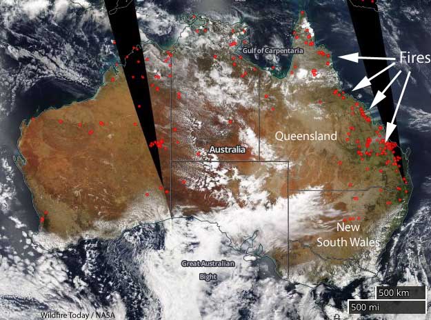
map wildfires Queensland Australia
The red dots represent heat detected in Australia by a satellite November 26, 2018.

Hundreds of residents have evacuated their homes in northeast Australia in the state of Queensland due to large wildfires. On Monday fire officials said a fire near Deepwater had burned 17,000 hectares (42,000 acres) and had a fire front 60 kilometers (37 miles)long.

map wildfires Queensland Australia
Smoke from wildfires in Queensland, Australia photographed by a satellite November 26, 2018.

State Emergency Service volunteers have been knocking on doors to tell people to leave their homes in Deepwater, Baffle Creek, Rules Beach, and Oyster Creek.

The bushfire in the Deepwater area of Queensland. QF&E photo.

At 6:50 p.m. local time November 26, the dangerous and unpredictable fire was spreading in a south, south-west direction from Capricornia Drive and Pacific Drive at Deepwater towards Baffle Creek, Rules Beach and Oyster Creek. At that time it was impacting the Deepwater community and was expected to begin impacting Baffle Creek, Rules Beach and Oyster Creek in a few hours.

This is normally the wet season in Queensland, unlike areas farther south in New South Wales and Victoria.

“The central Queensland fire situation is unprecedented for its ferocity, the low humidity, the extreme heat and variable winds”, Annastacia Palaszczuk, the Premier of Queensland said. “Other fires and heat waves are a threat in other parts of our state.”

The temperature for the rest of this week at Baffle Creek, one of the areas being evacuated, will be about 10 degrees F (6 degrees C) warmer than normal for the date, ranging from 88 to 95 F (31 to 35 C), along with wind speeds exceeding 10 mph mostly out of the northeast.

“In this part of the world we have not experienced these conditions before,” Queensland Fire and Emergency Services Commissioner Katarina Carroll said on Monday. “It is unprecedented.”

For the first time a large air tanker is being used in Queensland. The 737 under contract with the New South Wales Rural Fire Service is helping out.

Climate assessment predicts increasing wildfires

By mid-century western wildfires could increase 200% to 600%

At 2 p.m. Friday on the day after Thanksgiving President Trump’s administration released an important document about our climate. Required every four years by a 1990 act of Congress, the Fourth National Climate Assessment focuses on the human welfare, societal, and environmental elements of climate change.

Surprising in its bluntness, it lays out the devastating effects on the economy, health, environment, and wildfires. Within the 1,656-page document wildfires are covered rather extensively and photos of fires are used several times in the headers of sections, like the one below for Chapter 1 (which may have been taken at the Howe Ridge Fire in Glacier National Park in Montana in August).

The scientists concluded that by the middle of this century, the annual area burned in the western United States could increase 2–6 times from the present, depending on the geographic area, ecosystem, and local climate. The area burned by lightning-ignited wildfires could increase 30 percent by 2060.

In the Southeast rising temperatures and increases in the duration and intensity of drought are expected to increase wildfire occurrence and also reduce the effectiveness of prescribed fire. Intra-annual droughts, like the one in 2016, are expected to become more frequent in the future. Thus, drought and greater fire activity are expected to continue to transform forest ecosystems in the region.

In the Southwest, recent wildfires have made California ecosystems and Southwest forests net carbon emitters (they are releasing more carbon to the atmosphere than they are storing). With continued greenhouse gas emissions, models project more wildfire across the area. Under higher emissions, fire frequency could increase 25%, and the frequency of very large fires (greater than 5,000 hectares) could triple.

The Northwest is likely to continue to warm during all seasons under all future scenarios, although the rate of warming depends on current and future emissions. The warming trend is projected to be accentuated in certain mountain areas in late winter and spring, further exacerbating snowpack loss and increasing the risk for insect infestations and wildfires. In central Idaho and eastern Oregon and Washington, vast mountain areas have already been transformed by mountain pine beetle infestations, wildfires, or both, but the western Cascades and coastal mountain ranges have less experience with these growing threats. Forests in the interior Northwest are changing rapidly because of increasing wildfire and insect and disease damage, attributed largely to a changing climate. These changes are expected to increase as temperatures increase and as summer droughts deepen.

Below are wildfire-related excerpts from the report.


Climate assessment overview

Chapter 1: Overview

The impacts of climate change and extreme weather on natural and built systems are often considered from the perspective of individual sectors: how does a changing climate impact water resources, the electric grid, or the food system? None of these sectors, however, exists in isolation. The natural, built, and social systems we rely on are all interconnected, and impacts and management choices within one sector may have cascading effects on the others.

Continue reading “Climate assessment predicts increasing wildfires”

Rain stops the spread of the Camp Fire

The blaze in Northern California is nearly contained

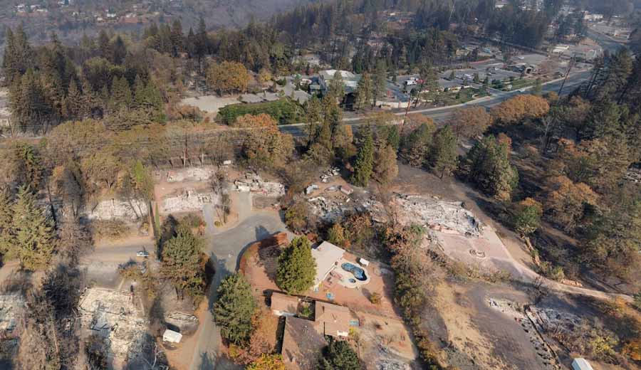
aerial photo Paradise Camp Fire
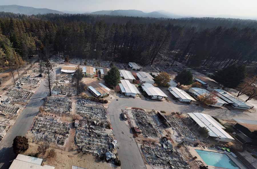
Aerial photo, off Herb Lane near Skyway in Paradise. From the Butte County drone mapping project.

Large quantities of rain that began Wednesday are helping firefighters contain the Camp Fire that devastated most of Paradise and the adjacent Concow community in Northern California. Rainfall in the last 72 hours in the county, Butte County, varied from 0.94″ to 7.10″.

To see all of the articles on Wildfire Today about the Camp Fire, including the most recent, click HERE.

CAL FIRE reports that the only uncontained section of the fire is in steep, rugged terrain that is unsafe for firefighters to access due to the heavy rains. There is indirect control line in that area and firefighters are monitoring the situation. Once safe to do so, crews will assess the situation and determine if direct line is necessary. The agency said the fire has burned 153,336 acres.

After the rain this week the Redding Searchlight quoted Stephen Horner, a public information officer for the Camp Fire, as saying, “The fire is out”. Large wildfires, especially megafires like this one, are not usually declared officially “out” until there is nothing burning anywhere within the perimeter. In spite of rain and snow, trees, roots, and logs can continue burning for months; some may overwinter and continue to burn into the following Spring.

The number of fatalities has risen to 84 with 475 reported as unaccounted for. Almost 14,000 homes have been destroyed.

This week some residents of Magalia were allowed to return to their homes, but other areas, especially in Paradise, are still under evacuation orders.

The rain has made it much more difficult to search through the ashes to find and recover bodies.

One of the primary tasks still facing firefighters is the removal of hazardous trees that are still standing but are dead or partially burned and likely to fall.

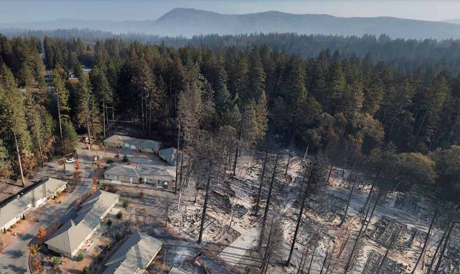
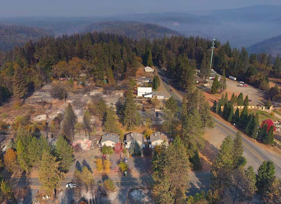
Agencies in Butte County have worked with cooperators to acquire aerial photography of the populated areas that were the most severely affected by the Camp Fire. On 500 drone flights they took 70,000 photos that have been georeferenced and formatted into a map. The still photos, videos, and 360-degree images can help residents check the status of their homes. It was a massive undertaking that was completed in just a couple of days by 16 drone teams and several organizations that used the data to produce the map and videos.

aerial photo Paradise Camp Fire
Near Orchard Drive in Paradise. From the Butte County drone mapping project.

Drones photograph the damage in Paradise caused by the Camp Fire

The photos and videos can help residents check the status of their homes

Camp Fire drone photo
Photo taken by a drone in Paradise near Kilcrease Circle.

A large group of mapping and drone experts have photographed from the air the Paradise, California area that was devastated by the Camp Fire that roared through the communities November 8. The photos and videos shot by drones were all georeferenced and put into a map format, making it possible for residents to check the status of their homes. Drones flew above all of the major roads shooting videos, and 360-degree photos were taken from the air in 200 locations which can be panned and zoomed. The resolution is very good since they were taken with 20 megapixel cameras.

Camp Fire drone photo
Photo taken by a drone in Magalia near Indian Drive.

The maps can be viewed at the Butte County website. The site is a little glitchy and I found that it did not work well with the Chrome browser; the street names, videos, and 360-degree photos were not available. It worked fairly well with the Firefox browser, but a window on the left side could not be eliminated which obscured about half the map. I did not try it with Internet Explorer. In spite of these issues, what the group accomplished in about two days is an incredible achievement, and may be the first time the process has been used on this scale to provide such detailed information to a population suffering from a natural disaster.

To see all of the articles on Wildfire Today about the Camp Fire, including the most recent, click HERE.

The 16 teams of drone operators conducted 500 flights in two days to collect 70,000 photos over 17,000 acres.

In addition to this resource, officials are mapping one by one the structures affected by the fire. That map is also available to residents who want to check on the status of their homes.

The video below explains the technical details of how the imagery was collected and displayed.

A 737 air tanker used for the first time

On November 22 Air Tanker 137 dropped on a bushfire in New South Wales

tanker 137 Boeing 737 drop first wildfire bushfire
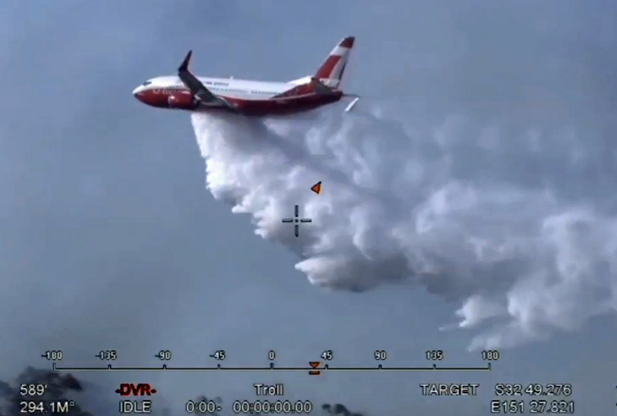
On November 22 Air Tanker 137 made the first drop by a Boeing 737 on an active fire. It occurred in the Hunter region of New South Wales, Australia. Screenshot from NSW RFS video.

(This article was first published on Fire Aviation)

On November 22 Air Tanker 137 made the first drop by a Boeing 737 on an active fire. It occurred in the Hunter region of New South Wales, Australia.

Coulson completed the conversion of the 737 a few months ago and it is now working on a contract with the New South Wales Rural Fire Service during their summer. Nicknamed “Gaia”, it arrived at Richmond RAAF Base near Sydney November 11 after a multi-day trip across the equator. It will be primarily based at the RAAF Base along with three other large air tankers from North America — a C-130Q (T-134), and two RJ85s (T-165 and T-166). Two other large air tankers will be based in Victoria at Avalon Airport in Melbourne, a C-130Q (T-131), and an RJ85 (T-163).

Going by the coordinates on the images, the fire T-137 dropped on was very close to the Kurri Kurri Hospital southwest of Heddon Greta. The NSW RFS reported at 8:14 p.m. local time on November 22 that firefighters assisted by aircraft had slowed the spread of the fire. They estimated it had burned 61 hectares (151 acres).

bushfire Kurri Kurri Hospital NSW
The coordinates indicate the approximate location of the drop by Tanker 137. Google Earth.
tanker 137 Boeing 737 drop first wildfire bushfire
On November 22 Air Tanker 137 made the first drop by a Boeing 737 on an active fire. It occurred in the Hunter region of New South Wales, Australia. Screenshot from NSW RFS video. Click to enlarge.