Junior firefighters had fun learning how backpack pumps work at the Arizona National Parks Festival in Tucson, Arizona Sunday.
NPS photos
News and opinion about wildland fire
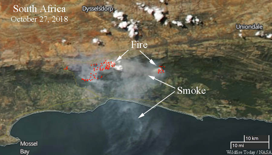
Firefighters in South Africa have been busy for the last week battling large wildfires. A week ago a helicopter pilot was killed while working on one of the fires.
Below is an excerpt from an article in The South African, October 29, 2018.
A fierce Garden Route fire has engulfed part of the Outeniqua Mountain range near George, leading residents to evacuate homes and smallholdings.
The blaze, which began over the weekend, has been fanned by scorching temperatures and strong winds. George Municipality has initiated voluntary evacuation procedures for residents in the danger zone, which is currently regarded as the northern outskirts of the nearby town.
George fire causes panic as residents evacuate.
On Monday morning, George Municipality issued an evacuation warning for residents on the outskirts of town. Residents of Blanco Golden Valley and Stepaside were urged to vacate their homes as a precautionary measure.
The local traffic department and the South African Police Service (SAPS) are currently assisting residents in the area, ushering them to safety at the Town Hall. Residents of Heatherlands and Fernridge in George have also been urged to evacuate their properties and find shelter at the Blanco Community Hall.
 Following reports that at least 12 of the wildfires that devastated areas of the California wine country last year were caused by Pacific Gas & Electric power lines, the company has decided to initiate helicopter patrols. The aircraft will inspect lines in El Dorado County in the areas of Camino, Cedar Grove, Pollock Pines, Sly Park, Newtown, Old Fort Jim, Sierra Springs, Pleasant Valley, Sweeneys Crossing and Happy Valley through October 28.
The National Weather Service predicts breezy conditions and elevated wildfire danger in some areas of Northern California Sunday and also Tuesday through Thursday of next week.
In the past PG&E has contracted for at least one Blackhawk helicopter that they use for heavy lift operations.

In July of 2017 a helicopter under contract to PG&E crashed near Donner Summit in California. The CHP said the six people on board had only minor injuries and none were transported to a hospital.

In the natural world one environmental event or disturbance can initiate or be part of a series of cascading events that intensify the impacts of natural hazards, possibly turning them into disasters.
An article at The Conversation explores how these effects can be enhanced by a warming climate. Below is an excerpt from an article written by Amir AghaKouchak (UC Irvine) and Farshid Vahedifard (Mississippi State University).
“Multiple hazardous events are considered cascading when they act as a series of toppling dominoes, such as flooding and landslides that occur after rain over wildfires. Cascading events may begin in small areas but can intensify and spread to influence larger areas.
[…]
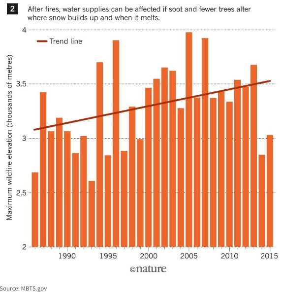
“Also, the severity of these cascading weather events worsens in a warming world. Drought-stricken areas become more vulnerable to wildfires. And snow and ice are melting earlier, altering the timing of runoff. This has a direct relationship with the fact that the fire season across the globe has extended by 20 percent since the 1980s. Earlier snowmelt increases the chance of low flows in the dry season and can make forests and vegetation more vulnerable to fires.
“These links spread further as wildfires occur at elevations never imagined before. As fires destroy the forest canopy on high mountain ranges, the way snow accumulates is altered. Snow melts faster because soot deposited on the snow absorbs heat. Similarly, as drought dust is released, snow melts at a higher rate, as has been seen in the Upper Colorado River Basin.
[…]
“When landscapes are charred during wildfires, they become more vulnerable to landslides and flooding. In January, a debris flow event in Montecito, California killed 21 people and injured more than 160. Just one month before the landslide, the soil on the town’s steep slopes were destabilized in [the Thomas Fire]. After a storm brought torrential downpours, a 5-meter high wave of mud, tree branches and boulders swept down the slopes and into people’s homes.”
(This article first appeared on Fire Aviation)

A helicopter pilot died in a crash October 23 while helping firefighters extinguish a wildfire in South Africa.
Nico Heyns, 65, was flying a Huey owned by Kishuga Aviation that was under contract to the firefighting agency Working On Fire.
The accident occurred the Vermaaklikheid area, about 40km from Riversdale, around 9:50 a.m.
Mr. Heyns was supposed to be off duty that day but interrupted his leave to help with the fire. The cause of the crash has not been determined.
We are utterly devastated by the untimely passing of our beloved pilot Nico Heyns. He will be sorely missed by us all. Our sincere and heartfelt condolences to his family and friends. @wo_fire pic.twitter.com/u0PXWXAVSd
— Kishugu (@kishugu) October 24, 2018
Police spokesperson Captain Malcolm Pojie said, “Police had to arrange for the speedy removal of the body to save it from the fire that was engulfing the area.”
Mr. Heyns, a veteran pilot with more than 20 years experience, formerly owned Heyns Helicopter Service and was well known in the aviation community.
Our sincere condolences go out to his family, friends, and co-workers.
Working on Fire wishes to extend our heartfelt condolences to the family of Nico Heyns as well as colleagues and the firefighting fraternity. Our first and foremost priority at this stage is to provide the bereaved with support as needed and we will be meeting with the family. pic.twitter.com/cMenc0j9QZ
— Working on Fire (@wo_fire) October 24, 2018
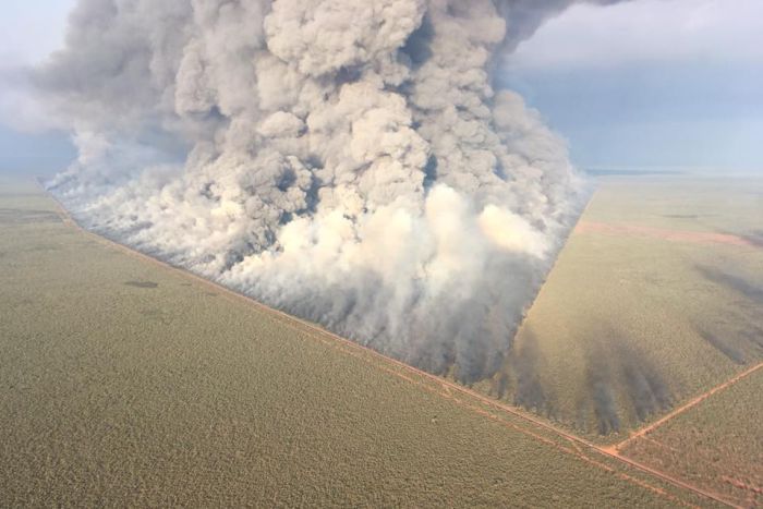
A bushfire that started October 11 in Western Australia 120km southeast of Broome burned 880,000 hectares, or 2,174,527 acres. Dry winds from variable directions and high temperatures made it very difficult to suppress. The remote location and a lack of water restricted the tactics to fighting fire with fire, constructing firelines with heavy equipment, and using aircraft.
When the wind direction changed last week, firefighters had to shut down the Great Northern Highway, National Route 1.
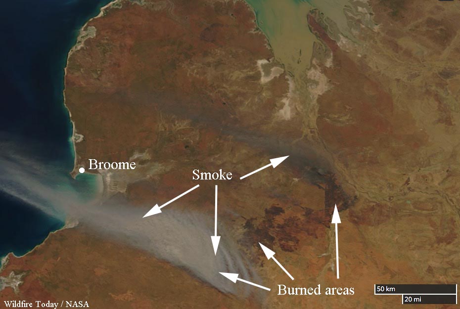
When we coined the term “megafire” for wildfires that exceed 100,000 acres, it was in the back of our mind that if a fire reached 1 million acres it would be called a “gigafire”.
In spite of the enormous size of the blaze in Western Australia there were no fatalities or damage to major structures.
The Department of Fire and Emergency Services (DFES) urged residents at Thangoo Homestead, Barn Hill Station, and Eco Beach last Tuesday to evacuate or actively defend their property.
DFES West Kimberley area officer Ben Muller said there were approximately 100 personnel fighting the fire.
The city of Broome was given the all clear Thursday morning.
Below is an excerpt from an article at TheWest.com:
Thangoo Station manager Rex McCormack said about half of the pastoral station was burnt but people and livestock were unscathed and water tanks and other important assets were undamaged.
“It is one of the biggest fires I remember from the last 10 years, but we felt safe in staying and defending the property,” he said.
“I didn’t feel scared in staying, I would have been more worried about that damage that could have occurred if I wasn’t there and it was more about being a resource to DFES.
“We were out back burning the property until about 1am last Wednesday, then up again at 6am.
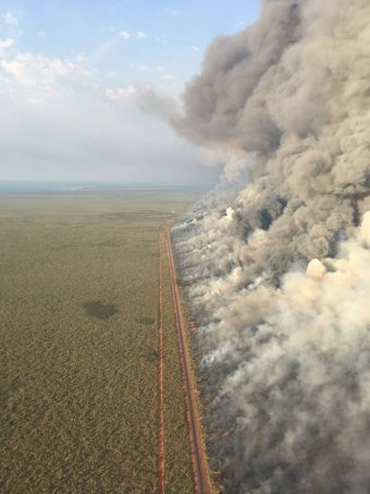
(UPDATED November 2, 2018)
Images below are from the Sentinel 2 10/23. First image is the original fire. Second image is from a secondary fire to the NE, both presently under control.
Bushfire in Australia burns over 2 million acres, becoming a “gigafire” https://t.co/4DSVh1YP8T … via @WildfireToday pic.twitter.com/Q1GYW2MmAm— Scott Cook (@scook2214) October 31, 2018