Above: On August 12 firefighters initiated burnouts as they constructed fireline. This can remove unburned vegetation between the line and the fire. Photo by William Ing.
With the heavy rain that hit the Hot Springs, South Dakota area Wednesday the threat from the Vineyard Fire has greatly diminished, with residents reporting around an inch of precipitation. On Tuesday the firefighters stopped providing updates on the Facebook page created for the fire and an entry was never made on InciWeb — indications that the firefighting activities have slowed.
But rain can’t completely extinguish a wildfire that involves timber. Roots can smolder underground for weeks or months and burning logs don’t always go out by simply applying water from above.
Map of the Vineyard Fire.
According to the last official update from Great Plains Fire Information on August 14 the fire had burned 560 acres, all evacuations had been lifted, and the cause was still under investigation.
William Ing took these photos on August 11 and 12 from Butler Park and the Dairy Queen in Hot Springs. Thanks William!
An Air National Guard Blackhawk helicopter drops water adjacent to onlooking firefighters (lower right).
These “Firewatch Cobras” have infrared sensors that can detect heat from fires. There is video in the article in which the pilot directs firefighters on the ground to a hot spot near the line on the Jesusita fire near Santa Barbara on May 12, 2009. The heat source is so small that the firefighters walked past it and over it several times, but the pilot could easily see it using the infrared equipment.
That video was filmed during daylight hours. Eight years later we now have the ability to have an unmanned aerial vehicle with sophisticated sensors orbit continuously over a fire, day and night, for 18 to 20 hours depending on the weight of its payload. If an incident management team on a fire activates a couple of these using the recently awarded Call When Needed contract, firefighters can have greatly enhanced situational awareness with near real time video.
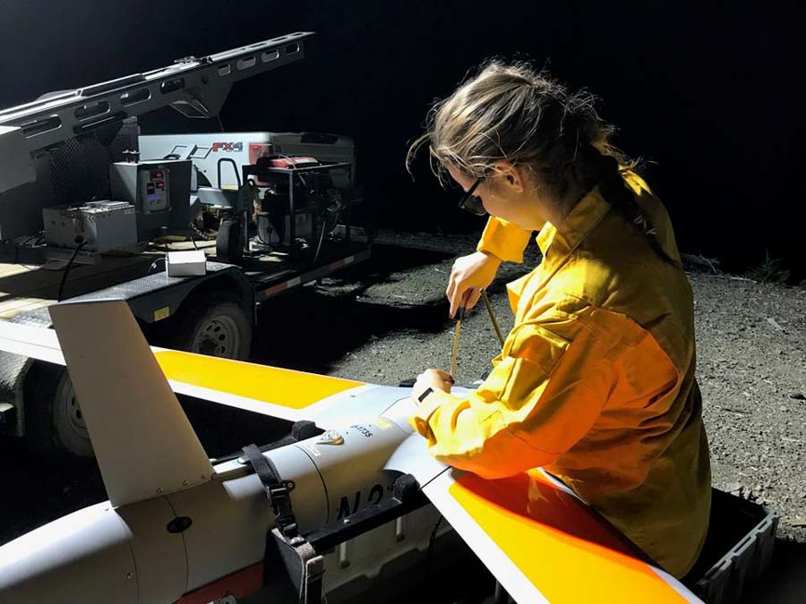
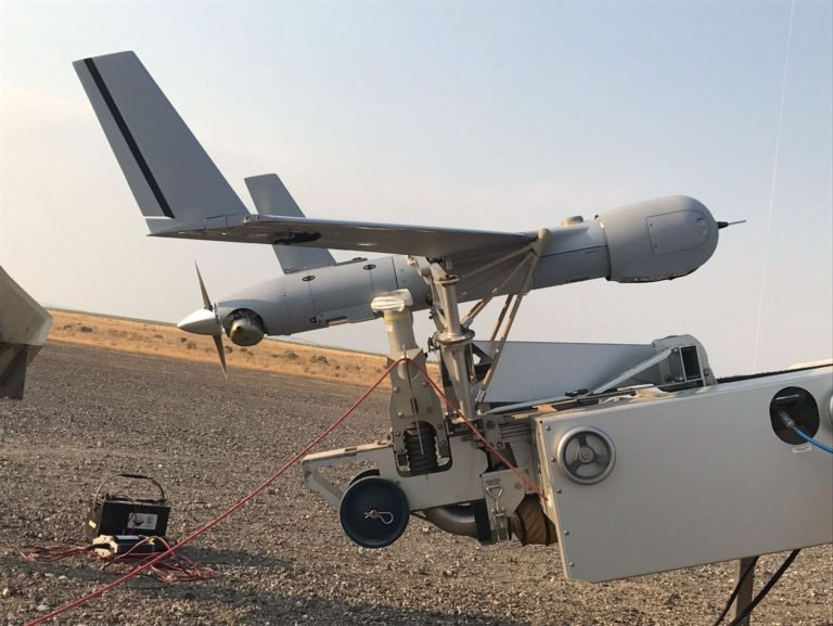
Insitu was one of four companies that won CWN contracts in May. On the Taylor Fire in southwest Oregon on August 5, firefighters requested that the company’s ScanEagle aircraft monitor an overnight burn operation they were conducting along a ridge top road. As it orbited in the darkness at 8,500 feet, the sensors and the pilot detected a spot fire about 100 feet outside the fireline in the “green” unburned area.
The pilot talked directly with firefighters in an engine, telling them where it was.
Engine 66 stop there, spot fire is out your passenger door, 100 feet.
As you can see in the video below, the firefighters, it looked like at least three of them, searched the area and found the spot fire, which they said was about one foot square.
Depending on your taste in music, you will either want to turn up the sound in the video, or turn it off. I doubt if there’s any middle ground. There is no narration, so you won’t miss anything with the sound off.
The ScanEagle was launched from and recovered within the Temporary Flight Restriction over the fire. It was flown beyond visual line of sight in accordance with the 2015 FAA/Department of the Interior Memorandum of Understanding.
We have often written about the Holy Grail of Wildland Firefighter Safety — knowing in real time the location of the fire and the location of personnel. Many assumed the location of the fire would be the most difficult obstacle to overcome. But apparently the technology, suitable and practical enough to be used on a wildfire, is on a CWN contract. BOOM!
The location of firefighters can also be solved. The technology exists now. Many agencies are using various systems, especially metropolitan law enforcement and fire organizations, but the federal land management agencies and most of the larger state fire organizations are dragging their feet. Earlier this year CAL FIRE took a step in the right direction when they issued a contract to provide technology in 1,200 state-owned vehicles that will facilitate mission critical data communications over a variety of networks (broadband, narrowband and satellite). This will include tracking the location of firefighting vehicles, but probably not dismounted personnel.
Complex terrain is one of the difficulties in continuously tracking the location of resources on a wildland fire, but there are ways to get around this, including putting radio repeaters in drones, perhaps the same one that is tracking the fire.
One of these days, drones will be on automatic dispatch along with engines, crews, and other aircraft. I know — a lot of deconflicting of aircraft has to be worked out, but it WILL happen.
The map above shows the prediction for the distribution of wildfire smoke at 6 p.m. MDT August 14, 2018. It looks like it is going to be pretty rough today in Washington, Oregon, Idaho, Montana, Wyoming, and parts of Northern California.
Draper City, Utah has identified the firefighter that was killed August 13 on the Mendocino Complex as Draper Battalion Chief Matthew Burchett. He leaves behind his wife and their 6-year-old son.
Below is a press release that the city issued today.
Press Release 8/14/2018 from Draper City.
1020 East Pioneer Rd.
Draper, UT 84020
Media Release
August 14, 2018
Draper Battalion Chief Dies Fighting Mendocino Fire
DRAPER, Utah. – It is with tremendous sadness that we announce the tragic loss of one of our own. Last night while fighting the Mendocino Complex Wildfire in California, Draper Battalion Chief Matthew Burchett lost his life in the line of duty. Draper deployed five fire fighters to California on August 2nd, and the team has worked tirelessly to protect lives and property. The entire community of Draper is grieving our loss.
Chief Burchett came to Draper City Fire Department in May of this year. Prior to working for Draper, he worked for Unified Fire Authority for the past 20 years. Chief Burchett had extensive experience in wildland and structure fire. Chief Burchett leaves behind a wife and a young son. He was 42 years old.
This is not only a loss for our Draper Fire Department, but a loss for all fire departments in the Nation.
We appreciate all the heartfelt support from the Draper Community, Cal Fire, the State of Utah, and our family of firefighters from across the nation.
At this time, we ask for some privacy for Chief Burchett’s family as they process this tragedy.
In the coming days we will have information about funeral plans, a donation fund for Matt’s family and more details as they become available.
Another release issued by Draper City on August 14 included a statement from the Fire Chief:
Draper City’s Fire Chief Clint Smith is out of the country and he has given us his statement about this tragic event.
“Draper City Fire Department has no words to describe the depth of sorrow we are feeling upon learning of the death of Battalion Chief Matt Burchett while assisting with the devastating California Wildfires. Matt is a true hero who has given the ultimate sacrifice while serving others. Matt is a strong leader and experienced wildland firefighter who always put the safety and needs of his subordinates first, but most of all, Matt was a devoted husband and loving father. His family was his world. We are grateful to those fellow firefighters that were with Matt and for the immediate aid they were able to render. We pray for all firefighters, friend and family affected by this tragic loss. This event has rocked our small department to its very core but we will work to honor Matt’s legacy and sacrifice and care for his family.”
(UPDATED at 8:22 a.m. PDT August 14, 2018)
Officials on the Mendocino Complex of Fires reported Monday night that a Utah firefighter who was working on the incident was killed in an accident. No other details or the identity of the person has been released.
Fact finding is ongoing and notification of next of kin is in progress.
We send out our sincere condolences to the firefighter’s friends, family, and co-workers.
The sender of the tweet below is in Draper City, Utah.
Our hearts are breaking as we announce the loss of one of Draper City’s firefighters in the Mendocino Fire last night. Words cannot explain how it feels to lose a true hero. We sent five of our team members to California to battle these terrible fires. A very sad day in Draper. pic.twitter.com/xwblMVzzJt
It has been a tragic summer in California. Five other agency employees or contractors have died in the line of duty in the last month while working on wildfires in the state:
-Andrew Jason Brake, a heavy equipment mechanic, died August 9 on the Carr Fire.
–Don Ray Smith, contract dozer operator, of Pollock Pines, CA, on the Carr Fire July 26.
–Redding fire Inspector Jeremy Stoke, Fire Inspector for the Redding, CA Fire department, on the Carr Fire July 26.
–Brian Hughes, Captain on National Park Service Arrowhead Hotshots, Ferguson Fire, July 29.
–Braden Varney, CAL FIRE Heavy Fire Equipment Operator, July 14, Ferguson Fire.
Thanks and a tip of the hat go out to Tom. Typos or errors, report them HERE.
The Ranch Fire has burned 295,970 acres east of Ukiah
(Originally published at 12:13 p.m. PDT August 13, 2018.)
A few days ago the 295,970-acre Ranch Fire, part of the Mendocino Complex of Fires east of Ukiah, California, became the largest wildfire in the recorded history of the state. It blew past the previous record set by last December’s Thomas Fire near Santa Barbara, exceeding it now by about 14,000 acres.
But the fire is not resting on its achievements — in recent days it has been very active on its north side where it has spread practically unfettered one to two miles farther north over the last seven days, approaching Lake Pillsbury.
(To see all articles on Wildfire Today about the Mendocino Complex of Fires, including the most recent, click HERE.)
The mapping flight Sunday night did not show any major fire activity on the rest of the fire, or on any of the perimeter of the other fire in the Complex, the River Fire west of Clear Lake.
The red lines represent the perimeters of the fires at 10 p.m. PDT August 12, 2018. The red shaded areas had intense heat at that time. The white line was the perimeter seven days before. Click to enlarge.
CAL FIRE reports that 147 residences have been destroyed in the two fires and another 1,025 remain threatened.
A very large army of firefighters are still battling the two fires, including 256 fire engines, 58 fire crews, 20 helicopters, 76 dozers, and 79 water tenders, for a total of 3,221 personnel.
CAL FIRE’s information about the Ranch Fire on August 13 included this:
The state has 18 wildfires with varying levels of evacuations in effect
Firefighters in Washington state have been very busy recently, especially Saturday when 68 new fires were detected, primarily in the eastern part of the state. Abundant lightning accompanied by strong winds and very dry fuels created critical fire conditions.
They currently have 18 fires with varying levels of evacuations in effect.
Map showing some of the large wildfires in Washington, August 12, 2018. Click to enlarge.
One of the largest is the 45,000-acre Grass Valley Fire that started August 11 west of Grand Coulee Dam. Firefighters report extreme fire behavior with running and spotting. Evacuations and road closures are in effect.
The Cougar Creek Fire has burned 18,890 acres 25 mi west of Chelan, WA. The fire is exhibiting extreme fire behavior. Evacuations are in effect.
The 15,975-acre Crescent Mountain Fire is 16 miles west of Winthrop, WA.