Are we experiencing a “new normal” of wildland fire behavior?

In the last 16 days four fighters and at least three civilians have been killed on two fires in California, the Ferguson and Carr Fires.

These two fatal fires that are still spreading have over 7,100 personnel working to put them out. Today, nationally, 24,641 are assigned to wildland fires according to the July 29 National Situation Report, including 584 hand crews and 1,689 fire engines. These are very high numbers that have not been reached very often.

There are risks associated with wildland fires, and the more people taking those risks, almost 25,000 today, the more likely it is that fatalities will occur. Struggling to knock down huge weather and fuel-driven fires, or having people assigned for months to a fire that is being managed with a less than full suppression strategy, exacerbates the situation, exposing more firefighters for longer periods of time.

Firefighters on the Carr Fire near Redding, an area very familiar with wildland fire, are saying that during the current drought and extreme heat, the fire has been spreading without regard to what’s in front of it.

Below is an excerpt from an article at KTVU about the Carr Fire:

“We’re not fighting a fire,” said Jonathan Cox, battalion chief with Cal Fire. “We’re trying to move people out of the path of it because it is now deadly, and it is now moving at speeds and in ways we have not seen before in this area.”

From Fox26Medford:

Carr Fire Unified Incident Commander Chief Brett Gouvea said, “This fire is extremely dangerous and moving with no regard to what’s in its path.” Homes, businesses and tens-of-thousands of acres reduced to rubble and ash.

Mark Brunton with CAL FIRE said, “We’ve seen rates of spread, which means the movement of the fire, that are unprecedented. They’re record-breaking.” And continuing to force families to evacuate.

It is too early to say if what we are seeing on fires this year and this decade is the new normal. But maybe it is time to step back and see how the current climate affects the management practices we are using. Are the long term decisions made 10 years ago still viable today? Are we suppressing or managing every fire the best way? At the rate we are using let burn (or less than full suppression) strategies, will we ever treat enough land to make a difference in the long run? Do we have enough funding and firefighters for let burn fires which can linger on for months? Oddly, the National Situation Report does not include any meaningful data about these less than full suppression fires (how I hate that term!), only that there are 39 of them on July 29.

A second firefighter killed on the Ferguson Fire

Another firefighter has been killed while working on the Ferguson Fire west of Yosemite National Park in California.

The Mariposa County Sheriff’s Office has confirmed that Sunday morning July 29 while battling the Ferguson Fire on the Sierra National Forest, a Sequoia and Kings Canyon National Park firefighter suffered a fatal injury.

The incident occurred just before 9:30 a.m. At the time, the firefighter and his crew were engaged in a tactical firing operation on the east side of the fire. They were operating in an area with a large amount of tree mortality. The firefighter was struck by a tree. He was treated on scene, but passed away before he could be transported to a hospital.

“The team at Sequoia and Kings Canyon National Park is devastated by this terrible news,” says Park Superintendent Woody Smeck in a statement released July 29. “Our deepest condolences go out to the firefighter’s family and loved ones. We grieve this loss with you.”

Further public information will be made available once the firefighter’s family has been notified.

The firefighter was escorted to the Stanislaus County Coroner’s office in Modesto, Calif., Sunday at 3:30 p.m.

The Ferguson Fire has burned over 54,000 acres since it started July 13, 2018.

Heavy Fire Equipment Operator Braden Varney was killed July 14, when his dozer rolled in steep terrain on the Ferguson Fire.

On July 26 two firefighters were entrapped and killed by the Carr Fire near Redding, California.

Our sincere condolences go out to the family, friends, and co-workers of all four of these firefighters.

Mendocino Complex of Fires tripled in size Saturday

The fires have burned from Mendocino County into Lake County in northern California.

The two fires that make up the Mendocino Complex of Fires were extremely active Saturday, growing from 9,500 to 28,000 acres, almost tripling in size according to very conservative figures released Sunday morning by CAL FIRE.

Both fires started in Mendocino County around noon on July 27 but have burned into Lake County.

(To see all of the articles on Wildfire Today about the Mendocino Complex of Fire, click HERE.)

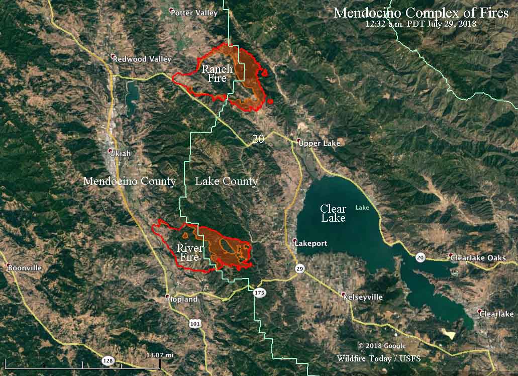
The Ranch Fire is 8 miles northwest of Ukiah, California and as of Saturday night had remained east of Highway 20. The River Fire is farther south and Saturday night spread to a point three miles west of Lakeport, a community on the west shore of Clear Lake.

map Mendocino Complex of Fires
The red line was the perimeter of the fires in the Mendocino Complex, as detected by infrared sensors at 12:32 a.m. PDT July 29, 2018. The red shaded areas represent intense heat at that time.

A number of areas in Mendocino and Lake County are under mandatory evacuation orders.

Four homes have burned in the River Fire, but another 4,600 are threatened.

Carr Fire still spreading, but away from Redding

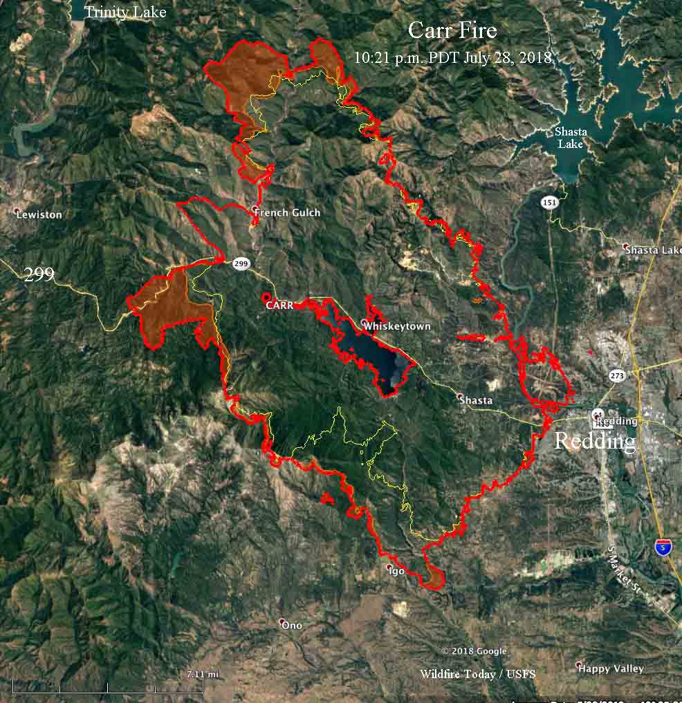
Above: The red line on the map shows the perimeter of the southeast side of the Carr Fire near Igo as determined by heat sensors on an aircraft at 10:21 p.m. PDT July 28, 2019. The red shaded areas indicate intense heat. The yellow line was the perimeter about 20 hours before.

(Originally published at 5:36 a.m. PDT July 29, 2018)

Firefighters on the Carr Fire are getting a handle on the portion of the blaze that burned into the west side of Redding, California, but it is still spreading away from the city to the south, west, and north.

map Carr Fire Redding
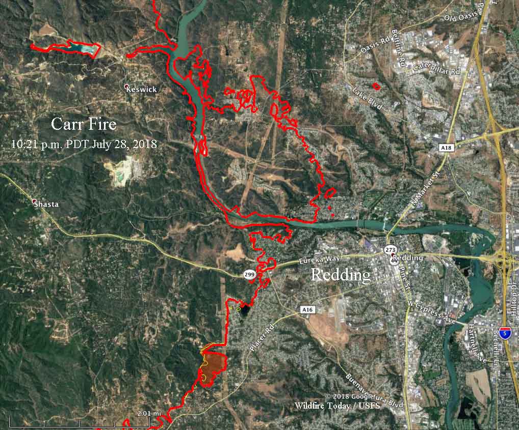
The red line shows the perimeter of the Carr Fire as determined by heat sensors on an aircraft at 10:21 p.m. PDT July 28, 2019. The red shaded areas indicate intense heat. The yellow line was the perimeter about 20 hours before.

Saturday’s additional growth added another 15,000 acres to bring the total size to about 95,000 acres. Southwest of Redding it burned through the Igo area, crossing Placer Road. At 10:21 PDT Saturday it remained east of Cloverdale Road and had progressed south to Clear Creek Road. North of Igo the fire spread about a mile to the southwest on Saturday.

To see all of the articles about the Carr Fire, including the most current, click HERE.

On the northwest side, by Saturday night the fire had come to within five air miles of Lewiston and Trinity Lake and moved about three miles further west along Highway 299, burning on both sides.

map Carr Fire Redding
The red line shows the perimeter of the east side of the Carr Fire near Redding as determined by heat sensors on an aircraft at 10:21 p.m. PDT July 28, 2019. The red shaded areas indicate intense heat. The yellow line was the perimeter about 20 hours before.

The number of fatalities on the Carr Fire rose to five Saturday when officials confirmed that two young children and their great-grandmother were found dead. James Roberts, 5, and Emily Roberts, 4, were stranded with Melody Bledsoe, 70, when the fire ran through the family’s property July 26 outside Redding, California.

That same day two firefighters were also killed at approximately 6:40 pm when a dramatic increase in fire behavior occurred on the east side of the Carr Fire. Entrapped in a burn over were a call when needed contract dozer operator, Don Ray Smith, 81, of Pollock Pines and Redding fire Inspector Jeremy Stoke who had been with the Fire Department since 2004.

CAL FIRE reports that 536 structures have burned, but has not broken the number down by residences and outbuildings.

Resources assigned to the fire include 334 fire engines, 59 hand crews, 17 helicopters, 68 dozers, 65 water tenders, for a total of 3,388 personnel.

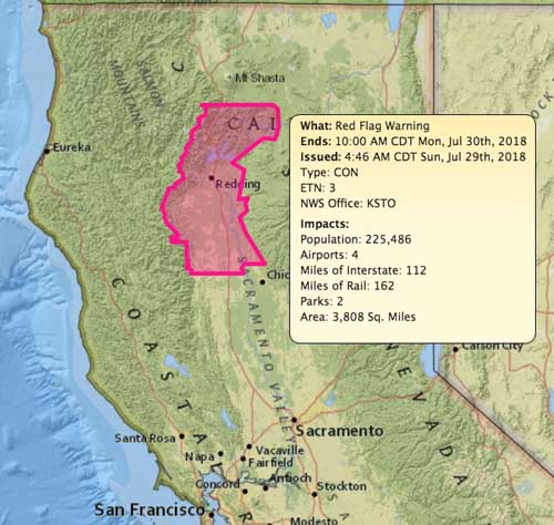
The area is under a Red Flag Warning again Sunday. The National Weather Service warns that strong winds up to 30 mph are possible in canyons in the late afternoon and overnight, but the forecast for the southeast part of the fire indicates the winds generally will be variable at 3 to 7 mph. Humidity in some areas could reach into the single digits while the temperature will be over 100 degrees. This hot, dry, trend will most likely last into mid-week.

Red Flag Warning, July 29, 2018 Redding
Red Flag Warning, July 29, 2018.

Death count rises to five in Carr Fire

The two firefighters killed have been identified

The number of fatalities on the Carr Fire rose to five Saturday July 28 when officials confirmed that two young children and their great-grandmother were found dead. James Roberts, 5, and Emily Roberts, 4, were stranded with Melody Bledsoe, 70, when the fire ran through the family’s property July 26 outside Redding, California.

To see all of the articles about the Carr Fire, including the most current, click HERE.

That same day two firefighters were also killed at approximately 6:40 pm when a dramatic increase in fire behavior occurred on the east side of the Carr Fire. Entrapped in a burn over were a call when needed contract dozer operator, Don Ray Smith, 81, of Pollock Pines and Redding fire Inspector Jeremy Stoke who had been with the Fire Department since 2004.

Also on July 26 three firefighters from Marin County were injured on the fire. They were treated at a hospital in Redding for burns to the ears, face, and hands, the department’s release said. One is receiving additional evaluation at the UC Davis Burn Center.

Our sincere condolences go out to the families, friends, and co-workers of these eight victims.

Update on Southwest Oregon fires

Here is a VERY brief update on the wildfires burning in Southwest Oregon.

On the map above the red dots are the most recent, representing heat detected by a satellite at 3:31 a.m. PDT July 28, 2018.

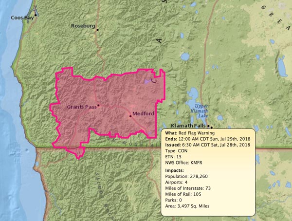
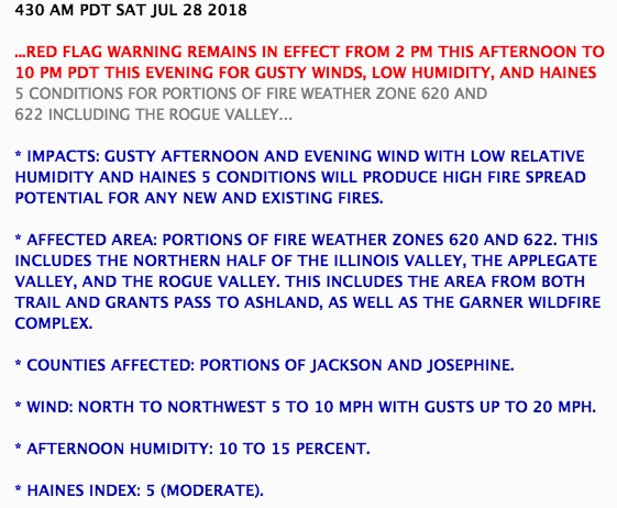
The area around Bend and Medford is under a Red Flag Warning Saturday for low relative humidity, gusty winds, and unstable atmospheric conditions.

Red Flag Warning
Red Flag Warning, July 28, 2018.
Red Flag Warning
Red Flag Warning, July 28, 2018.