Press Democrat wins Pulitzer Prize for coverage of North Bay wildfires

Nine years ago the Los Angeles Times also won a Pulitzer for their series of “Explanatory Reporting” articles about the state of wildland fire management.

Above: Map showing the location of wildfires north of San Francisco, October 18, 2017. The Press Democrat’s offices are in Santa Rosa.

(Originally published at 12:33 p.m. MDT April 21, 2018)

The staff of The Press Democrat has won the Pulitzer Prize for Breaking News Reporting for their coverage of the huge wildfires north of San Francisco in October, 2017.

Here is an excerpt from one of the 10 articles that were submitted to the Pulitzer jury, titled, “Firestorm Nightmare: How we covered the early hours of California’s most destructive fire”. The article begins with the perspective of Kent Porter, a skilled photographer who has covered numerous wildfires in California.

ABOUT 10 P.M., SUNDAY, OCT. 8 » As the wind howls outside his Windsor home, photographer Kent Porter turns on his scanner and hears crews talking about a brush fire 13 miles away off Tubbs Lane on Highway 128 near Calistoga. He grabs his gear and takes off.

As he passes over Mark West Springs and Petrified Forest roads, he can see the glow of fire in the hills. “The wind was just going crazy,” he said later. “Grass was burning. Vineyards were burning. Power poles were going back and forth, and electrical lines were sparking. It was pandemonium.”

10:42 P.M. » One of Porter’s first photos is a ghostly image of a firefighter racing through the yard of a home near the origin of the Tubbs fire. The flames would soon begin devouring rural homes in the valleys bordering Napa and Sonoma counties, racing west toward the region’s largest city. “This thing is going all the way to Santa Rosa,” a fire official tells Porter.

11:50 P.M. » Porter sends a text message to Managing Editor Ted Appel: “Ted this is going to be in Santa Rosa in a few minutes. I strongly suggest you get a reporter out.” Appel begins waking up reporters and preparing the first story.

The fire burned into Santa Rosa, the city in which The Press Democrat is based and the home for many of their employees.

The 10 articles can be read at the Pulitzer website.

The New York Times, which was also considered for a Breaking News Pulitzer for their coverage of the mass shooting in Las Vegas, wrote about The Press Democrat:

The firestorm lasted 30 days, killing 40 people and destroying more than 6,100 homes. [Managing Editor Ted] Appel recalls an exhausting grind — part war zone, part marathon — that engulfed every member of his staff. The line between duty and safety soon blurred: Evacuated reporters slept in the newsroom, dogs and children ran between the desks.

“This wasn’t just a big news story for us,” Mr. Appel said. “This happened to people we knew, it happened to our town.”

The caption for the photo above: “Staff members of The Press Democrat, from left, Randi Rossmann, Julie Johnson, Martin Espinoza, JD Morris, Christi Warren and Mary Callahan, celebrate winning the Pulitzer Prize for Breaking News Reporting for the coverage of the October fires in Sonoma County. Credit Kent Porter/The Press Democrat”

Nine years ago a series of articles about wildland fire won a Pulitzer Prize for authors Bettina Boxall and Julie Cart of the Los Angeles Times. The articles about the state of wildfire management were extremely well written and exhaustively researched, due in part to their Freedom of Information Act request for cartons of U.S. Forest Service records.

The Pulitzer board, making the award in the Explanatory Reporting category, called the series a “fresh and painstaking exploration into the cost and effectiveness of attempts to combat the growing menace of wildfires.”

Fire Chief finds charred sky lantern on his roof

charred burned sky lantern fire illegal
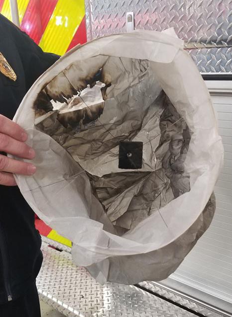
Chief of the International Falls, MN Fire Department, Adam Mannausau, displaying an illegal sky lantern that landed on the roof of his house. Photo: International Falls FD.

When the Chief of the International Falls Fire Department was backing out of his driveway last week in Minnesota he spotted something on his roof that was not supposed to be there. Chief Adam Mannausau discovered it was a charred sky lantern.

These dangerous devices use burning material to loft a small paper or plastic hot air balloon into the air. The perpetrator has no control over where it lands. Usually the fire goes out before it hits the ground, but not always. Sometimes the envelope catches fire while in flight. Numerous fires have been started on the ground by sky lanterns. Even if they don’t ignite a fire, they leave litter on the ground. Metal parts have been picked up by hay balers causing serious problems when fed to livestock

Sky lanterns are illegal in at least 30 states, including Minnesota.

sky lantern launch fire dangerous
File photo of a sky lantern.
Sky lanterns launch hundreds fire wildfire dangerous
Sky lanterns are sometimes launched by the hundreds at organized events. File photo.

Moffat Fire burns hundreds of acres north of Lone Pine, CA

Above: Moffat Fire, April 19, 2018. Photo: CAL FIRE San Bernardino Unit.

(UPDATED at 9:43 a.m. PDT April 21, 2018)

CAL FIRE reports that more accurate mapping determined that the Moffat Fire burned 1,265 acres.

****

(UPDATED at 12:12 p.m. PDT April 20, 2018)

CAL FIRE reported Friday morning  that the Moffat Fire near Lone Pine, California has burned 1,050 acres. There was no increase in size overnight.

****

(Originally published at 6:24 p.m. PDT April 19, 2018)

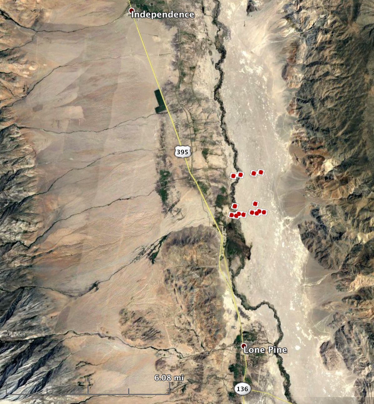
A fire that started Thursday afternoon grew to approximately 300 acres five miles north of Lone Pine, California. The fire is east of Highway 395 which for a while was closed in both directions. Later it was open but with escorts.

Lone Pine is 100 air miles northeast of Bakersfield, California.

The name of the fire was originally “Spillway”.

Moffet Fire
Map of the Moffet Fire at 1:51 p.m. April 19, 2018.

Officials confirm 23 homes destroyed in 117 Fire

Firefighters have slowed the spread of the 41,000-acre “MM 117 Fire” between Colorado Springs and Pueblo. The name comes from the mile marker on Interstate 25 near the point of origin.

The early reports indicated that 10 structures had burned, but officials have revised that to 23 residences, with 7 of them being unoccupied.

The state requested the Rocky Mountain Area Type 2 Incident Management Team Black, with Incident Commander Mark Hatcher, to manage the fire. They assumed command at 6 a.m. today (Thursday).

When the fire started Tuesday the wind was far too strong for any aircraft to assist firefighters, but Wednesday brought more favorable conditions allowing several contract air tankers and military helicopters to drop retardant and water.

Map 117 Fire
Map of the 117 Fire, April 19, 2018.


Time-lapse of Colorado fires detected by satellite

Posted on Categories UncategorizedTags ,

This is a time-lapse of wildfires in southeast Colorado detected by the fire temperature sensor on the GOES 16 satellite between 1700 UTC April 17 and 0400 UTC April 18. The fire near the arrow is the 117 Fire between Colorado Springs and Pueblo. At the lower right a fire can be seen burning from Colorado into Stanton and Morton counties in Kansas. Several other fires can also be seen. The fires were pushed by very strong winds that stirred up clouds of dust.