117 Fire burns structures south of Colorado Springs

The sheriff’s office reports 10 structures have burned

Above: satellite photo showing the location of the 117 fire south of Colorado Springs. The red dots on the map represent heat detected by a satellite at 2:30 p.m. MDT April 17, 2018.

(UPDATED at 11:33 a.m. MDT April 18, 2018)

A more accurate estimate of the size of the 117 Fire between Colorado Springs and Pueblo puts it at 41,000 acres. Military helicopters, Chinook and Blackhawks, are assisting firefighters by dropping water.

A deputy sheriff said he was driving at 35 mph near the fire Tuesday and it was moving faster than he was.
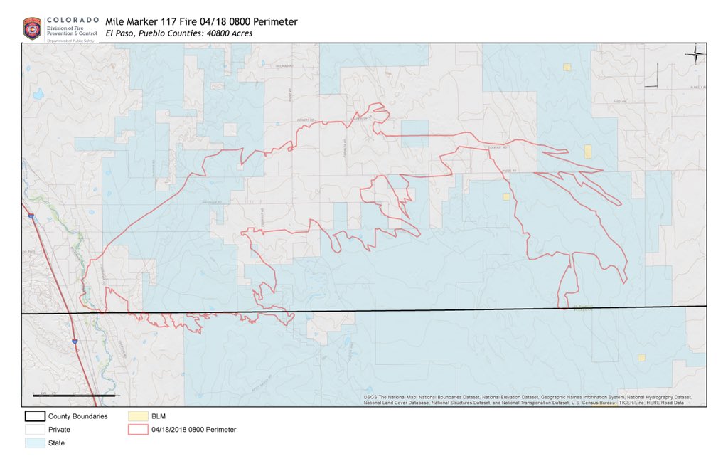
Map of the 117 Fire
Map of the 117 Fire, at 8 a.m. MDT April 18, 2018

***

(UPDATED at 7:15 a.m. MDT April 18, 2018)

The El Paso County Sheriff’s office reported Wednesday morning that the 117 Fire between Colorado Springs and Pueblo, Colorado has burned an estimated 60,000 acres. The fire is still active in El Paso and Pueblo Counties but the wind speeds recorded at Fort Carson and Pueblo have decreased Wednesday morning — calm to five mph, compared to gusts of 50 to 80 mph Tuesday afternoon.


The wind on Tuesday was too strong for helicopters, air tankers, or Colorado’s Multi-Mission Aircraft to fight or even map the fire, but officials hope to get the MMA into the air this morning to give firefighters a better idea of the scope of the blaze.

****

(Originally published at 9:38 p.m. MDT April 17, 2018)

The 117 Fire has burned at least 4,000 acres about halfway between Colorado Springs and Pueblo, Colorado. The sheriff’s office reports 10 structures have burned. The fire started Tuesday along the Interstate 25 corridor about halfway between Colorado Springs and Pueblo. It spread quickly pushed by very strong winds.

There are few public weather stations near the fire but a station north of Pueblo recorded sustained wind speeds between 9 a.m. and 2 p.m. of 45 to 60 mph gusting at more than 80 mph. The minimum relative humidity was four percent. A weather station at Fort Carson south of Colorado Springs had winds of 30 to 40 gusting above 50 mph during the same period.

Until about 2 p.m. the wind was out of the southwest. The extreme speed created a very narrow fire that grew seven miles to the northeast by 2:30 p.m. Monday. Later in the afternoon the wind shifted to come out of the south and then the southeast and east. The shifting direction could cause firefighters to be caught unexpectedly near a rapidly advancing flank or head of the fire.

The El Paso County Sheriff’s office announced mandatory evacuations on their Facebook page.

There are reports that a law enforcement patrol vehicle burned and a fire engine was damaged by the quickly spreading fire.

The county declared the fire a disaster and they are in negotiations with the state to take over the fire.

The area was under a Red Flag Warning Monday and Monday evening. The forecast for the 117 Fire area Monday night calls for 20 mph winds gusting to 30-40 decreasing to 7 mph by 8 a.m. Tuesday. The high temperature Tuesday should be 59 degrees with 13 percent relative humidity  along with much calmer winds.

The wind on Monday was far too strong to allow any helicopters or air tankers to take suppression action on the fire, but that will probably change on Tuesday.

Oklahoma wildfires: 34 Complex slows, Rhea continues to spread

The two fires have burned more than 316,000 acres and 63 homes

Above: Map of the Rhea Fire, April 16, 2017. Incident Management Team.

Two wildfires that are 20 miles apart in Western Oklahoma have burned more than 316,000 acres and 63 residences.

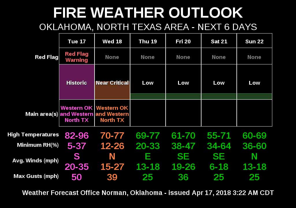
The spread of the 34 Complex of Fires north of Woodward has slowed, but the strength of the firelines could be tested Tuesday with fire weather conditions called “historic”. The forecast includes winds out of the southwest at 35 to 45 mph with gusts up to 65 along with humidities as low as 7 percent.

map rhea 34 complex wildfires
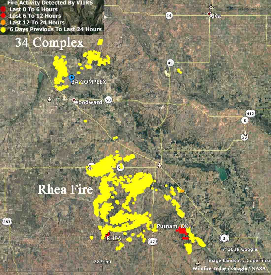
Map showing heat detected by a satellite on the 34 Complex and Rhea Fires in Western Oklahoma, current at 2:22 a.m. CDT April 17, 2018. The satellite flying over the area twice a day can’t detect heat in light vegetation that burns and then cools before the next pass.

The same conditions will affect the huge Rhea Fire 20 miles south of the 34 Complex. Some areas of the 248,589-acre fire are quiet, but it was still spreading Monday east of Putnam (shown in red on the map above). Those active areas could be challenging for firefighters with the extreme weather predicted for the area Tuesday and Tuesday night.

Fire weather april 17, 2018 dangerous wildfire
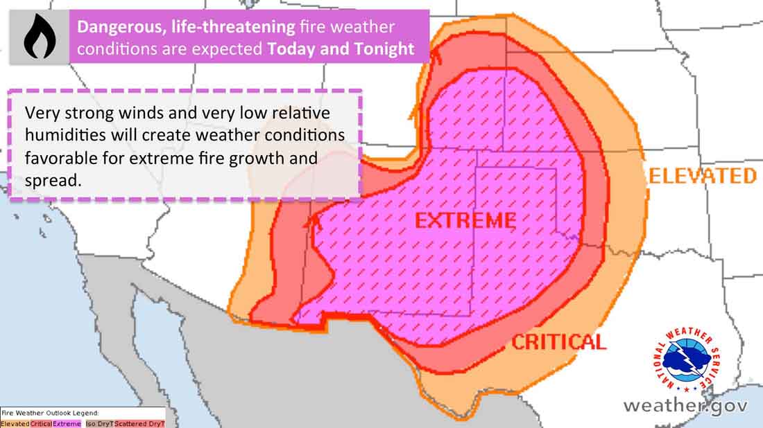
Fire weather conditions predicted for Tuesday and Tuesday night.
Rhea Fire
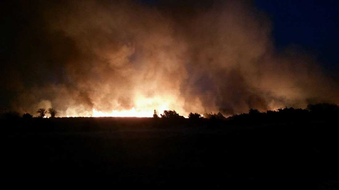
Rhea Fire, April 16, 2018. Oklahoma Forestry Services photo.

“That fire behavior forecast should scare the hell out of you”

Dangerous wildfire conditions Tuesday in Southern Plains

Above: Wildland fire danger for Tuesday, April 17, 2018

The wildland fire danger on Tuesday is just that — dangerous. Weather forecasters are saying the strong winds, dry vegetation, and relative humidity that in some areas will drop into the single digits could be life-threatening fire weather. These extreme conditions, called “historic”, will continue into Tuesday night in most areas.

In the video below Deb Beard, the Trainee Incident Commander on the 67,000-acre 34 Complex of Fires in western Oklahoma, warned firefighters at the Tuesday morning briefing that “the fire behavior forecast should scare the hell out of you”.

Fire weather april 17, 2018 dangerous

Red Flag Warnings are in effect in Colorado, Kansas, Oklahoma, Texas, New Mexico, and Arizona.

Fire weather april 17, 2018 dangerous wildfire red flag warning
Red Flag Warnings April 17, 2018,

Firefighters make progress on Bluewater and Dienier Canyon Fires in New Mexico

Above: Operations Section Chief Rocky Gilbert. Screenshot from Incident Management Team video.

On Monday firefighters were able to hold some of the perimeter on two fires in western New Mexico, the Bluewater and Diener Canyon Fires, which have burned 2,532 and 6,682 acres respectively.

Soon after it started April 12 there were reports that the Diener Canyon Fire started from an escaped prescribed fire on the Cibola National Forest. Then on April 15 the Forest Service issued a statement saying “the exact cause of the Diener Canyon Fire is currently being investigated.” Today, April 16, the Forest Service is reporting that “fire investigators have determined that multiple spot fires from the Redondo Prescribed Burn started the Diener Canyon Fire”.

The Diener Canyon Fire is burning on Mount Sedgwick within an old fire scar from 2004. The Bluewater fire is approximately 4 miles north of the Diener Canyon Fire on Salitre Mesa.

Sunday firefighters continued the burnout operation on the east flank of the Diener Canyon Fire, along Forest Road (FR) 425. The burnout resulted in a wide containment line, as six to ten inch flames slowly consumed light to moderate forest vegetation. This line is designed to prevent any fire from moving to the east toward Bluewater Village and La Jara subdivision.

Fire crews completed confinement lines on the northwest corner of the Bluewater Fire, stopping movement of fire toward Bluewater Acres, but fire remained active in windrows of uprooted juniper trees on the north side of the fire. A heavy helicopter dropped water on burning vegetation, assisting firefighters as they suppressed the flames.

Monday crews planned to continue the burnout along FR 425 east of the Diener Canyon Fire, bringing the containment line south to tie in to FR 480. Firefighters will patrol and mop up along FR 178, and may use aerial ignition to clean up unburned areas if necessary, weather permitting. Structure Protection crews will continue assessing prevention needs. Fire is still active on the northeast corner, and helicopters will be used to keep the fire in check, weather permitting.

Below is a video update for both fires by Operations Section Chief Rocky Gilbert. It was posted on Monday, April 16.

Red Flag Warnings in southern plains and southwest on Monday

Some of the areas will have similar conditions on Tuesday

Most of the southern plains and the southwest will be under Red Flag Warnings on Monday, April 16. The strong, gusty winds and low humidity will continue into Tuesday for many of the areas. The eight states affected are California, Arizona, New Mexico, Texas, Oklahoma, Kansas, Colorado, and Wyoming.

Utah miraculously avoided the weather that three of its neighbor states are experiencing. Forecasters there often march to a different drummer regarding Red Flag Warnings.

The Red Flag Warning map was current at 10 a.m. MDT on Monday. Red Flag Warnings can change throughout the day as the National Weather Service offices around the country update and revise their forecasts.

Rhea Fire in Oklahoma grows to 241,000 acres

A civilian fatality was reported Saturday

Above: Map of the Rhea Fire in Western Oklahoma, current at 2 p.m. CDT April 15, 2018

The Rhea Fire in Western Oklahoma has long since exceeded the 100,000-acre threshold to qualify as a “mega fire”. The most recent size estimate puts it at 241,280 acres.  More than 500 firefighters are assigned along with three large air tankers, two type 1 helicopters, four single engine air tankers, two CL-415 scooping air tankers, an air attack plane, and two National Guard helicopters.

Dewey County Sheriff Clay Sanders reported Saturday that a female died in her vehicle at a residence near Seiling. He did not release her name, pending family notifications.

On Saturday strong winds out of the northwest pushed the fire through drainages toward Thomas and Fay in Dewey county.

Firefighters will not get a break from the weather anytime soon. The forecast calls for escalating fire danger through Tuesday with the potential for temperatures back up into the 90°’s and relative humidity values below 15 percent in western Oklahoma and below 25 percent along the I-35 corridor. Sustained southwest winds up to 30 mph and gusts of 40-45 mph will again present a very concerning fire behavior scenario with extreme rates of fire spread anticipated.

Firefighting resources from across the country are arriving to assist the local agencies and departments, not only in Oklahoma, but also in New Mexico and Arizona where wildfire activity is increasing.