Prescott Division Chief provides more information about fatalities at Yarnell Hill Fire

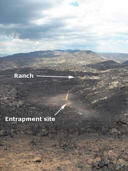
Yarnell Hill Fire Fatality Site, Photo by Joy Collura, labels by Wildfire Today
Fatality site photo, looking east. Photo by Joy Collura (used with permission), labels by Wildfire Today

Prescott Fire Department Division Chief Darrell Willis on Tuesday escorted members of the media to the site on the Yarnell Hill fire where 19 members of the Granite Mountain Hotshots were killed June 30. John Dougherty, an investigative reporter who has written for the New York Times, was there and recorded these videos of Chief Willis’ briefing. They are embedded here with his permission. John also wrote an article about his visit to the site.

The first video is the Chief providing his understanding of what happened, and in the second he takes questions from the reporters.

In the photo below of the entrapment site, which is looking toward the west, the road was punched in by a dozer after the incident to facilitate the removal of the bodies, which were at the end of the road. The photo was taken by Wade Ward of the Prescott FD, and is used here with permission.
Continue reading “Prescott Division Chief provides more information about fatalities at Yarnell Hill Fire”

Hotshot quiz

The Christian Science Monitor has put together a quiz titled “Could you be a hotshot?” It’s kind of a pain to take since each of the 20 questions requires two page reloads. Some of the questions are worded very badly, and some of the “correct” answers are questionable. And it does not work well with the Chrome browser — Internet Explorer is recommended.

Of course it’s ridiculous to imply that if you get a good score you “could be a hotshot”. But if you want to try it, you can find it here.

Wyoming: Fairfield Fire

(UPDATED at 3:26 p.m. MDT, July 24, 2013)

The incident management team released this information Wednesday afternoon:

Lander, Wyo. (July 24, 2013) – A public meeting for the Fairfield Fire will be held at 7:00pm this evening at the Lander Middle School, 755 Jefferson St., Lander, Wyo. This meeting will be an opportunity for the public to learn what actions have been taken on the fire thus far and what the plan ahead is.

Following an infrared flight last night, a more precise perimeter was able to be determined. This allowed the Rocky Mountain Incident Management Team, who took over command of the fire late yesterday, to develop a more accurate map. The fire is 15 percent contained with a total size of 1,909 acres. The cause of the fire remains under investigation by a Fremont County firefighter and Forest Service officials.

Some local initial attack resources have been released from the fire. A total of 138 personnel are currently on the fire along with 6 single engine air tankers, 2 light helicopters, and 2 heavy helicopters.

The National Weather Service has established a “decision support” web page for the fire.

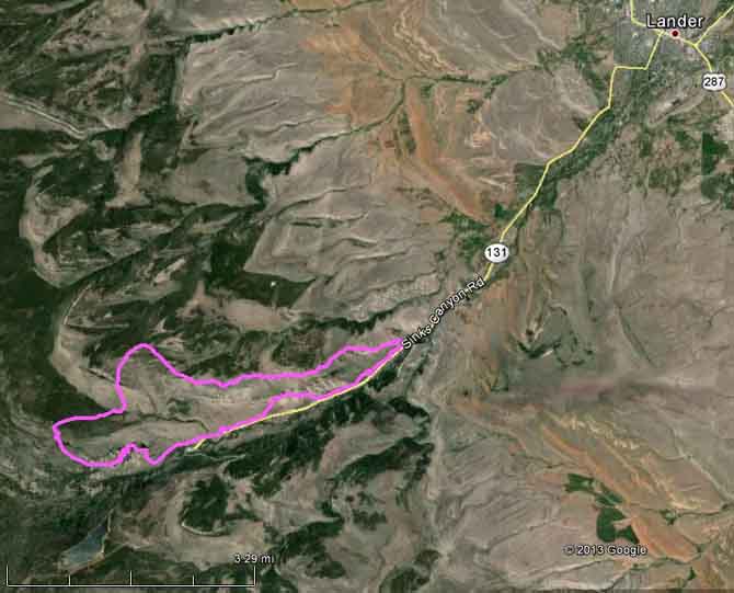
Map of Fairfield Fire MDT, July 24, 2013

The Fairfield Fire continued to spread on the west side over the last 24 hours as it climbed into the higher elevations, finding more continuous stands of timber.

The weather forecast for Wednesday predicts weather similar to Tuesday’s, with easterly up canyon winds at  5 to 10 mph, 15 to 20 percent relative humidity, 30 to 65 percent cloud cover, and a chance for thunderstorms with little or no rain.

Continue reading “Wyoming: Fairfield Fire”

New training video for handline construction


The Connecticut Department of Energy and Environmental Protection and Middlesex Community College have recently completed a new training video designed to assist local fire departments when training their personnel in the construction of handline, or fireline. The 10-minute video is titled “Handline Construction for Forest Fire Control”.

It is geared toward fireline construction in eastern vegetation, but the principles apply in other areas as well. It was funded by the U.S. Forest Service with the understanding that it could be used in other states.

The film is skillfully written and produced and should be helpful when training new firefighters.

In one section the narrator mentions that when initial attacking a fire you should walk around it to size it up, but wisely adds, “If the fire is rapidly moving, don’t go around the head.”

The video is unique in that it shows firefighters working adjacent to an actual fire, which may be a prescribed fire, but it has flames, nonetheless.

A very long time ago I and several other firefighters on the Cleveland National Forest demonstrated in a training film the use of hand tools to construct fireline in southern California brush. It was titled “Hand Tools for Wildfire” and has no doubt disappeared from shelves in training rooms, thankfully. My role in the film was to demonstrate a “golf swing” while using a brush hook, a technique in which you swing the hook like golf club and impact the target on the way up, after you would have hit the golf ball…if you were using a brush hook to play golf. Most firefighters today probably don’t know what a brush hook is. Even back then hooks were being replaced by chain saws. When I ran a saw on the El Cariso Hothshots, it was a Homelite Super XL.

Brush Hook
Brush Hook

Red Flag Warnings and smoke distribution, July 22, 2013

The map below shows the distribution of smoke from wildfires in the United States and Canada. For much more information about smoke and dust in the air today, visit NOAA’s text description, which is perhaps more than you want to know.

Wildfire smoke map
Map showing the distribution of wildfire smoke at 10:52 a.m. MDT, July 22, 2013
Red Flag Warnings wildfire
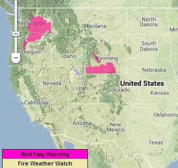
Red Flag Warnings, July 22, 2013

Red Flag Warnings and Fire Weather Watches for enhanced wildfire danger have been issued by the National Weather Service for areas in Washington, Oregon, and Wyoming.

****

The Red Flag Warning map above was current as of 11:35 a.m. MDT on Monday. Red Flag Warnings can change throughout the day as the National Weather Service offices around the country update and revise their forecasts. For the most current data, visit this NWS site.