CA: BTU Complex, July 9 update

Posted on Categories Uncategorized

Update: 0900 PT-

Wildfire Today received a call from a local resident who used our “Call Me” button. He said the fire crossed the West Branch of the Feather River (which runs north and south in this area) but the spots across the river were picked up by aircraft and firefighters. He said the fire is being pushed to the south now by a steady 15 mph wind, which would mean it will be moving parallel with the river.

The weather forecast for today:

Paradise (at the fire, elevation 1,715′)
Temp: 104
Winds: NE shifting to NW 5-7
RH: 12%

Oroville (12 miles south of the fire, elevation 190′)
Temp: 107
Winds: N shifting to W and then NW 7-9
RH: 10%

=========================
The Camp fire, part of the BTU (or Butte) Lightning Complex, slowed last night after burning approximately 50 homes in Concow, California yesterday. Evacuations are in effect for portions of Concow and Paradise displacing an estimated 9,500 14,000 people.

Monday night between 8 and 10 p.m., firefighters began a firing operation out ahead of the fire, between the fire and Concow. CalFire-Butte County Capt. Scott McLean said the firing was going well, until an unexpected change in the weather occurred after midnight. Strong down canyon winds and a drop in the relative humidity from 43% to 21% caused spot fires far ahead of the firing operation.

McLean said:

We had to try something; the fire was going to get there anyway.

On Tuesday the fire reached Concow and burned at least 50 homes. We don’t fault the firefighters…. we will take the spokesperson at his word, that the fire would have reached Concow anyway. The strong winds Monday night and Tuesday contributed to the extreme fire behavior that caused the fire to burn all the way to the outskirts of Paradise.

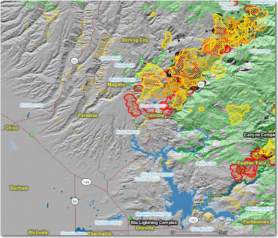
The map below shows heat, in red, orange, and black, detected by satellites last night, with the red areas being the most recently burned. The yellow lines are the latest perimeters uploaded by the incident management teams. Click on the map to see a larger version.

Wall Street Journal writes about Big Sur fire blog

Posted on Categories Uncategorized

The Wall Street Journal deviated from their usual fare of business articles to write about a blog that was created on July 3 to provide information to Big Sur residents about the Basin Complex fire which surrounded the community. Here is an excerpt:

In Big Sur, Web Site Run by Resident Is Key Data Source
By STU WOO
July 9, 2008; Page A3

BIG SUR, Calif. — As a wildfire that has ravaged 80,000 acres threatens their community, residents waiting for news about their homes and businesses here aren’t waiting for word from fire officials at nightly meetings or from newspapers in the morning.

Instead, they are heading online to SurFire2008.org.

The Web site and blog are run by Lisa Goettel, a temporarily homeless Web designer whose move to a new Big Sur house about 150 miles south of San Francisco was derailed by the wildfire, which was 18% contained Tuesday. Ms. Goettel runs the site out of a coffee shop with free wireless Internet in Carmel-By-The-Sea, about 25 miles north of Big Sur. She depends on five residents and businesspeople who remain in Big Sur — defying mandatory evacuation orders — for on-scene reports.

The site has become a must-read for Big Sur residents, the media and even fire officials. It routinely scoops fire officials and newspapers. The site also provides displaced residents a space to find temporary employment or shelter. The blog has already received 73,000 hits since it went up on July 3.

After the evacuation order, Mayra Reyes and her father spent a couple of nights at a hotel, which charged them $40 a night. But then they visited the SurFire2008 site and found good Samaritans who had posted an offer to house Big Sur residents. “It was very helpful,” said Ms. Reyes.

Retired lawyer Sam Goldeen said he checks the site three or four times a day. “It’s all there is,” Mr. Goldeen said. “These nightly meetings don’t talk about [specific] homes and areas.” Generally, he said, the fire chief doesn’t know “because he’s concerned about the big picture, and he should be.”

The blog is updated several times a day by Ms. Goettel and correspondents like Stan Russell, the executive director of Big Sur’s chamber of commerce who has been bunkered in the Post Ranch Inn here for the past week. The 52-year-old Mr. Russell, armed with a digital camera, a pair of binoculars and a laptop, walks around the ash-covered 100-acre property to take pictures and report on what he can see from the hilltop site. He sends a report to Ms. Goettel, who puts it online.

“The way we are doing it is certainly unique,” Mr. Russell said. “I think people are going to look at us as a model…at how fast and efficiently we self-organized.”

BTU Complex: 50 homes burn in Concow

At least 50 homes burned Tuesday in the city of Concow, California as the BTU (or Butte) Lightning Complex swept through communities 20 miles east of Chico. The entire east half of the city of Paradise, a city of 26,000, is under evacuation orders, and some areas of Magalia have also been evacuated.

If the weather forecast is accurate, Paradise and Magalia are under a severe threat from the fire. Firefighters hope to stop the fire at the West Branch of the Feather River just east of the city.

This is the third time in the last few weeks that Paradise has had a bulls eye painted on it by fires heading in their direction.

HERE is a link to a very interesting map of the fire in the area made by the newspaper in Chico, the Chico Enterprise Record. This is an amazing use of Google Maps. You might call it groundbreaking. There is a ton of information there—I hope the data is accurate. Click on the icons on the map to get details.

Record high temperatures as high as 115 in the valley on Tuesday contributed to the extreme fire behavior. Foothill temperatures were expected to be in the 90s on Tuesday.

The Weather forecast for Paradisc, CA: (note that the maximum relative humidities at night only go up to 30% and 26%)

Tuesday night: Areas of smoke. Clear, with a low around 79. Northeast wind between 10 and 15 mph, with gusts as high as 18 mph. RH 30%.

Wednesday: Areas of smoke. Sunny and hot, with a high near 110. North northwest wind between 5 and 10 mph. RH 10%.

Wednesday Night: Areas of smoke. Clear, with a low around 77. North wind between 7 and 13 mph. RH 26%

Thursday: Areas of smoke. Sunny and hot, with a high near 108. Northeast wind 6 to 8 mph becoming west. RH 11%.

CA: Oregon firefighter drowns

Posted on Categories Uncategorized

An off duty firefighter drowned yesterday in the Trinity River in northern California.

The Times-Standard

A wildland firefighter from Oregon who was fighting the local fires drowned yesterday after visiting the Trinity River on his day off, the Humboldt County Coroner’s Office said.

The firefighter, who was in his 30s, was visiting the river near Willow Creek, said Deputy Coroner Charles Van Buskirk.

”We’re working currently to notify his family,” Van Buskirk said late last night.

According to a press release, the Humboldt County Sheriff’s deputies responded to Kimtu Beach in Willow Creak at about 4:30 p.m. and found about a dozen people searching for the victim.

Deputies were assessing the situation when they learned the victim had been pulled from the water near Patterson Road. Resuscitation efforts were unsuccessful.

The firefighter was employed by a contract wildland firefighting company. Witnesses told deputies the victim attempted to swim across the river in a T-shirt and his Nomex pants. About halfway across, the man turned around and tried to return to shore.

The current began to carry him down the river and he seemed to panic, witnesses said. Another swimmer attempted to help the man, but had to swim to shore after approaching the swift current and rocks. Witnesses saw the victim go underwater and his body was recovered approximately 20 minutes later.

The decedent’s name is being withheld pending the notification of the next of kin.

Our sincere condolences for the family of this firefighter.

California fires: a record setting year?

Posted on Categories Uncategorized

Acres burned in California on CalFire jurisdiction lands by year:

1936– 756,696
2008– 630,886 (to date)
2007– 434,667
2003– 404,328
2006– 222,896

The numbers are provided by CNN. They did not say if these are the top 5 years, but did state that the previous high was the 1936 figure. I assume there were several other years when more than 222,896 acres burned that are not listed here, for example, 1970, when the Laguna fire east of San Diego was 165,000 acres. Many other large fires burned in 1970 as well, leading to the development of the Incident Command System.

Update @ 1400:
A little research shows that in 1985, 235,400 acres burned on the Los Padres NF alone, due mostly to the Wheeler and Gorda-Rat fires.

Update @ 1440:
More research shows that the numbers provided by CNN are only for fires on CalFire jurisdiction. Geeze. Too bad they didn’t mention this little detail. HERE is a link with CalFire numbers by year.

CA: BTU complex, more evacuations

Posted on Categories Uncategorized

The BTU complex of fires east of Chico made some big runs during the night and this morning, according to a local who called Wildfire Today using the “Call Me” button on the left side of this page. He said evacuations of the northeast side of Paradise and the southeast side of Magalia are in progress. The smoke, he said, that flows down the Feather River drainage and settles in the low lying areas at night has been very intense.

Information about the evacuation of part of Paradise can be found HERE.

According to the Geographic Area Coordination Center, an evacuation of Concow is ongoing, affecting 300 homes and 800-1,000 residents. The local media is reporting that at 8 a.m. this morning extreme fire behavior caused fire crews to be pulled off the fire line, due, in part, to 30 mph northeast winds.

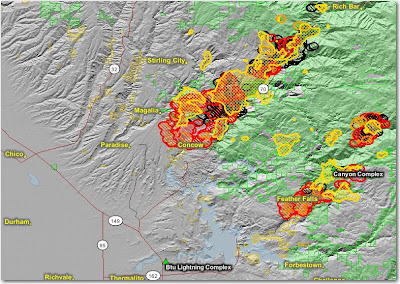
Below is a map that was updated this afternoon. It shows heat, in red, orange, and black, detected by satellites, with the red areas being the most recently burned. The yellow lines are the latest perimeters uploaded by the incident management teams. Click on the map to see a larger version.