CA: Piute fire July 6

The fire is 21,478 acres and is 26% contained.

From Kern County FD:

On Saturday, the fire moved actively toward the east and northeast driven by strong southwest winds and further growth is expected in the same area today. The fire perimeter now extends into the BLM Bright Star Wilderness. The fire also continues to move slowly down slope along the western and northern perimeters. Firefighters plan to burnout fuels along the southeastern fire line. Yesterday, the fire increased 2,468 acres.

There was active burning on the eastern side as the head of the fire fingers into sparse desert fuels in the Bright Star Wilderness. The fire has spread into Cortez and Bright Star Canyons. All structures continue to be protected.

Hand crews and dozers are constructing indirect fire lines on the northern and western ridges. Firefighters continue to reinforce fire line along the flanks of the southern perimeter.

Precautionary evacuation notices were delivered to residences in the Kelso Valley area by the Kern County Sheriffs Office and Search and Rescue Team.

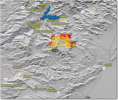
The map below shows heat, in red, orange, and black, detected by satellites last night, with the red areas being the most recently burned. The yellow lines are the perimeters uploaded by the incident management teams yesterday. Click on the map to see a larger version.

California: Basin fire, July 6

Posted on Categories Uncategorized

The Basin Complex and the Indians fires have now been combined into a unified command.

The fire activity on the Basin fire was slowed somewhat yesterday along the coast under the influence of the marine layer, but it was very active on the north and south sides. The fire is 71,285 acres and is 5% contained.

South side: Firefighters continue to make progress on the fireline going down the ridge from the North Coast Ridge trail south towards the Square Black Rock south of Esalen. Slow progress is still occurring on the Ridge trail toward the Rodeo Flats Trail, which will connect the fire to the Indians fire. To improve radio communications, a radio repeater will be placed on a boat.

North side: Last night firefighters were expected to begin firing from Andrew Molera State Park north along the Old Coast Road towards the Little Sur river, and eventually to a dozer line on Mescal Ridge. The fire last night was about 2 miles south of the ridge. If this plan works, and subsequent firing along Mescal Ridge is successful, this would tie off the northwest corner of the fire. Yesterday the DC-10 air tanker made some drops on Mescal Ridge.

East side: There was some activity on the east side, but it is still 1.5 to 2 miles away from Tassajara.

CA: Piute Fire Update, July 5

The Piute Fire, south of Isabella Lake and east of Bakersfield, last night crossed the Piute Mountain Road again at around 9:30 p.m. Crews worked through the night and used natural barriers to stop the spread. Firefighters previously contained a run across the road on Friday morning. The fire crossed over a 1-mile section of the Pacific Crest Trail north of Piute Mountain Road and 2 miles east of Claraville Flat. On the northeast corner, the fire moved into the Bright Star Wilderness in the Cortez Canyon area.

The fire continues to move east towards the Kelso Valley area and similar fire movement is expected today. Steep terrain on the western and northern portions of the fire is hampering containment efforts. The fire is 19,010 acres and is 18% contained.

The map was updated today at 1:00 p.m.

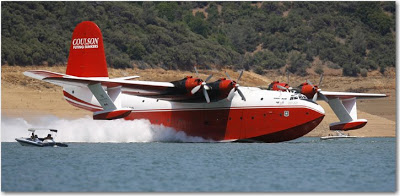
Martin Mars reloads

Martin Mars scooping
Hawaii Martin Mars scooping water at Lake Shasta.

I wonder what kind of wake the Martin Mars creates when it skims along a 3-mile stretch of Lake Shasta filling its 7,200 gallon tank at 80 miles per hour? It probably makes the lake a little choppy for the water skiers for a few minutes.

Always film posterOn Friday, it did this 20 times, reloading about every 25 minutes, dropping the water on the nearby 16,700-acre Motion fire. That is a damn good turn around time for an air tanker. The pilots have the option of dropping plain water on the fires, or mixing class A foam or fire retardant gel into the water.

Do you remember the opening sequence in the 1989 movie, the Steven Spielberg production with Richard Dreyfuss, Holly Hunter, and John Goodman that is centered around air tanker pilots? Turn up the sound when you play the 55-second clip below….it’s more fun that way.

One of the lines in the movie is still food for thought for firefighters.  John Goodman said to Richard Dreyfuss:

Pete, there ain’t no war here… And this is why you’re not exactly a hero for taking these chances you take. You’re more of what I would call a dickhead.

Some trivia about the movie, from Wikipedia:

The movie is set in the Kootenai National Forest in Montana, with some scenes filmed in and around Libby, Montana. Some 500 people from Libby were recruited for the movie as extras to act as wildland firefighters.

In the opening scenes the forest fires were created by Pathfinder Helicopter Inc.. They were hired by the Forest Service to burn some clearcuts near Libby that were filmed for the movie. The helicopter Pilot was Steve Tolle and the Ground Crew Manager was Jim Leighty.

The Libby airport was used to double as the Forest Service Headquarters in the movie.