California: Clover fire

Posted on Categories Uncategorized

The Clover fire, on the Sequoia and Inyo National Forests listed at 13,250 acres and 10% containment, has been less active the last two days.

Photo from the Clover fire

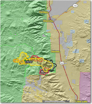
The map below shows heat in red detected by satellites last night. The perimeter as uploaded by the incident management team is in yellow.

California: Gallery, Basin, Indians fires update

Posted on Categories Uncategorized

On the north side of the Indians fire an evacuation order has been placed for the Arroyo Seco Drainage effective at 0800 hours on June 25.

The Gallery fire south of Big Sur, part of the Basin complex, has been very active the last few days. If it has not already, it almost certainly will merge with the Basin fire just to the north. As of last night the combined acreage was 13, 550 for the two fires. Evacuations are still in effect for the Partington Ridge area, and Hwy. 1 remains closed. The fire has consumed 16 structures and is burning in the tracks of the 1977 Marble-Cone fire which scorched about 165,000 acres.

You have to think about the possibility of the Basin complex burning into the Indians fire which is about 5-7 miles away. There is a 20-39% probability this will happen by June 30 if there is no suppression action in that area. I imagine that would disappoint Bill Molumby’s team that has struggled to obtain 71% containment of the 57,943 acre Indians fire. Having burned area on both sides of your fireline is disconcerting, to say the least.

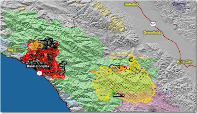
The map below shows heat in red detected by satellites last night. Click on the map to see a larger version.

Summary of northern California fires

Numbers for the lightning bust, as of noon today June 24, in northern California only:

Fires on federal jurisdiction:
Number of fires: 528
Acres burned: 8,347

Fires on state jurisdiction:
Number of fires: 455
Active fires: 101
Unstaffed fires: 73
Contained: 203
Acres burned: 52,346

Not all initial attack fires are reported

Total reported fires during the lightning bust in northern California: 983

Incident Management Teams committed in northern California only, as of 1300 today:

  • SHF – Lime Complex- T2 Kaage/ T1 Opliger
  • SHF – Iron Complex – T2 Swartzlander
  • SHF – Area Command Zimmerman
  • SHF – FUMT Ourada/Soper
  • LNF – Cub Complex – T2 Batten
  • LNF – Peterson – T1 Ruggiero
  • KNF- Siskiyou Complex – T2 Paul
  • PNF- Canyon Complex – T1 Pincha-Tulley
  • SRF – Ukonom/Orleans– T2 Lund
  • SRF – Hells Hat Complex – T2 Secrest
  • TNF – Yuba River Complex – T2 Joseph
  • TNF – American River Complex – T1 Summerfelt
  • SHU – Shasta Complex – T1 KERCHEN
  • BTU – Butte Complex – T1 Lewin
  • MEU – Mendocino Complex – T1 Waterman
  • LNU – Wild Fire – T1 Morris
  • ONC- NIMO – Gage
  • ONC – Order 1 T1 team staging SAC

Lessons Learned Center web site is up again

Posted on Categories Uncategorized

Wildfire Today reported yesterday that the Lessons Learned Center and the Incident Management Teams web sites had been hacked. They are both back up again according to Paula at the LLC:

We thank you for your patience throughout the weekend, and most of today, while our programmers worked to isolate a weakness within our database code. The weakness was exploited by a global attack, affecting over 510,000 WebPages, not directed at any one website. This code was identified and replaced, increasing our system security.

California Fuels and Fire Behavior Advisory

Issued June 21. Better late than never.
=====

Subject: Low live and dead fuel moistures, along with persistent drought, have created the potential for active to extreme fire behavior in many low to mid-elevation parts of the state.

Discussion: With the exception of the northwest corner of the state, most of California is experiencing drought conditions. Effects of lower than normal live and dead fuel moistures and localized sudden oak death are the focus of this advisory.

Concerns to Firefighters:
• Energy Release Components (ERC) at numerous weather stations in the affected Predictive Service Areas (PSA) are setting record highs; this is an indication of very dry fuels. Expect increased fire intensity and spread rates in these areas. Already this year several burnover situations have occurred. The fuels in these PSA’s are primarily grass and brush. A common denominator of fire behavior on tragedy and near-miss fires: Flare-ups generally occur in deceptively light fuels, such as grass and light brush.
• The combination of persistent drought in the South and record setting low March-May precipitation totals in the North has led to low live and dead fuel moistures. Expect fires to ignite easier and spread faster. During mobile attack in light fuels engine crews have found that it takes more time using additional water to knock down fire under these current conditions.
• Both live and dead fuel moistures are 3-6 weeks ahead of last year’s drying rates. Low 1000 hour fuel moistures have been evidenced by complete consumption on recent fires. Anticipate increased spread rates, spotting, and active nighttime burning. Link to extreme fire behavior video on the Indians fire in the Central Coast Mountains:
http://gacc.nifc.gov/oncc/predictive/fuels_fire-danger/LP_FIRE_BEHAVIOR_08.wmv
• Localized sudden oak death (SOD) has affected a number of oak species in southern California.
Fire behavior in areas affected with SOD is often more intense due to increased fuel loadings.

Mitigation Measures:
• Local and inbound fire personnel need to develop situational awareness of the conditions represented in this advisory. Details on site specific conditions regarding ERC’s, live and dead fuel moistures, and/or disease should be covered during briefings.
• Ensure firefighters have good anchor points, escape routes, and safety zones. Remember LCES.
• Consult the latest Fire Weather Forecasts, Monthly Fire Weather / Fire Danger Outlooks, Pocket Cards, and the recently updated California Fire Season Assessment (July-October) posted at:
http://gacc.nifc.gov/oncc/predictive/index.htm
http://gacc.nifc.gov/oscc/predictive/index.htm

Area of Concern:
The area of concern covers the following 6 PSA’s in California: Bay Area, Central Coast Mountains and Valleys, Mid Coast to Mendocino, Sierra Foothills, Sacramento Valley Foothills and the portion of the Northern Sierras below 3,000 feet elevation. A map showing the areas of concern described in this advisory can be found at:
http://www.nifc.gov/nicc/predictive/fuels_fire-danger/fuels_advisories.htm

Issued: June 21, 2008 Valid Until Further Notice
=========
HERE is a link to the document that includes a map.

(From FireNet)

California: Gallery, Basin, Indians fires

Posted on Categories Uncategorized

The Gallery fire, part of the Basin complex south of Big Sur, was very active yesterday. The Gallery fire is approximately 5,920 acres and is 10% contained. The Basin fire, which is north of the Gallery fire, is also part of the complex which totals 8,500 acres. However, in looking at the map below, the Basin and Gallery fires have burned very close to each other, perhaps merging in some areas.

Five structures or out buildings may have been damaged in the last 24 hours, according to the Southern California coordination center.

The Indians fire has completed fireline around the south 2/3 of the perimeter. There is still a great deal of open line on the north side. They have completed a lot of indirect dozer line on the north side side of the fire, south of Arroyo Seco Road.

Here is a map, showing heat detected by satellites last night. The red is recently burned areas, while the yellow is the fire perimeter uploaded by the Incident Management Team. Click on the map to see a larger version.