Aerial images from Hutchinson County, Texas shot with a drone yesterday show the aftermath of a huge fire adjacent to a 7-mile swath of land that was prescription burned a few months ago near Borger, a Panhandle town of about 12,000 in north Texas.
15:08 CST 02/29
Northeast of there, the Smokehouse Creek Fire, the largest of at least five other active fires in the Panhandle, has burned over 1 million acres, leaving charred homes and buildings behind. The fire’s doubled in size since 03:00 CST on 02/28.
The drone images in a CNN report feature a 7-mile prescribed burn that was conducted a few months ago.
Officials with Borger’s Office of Emergency Management said the prescribed burn prevented a fire flank from spreading into the southern parts of the town, including the Meadowlark, Country Club, and Bunavista areas.
“As much damage as we have, our proactive efforts did prevent even more,” Hutchinson County officials said. — [Panhandle fires photo gallery]
The fires in Texas and Oklahoma have burned so much land that the blackened ground is visible from space. Satellite imagery captured burn scars stretching from the Texas Panhandle into western Oklahoma Wednesday afternoon.
Satellite shots show burn scars in the Texas Panhandle in the wake of devastating fires. CIRA/RAMMB images.
Burn scars are often a combination of burned vegetation, debris, and a scorched layer of soil. In the satellite image above, the burn scar appears as charcoal gray and black against the tan unburned ground around it.
~ Thanks and a tip of the hardhat to Chris and Alison.
WEDNESDAY EVENING UPDATE FROM CNN: Fires burning in the Texas Panhandle and in Oklahoma have evacuated towns and killed at least one person. The 850,000-acre Smokehouse Creek Fire started Monday and is now 3 percent contained; it’s the second-largest fire in the state’s history.
Wildfires in the Texas panhandle are burning rapidly across drought-parched miles of grassy fuels, threatening towns and evacuating residents. How did the state’s second-largest fire ever burn to well over a half-million acres in just a couple days?
High winds and drought, mostly, according to the National Weather Service’s Amarillo office. The East Amarillo Complex in 2006 burned over 900,000 acres — in the same general location. Samuel Scoleri, a forecaster at the NWS, told Isabella O’Malley with the Associated Press that dry winters are fairly standard in the Panhandle, but temperatures on Tuesday were in the 70s rather than the usual 50s and 60s for late February. “It kind of just feels out of the ordinary,” he said, “considering at the top of the month we had places get almost half a foot of snow down south.”
Politico reported that the largest of the fires, the Smokehouse Creek Fire, closed highways and a nuclear weapons site. The Pantex facility for assembling and disassembling the country’s nuclear arsenal shut down operations Tuesday night as fires burned near its facility 30 miles east of Amarillo. Pantex issued a statement online saying it had paused operations until further notice.
Smokehouse Creek Fire 02/27/2024
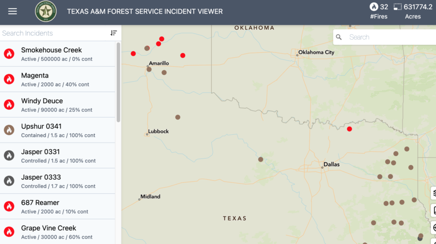
The Smokehouse Creek Fire near Stinnett was first reported Monday evening; USA Today said by Wednesday the fire had grown to about 500,000 acres — twice its estimated size on Tuesday evening — and was still at zero containment, according to the Texas A&M Forest Service.
ABC7 News reported that Texas Governor Greg Abbott announced a disaster declaration yesterday for 60 counties, including all 26 counties in the Panhandle.
Texas fire map
Officials are warning those who evacuated from the town of Fritch ahead of the Smokehouse Creek Fire that destruction there is considerable. “People who live in the Fritch area are probably not going to be prepared for what they’re going to see as they pull into town,” said Deidra Thomas with the Hutchinson County Emergency Management. “There are still homes that are on fire.” The main road into the south side of Fritch is still closed. “Right now, we can’t let you in,” she said. “It is not safe to do that.”
Wildfires northeast of Amarillo in the panhandle, 06:00 EST 02/28/24 28, 2024. The largest, the Smokehouse Creek Fire, is estimated at 500,000 acres.
The governor also directed the Texas Division of Emergency Management (TDEM) to activate emergency response resources for local firefighters battling the multiple fires. “I issued a disaster declaration today to ensure resources are deployed to areas in the Texas Panhandle,” said Abbott.
Strong winds, unseasonably high temperatures, and dry grass are fueling the fires. Hot and dry and windy conditions should continue in the region in the coming days.
FIRE DANGER: Texas A&M Forest Service
Dry conditions and above-normal temperatures resulted in parts of the state facing increased fire risks, according to the Texas A&M Forest Service. Several wildfires across the Panhandle started on Monday, and the Forest Service responded to 13 new requests for assistance on wildfires burning nearly 80,000 acres across the state. CNN reported that the Smokehouse Creek Fire burned 500,000 acres in under 48 hours and forced evacuations in multiple counties. That’s more acres than the combined total of all Texas fires for 2023. Numerous homes on the perimeter of the town of Canadian were burned, Hemphill County Judge Lisa Johnson told The Canadian Record.
The Associated Press reported that fires tore through sparsely populated counties on the High Plains dotted with oil rigs and cattle ranches. By this morning wind speeds had decreased and the humidity has risen. Northwest winds are predicted throughout the morning, shifting to the east around 6 mph late in the afternoon, then to the south late in the day. Forecasters warned there’s also potential for wildfire fire activity in East Texas, the Rolling Plains, and western Cross Timbers, and fire conditions will likely pick up and increase again by the weekend.
There are currently 63 counties with burn bans in place.
~ Thanks and a tip of the hard hat to Jim, Brian, and Patrick.
The San Diego County Sheriff’s Department and the San Bernardino County Sheriff’s Department this week acquired Bell 412EPX helicopters, adding to their airborne resources for emergency response. Three SUBARU Bell 412EPX helicopters were delivered, two to San Bernardino County and one to San Diego.
The Bell 412EPX has an internal weight of 12,200 lbs., external weight of 13,000 lbs., and the ability to carry 5,000 lbs. with its cargo hook.
In San Diego, the Sheriff’s aviation unit, Aerial Support to Regional Enforcement Agencies (ASTREA), completes nearly 6,000 public safety missions each year with its all-Bell fleet of emergency response helicopters, including four Bell 407GXis, three Bell 205s, and its newest addition of a SUBARU Bell 412EPX. ASTREA plans to use its new ship in conjunction with Cal Fire responding to wildfires in the region.
“We are working hard to have crews trained and ready for the upcoming fire season,” said Deputy Gary Kneeshaw, a pilot with San Diego County. “We have found the SUBARU Bell 412 EPX to be a very capable aircraft that is delivering on its promises.”
San Bernardino County is the largest county in the United States — over 20,000 square miles — and its Sheriff’s Department will use its two Bell 412EPX helicopters for law enforcement and emergency response including wildfires and search-and-rescue ops. Over 50 years ago, the Sheriff’s Aviation Unit began operations with two Bell 47Gs; the fleet now includes 17 aircraft.
“Our Air Rescue program is a critical component to providing safety to the residents of San Bernardino County,” said Lieutenant Brian Chambers with the Sheriff’s Department.
The federal government plans to sue PacifiCorp for nearly $1 billion in costs related to the 2020 wildfires in southern Oregon and northern California; the company is trying to negotiate a settlement.
According to an Associated Press report, the pending lawsuits were disclosed in an annual report from the parent company, Berkshire Hathaway Energy, on Monday. The utility company has already agreed to pay hundreds of millions in lawsuits related to the 2020 fires.
Berkshire Hathaway Energy said the Department of Justice is seeking $625 million in suppression and cleanup costs that followed the Archie Creek and Susan Creek fires. Oregon’s Justice Department said it also wants $109 million in damages for those fires, and the Forest Service has asked PacifiCorp for $356 million for suppression and damages over the Slater Fire — which started in California and then burned over the state line into Oregon.
The company estimates that its utilities face at least $8 billion in claims from all the wildfire lawsuits already filed, but damages could be doubled or even tripled in some of those cases.
Other PacifiCorp lawsuits over the Labor Day 2020 fires are detailed HERE and HERE and HERE and HERE and HERE and HERE and HERE.
The PacifiCorp website says the company leads in wildfire mitigation, and its system-wide, six-state plan includes in-house emergency management and meteorology and data science teams — and features the installation of over 450 weather stations, grid hardening, fire-risk modeling software, and an “enhanced” vegetation management program.
“The safety of our employees, customers, and communities remains our top priority,” declares PacifiCorp.
Meanwhile in southeast Idaho, renewable energy developer NorthRenew Energy has sold its 300-MW-plus Arco Wind and Solar project in southeast Idaho to PacifiCorp. This is NorthRenew’s ninth project sale since the company’s inception in 2017.
Renewables Now reported last week that the project in Bingham and Bonneville counties is designed with a storage capacity of more than 300 MW of wind and solar power, but could be expanded by as much as 800 MW of solar energy in the future. The project acquisition extends PacifiCorp’s diverse mix of generating resources across its system spanning the western states of Oregon, Washington, California, Utah, Idaho, and Wyoming.
Famously known as the Red Tails, the first Black military pilots in the U.S. first flew over the skies of Tuskegee, Alabama when U.S. military officials selected the Tuskegee Institute to train pilots, in part because of its commitment to aeronautical training. Tuskegee in the early 1940s had the facilities, the engineering and technical instructors, and a climate at the time for year-round flying for flight training.
The first Civilian Pilot Training Program students completed instruction in May of 1940 — and the Tuskegee Airmen were initiated into the U.S. Armed Forces on February 19, 1942.
The program soon expanded into the center for Black aviators during World War II, and the Tuskegee Airmen quickly overcame their barriers of segregation and prejudice, conclusively proving themselves as a highly respected fighter group of World War II.
The “Tuskegee Airmen” name applies to not just the pilots but also the navigators, bombardiers, mechanics, instructors, crew chiefs, nurses — and even the cooks and other support personnel. Despite the fantastical myths, the outstanding performance and professionalism of the 15,000+ men and women who shared the “Tuskegee Experience” from 1942 to 1946 are documented and commemorated at the Tuskegee Airmen National Historic Site in Alabama.
There’s a list online from Tuskegee University of over 1000 pilot graduates [HERE], preserving a little-known but renowned chapter of fire aviation history in the country.
Below: Members of the 332nd Fighter Group, Ramitelli, Italy, March 1945 photo by Toni Frissell
Image: Members of the 332nd Fighter Group attending a briefing in Ramitelli, Italy, March, 1945 (Frissell, Toni, photographer), LOC
U.S. Forest Service Chief Randy Moore spoke Thursday with loggers and others in forestry about forest fires, logging, and sustainability at the 86th annual Oregon Logging Conference at the Lane County Fairgrounds in Eugene.
The Register-Guard reported that Moore gave the keynote address at the conference before taking questions from attendees, many of whom were critical of the Forest Service’s management of federal forests in Oregon. After his speech, the newspaper questioned the USFS Chief and didn’t get much for answers, which Moore is well known for. Asked about an escaped RxFire last summer east of Eugene, and another over in Grant County that resulted in the arrest and arraignment of FS burn boss Ricky Snodgrass, Moore said he’s confident the agency has the ability to managed prescribed burns.
Referring to the temporary pause in 2022 after the Calf Canyon / Hermits Peak Fire, Moore then said, “If you remember, I called a 90-day pause … And really, it was to do a check on how we were doing prescribed burning, but also to look at what has changed.”
He explained that people are “on different sides of the aisle with climate change,” and that the climate is different today than what it has been. “And because it’s different it’s creating conditions that we have never seen before, particularly as it relates to fire behavior. And so, as we look at the prescribed burning, we do have the ability.”
Regarding the budget, the chief said, “Going in now, of course, you know, we don’t have a budget. The federal government doesn’t have a budget. Our expectation is to have the same level of firefighters we had last year. And so, we’re looking at roughly 11,700 firefighters…. Now, with an uncertainty around budget, could that be potentially compromised? Of course. We also have a housing issue, a mental health issue, with our firefighters. So, all of that plays into whether we’ll be able to recruit and retain firefighters.”
Agriculture Secretary Tom Vilsack back in June 2021 announced that Randy Moore would serve as the 20th Forest Service Chief. “Randy Moore has been a catalyst for change and creativity in carrying out the Forest Service’s mission to sustain the health, diversity and productivity of the nation’s forests,” said Vilsack. A year later in front of the Senate Appropriations Committee, Moore said the 2022 fire staffing was near 90 percent, but he acknowledged that the agency in some areas was staffed at about 50 percent.
Moore was warning a week ago that the agency faces budget cuts that could affect thousands of employees. He sent an all-employee letter noting that funding gaps will affect salaries and information technology, among other things.
He noted a 5 percent cost of living increase but said it will come out of available funds. He had no details on which part of the agency’s budget will be cut for the new fiscal year, but warned that the USDA is developing budget cut guidelines.
Jack Thomas with Jim Lyons in northeast Oregon’s Eagle Cap Wilderness.
Moore was also asked about the planned update to the Northwest Forest Plan, which was developed by Jack Ward Thomas and a small army of experts back in the early 1990s. The comprehensive plan was accompanied by a regional monitoring program and ongoing research, and became a multi-agency effort to conserve biodiversity, especially including old-growth forests, the northern spotted owl and marbled murrelet, and other species associated with older forests on federal lands in western Washington and Oregon and northwest California. It was also designed to protect salmon habitat and to provide forest products for timber-dependent economies. The NWFP was envisioned to be a 100-year plan with the flexibility to adapt to new conditions, threats, and knowledge — of which there have been many.
Asked what changes Oregonians might expect in the forthcoming update to the Northwest Forest Plan, Moore said, “I think that’s to be discovered. I think that we need to sit down and have public meetings. We need to look at what are the expectations that our publics are having for their national forests and then how can we provide that within the context of the laws that guide us.”
In 2024 USFS employees with arduous quals will do the arduous exam. Firefighters with moderate or light duty will have the OF 178 exam if they mark one box in Part A or three in Part B. If you have questions you can email the help desk at SM.FS.mqp_emedical@usda.gov
Arduous Medical Exam (AME) or Self-Certification or (HSQ)
What is the difference between the AMP and the HSQ?
The Arduous Medical Process is for those taking the arduous WCT.
The HSQ is for those employees taking the moderate and light WCTs.
What about the AMP Exam (AME) and Self Certification?
eMedical AMP runs on a 3-year cycle for employees.
Year one is the AME: a thorough health screening questionnaire followed by a physical exam with a medical provider. The exam results are reviewed by a USFS Medical Officer (RMO) before the employee can get medical clearance to take the WCT.
Years 2 and 3 are the self-certification process, which requires a shorter screening questionnaire plus a blood pressure check by an EMT or other qualified individual. The results are reviewed by HSQC’s and, based on the answers, may be routed to the RMO or cleared to the WCT.
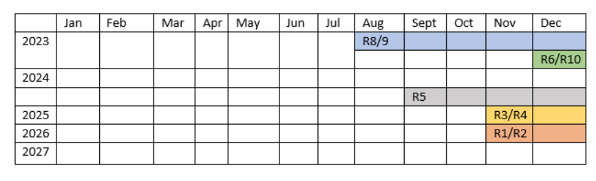
NOTE that this is a gradual rollout over the next few years, not just in 2024 and not all regions are shifting the AMP at the same time. Here is the rollout schedule (subject to change):
Those with arduous qualifications who have not completed the arduous process yet will continue using the current system with the HSQ, alongside all moderate and light quals.
In those areas that are implementing the AMP, Acuity International will assist with scheduling and payment for exams, at the employee’s request. This is a completely optional service.
Firefighters with arduous duty quals must complete a physical exam every three years, and it is required before that year’s work capacity test.
You must fill out a medical history form in eMedical and then you can schedule your exam with your doctor; your supervisor can initiate this for you. If you are approaching three years since your last exam, you should get started at least 45 days before your work capacity test. You can log into eMedical and request a packet.
Annual Self-Certification
A questionnaire and blood pressure check are required each year between your in-person exams. The self-certification form FS-5100-42 is not the same as the HSQ/OF-178. It can also be completed in the eMedical system.
Details on additional exam requirements are posted [HERE].
eMedical Public Site for Temporary, AD, and new employees (available through ConnectHR) — this requires a username and password.
Reflections from 20 years Examining the Social Dynamics of Fire Management
Sarah McCaffrey retired in 2022 after 20 years as a fire social scientist with the U.S. Forest Service; her research focused on understanding the social dynamics of fire management. This included research projects examining the role of risk perception and risk attitudes, social acceptability of prescribed fire, homeowner mitigation decisions, evacuation decision making, risk communication, and agency-community interactions during fires. Since retirement she has been involved with research and practitioner efforts to improve future fire outcomes, including as an adviser to the Gordon and Betty Moore Foundation Wildfire Resilience Initiative and as board member for Fire Adapted Colorado.
McCaffrey received her PhD in 2002 from the University of California at Berkeley, where her dissertation examined homeowner views and actions in relation to defensible space and fuels management at Incline Village, Nevada.
The International Association of Wildland Fire (IAWF), the Pau Costa Foundation (PCF), and the Association for Fire Ecology (AFE) organize the Partner Webinar Series, a monthly series that brings together diverse voices from the global wildland fire community. To suggest a topic or speaker for this series, please contact us.
We got a note today from Anna Dailey about the 1959 Decker Fire, which Bill Gabbert wrote about back in 2013. Three of the six firefighters killed on the Decker were El Cariso Hotshots — Bill Gabbert’s old crew.
Boyd “Mike” Edwards, El Cariso Hotshots
“I just read the report on the Decker Fire of 1959. My 2nd cousin Boyd M. Edwards was killed on that fire. Although Boyd, or Mike as the family called him, was killed about 2½ years before I was born, I grew up knowing how his death devastated our family. Not much was shared with me regarding his death, all I knew was that he died the summer after high school graduation fighting a fire. Now I know many of the details and I was in tears reading it. RIP to everyone who lost their lives that day and the days that followed.”
Anna attached a picture of Boyd, who was buried in Huntington Beach, California. She said she never knew until reading Gabbert’s report this week that her cousin lasted 8 days in the hospital before he succumbed to his injuries.
(NOTE in Gabbert’s 2013 news post that there used to be a report about the Decker Fire on wildfirelessons.net and it’s no longer there. The 1959 report is HERE.)
Bill Gabbert wrote in 2016:
“The official report did a pretty good job of explaining the important facts of August 8, 1959. But more than half a century later, a former firefighter who served on the El Cariso Hotshots from 1963 through 1966 conducted extensive research on what happened that day in 1959 and assembled many details that were not included in the U.S. Forest Service report. Julian Lee, Professor of Biology, Emeritus at the University of Miami (now living in New Mexico), made available to us his 27-page description of the Decker Fire. It is very well written and comprehensive, laying out the details of what occurred during and after the fire, as well as providing some analysis.”
The South Carolina National Guard is providing assistance to Colombia, its State Partnership Program partner, as it faces dozens of wildfires. With as many as 30 active fires in and around Bogota in late January, the SC National Guard has loaned Colombia multiple helicopter buckets, according to a report by Vertical Magazine.
“We are sorry our friends and state partners are experiencing significant fires this year impacting cities like Bogota,” said Maj. Gen. Van McCarty, adjutant general for the state. “The South Carolina National Guard stands committed to assist Colombia with helicopter buckets, which are an invaluable fire-retardant tool.”
The buckets on loan to the Republic of Colombia carry 700 gallons. The partnership between the South Carolina National Guard and Colombia began in 2012. South Carolina ANG Lt. Col. Daniel Linkroum directs the state partnership program with Colombia.
“It was satisfying to get a call to support an immediate need and be able to respond with resources in short order,” he said. “It reaffirms the South Carolina National Guard’s commitment to our partner nation.”
This effort has been years in the making, supported and sourced by the Civil Affairs and Humanitarian Assistance Directorate at U.S. Southern Command.
The Department of Defense State Partnership Program is a cooperative military-to-military exchange administered by the National Guard Bureau. It enables cooperation between U.S. National Guard units and foreign allies. The national program began in 1993 and has grown to include 100 different countries.




 Agriculture Secretary Tom Vilsack back in June 2021 announced that Randy Moore would serve as the 20th Forest Service Chief. “Randy Moore has been a catalyst for change and creativity in carrying out the Forest Service’s mission to sustain the health, diversity and productivity of the nation’s forests,” said Vilsack.