
Information from the Air Tactical Group Supervisor about the 2020 accident
Continue readingReport finds C-130 air tanker that crashed in Australia likely stalled
Three Americans were killed in the 2020 New South Wales accident
Continue readingConstruction costs for fire-resistant home in California
Mitigating destruction in the home ignition zone
Continue readingEvacuations in effect for the Rum Creek Fire in southwest Oregon
14 miles northwest of Grants Pass, Oregon
Continue readingUpdated status on two unsuppressed fires in Yosemite National Park
 Red Fire 3-D map 8:52 p.m. Aug. 27, 2022.
Two wildfires in Yosemite National Park are being managed without the intent to stop the spread. They are being allowed to replicate natural processes, restoring fire to the landscape.
It is a little too far out to predict with much certainty, but possibly by the first half of next week around September 4 or 5, temperatures much higher than average for the date could impact large sections of the Western United States. If it is accompanied by low humidity and strong winds there could be a significant increase in the spread of existing wildfires. We won’t get too excited about it now, but the situation bears watching as the forecasts become more certain.
Perhaps with that medium-range forecast in mind, or it could be unrelated, fire managers at Yosemite are taking steps to modify the spread of two fires. Both of them have large swaths of granite out in front, but the rock does not present a 100 percent impenetrable barrier. However under less than extreme conditions the granite would at least greatly slow the spread of the fires.
Red Fire
The Red Fire is in the southern part of Yosemite near Grey Peak and was mapped at 1,833 acres Saturday evening. The spread has been minimal in recent days as it chews through pockets of dead and and down vegetation. The plan is to use crews and hoselays to keep the fire south and east of the trail system and hold the fire from moving further into the Illilouette basin, which would result in increased smoke impacts to Yosemite Valley.
Rogers Fire
 Rogers Fire 3-D map 10:09 a.m. Aug. 27, 2022.
The Rogers Fire, 10 miles east of Hetch-Hetchy Reservoir had burned 1,370 acres when it was mapped the morning of August 27. Fire managers intend to use helicopters to drop water in order to slow spread to the northeast. This is intended to enable hand crews to construct fire line between granite slabs. The next step is not specified, but depending on the intensity of the fire, which has been low, the line might stop the fire, or provide an anchor from which to start a backburn or backfire.
 Rogers Fire, Yosemite NP, posted August 27, 2022. Inciweb.
Four Corners Fire burns more than 10,000 acres near Lake Cascade in Idaho
24 air miles south of McCall
Continue readingCAL FIRE attaches video camera to air tanker
Video of Tanker 89 dropping on the Still Fire
Continue readingCalifornia OES and military partner to create an engine strike team
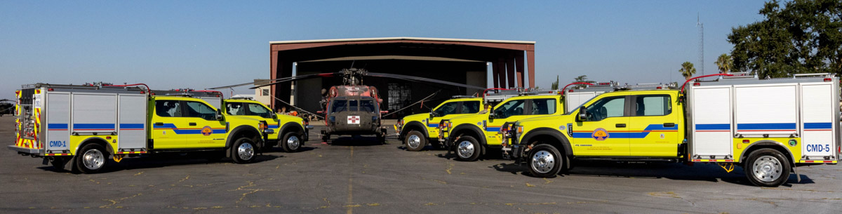 Cal OES and California Military Department’s Type 6 engines. CAL OES photo.
This week the California Governor’s Office of Emergency Services (Cal OES) and the California Military Department announced the creation of the first all-hazards fire engine strike team operated by a state military department.
Cal OES is deploying a Type 6 strike team of wildland-style fire engines, named Team Blaze, to the State Military Department to enhance California’s Fire and Rescue Mutual Aid fleet.
These four-person engines complement the Military Department’s existing Task Force Rattlesnake hand crew program consisting of Soldiers and Airmen. Since the start of operations in 2019, Task Force Rattlesnake has cut, cleared and treated at-risk wildfire project areas in central and northern of California.
The State’s Military Department maintains a firefighting program at their military bases, with trained personnel providing firefighting prevention, mitigation and protection services to California and military bases and camps.
“We are proud to collaborate with Cal OES to ensure there’s another fleet of fire engines and expert staff at the ready,” said California Military Department Major General Matthew P. Beevers. “This Strike Team builds upon the state’s response efforts during times of need.”
 Cal OES and California Military Department Type 6 engine. CAL OES photo.
These engines add to the existing California Fire and Rescue Mutual Aid System fleet of more than 270 engines across 60 local partners statewide that can respond to incidents of all types.
Cal OES facilitates the California Fire and Rescue Mutual Aid System, which moves local government resources across the state in support of all-risk emergency response on behalf of local, state, and federal government fire organizations. Cal OES assigns local government fire agencies with fire apparatus to maintain surge capacity during day-to-day duties and major events/emergencies.
Fire Rescue New South Wales commits to a drone program
 Fire Rescue New South Wales drone.
Fire and Rescue New South Wales (FRNSW) crews across the State are being trained to use state-of-the-art drone technology to assist in firefighting operations and other emergencies.
“These drones are being deployed to 25 regional areas, giving FRNSW crews an eye in the sky to help them better fight fires and keep our communities safe,” said Minister for Emergency Services and Resilience and Minister for Flood Recovery Steph Cooke. “The drones are connected to FRNSW’s wireless and satellite communication networks, allowing images to be viewed and analysed in real time at the scene of an emergency which helps firefighters make quicker decisions and act faster.”
The investment is part of the NSW government’s response to its Bushfire Inquiry recommendations, with $5.2 million earmarked in the state budget to expand the drone program with new aviation staff, training and equipment.
The aircraft are equipped with thermal imaging cameras and laser technology that can detect variable heat temperatures, identify people or animals under threat in a fire zone, and measure the size of an area impacted by fire.
 Fire Rescue New South Wales drone.
FRNSW Bushfire and Aviation Unit Commander Scott Donohoe said the drones can be activated at an emergency scene within minutes.
“The drones are stored in our vehicles and ready for immediate use, providing FRNSW commanders with aerial images that can help determine the safest and most effective places to position fire trucks and crews,” Superintendent Donohoe said.
“We are planning to have around 200 firefighters trained to pilot the drones. The available training over several tiers includes sessions on night flying, situational awareness, live streaming, rapid mapping, aerial incendiary use, and 3D panoramic skills.”
The drones can be used to assess bush fire risk, assist in hazard reduction operations, and find people missing in dense bushland.
The drones have already been deployed to the Northern Rivers region to assess flood-damaged infrastructure, identify hazardous materials, and find leftover debris.
Firefighters battle the East Fire northeast of Glendora, California
East of San Gabriel Reservoir
Continue reading