Taking inspiration from the Iron Dome air defense system that intercepts, targets and destroys incoming rockets to Israel, the newly developed FireDome aims to protect communities from wildfire attack by detecting, targeting and suppressing spot fires before they grow big.
FireDome recently demonstrated its system that features a large AI powered mechanical launcher that rapidly rotates, swivels and adjusts to release retardant or water capsules to suppress fire or create a firebreak.
The launcher has a range of 1000 ft (300m) but FireDome is working on extending that range. The launcher can hold 3000 capsules, each with a capacity of 10 gallons (37 litres), and can reload and fire every 5 seconds.
The AI can detect the intrusion of people, animals, cars or aircraft, and can actively monitor a moving fire front. The company says that tests under more challenging conditions are ongoing, including under varied wind conditions which have the potential to blow any capsule off course.
So, how much does this cost to set it up in your community? The company told Wildfire Today: “Low six figures per year for an end to end service we provide that includes the system and additional fire mitigation tools.”
Advisor to FireDome and former U.S. Fire Administrator, Dr. Lori Moore-Merrell, is quoted on the company website. “FireDome exemplifies the type of breakthrough innovation needed to alter our relationship with wildfire risk,” she said.
“The integration of automated systems with precision suppression technology creates an opportunity for technology to be considered as a variable in risk-based insurance models and in community resilience strategic plans.”
FireDome plans to begin US installations in 2026, partnering with property owners, vineyards, HOAs, resorts, utilities, insurers and the fire service in wildfire-prone regions. Beyond that it is looking to Canada, Europe and Australia as potential markets.
Australia’s fire preparedness just got smarter, more colourful and easier to access.
A new satellite-derived product from Geoscience Australia helps monitor fuel moisture (vegetation dryness) across Australia in near real time. The tool uses Earth observation to provide a clear visual assessment of vegetation flammability.
Developed in partnership with The Australian National University’s Bushfire Research Centre of Excellence, the Digital Earth Australia Fuel Moisture Content assesses fire risk, by estimating the percentage of water mass relative to dry mass in living vegetation based on its spectral signature.
Vegetation moisture changes in the south-west of Western Australia between August 2024 (left) and November 2024 (right). Digital Earth Australia Fuel Moisture Content.
Australia’s hot, dry climate and expansive bushland make understanding vegetation dryness critical for managing bushfire risk.
The DEA Fuel Moisture Content product enables fire and land managers to monitor and map the dryness of vegetation across different landscapes and compare over different time periods to understand changes and trends over time.
The data is delivered as imagery with a 20 by 20 m pixel size and is freely available via DEA Maps and DEA Knowledge Hub.
Updated every few days, at 20-metre resolution, it shows where the landscape is ready to burn before fires start.
The tool was launched with the claim that this is the first time fire agencies, land managers and Indigenous fire practitioners can see precisely where the landscape is ready at this level of detail for the whole continent.
The director of the ANU Bushfire Research Centre of Excellence Professor Marta Yebra began the early work on this tool for her PhD in Spain and built it up into the Digital Earth Australia product of today.
“It’s a glimpse into the future of bushfire management, where satellites and other technologies act like a nervous system for the continent, constantly sensing and responding to changes in the landscape long before smoke fills the sky.” explains Prof Marta Yebra.
Aerial wildfire response has taken a leap forward with the showcasing of new drone technology that aims to hit fires early and fast.
Fresh from its recent launch seeded by $60 million in capital raising, Seneca demonstrated its wildfire suppression drones at the Red Sky Summit in San Francisco this week, with plans to expand its reach beyond the US if successful.
Seneca is building an autonomous fire suppression system that includes autonomous suppression drones that carry 100 lbs, shoot with 100 PSI, and use AI to navigate and knock down fires, with the aim of cutting response times to under 10 minutes.
Seneca wildfire suppression drones
The aerial systems can be launched remotely, needing only an approximate fire location, with the intention striking before a small fire-start becomes a large wildfire. It also has the potential to support prescribed burns and fuel reduction efforts.
The California-based company’s mission is stated variously on its website “to protect…” or “to eliminate” the wildfire threat across 500 million acres in the US and “allied nations” by 2035.
Wildfire Today sought to clarify the concept of an “allied nation” and was informed by Seneca that it sought to serve nations and communities that shared common values. “We expect the western US to host our first deployment sites, and we are grateful to have active dialogue with partners in Canada, Chile and Australia. We do expect to go to international markets in the coming years.”
Seneca wildfire suppression drones
Stuart Landesberg, founder and CEO of Seneca, believes that technology is central to that mission. “Our hope is to empower firefighters in situations that were previously impossible, unsafe, or inefficient. The American way of life has always been about pioneering. Technology is how we will protect communities, preserve our environment, and create a more resilient civilization.”
But the technology focus is not without the human touch, according to Dr. Lori Moore-Merrell, the former US Fire Administrator, and now one of many advisors working with Seneca.
“These AI-powered drones don’t replace our brave men and women on the front lines; they amplify their capabilities while keeping them out of harm’s way. When a drone can deliver rapid water or retardant deployment without risking human life, we’re talking about a paradigm shift that will save both firefighter and civilian lives,” according to a Moore-Merrell statement on the company website.
Senaca’s mission is backed with $60 million led by Caffeinated Capital and Convective Capital with participation from First Round Capital, Transition DCVC, Offline Ventures, and others.
The company says it will use this funding to improve capabilities, harden the overall system, increase production, and roll out the first systems in the field during the 2026 US fire season.
“We have flown test, demonstration, and fuel reduction missions with dozens of fire agencies across CA and in four states. We have never operated internationally but expect to go to international markets in the coming years,” the company told Wildfire Today.
The Earth Fire Alliance has hired NASA’s Wildland Fire Program Manager Dr Michael Falkowski to be its first Lead Scientist.
Earth Fire Alliance is a global nonprofit coalition intent on delivering transformative data and insights from all wildfires around the world.
Dr Falkowski was NASA’s Program Manager for the Wildland Fire Program and led the FireSense project, overseeing an annual budget of around $20 million. In that role, he set strategic priorities for NASA’s wildland fire portfolio, led multidisciplinary teams, and spearheaded national and interagency efforts to advance fire science, data, and technology innovation.
As the alliance’s first Lead Scientist, Dr Falkowski will guide the ambitious research to operations strategy to address wildfire challenges on a global scale.
“I’m honored to join Earth Fire Alliance and contribute to its mission of transforming how the world understands and responds to wildfire,” said Dr Falkowski in a statement from the alliance.
“This is a unique opportunity to unite international science, space-based technology, and real-world operations to build wildfire resilience at the scale this accelerating global challenge demands.”
Dr Michael Falkowski leaves NASA to lead the Earth, Fire Alliance.
At NASA, Dr. Falkowski facilitated the development of wildland fire science and technology to drive actionable outcomes for fire management and resilience.
Before his time at NASA, Dr Falkowski worked in remote sensing and ecosystem science as a professor at Colorado State University, University of Minnesota, and Michigan Technological University. He also served as a wildland firefighter and state and tribal natural resource management specialist,
EFA Executive Director Brian Collins, in the alliance statement, said Dr Falkowski had a blend of scientific rigor and operational experience. “He brings a deep understanding of how to translate research into real-world impact—an essential quality as we scale the FireSat program, expand global partnerships, and deploy new programs.”
Through its FireSat program – a purpose-built satellite constellation designed to detect and monitor every wildfire on Earth in near real time – it aims to deliver unprecedented insights into wildfire behavior and impacts.
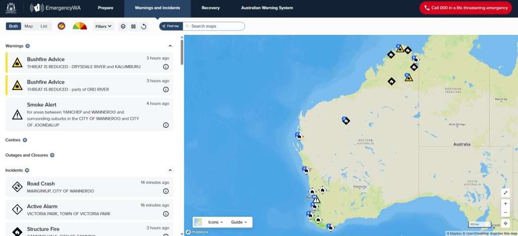
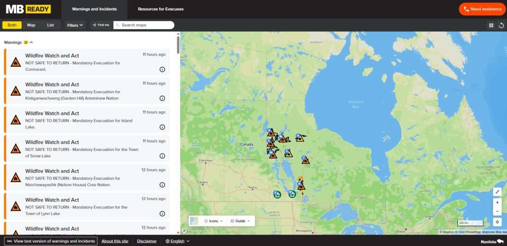
The public emergency warning system developed in Western Australia has been adapted for use by the Manitoba Emergency Management Organisation as MB Ready across the province of Manitoba, Canada.
Multiple states of emergency have been declared across Canada in recent months as hundreds of wildfires burnt out of control, making it the second worst season on record, so soon after the historic 2023 season.
WA firefighters have been assisting with response efforts across Canada this season and in seasons past, but the exchange of technology coupled with strategic and research insights is new.
The Emergency WA app and website enables users to receive rapid notifications for warnings, incidents and other alerts in custom watch zones. It provides critical information to people impacted by emergencies, helping them make life-saving decisions.
The Department of Fire and Emergency Services (DFES) is the agency delivering emergency information for bushfires, floods and cyclones in the vast state of Western Australia, the country’s largest state.
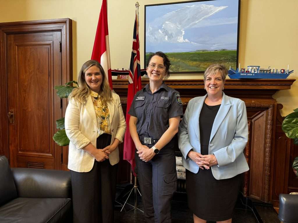
DFES Public Information manager Anni Fordham, a Churchill Fellow, recently travelled to Manitoba to help implement the new warning technology for MBReady, which aims to become the trusted source of information for Manitoba communities.
Emergency WA websiteMBReady 2025
Facing a very challenging wildfire season, Manitoba Emergency Management Organization sought help establishing public information capabilities to help protect communities. After expressing interest in the Emergency WA app, the technical deployment of the platform in Manitoba was completed through Genvis, with the broader contextual support provided by DFES.
In Canada Fordham shared her insights from her Churchill Fellowship, which looked at international best practice and research to improve providing vital information to people in emergencies.
“Technology is critical when it comes to warning systems, but without the right strategies and workflows in place, the system can’t do its job effectively long term,” Fordham said. “So, I spoke with the team about things like when and why we issue warnings, how we source and verify warning information, and how warning templates are developed for different hazards. I also discussed the broader strategic thinking and decades of experience behind our vision for Emergency WA, the community research that informed key design features and the lessons learnt during project implementation.”
Many wildfire regions around the world have emergency apps, and many share similar aims, but each needs to be tailored for its own context, as Fordham explains. “It is crucial for emergency management agencies to learn from each other and share information as the challenges we face are increasingly shared. However, each jurisdiction must prioritise the needs of the communities they serve.”
“While Emergency WA shares some features with other jurisdictional models, it also has national-first features such as the ability to listen live to your local emergency radio broadcasts from within the app, and a button to call Triple Zero from anywhere in the app. Emergency WA was designed with the needs of Western Australian communities in mind – and if those ideas are useful in other parts of the world, we are happy to share them.”
(L-R) Assistant Deputy Minister Christine Stevens of the Manitoba Emergency Management Organization, DFES Manager Public Information Anni Fordham, Manitoba Minister Transport and Infrastructure Lisa Naylor
It comes as several dozen WA emergency services personnel have returned home from battling blazes in Canada while others still remain, as part of the 1400-strong international firefighting force deployed to Canada this season, including from many other Australian states.
The Emergency WA website is the State’s official source for emergency information with more than 36 million page views in the past 12 months and more than 135 million views since its launch in 2016.
The current app version of Emergency WA was launched in December 2024.
The United States’ wildland firefighting force was called the “very best 1990s firefighters” during a congressional hearing on Thursday morning.
San Bernardino County Fire Protection District Chief Dan Munsey, speaking at a hearing held at the House Committee on Natural Resources, said it’s a misnomer to say the US has the most “technologically advanced” firefighting force, since firefighters on the ground are using paper maps and radios from decades ago, compared with the modern technology available to the general public today. Munsey attributed the failure to use modern technology to federal barriers.
“We are slow to innovate, we are burdened by the regulatory process, we are hampered by lengthy bureaucratic procurement processes, and we lack access to fundamental tools,” Munsey said. “We don’t have a technology problem in the United States to combat wildfire; we have a technology adoption problem.”
Lawmakers invited wildfire technology experts to Capitol Hill to start fixing the problem Munsey spoke on. Thursday’s hearing focused on advancing innovative technology for forest management and wildfire prevention. Although some portions were overshadowed by partisan back-and-forths over whose fault the current wildland fire crisis is, lawmakers shared a common goal of adopting more technological advancements to meet the crisis and prevent future tragedies.
The wildfire technology sector continues to grow, including the launch of the Association of Firetech Innovation, which claims to be the first trade association dedicated to supporting technology focused on wildfire prevention, mitigation, and response. The association plans to act as a “central force for policy engagement, investment, and industry collaboration,” and was meeting with congressional leaders as the hearing went on.
One of the association’s founding member CEOs, Allison Wolff with Vibrant Planet, was also a speaker at the hearing and released research showing how a federal investment of $9 million in wildfire risk mitigation treatments would have slowed January’s Eaton Fire enough to mitigate much of the $40 billion in damages the community of Altadena experienced from the fire.
Data analyzed by Vibrant Planet found 300 communities in eight states have a 98% to 100% wildfire risk, similar to Altadena. Wolff also estimated that investing between $40 billion to $73 billion in risk mitigation in communities similar to Altadena, the nation can avoid up to $435 billion in insured losses.
“The problem is that today, without modern tools like ours, it can take three, five, to even 10 years to get to an implementation plan,” Wolff said. “Often, the data is low-quality, and collaborators are often planning on paper. Plans are often obsolete by the time they hit print because the landscape has already burned.”
Many Democratic lawmakers pointed out that the Trump administration’s recent budget cuts to research and development at the United States Forest Service and the Department of the Interior would further slow getting new technologies into firefighters’ hands. Karen Howard, director of science and technology assessment at the US Government Accountability Office, agreed, saying having new tools does nothing if systems aren’t in place to study and use them.
“You could have a beautiful tool that tells you where hazardous fuel reduction will be most effective, but if the agencies…don’t have the resources to conduct that hazardous fuels reduction, the model doesn’t do us a lot of good,” Howard said.
An audience of NASA, FEMA, and wildland firefighting officials recently witnessed the wildfire suppression capabilities of a reportedly “autonomous” Black Hawk helicopter.
Sikorsky, a Lockheed Martin company, partnered with autonomous aerial wildfire containment developer Rain to demonstrate the takeoff, wildfire identification, and water-drop accuracy capabilities of the helicopter.
Lockheed Martin originally announced the helicopter’s development in October, claiming the aircraft could be commanded solely on a tablet from 300 miles away.
“The MATRIX system is unique because it’s not a simple flight director following a planned route. Instead, the system acts fully independently, reacting to the dynamic combat environment to avoid threats, optimize routing, and execute emergency procedures if necessary,” the company said in an Oct. 17 release.
Credit: Lockheed Martin
The recent 30-minute flight demonstration allowed officials to use the command tablet to take off, find the fire, and drop water from a Bambi Bucket 60 feet beneath the aircraft, the company said. The water drops reportedly extinguished 12-inch diameter propane-fueled fire rings to demonstrate the precision of the aircraft’s targeting capability.
“This technology that we used to think of as being on the horizon is here now, no longer just a figment of our imagination,” said Genevieve Biggs, director of the Gordon and Betty Moore Foundation’s Wildfire Resilience Initiative and Special Projects program.
Lockheed Martin isn’t the only organization developing the once-on-the-horizon tech.
Sustainable Aviation Foundation President Brien Seeley recently published a paper on the feasibility and technical details of autonomous aerial fire-fighting (AAF) systems, including eTankers, building small AAF airparks, and autonomous payload carts for loading.
Milrem Robotics partnered with foam extinguishing technology specialist InnoVfoam to develop a line of Multiscope Unmanned Ground Vehicles (UGVs) for firefighter use, including hose use, post-fire extinguishing, and critical supply transport.
The Los Angeles City Fire Department has used a human-controlled water hose tank robot called Robotics Systems 3 (RS3) during fires in buildings with collapsing rooms since at least 2021, the department told Scientific American.
Some scientists, however, are skeptical of just how useful autonomous technology would be to the wildland firefighting force at large. Neil Sahota, an inventor who advises the United Nations on artificial intelligence issues, told Scientific American doubts communities would be willing to pay more than six figures for robots designed for very specific needs, especially for those that still struggle with mobility.
“The economies of scale aren’t quite the same as [for] mass manufacturing,” he said. “We don’t have enough firefighters as it is … With climate change, we’re already at the breaking point.”
For over half a century, the first line of wildfire defense consisted of humans perched on towers hundreds of feet in the air.
Fire lookout towers played an essential role in detecting wildfires since even before the USFS was founded in 1905. The Great Fire of 1910, also known as the Big Blowup, enshrined the towers as cornerstones of the country’s new, now discredited, full fire suppression regime. The lookouts were largely decommissioned between the 1960s and the 1990s after technological advancements in radio communication, aircraft, and even satellites gained favor over the human eye.
The tech advancements, however, lacked two things fire lookouts excelled at: spotting fires early and when they’re small. Even the most advanced modern satellites can detect wildfires only after they burn around three acres. Acreage burned is also updated only a few times daily with low-resolution images.
“Google Research has been developing FireSat, a purpose-built satellite constellation to provide highly detailed insights, data for ecological intervention, and novel ground truth for the scientists and machine learning experts studying fire propagation and risk,” the company said.
The program, called “FireSat,” is a collaboration between Google, the Earth Fire Alliance, and Muon Space. The program is slated to launch around 52 satellites, starting in early 2025 and continuing through 2026, with the goal of providing global high-resolution images updated every 20 minutes to enable early detection of wildfires roughly the size of a classroom.
The satellites reportedly have an expected lifespan of five to seven years, so researchers predict they’ll have to launch 10 satellites annually to keep the program going once it’s up and running.
“Using AI, FireSat will rapidly compare any 5×5 meter spot on earth with previous imagery, while also combining factors like nearby infrastructure and local weather, to determine if there’s a fire,” Google said. “In addition to supporting emergency response efforts, FireSat’s data will be used to create a global historical record of fire spread, helping Google and scientists to better model and understand wildfire behavior and spread.”
Researchers also committed to offer the data as open source and for free to fire agencies and climate researchers around the world.
Researchers, however, affirmed the healthy aspects fire has on some landscapes. They also stressed this new technology wasn’t made with full suppression in mind, but rather as a means to give fire crews and managers the most up-to-date data in order to make the best decisions for managing fire.
“We really want to focus on reducing the size, frequency, and damage of hot and fast fires, and encouraging, as much as we can, slow and cool fires because we need a lot of slow, cool fire in order for ecosystems to improve,” said former Cal State Fire Marshal and Moore Foundation Senior Advisor Kate Dargan. “FireSat, because it will tell us not just where fires are, but also how hot they’re burning…we can develop new strategies for fire management that isn’t just ‘put it out’.”
Credit: Google Research
It will take multiple years for all the program’s satellites to launch, but it will take longer for the system to be fully operational. The first phase of FireSat will strictly be gathering data and sifting through it so fire managers can actually use it without worrying about false positives.
“In the satellite image of the Earth a lot of things can be mistaken for a fire,” said Earth Fire Alliance Chairman and Google Research Climate & Energy Lead Researcher Chris Van Arsdale. “A glint, a hot roof, smoke from another fire covering something that’s warm in the background. There are a lot more of these than real fires, and so detecting fires becomes a game of looking for needles in a world of haystacks.”
Once the false-positive problem is solved, fire managers and scientists will be able to use the data as a visual history of all fires globally. Wildfires will reportedly be tracked step-by-step from when they start to when they are extinguished, which will help researchers better understand fire behavior on the global scale.
Many departments, counties, states and even international countries, especially in the Global South, often face hurdles to this kind of technology due to financial constraints or lack of technological infrastructure. Google researchers said they’re working with partners throughout the globe to identify which aspects of the data they most need and how to best get it to them.
“For example, in Brazil and Indonesia, those are largely regional partnerships where either a government organization or a conservation organization serves our distributor to make sure the data is actually hitting the ground and being used by the agencies themselves,” Earth Fire Alliance Executive Director Brian Collins said.
Agencies interested in joining the program’s Early Adopter Program can reach out to Earth Fire Alliance Community Organizer Ann Kapusta at ann@earthfirealliance.org or get updates by signing up at the Earth Fire Alliance website.
Sikorsky’s “Optionally Piloted” Black Hawk helicopter equipped with MATRIX and Rain autonomy systems during fire localization and targeting demos at Sikorsky HQ in Stratford, Connecticut.
Photo couresy of RAIN.aero
Rain.aero, a developer of aerial “wildfire containment technology” along with Sikorsky, have been for some time now researching wildfire suppression autonomous response possibilities. The companies completed test flights over a year ago with an “autonomous helicopter” that can carry and drop water onto wildfires in early stages of initial attack.
Rain — and Sikorsky — demonstrate early detection and fast response to wildfires, with an autonomous Black Hawk helicopter. The two companies have completed flight tests demonstrating how a helicopter flying with Sikorsky MATRIX and Rain’s “Wildfire Mission Autonomy System” could be quickly launched for initial attack.
The flight demonstration was at Sikorsky headquarters in Stratford, Connecticut, with the “Optionally Piloted Black Hawk helicopter” flying in autonomous mode with Sikorsky safety pilots on board.
Maxwell Brodie
“In 2023, in collaboration with Sikorsky, we set out to prove that we could receive an alert about a possible wildfire, send commands to launch and fly an autonomous helicopter capable of moving a large amount of suppressant to a fire’s location, and then command the helicopter to accurately drop water onto the fire,” said Rain CEO Maxwell Brodie. “We are very pleased with the results that successfully demonstrate autonomous early detection and rapid response.”
What do you think about these developments? Are you a helicopter pilot, or helitack, or hotshot or other ground crew member, or lead plane pilot or ATGS ?
I don’t know enough about the air show environment to have a first-hand opinion on pilot-free helicopters in any role on any fire. I first off can’t imagine where the pilot-free RC helicopters might even be sited (on public land? Large ranches checkerboarded with BLM 40s? Western states private timber holdings? federal or state agency land? Wilderness areas?) and how vandalism possibilities likelihoods (let alone pilot-skill vandals or cyberhacked outside operators) for pre-positioned rotorcraft of any kind (let alone a Sikorsky) might be mitigated or prevented or acted upon …
Fire detection sensors are being set up around Maui and other Hawaiian islands to allow local resources to respond faster when wildfires break out, said Governor Josh Green today.
CNN reports that Maui Mayor Richard Bissen added, “The introduction of an early detection system will give our first responders a critical advantage in protecting our community. With this new technology, detecting fires at the very early phases will save lives.”
According to MauiNow, the remote sensors are en route to Kīhei and Lahaina, and they will use a combination of thermal imaging, gas detection, and Artificial Intelligence (AI) algorithms; the wildfire sensors detect concentrations or spikes in particulates or carbon monoxide to identify wildfire ignition — in real time. The sensors transmit data by email or text notifications to pre-set contacts, and the remote units are small enough for installation on utility poles or traffic lights. They can also work in all weather conditions, according to the U.S. Department of Homeland Security.
“What’s important is we get to the scene as fast as we can, so that we can catch fire in incipient phases,” said Maui Fire Chief Brad Ventura. “Today we share one more tool that’s going to help expedite our responses to our communities.”
About 80 fire sensors are being set up around the islands; the first 20 on Maui are planned for deployment by the first week of April.
These sensors detect heat and also can track anomalies such as airborne smoke particles and gases produced by fires — and can distinguish those from other substances common in the air around Hawai’i — including volcanic ash and ocean salt.
~ Thanks and a tip of the hardhat to Rick for this.