Residents near Perth on the southwestern coast of Australia are being warned to evacuate or risk losing their lives, with an emergency bushfire warning in place.
Perth on the southwest coast of Australia
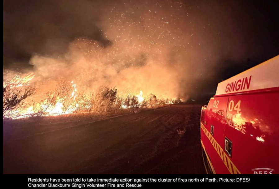
The bushfire alert was in effect on Monday morning, and the Department of Fire and Emergency Services (DFES) warned that homes and lives were at risk. Residents in other towns including Bindoon, Breera, Gingin, Lennard Brooke, Mooliabeenee, and Moondah were warned that they were “in danger and need to act immediately to survive,” with homes on Wowra Drive and Lennard Road under direct threat by fire.
Photo by Chandler Blackburn, Gingin Volunteer Fire & Rescue
Residents were told to take immediate action with the cluster of fires north of Perth and were warned to either leave for safety — or take shelter in their homes if it’s not safe to evacuate. Residents not at home were warned to not try to return.
More than 200 firefighters and aviation support staff are fighting the cluster of fires in the Gingin and Chittering shires, and a severe heat warning indicated that temperatures were rising into the mid-forties (40°C = 104°F).
Nikki Wood photo, DFES – Gingin Volunteer Fire & RescueAn emergency bushfire alert has been issued for residents just an hour away from Perth, the Australian reports. Warnings were issued for Bambun, Coonabidgee, Breera, and Lennard Brooke. “There is a possible threat to lives and homes as a fire is approaching in the area and conditions are changing,” the DFES warned.
Bushfire-prone weather conditions are expected for the rest of this week, with a thunderstorm warning adding to the fire danger. The Bureau of Meteorology issued an extreme fire danger warning for the areas of Barrup and Blackwood with hot, dry and windy conditions increasing fire danger. Lightning and wind from thunderstorms in the South West Land Division could also ignite and exacerbate fires, and heatwave warnings were issued for much of Western Australia.
The blaze has burned 10,579 hectares (26,133 acres) in Western Australia
Map shows heat detected by a satellite at the bushfire northeast of Perth, Western Australia as late as 7:06 p.m. local time Feb. 4, 2021.
Western Australia Premier Mark McGowan announced $4,000 emergency funding will be provided for those whose homes have been destroyed by the fire northeast of Perth. In addition, $2,000 will be made available for those whose homes have been damaged.
The Premier said the Shady Hills area has been saved, “a remarkable achievement given the ferocity of the fire,” he said, but the total number of homes destroyed in the bushfire is now assessed at 81.
Fireys could get some relief Saturday with a 90 percent chance of rain, about 10-20mm according to the forecast. The high temperature Saturday will also drop to 21°C.
One more large air tanker was flown across the continent to assist with the blaze that has burned 10,579 hectares (26,133 acres) according to a Friday morning update from Emergency WA. This brought the fleet of large air tankers temporarily in Western Australia up to three — two 737s operated by NSW RFS and Coulson, and one Coulson C-130.
NSW RFS’ 737 dropping on the Perth Hills Bushfire. ABC image.Tracking the large air tankers working Perth Hills Bushfire, reloading at Busselton. Coulson image; two 737s and one C-130.
The blaze has burned over 25,000 acres (10,000 ha)
Updated at 3:13 a.m. AWT, February 4, 2021
Map shows heat detected by a satellite at the bushfire northeast of Perth, Western Australia at 2 a.m. local time Feb. 4, 2021. The lighter-colored icons are the most recent.
A satellite that detected heat on the Perth Hills bushfire in Western Australia at 2 a.m. local time on February 4, showed that most of the growth on Wednesday was on the north side of the fire, southeast of Bullsbrook. (See the map above.)
Emergency WA reported at 1:48 a.m. February 4 that the fire has now burned 10,237 hectares (25,296 acres). The number of reported homes burned has not changed, and is still 71.
The weather forecast for Muchea predicts cooler temperatures for Thursday, 28°C in the afternoon and wind out of the east-southeast at 28km/h with a relative humidity of 22 percent. Friday will be about the same.
Updated at 10:16 a.m. Western Australia time, Feb. 3, 2021
Authorities have updated the number of homes burned in the bushfire northeast of Perth in Western Australia to 71. (scroll down to see a map of the fire)
Officials are advising residents who are advised to evacuate to not worry about the COVID lockdown.
The revised weather forecast for Muchea is now predicting wind gusts up to 70 kph in some areas, which will make the work of the firefighters even more difficult. For Wednesday, sunny in the afternoon. Winds E/SE 15 to 20 km/h tending S/SE in the morning then increasing to 25 to 40 km/h in the middle of the day. Gusts to 70km/h possible about the hills and foothills during the evening. Daytime maximum temperatures in the low to mid 30s. The relative humidity will be 30 percent in the afternoon.
Emergency WA reported the fire has now burned 9,464 hectares (23,886 acres). The cause of the fire, which is being managed by the Department of Fire and Emergency Services, has not been released.
Originally published at 5:17 a.m. Western Australia time, Feb. 3, 2021
Map shows heat detected by a satellite at the bushfire northeast of Perth, Western Australia at 3:10 a.m. local time February 3, 2021.
A bushfire has destroyed 59 homes northeast of Perth, Western Australia. The blaze was about 14 Km north of Midland and approximately 13 Km south of Muchea at 3:10 a.m. Feb. 3 local time (see the map above).
Emergency WA reports that it has burned 9,189 hectares (22,700 acres) since it was reported at 12:02 p.m. February 1, 2021.
An emergency warning is in place for parts of the shires of Mundaring, Chittering and Northam, and the City of Swan, forcing hundreds of residents to evacuate. Suburbs affected include The Vines, Ellenbrook, Gidgegannup, Upper Swan, Baskerville, Aveley, Henley Brook, Bullsbrook, Brigadoon and Wooroloo.
A Watch and Act warning is in place for nearby areas including Hovea, Stoneville, Wundowie, Mount Helena, Jane Brook, Herne Hill, Muchea and Parkerville.
The weather forecast for Wednesday for the Muchea area calls for 35°C in the afternoon and wind out of the south-southwest at 17km/h with a relative humidity of 30 percent. Thursday the wind will be stronger and out of the east-southeast at 24 to 31 km/h with 22 percent relative humidity. These conditions could increase the danger to areas north of the fire.
I have seen many videos shot while driving through fire areas, but none that showed worse visibility caused by smoke as seen in the video below.
Firefighters dodged flames while driving in Western Australia, as fire officials issued an emergency warning following a bushfire that broke out east of Perth.
Since December a large air tanker has been stationed in Western Australia on a three-month deployment at Busselton for the 2020/2021 bushfire season — Tanker 132, a C-130 operated by Coulson. To help with the fire it is being joined by New South Wales Bomber 210, which is a 737, and a lead plane.
Following a request from Western Australia the #NSWRFS is deploying the Marie Bashir (Large Air Tanker) and lead plane to assist firefighters battling blazes near Perth and across the state over the next week. pic.twitter.com/jGKXu04Hyx
The icons on the map represent heat detected at the Red Gully Bushfire by a satellite at 2:10 a.m. AWT January 6, 2021.
A large bushfire has forced some residents in Western Australia to leave their homes. The Red Gully Bushfire has been burning since January 2 between the Gingin and Dandaragan areas about 100 km. north of Perth. The blaze stretches from Regans Ford west toward Lancelin and is burning toward Indian Ocean Drive.
Emergency WA issued the following warning at 7:44 a.m. AWT January 6, 2021:
Bushfire Emergency Warning – in or near OCEAN FARMS ESTATE, SEAVIEW PARK and surrounding areas bounded by Brand Highway to the east, Nammegarra Road to the north, the northern end of Mimegarra Road, Meadows Road, the coast to the west, Sappers Road to the south, Indian Ocean Drive, K.W. Road, Sappers Road, Cowalla Road and east to Brand Highway at the Orange Springs Road intersection across the northern edge of Moore River National Park in parts of REGANS FORD, COWALLA, MOORE RIVER NATIONAL PARK, NILGEN, MIMEGARRA, WEDGE ISLAND, KARAKIN, ORANGE SPRINGS and LANCELIN in the SHIRES OF GINGIN and DANDARAGAN
The fire has burned more than 2,000 ha (4,900 acres) and has been spreading to the west or west-northwest at about three kilometers per hour.
Two of Coulson’s C-130 air tankers that are on contract in Australia are now positioned in Western Australia.
Coulson C-130 air tankers, 131 and 132. (They have different numbers in Australia) Coulson photo.
Their Rx season is usually from early spring to early summer.
Smoke from a prescribed fire in the Warren Region of Western Australia. Screenshot from the Western Australia Parks and Wildlife Service video.
The prescribed burning season in the Warren Region of Western Australia usually winds down this time of the year during the early summer months. Their wildfire season typically extends from October to May.
The official designations of the seasons south of the equator in Australia are laid out like this:
Summer: December – February
Autumn: March – May
Winter: June – August
Spring: September – November
Map: Warren Region of Western Australia. Click to enlarge.
In addition to telling us about the prescribed burning video (below), Dr. Lachlan McCaw, Senior Principal Research Scientist with Western Australia’s Department of Biodiversity, Conservation and Attractions, sent us an overview of of their prescribed burning program in the Warren Region:
The Region is situated in the southwest part of Western Australian and features extensive areas of native vegetation, including designated wilderness areas and the state’s tallest forests. The region is also home to iconic tourism destinations, a rich and diverse agricultural industry, and unique conservation values associated with the highest rainfall area of Western Australia.
Public lands within the region are managed by the Department of Biodiversity, Conservation and Attractions Parks and Wildlife Service and include 0.65 million hectares (1.60 million acres) of national parks and nature reserves, 0.25 million hectares (0.617 million acres) of state forest and timber reserves, and a lesser area of unallocated crown land and unmanaged reserves.
Southwest Western Australia has a Mediterranean type climate with warm dry summers and the fire season typically extends from October to May. Open forests and heathlands become dry enough to burn in early spring whereas tall dense forest types may retain moisture into the early months of the austral summer.
Prescribed fire is an important tool for land management in southwest Western Australia and in the Warren Region the annual burning program undertaken by the Parks and Wildlife Service may vary from 30,000 ha (74,000 a.) to 70,000 ha (172,000 a.). Prescribed burning is undertaken for a number of purposes including:
To mitigate the risk and severity of bushfires and assist in the protection of lives, property and infrastructure by reducing the build up of vegetation fuels;
To maintain biodiversity and habitat diversity;
To reestablish vegetation after timber harvesting and disturbance by mining operations;
To understand the behaviour of fire and its interactions with the environment.
When agencies in the Western United States set up a large Incident Command Post many fire organizations haul in trailers of one type or another, but this video shows how the Parks and Wildlife Service in Western Australia gets it done.
Wondered what goes on behind the scenes at a #bushfire? Watch as our mobile incident control centre is set up to respond to a major #fire. Fully equipped with satellite comms and offices, this centre is where the incident controller leads the fire response. @dfes_wa pic.twitter.com/vpfrLgOrSJ
I imagine the units are quite a bit less expensive to procure than rolling stock, and it looks like they could be set up rather quickly on flat ground. If the units have to be leveled, I suppose you could raise them with the fork lift and slip concrete blocks and/or layers of 2″ x 12″ boards under them.