Update on the international Bull fire


Firefighter monitors for lingering flames on the Bull fire
Firefighter monitors for lingering flames on the Bull fire. Photo: Eastern Arizona IMTeam

Firefighters have made unprecedented progress on the Bull fire, which started in Mexico on Friday April 29, and soon crossed the international border coming to within a few miles of Nogales, Arizona. A news release issued Saturday by the Coronado National Forest said the fire had burned a total of 23,000 acres, with 11,000 of those acres being on the U.S. side of the border. Sunday’s 8:00 a.m. news release from the same source reduced that acreage to an “estimated” 8,700. It did not specify the number of acres burned on each side of the border. (An update on InciWeb Sunday night clarified that a total of 24,000 acres had burned, with 9,711 acres being blackened on the U.S. side of the border.)

Here is more information from the Sunday news release:

General Information:

The Eastern Arizona Type 2 Incident Management Team assumed command of the Bull Fire at 6 p.m. on Saturday. The Incident Command Post is located at Calabases County Park, Santa Cruz County, AZ.   The fire is currently burning on lands administered by the Coronado National Forest within the Nogales Ranger District.

Fire Activity: Extreme fire behavior and long-range spotting during gusty wind conditions have been observed. Currently the fire is backing down slope into the wind and wind-driven fire in some drainages is also occurring. Flame lengths are 5 to 10 feet.

Significant Events: Personnel who worked through the night on Friday, conducted burnout operations halting the fire’s northern movement. Today, firefighters will continue to hold and secure firelines, extinguish hot spots close to the edge of the fireline and respond to new fire starts in the area.

The map of the Bull fire, below, shows heat detected by satellites on May 1, 2011.

Bull Fire map 5-1-2011
Bull Fire map, showing heat detected by satellites on 5-1-2011. MODIS/USFS

Bull fire crosses border from Mexico, approaches Nogales, AZ


Bull Fire map 4-30-2011
The Bull fire crossed the border from Mexico and is burning 5-7 miles west of Nogales, Arizona and Nogales, Mexico. The map shows heat detected by satellites, April 30, 2011. The border is the yellow line. Another fire is shown 15-20 miles south of Nogales. MODIS/Google Earth

The Bull fire that started in Mexico southwest of Nogales, Arizona, has crossed the U.S./Mexico border and according to MODIS fire detection satellite maps is burning 5-7 miles west of Nogales. The fire has been very active over the last 24 hours and spread rapidly from Mexico into the United States.

The weather on Saturday will not slow down the fire, in fact firefighters are going to be challenged by 23 mph winds gusting up to 37 and a relative humidity of 14%. The predicted wind out of the southwest is not the most favorable wind direction for protecting the cities along the border, with the fire burning southwest of the populated areas.

Firefighters from the Coronado National Forest crossed the border on Friday and provided 40 firefighters, 2 helicopters, and one air attack plane to help Mexico firefighters suppress the fire. Now their hands are full dealing with the hundreds or thousands of acres burning on the U.S. side of the border.

Just to keep things interesting, another fire is burning in Mexico about 15-20 miles south of Nogales, and can be seen in the map above.

KGUN reports that Coronado National Forest officials said two firefighters were injured while working on the Bull fire on Friday and were taken to a hospital with non-life threatening injuries.

The National Situation Report, says 2,000 acres have burned and the fire is 0% contained, but it has little other information about the fire:

Bull, Coronado NF. IMT2 (Philbin). Ten miles west of Nogales, AZ. Grass and understory. Extreme fire behavior. Residences threatened


UPDATE at 10:52 a.m., MT, April 30, 2011

The Coronado National Forest just placed some information about the fire on InciWeb:

The Bull Fire is burning approximately five miles west of Nogales, Arizona on the Nogales Ranger District, Coronado National Forest. The fire is approximately 4,500 acres in size, located on both sides of the border with the International Republic of Mexico. Approximately 600 acres are burning in Arizona. 150 personnel are working the incident, assisted by aircraft. The Eastern Arizona Type 2 Incident Management Team has been ordered to assume command of the incident at 1800 hours local time 4/30/2011.

Significant Events: Burnover on 4/29/2011, with two personnel involved. Both individuals have been treated and released.

Planned Actions: Transition to Eastern Arizona Type 2 Team will occur at 6:00pm tonight 4/30/2011. Indirect attack and burnout operations with large amounts of fuel between firefighters and fire due to topography hazards and concerns.

UPDATE at 12:46 p.m., MT, April 30, 2011

The Nogales International is reporting that Heidi Schewel, a spokesperson for the Coronado National Forest, said the fire has burned 10,000 acres with 5,000 of those acres burning in Arizona.

Concerning the two firefighters that were injured in a burnover on Friday, she said one was released from the hospital on Friday. The second firefighter was discharged on Saturday after being treated for first- and second-degree burns.

UPDATE at 3:02 p.m., MT, April 30, 2011

A spokesperson for the Coronado National Forest, Marylee Peterson, told Wildfire Today that the fire has now burned 23,000 acres, with approximately 11,000 of those being on the U.S. side of the border. She said there are three Air Attacks, one lead plane, and two heavy air tankers working on the fire, as well as five engines. A Type 3 Incident Management Team will transition onto the fire at 6 p.m. Saturday evening.

U.S. firefighters and helicopters fight wildfire in Mexico

The Coronado National Forest has provided 40 firefighters, 2 helicopters, and one air attack plane to help Mexico firefighters suppress two fires that are about 3 miles south of the U.S. border west of Nogales, Arizona, in accordance with the International Agreement the U. S. Forest Service has with Mexico. The firefighters are attempting to two fires together, the Bull fire into the Pena fire, which have burned approximately 2,000 acres each.

Bull and Pena fires in Mexico
Map showing heat detected (in red and orange) by satellites from fires in Mexico, southwest of Nogales, AZ, April 29, 2011; time unknown. The black line is the U.S./Mexico border.

Unfortunately, we don’t know the exact time and date of the data represented in the image above. The new “improved” user interface for MODIS Active Fire Maps no longer includes that information. Our guess is that it was acquired sometime after midnight early Friday morning. A couple of days ago we reported to the U.S. Forest Service that this information and the names of cities had disappeared from their maps. Since then the names of cities have been restored, but not the exact times of the data acquisition.

UPDATE at 2:44 MT, April 29

The Southwest Coordination Center sent this out via Twitter 4 minutes ago:

Update: Bull (AZ-CNF). Mexico fire which crossed border. Approx 3,750 ac (300+ on U.S.). Fire is active today. Air tanker, lead ordered.

Here is an updated map, which appears to confirm that the fire is near the border, or has perhaps crossed it into Arizona. The data is from April 29, but as explained above, the time is unknown.

Bull and Pena fires in Mexico and the U.S. 4-29-2011. Time unknown.

UPDATE from SWCC via Twitter at 3:17 MT, April 29

Update: Bull (AZ-CNF). Type 2 IM Team ordered. Eastern Arizona IMT (Philbin, IC) to fill. DTN 4/29, 1800.


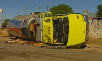
New Mexico water tender rolls over while responding to grass fire

Sierra VFD rollover
KOB.com

A $300,000 water tender from the Sierra Volunteer Fire Department in New Mexico was totaled when it rolled over Thursday while responding to a grass fire. According to state police, the 27-year old operator of the rig, Adam Chrisman, was given a citation for careless driving. He suffered a head injury and was taken to a hospital as a precaution.

Here is a video report on the accident, from KOB.com:

Just in the last nine months, Wildfire Today has reported on five other fire apparatus rollovers that occurred while firefighters were responding to wildfires, here, here, here, and here.

Texas Governor criticizes federal government for not giving the state enough money to fight fires

Texas Governor Rick Perry on Thursday criticized the United States government for not approving quickly enough a request he put in to FEMA for federal funds to assist the firefighting effort in Texas. Perry requested a federal disaster delcaration two weeks ago and said yesterday “You have to ask, ‘Why are you taking care of Alabama and other states?’ I know our letter didn’t get lost in the mail. There is a point in time where you say, ‘Hey, what’s going on here?”

A federal disaster declaration could reimburse Texas and local governments 75 percent of the cost of their firefighting response.

Governor Perry has not been on the best of terms with the federal government. Several times he has flirted with the concept of Texas seceding from the United States. President Obama said last week during an interview with a Dallas TV station, “Governor Perry helped balance his budget with about $6 billion worth of federal help – which he happily took – and then started blaming the members of Congress who had offered that help,” Obama told WFAA, referring to 2009 federal stimulus funds.

Currently firefighters from 35 states, many of them federal firefighters, have traveled to Texas to help Governor Perry and the citizens of Texas with their fires. In addition, two Type 1 Incident Management Teams and one Type 2 Incident Management Team from outside the state, as well as four military MAFFS air tankers, are assisting the state of Texas.

Federal government has given over $39 million in fire grants to Texas

During the 2009 and 2010 award periods, the federal Department of Homeland Security through FEMA awarded $39,747,075 to Texas fire departments and state organizations for firefighting, through the Assistance to Firefighter Grants, Staffing for Adequate Fire and Emergency Response Grants, Fire Prevention and Safety Grants, and Fire Station Construction Grants. That dollar amount does not include complete data for two of the grant programs (FP&S and FSC) which have not yet provided their information for the 2010 grant application period. In 2009 those two grant programs gave a total of $4,339,014 to Texas.

A couple billion dollars in the Texas rainy day fund

At the Texas Emergency Management Conference yesterday, the governor said: “If you hit Houston with a Category 4 or 5 (hurricane), and we’ve only got a couple billion dollars in the rainy day fund, instead of going in and rebuilding and recovering, we’re talking about bankruptcy,” Perry said. “That’s the choice that we have here.”

It’s “raining” fire in Texas, but Governor Perry would rather use tax money generated by the other 49 states, than tap into his rainy day fund. If Texas secedes from the United States, I wonder if the state will then request Foreign Aid.

UPDATE at 11:30 a.m., May 5, 2011:

More information about this can be found here, including the fact that Texas has received 25 FEMA grants for wildfire assistance so far this year.

Station fire forum fans flames of frustration

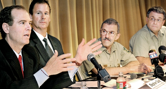
Station Fire Forum
Congressman Adam Schiff, left, speaks to residents during a Station Fire update meeting at the Altadena Public Library Thursday, April 28, 2011. Joining him on the panel, from left to right, were Stephen Gaty, Assistant Director of the Government Accountability Office, Natural Resources and Environment Team, Tom Harbor, Director of Fire and Aviation, U.S. Forest Service and Marty Dumpis, Deputy Forest Supervisor, Angeles National Forest.(SGVN/Staff Photo by Walt Mancini)

Updated, May 18, 2011

The Whittier Daily News has an interesting account of yesterday’s forum hosted by Congressman Adam Schiff about the management of the 2009 Station fire that burned 160,000 acres near Los Angeles.

ALTADENA – Foothill residents left a community forum on the Station Fire with few questions answered and little confidence on Thursday, after Forest Service officials gave scant details as to how properties will be protected in the event of another devastating wildland blaze.

Rep. Adam Schiff, D-Pasadena, moderated Thursday’s forum on the mismanagement of the Station Fire, the largest wildland fire in Los Angeles County history.

Forest Service officials, as well a representative from the Congressional Government Accountability Office, tried to allay fears of a possible repeat of the 250-square-mile blaze that killed two Los Angeles County Firefighters and destroyed dozens of homes.

Homeowners, many of whom  watched their houses burn in the Station Fire, weren’t convinced that much has changed.

“We are not safer,” said Rod Driscoll, whose Vogel Flats home was destroyed in the Station Fire. “We are going to be in the same situation this year in the area to the east that didn’t burn in the Station Fire.”

Forest Service officials were also criticized for not providing straight answers to the residents at the forum.

“I feel like some of these generalizations that you are giving, aren’t answering the questions these people are addressing,” said Sandra Thomas, Altadena Town councilwoman.

Tom Harbour, Forest Service director of aviation and fire management, spoke about the improved communications between agencies and the commitment to protecting property and lives in the event of another fire.

Harbour’s words fell short of comforting the audience.

“I got out of there with my car, my clothes on my back and my cat,” said Duncan Baird, retired battalion chief from the Pasadena Fire Department, who lost his Tujunga Canyon home in the blaze.

The Forest Service launched a feasibility study to examine the use of night-time helicopter water drops. The tactic was prohibited by the Forest Service during the Station Fire despite the proven effectiveness of Los Angeles County Fire helicopters in fighting fires from the air after dark, Harbour told the audience at the Altadena Library on Thursday.

Meanwhile, the Forest Service entered into an agreement with Los Angeles County Fire to conduct nighttime air operations upon request, Harbour said.

“We are in the night flying business right now with the helicopters being supplied by Los Angeles County,” Harbour said.

But limitations in the equipment could curb the volume of night flights.

Harbour told the audience that operating the helicopters on consecutive shifts with separate flight crews could “wear out” the helicopters.

Harbour’s comments set off groans and one man yelled: “In other words nothing has changed.”

“We are going to wear out our aircraft,” said Laura Olhasso, in a rare moment of sarcasm during the meeting. “That’s less than confidence-inspiring.”

Olhasso, a councilwoman in La Canada-Flintridge, harshly criticized federal officials for not releasing information from the investigation into the Station Fire some 20 months after the disaster struck.

“I am dismayed by the pace of the inquiry,” she said.

The GAO agreed to investigate the management of the Station Fire in 2010. After seven months of inquiry, Stephen Gaty, the agency’s assistant director of natural resources, declined to comment on the initial findings from the federal probe and told the audience the report won’t be released until late 2011.

While Harbour promised the residents that the Forest Service would throw all available resources at a fire, he noted that air operations are “expensive.”

Those comments also elicited groans from the crowd, some of whom openly wondered how much a lack of funds played into the grounding of aircraft during the early stages of the Station Fire.

“If those early decisions were made because of money, I ask you not to make that decision again,” said John Grancich, of Millard Canyon.

Written by Brian Charles

=======================

UPDATE May 3, 2011

The Montrose Patch also wrote an article about the forum. Here is an excerpt:

Duncan Baird, a homeowner in the Big Tujunga Canyon area, where several dozen homes were lost, echoed the complaint of many that the Forest Service did not try to protect the area in the 48 hours after the blaze started on Thursday August 27, 2009. The Big Tujunga Canyon residents lost their homes on Saturday.

“There was a period of time all day Thursday and all day Friday when some serious mitigation could have been done with an aerial assault to pre-treat fuels in our canyon,” Baird said. “As it turned out there was absolutely zero work done in the canyon before the fire took our homes and everything we owned. ”

Baird and others questioned whether the Forest Service calculated whether saving their property would be worth the cost of deploying additional fire resources.

Harbour defended the agency’s response as being an”aggressive, assertive initial attack.”

He said cost factors are not considered when trying to put out a fire.

“We are not constrained by cost…we want to get the fire out. There is, hopefully, no question about that,” Harbour said.

UPDATE May 18, 2011:

Found another version of what happened at the forum, this time an article by Paul Pringle of the LA Times.

Thanks Dick and Greg