Station fire forum fans flames of frustration

Station Fire Forum
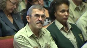
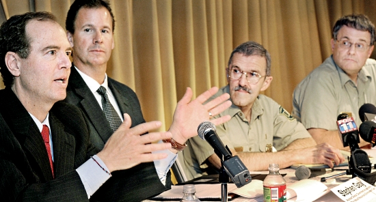
Congressman Adam Schiff, left, speaks to residents during a Station Fire update meeting at the Altadena Public Library Thursday, April 28, 2011. Joining him on the panel, from left to right, were Stephen Gaty, Assistant Director of the Government Accountability Office, Natural Resources and Environment Team, Tom Harbor, Director of Fire and Aviation, U.S. Forest Service and Marty Dumpis, Deputy Forest Supervisor, Angeles National Forest.(SGVN/Staff Photo by Walt Mancini)

Updated, May 18, 2011

The Whittier Daily News has an interesting account of yesterday’s forum hosted by Congressman Adam Schiff about the management of the 2009 Station fire that burned 160,000 acres near Los Angeles.

ALTADENA – Foothill residents left a community forum on the Station Fire with few questions answered and little confidence on Thursday, after Forest Service officials gave scant details as to how properties will be protected in the event of another devastating wildland blaze.

Rep. Adam Schiff, D-Pasadena, moderated Thursday’s forum on the mismanagement of the Station Fire, the largest wildland fire in Los Angeles County history.

Forest Service officials, as well a representative from the Congressional Government Accountability Office, tried to allay fears of a possible repeat of the 250-square-mile blaze that killed two Los Angeles County Firefighters and destroyed dozens of homes.

Homeowners, many of whom  watched their houses burn in the Station Fire, weren’t convinced that much has changed.

“We are not safer,” said Rod Driscoll, whose Vogel Flats home was destroyed in the Station Fire. “We are going to be in the same situation this year in the area to the east that didn’t burn in the Station Fire.”

Forest Service officials were also criticized for not providing straight answers to the residents at the forum.

“I feel like some of these generalizations that you are giving, aren’t answering the questions these people are addressing,” said Sandra Thomas, Altadena Town councilwoman.

Tom Harbour, Forest Service director of aviation and fire management, spoke about the improved communications between agencies and the commitment to protecting property and lives in the event of another fire.

Harbour’s words fell short of comforting the audience.

“I got out of there with my car, my clothes on my back and my cat,” said Duncan Baird, retired battalion chief from the Pasadena Fire Department, who lost his Tujunga Canyon home in the blaze.

The Forest Service launched a feasibility study to examine the use of night-time helicopter water drops. The tactic was prohibited by the Forest Service during the Station Fire despite the proven effectiveness of Los Angeles County Fire helicopters in fighting fires from the air after dark, Harbour told the audience at the Altadena Library on Thursday.

Meanwhile, the Forest Service entered into an agreement with Los Angeles County Fire to conduct nighttime air operations upon request, Harbour said.

“We are in the night flying business right now with the helicopters being supplied by Los Angeles County,” Harbour said.

But limitations in the equipment could curb the volume of night flights.

Harbour told the audience that operating the helicopters on consecutive shifts with separate flight crews could “wear out” the helicopters.

Harbour’s comments set off groans and one man yelled: “In other words nothing has changed.”

“We are going to wear out our aircraft,” said Laura Olhasso, in a rare moment of sarcasm during the meeting. “That’s less than confidence-inspiring.”

Olhasso, a councilwoman in La Canada-Flintridge, harshly criticized federal officials for not releasing information from the investigation into the Station Fire some 20 months after the disaster struck.

“I am dismayed by the pace of the inquiry,” she said.

The GAO agreed to investigate the management of the Station Fire in 2010. After seven months of inquiry, Stephen Gaty, the agency’s assistant director of natural resources, declined to comment on the initial findings from the federal probe and told the audience the report won’t be released until late 2011.

While Harbour promised the residents that the Forest Service would throw all available resources at a fire, he noted that air operations are “expensive.”

Those comments also elicited groans from the crowd, some of whom openly wondered how much a lack of funds played into the grounding of aircraft during the early stages of the Station Fire.

“If those early decisions were made because of money, I ask you not to make that decision again,” said John Grancich, of Millard Canyon.

Written by Brian Charles

=======================

UPDATE May 3, 2011

The Montrose Patch also wrote an article about the forum. Here is an excerpt:

Duncan Baird, a homeowner in the Big Tujunga Canyon area, where several dozen homes were lost, echoed the complaint of many that the Forest Service did not try to protect the area in the 48 hours after the blaze started on Thursday August 27, 2009. The Big Tujunga Canyon residents lost their homes on Saturday.

“There was a period of time all day Thursday and all day Friday when some serious mitigation could have been done with an aerial assault to pre-treat fuels in our canyon,” Baird said. “As it turned out there was absolutely zero work done in the canyon before the fire took our homes and everything we owned. ”

Baird and others questioned whether the Forest Service calculated whether saving their property would be worth the cost of deploying additional fire resources.

Harbour defended the agency’s response as being an”aggressive, assertive initial attack.”

He said cost factors are not considered when trying to put out a fire.

“We are not constrained by cost…we want to get the fire out. There is, hopefully, no question about that,” Harbour said.

UPDATE May 18, 2011:

Found another version of what happened at the forum, this time an article by Paul Pringle of the LA Times.

Thanks Dick and Greg

Wildfire news, April 27, 2011

Strong winds and low RH  in west Texas result in fire growth on Tuesday

The strong winds and single-digit humidity that was predicted for west Texas on Tuesday materialized, and caused several fires to add significant acreage. The RAWS weather station in Fort Davis near the Rock House fire recorded a minimum humidity of 5%, with 20-25 mph winds gusting up to 40.

Residents near Balmorhea were forced to evacuate. The Texas Forest Service issued this update about the fire at 8:46 p.m. on Tuesday:

Weather conditions, dry fuel, and terrain have aligned to create extreme fire behavior on the Rock House Fire. On the northwest flank, the fire is moving down Gavina Ridge and pushing toward Hwy 118.

Crews are considering conducting burn out operations, if necessary and possible, in order to try to contain the fire north of the road. Resources including hoses, pumps, and sprinklers have been staged around the McDonald Observatory.

The Texas Forest Service expects more growth of the fire on the north and east sides on Wednesday as strong winds and low relative humidity are expected across the area again.

According to the National Situation Report the Rock House fire increased in size by almost 6,000 acres on Tuesday, bringing the total of blackened acres up to 230,904.

Temporary cell towers on fires in Texas

Verizon is touting their efforts to bring in temporary mobile cell towers to fires in Texas to help the firefighters and citizens keep in touch. They did this on the PK Complex and also on the Rock House fire. Here is an excerpt from a press release by the company on Tuesday:

DALLAS, TX — Verizon Wireless deployed a temporary cell site, or Cell on Wheels (COW) to the Fort Davis area to support the communication needs of those leading the firefighting relief efforts from the federal, state and local government. The COW improves the Verizon Wireless network coverage in the Davis Mountains State Park.

Furthermore, Verizon Wireless has been in regular contact with the Emergency Operation Commands at the Fort Davis and Possum Kingdom fires – and should additional assistance be requested, Verizon Wireless has personnel, aircards, and Push To Talk devices to aid with any other communication efforts needed by the first responders or local authorities.

“Wireless communication is crucial during emergency situations,” said region president Frank Antonacci. “It’s of utmost importance that first responders and emergency personnel have a strong network to support their communications needs where and when it’s most needed.”

Rare wildfire in Belgium

Fire Geezer has the story of a rare wildfire in Belgium. He has some very good photos and a video, from which the screen grab below was taken. Go to Fire Geezer to check it out.

Belgium wildfire

Incident Response Pocket Guide app available for Android phones

On April 17 Wildfire Today told you about the Incident Response Pocket Guide app that was available for iPhones. Now SpotFire Ent. has written one for Android phones. They call it a “trial version”, saying “this is not the full version of the IRPG”, and promise that a full version “is forthcomming”. It is free, so I wonder if the full version will NOT be. But even if the final version is not free, I have no problem paying software developers for their work.

Here are some screen grabs of the trial app:

IRPG for Android screen grab

UPDATE May 18, 2010:

A “full version” of the app for Android has been released. The cost is $1.87.

California congressman to host public meeting about wildfire management

On October 13, 2010, Representative Adam Schiff (D-CA) convened a panel to interrogate gather information from employees of the U. S. Forest Service and other organizations about the management of the Station fire that burned 160,000 acres near Los Angeles in 2009. On Thursday the Congressman will host another meeting with representatives of the Forest Service and the Government Accountability Office to inform residents about his efforts “to learn from what went wrong in the effort to extinguish the fire and implement changes to make sure those mistakes are not repeated”.

During the October meeting there were many questions about the use of air tankers and helicopters on the Station fire, with the implication that heavier use of aircraft during the first 36 hours would have made a significant difference in the suppression efforts. One can assume that this topic will be raised again. There were also questions during the meeting about penny-pinching by the USFS and how that may have affected the management of the fire.

There are rumors floating around that the U.S. Forest Service is leaning toward establishing two night-flying water-dropping helicopters in southern California. Tom Harbour, the Director of Fire and Aviation Management for the USFS, will be at Thursday’s meeting. It will be interesting to hear what he has to say on the subject.

The public meeting will be Thursday, April 28, from 10:30 a.m. until 12:00 p.m., at the Altadena Library, 600 East Mariposa St., Altadena, CA.

Here are some screen grabs from videos of the October meeting:

Station fire hearing October 13 2010
Tom Harbour

Station fire hearing October 13 2010

Station fire hearing October 13 2010

Average size of wildfires, 1960-2010

Regular readers of Wildfire Today know that I like to present statistics, charts, and graphs about wildland fire size and occurrence. The first article on Wildfire Today on this topic was in January 19, 2008, and the last time was December 10, 2010. The final numbers for the 2010 calendar year for the United States are available, and I found a new source for crunching data, Many Eyes. So, there’s a new excuse reason for writing another article.

One statistic I concentrate on is the average size of fires, not so much the number of fires or the total acres burned each year, two stats that the mainstream media harps on. The average size is affected not only by the weather, but also by the fuel condition and age, how many fires were burning at the same time, the short-term availability of firefighting resources, the skill and efficiency of the firefighting effort, strategy used on fires, and the number of firefighting resources on the payroll of the firefighting agencies.

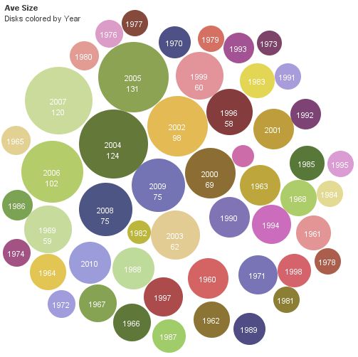
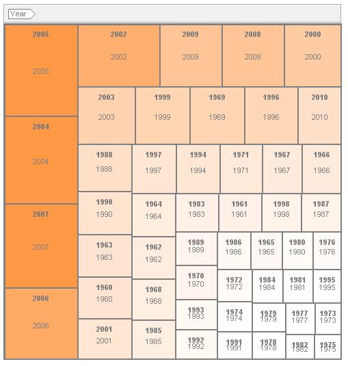
Here are a few new ways of visualizing the average size of wildland fires, in acres, in the United States, from 1960 through 2010. The data for the number of fires and acres burned each year came from NIFC. Then I spent some time with Excel and Many Eyes to develop these products.

Average fire size, 1960-2010, bubble chart
Average fire size, 1960-2010, bubble chart. Data: NIFC/BG
Average fire size, 1960-2010, tree map
Average fire size, 1960-2010, tree map. Data: NIFC/BG
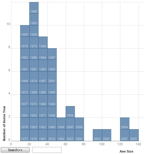
Average fire size, 1960-2010, block histogram
Average fire size, 1960-2010, block histogram. Data: NIFC/BG

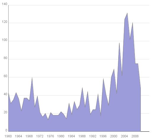
And the standard stack graph:

Average fire size, 1960-2010, stack graph. NIFC/BG
Average fire size, acres, 1960-2010, stack graph. Data: NIFC/BG

The average fire size in 2010 was 48 acres, compared to the average between 1960 and 2010 which was 37.

The chart below shows the average size of wildfires in the United States by decade.

Average size wildfires by decade

Forum: Mountain Pine Beetle and Fire

The following press release was distributed by the Montana Department of Natural Resources and Conservation.

PRESS RELEASE

MOUNTAIN PINE BEETLE & FIRE: THE SCIENCE BEHIND THE RISKS

Helena seminar on May 4th brings in local and national experts

Missoula, MT, April 11, 2011: Much has been debated about the after-effects of Montana’s mountain pine beetle outbreak. Perhaps the largest area of debate centers on wildland fire risk during beetle attack, in the “red needle phase” the “gray phase,” and the “down phase.” Does the mountain pine beetle outbreak correlate to increase wildland fire risk? What type of fire behavior has been observed in the forest post outbreak? What are the long term implications related to fuel loading and future fire behavior?

The Mountain Pine Beetle Forum is hosting the seminar, “Mountain Pine Beetle & Fire: The Science Behind the Risks”, with experts from the scientific and local community whose research and experiences will provide insight on these topics. It will be held at the Red Lion Colonial Inn in Helena on May 4, 2011, with two opportunities to attend: a day-long session with longer, more technical presentations, and a general evening presentation from 6:00pm-9:00pm with the same presenters, but in a more concise, less technical format.

“Everyone is welcome to attend either or both sessions,” said Paula Short, spokesperson for the Montana DNRC who is one of the hosts for the event. “Our desire in providing two sessions was to make it available to both resource professionals and those who could come and spend the day as well as for the volunteer firefighter or private landowner who could only attend after regular business hours.” The event will also be broadcast on the internet, enabling participation by anyone who is unable to travel to Helena.

Presenters include researchers from the University of Idaho, the Missoula Fire Lab, British Columbia Forest Service, and local experts from the U.S. Forest Service, DNRC and the private sector. Complete details can be found at the Mountain Pine Beetle Forum website: http://www.beetles.mt.gov. There is no cost to attend, but an RSVP is requested and can be made by calling the DNRC Forestry Division in Missoula at (406) 542-4300.

This event is sponsored by the interagency Mountain Pine Beetle Forum, the USDA Forest Service Western Wildland Environmental Threat Assessment Center and the Tri-County FireSafe Working Group.

The event will be broadcast live on the Internet.