U.S. Forest Service's "Key Messages"

Posted on Categories Uncategorized

The U. S. Forest Service in California is aggressively trying to get certain messages out about the fire situation in northern California by issuing a laundry list containing 10 “Key Messages“. They took the extraordinary step of having them inserted into the Northern California Geographic Area Coordination Center’s “News and Notes”, which usually contains just the bare facts and numbers about initial attacks and ongoing fires.

This may be in response to allegations by some that the USFS is losing many key firefighters to agencies that have much better pay and benefits packages, leaving the agency in California with too many unfilled positions and unstaffed engines. Here are some samples of the USFS “Key Messages”:

KM1: The Forest Service has over 4,000 firefighters stationed and available in California. They are engaged in aggressive firefighting efforts throughout the state.

KM2: The Forest Service can mobilize resources from other regions and states. We are ordering additional resources with support nationwide. We have even received international assistance from Canada with the Martin Mars aircraft.

(note from Wildfire Today: Wildfire Today reported on the Martin Mars air tanker here. It’s not exactly “international assistance from Canada”. The USFS recently signed it up under contract, just like any other contract resource. On both Friday and Saturday, the 61-year old ship made aborted attempts to fly down from British Columbia but had engine problems before landing on Lake Shasta and returned to Canada using just 3 engines. They will try a third time on Sunday. A Canadian infrared aircraft is also on contract and is being used in northern California, along with the two USFS infrared ships, and UAV’s from NASA, the Air Force, and the Navy.)

KM5: Every Modular Airborne Fire Fighting System (MAFFS) available in the country is currently in California. MAFFS are able to drop up to 3,000 gallons of water.

(“water”? The MAFFS drop long-term fire retardant. There are 6 MAFFS’s working, based out of McClellan. Last year there were approximately 16 large airtankers under federal contracts. This compares to 45+ during the “Siege of ’87”, another huge lightning bust in northern California.)

KM7: We recognize changing conditions and adjust by moving resources accordingly. For example, we may redirect people from one fire to help with another fire. By making progress on the Indians Fire, we were able to send those resources to the Basin Fire, (both on the Los Padres NF) ensuring of course that the firefighters get plenty of rest.

KM8: We are constantly moving, mobilizing and making adjustments on our resources. This is a standard operating procedure. We have been fighting fires successfully for over 100 years. This is what we do best.

(KM7 and KM8 are duplicates. “Moving resources” has been Under Secretary of Agriculture Mark Rey’s answer to the allegations of a lack of adequate resources due to retention problems within the USFS in California.)

KM9: Fuels are extremely dry and research has documented strong links between past climate variability and area burned in wildfires, particularly in the western United States. Projections from climate models suggest that burned areas and fire severity will increase in the future over much of the United States. These changes will affect fire suppression costs and resources, alter ecosystem characteristics, and increase potential fire risk to communities. (*See further approved Climate Change talking points at http://www.fs.fed.us/research/fsgc/briefing-papers/3-CC-FS-and-Fire.pdf

(In other words, “It’s not our fault.”)

California: Basin and Indians fires map and update

Posted on Categories Uncategorized

Indians fire
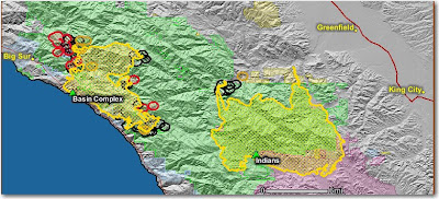
The crews made a lot of progress in the last 24 hours firing along the Arroyo Seco drainage. There was very little activity from the main fire. There is still the possibility that the Basin complex will burn into the Indians fire. A “zone” boundary line has been established between the two fires to clarify responsibilities. The Indians fire is 60,070 acres and 82% contained.

Basin Complex (Gallery and Basin fires)

The fire was very active on the northwest side. They have 16 dozers and 23 crews building line, with some of the lines being in the same places as on the 1977 Marble Cone and 1999 Kirk fires. Highway 1 is still closed to non-residents and evacuations are in place.

The map below shows heat, in red, orange, and black, detected by satellites last night, with the red areas being the most recently burned. The yellow lines are the perimeters uploaded by the incident management teams yesterday. Click on the map to see a larger version.

Smoke from California fires

Posted on Categories Uncategorized

The residents and firefighters in northern California must be hating the air they have been forced to breathe for the past several days. I got a taste of it a while ago here in South Dakota. I smelled forest fire smoke and looked outside and saw that smoke is visible in the air. I checked the current satellite photos and there were no large fires or smoke plumes originating anywhere near the Black Hills.

The new NOAA smoke tracking site has been down for the last 1-2 weeks, but I thought I’d check it on the off-chance it has been fixed. I was pleasantly surprised to see that it is working! And now I know why I’m smelling and seeing smoke.

Click on the map to see a larger version.

Map of Basin and Indians fires

Posted on Categories Uncategorized

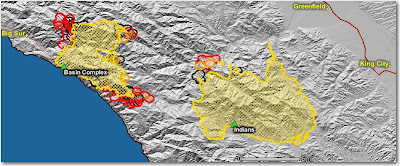
Here is a map of the Indians fire, west of King City, and the Basin Complex (Gallery and Basin fires) south of Big Sur.

The red area on the northwest side of the Indians fire is most likely their firing operation along the Arroyo Seco river.

The map below shows heat, in red, orange, and black, detected by satellites last night, with the red areas being the most recently burned. The yellow lines are the perimeters uploaded by the incident management teams yesterday. Click on the map to see a larger version.


Basin complex update from the U.S. Forest Service last evening:

Firefighters continue to build and improve fireline throughout the east side of the Big Sur area and have been moving toward Manuel Peak. Dozer lines are being constructed along the North Coast Ridge Road south to Dolan Ridge to eventually meet up with the road from the Big Creek State Reserve. Structure protection engines remain in place along Partington Ridge, the North Coast Ridge Road and Highway 1. Today higher humidity at all elevations within the fire has moderated fire behavior due to wind changes.

Indians fire update from the U.S. Forest Service last evening:

The fire did not expand significantly today. The firing operation continued eastward from the Arroyo Seco Campground south of the Arroyo Seco River and good progress was made due to the absence of smoke shading from the Basin Complex Fire and warmer, dryer weather. Good progress was made today improving line along the Rodeo Flats Trail.

Photo of Basin complex courtesy of Alana Cain

Martin Mars expected at Lake Shasta, California

Martin Mars Lake Elsinore, California
Martin Mars at Lake Elsinore, California October 28, 2007. USFS photo by the Air Operations Branch Director.

A Martin Mars water-scooping amphibious air tanker lost an engine yesterday 10 minutes before it was due to land at Lake Shasta in northern California to help with the forest fires. It turned around and flew back to its base at Port Alberni, British Columbia where the engine was going to be repaired or replaced. If the repairs go well, their plan is to land the plane at Lake Shasta at 10 a.m. today, Saturday. But as this is being updated at 7:45 a.m. PT, the aircraft, Canadian number CFLYL, is not showing up on flight tracking.

The aircraft can carry 7,200 gallons of water, Thermogel, or water with a 0.4% solution of foam concentrate. It may be the only air tanker with Thermogel capability. The ship was used for a while last fall in southern California during their fire bust and flew out of Lake Elsinore. This year it will be under contract with the U.S. Forest Service.