Tracked wildland fire vehicle with turbine aided nozzle/mist blower

Can be refilled by helicopter

Arcus Wildtrack
Arcus Wildtrack. Screengrab from the video below.

A company expects to make available soon in the United States a tracked wildland fire suppression vehicle featuring a turbine aided nozzle/mist blower and a 1,300-gallon water tank that can be refilled by helicopter.

“The first demonstrator chassis is ready in Reno, Nevada at Powerbully now and waiting for the turbine to be shipped from Italy by air freight,” Nicholas Davis, CEO of Arcus Fire said. “It will be doing a week-long demo program at Reno during late October. The second demonstrator is also ready for the turbine in Montreal at Prinoth. It will have an HKD Blue turbine on it and will be on display at the Ottawa conference in November and then doing a tour of the provinces.”

Mr. Davis said the price will run around $460,000 to $490,00 depending on options, such as infrared cameras, communications, external lockers, and drone integration. They are also looking at rental or lease options for approximately $7,000 per month.

Below is a press release from Arcus Fire, followed by a video with computer-generated imagery (CGI).


LONDON — JULY 11, 2019

Arcus Fire unveiled an innovative wildland firefighting vehicle today. The Arcus Wildtrack will be able to take the fight to wildfires like no other vehicle currently on the market.

Using equipment provided by world-class manufacturers, a directional variable flow water turbine is combined with a fully-tracked body. The resulting vehicle can throw water, gel or retardant 75 meters at flow rates of 100 to 2,000 liters per minute.

Traveling at 10 kph on a variety of terrain types, the Wildtrack can suppress up to 24 acres per hour, depending on fuel and terrain. Capable of being reloaded by helicopter through its 5,000 liter (1,321 gallon) baffled hopper water tank, the Wildtrack is able to keep moving, continuously laying down suppressant and supporting firefighters with three external Camlock connections for standard fire hoses fed from the water tank.

“The Wildtrack is easy to deploy,” said Arcus Fire CEO Nick Davis. “Two vehicles can fit on a standard flatbed truck and be delivered to the fireline the same as a bulldozer. The Wildtrack also has hard points built into the chassis that allow it to be helicoptered to more remote locations. Using a helicopter which can carry water, such as an S-64 Aircrane or a CH-47 Chinook, the helicopter which delivers the vehicles can also resupply the vehicles from nearby water sources.”

Wildtrack drivers are able to use high-intensity strobes to provide visual cuing to helicopters supporting them, while the driver is provided with Forward Looking Infra-Red (FLIR) vision for safety during night operations.

Real time satellite tracking of the Wildtrack is available, as is a link to a 90-minute endurance Arcus Drone with survey repeater beamed into the cab for a bird’s-eye view of the situation on the ground.

“We will offer different leasing programs to organizations and agencies which wish to contract the Wildtrack,” Davis added. “Following the 2018 fire season in the U.S., in which millions of acres burned, billions of dollars of real estate was destroyed, and over 100 lives were lost, my vision is that I would like to be able to reduce losses to less than $1 billion, with only a few structures lost and no loss of life within 5 years’ time.”

“The Arcus Wildtrack apparatus brings some new and old concept ability to assist wildland firefighters in suppressing wildfires. I look forward to seeing the Arcus Wildtrack go from concept to prototype and seeing it in action in 2020,” said Chief Kim Zagaris, Western Fire Chiefs Association Wildfire & Policy Advisor.

Four new wildfires break out in Nevada and Idaho

Two people were arrested for allegedly starting the Jasper Fire north of Reno by target shooting into an area with cheat grass

Jasper Fire north of Sun Valley, Nevada
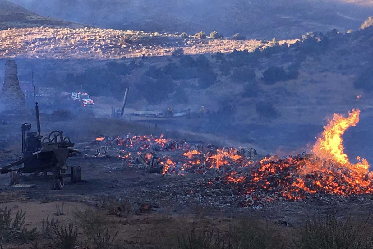
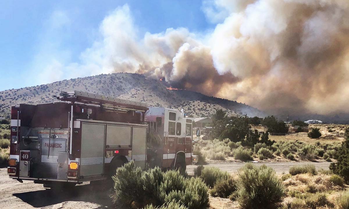
The Jasper Fire north of Sun Valley, Nevada. Photo by Truckee Meadows Fire Protection District, July 13, 2019.

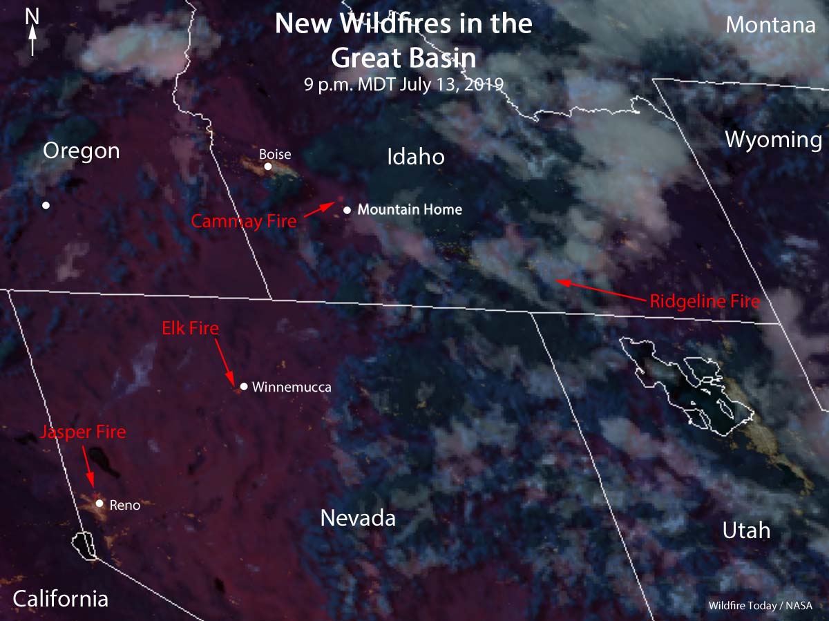
Four new wildfires broke out in the Great Basin Geographic Area late Saturday, two each in Idaho and Nevada.

satellite four fires Idaho Nevada wildfires
The GOES 17 satellite detected four fires in Idaho and Nevada at 9 p.m. MDT July 13, 2019. The imagery is enhanced to show heat from the fires. Click to enlarge.

Jasper Fire

The Jasper Fire was reported at about 3 p.m. north of Sun Valley, Nevada. The Washoe County Sheriff’s Office asked for voluntary evacuations in the Sun Valley area as the fire reached Eagle Canyon Drive. The Truckee Meadows Fire Protection District reported that the fire burned about 800 acres. By Sunday morning the blaze was producing very little smoke, but at least one outbuilding was destroyed Saturday.

Jasper Fire north of Sun Valley, Nevada
The Jasper Fire north of Sun Valley, Nevada. Photo by Truckee Meadows Fire Protection District, Saturday evening July 13, 2019.

Washoe County Sheriff Darin Balaam said Alex Javier Arias, 23, and Jorge Arias, 22, were arrested for starting the fire by target shooting into cheat grass. They could be charged with destruction of property caused by fire through gross negligence which is a felony, Sheriff Balaam said.

Air tankers and helicopters assisted firefighters, including at least one air tanker, Tanker 88, from CAL FIRE.

A Type 3 Incident Management Team, Sierra Front with Incident Commander Stephenson, was scheduled to in-brief at 6 a.m. Sunday, according to @GreatBasinCC.

Ridgeline Fire

As of Saturday evening the Ridgeline Fire, 5 miles northeast of Albion, Idaho had burned about 1,000 acres and was running and spotting in juniper and brush. It was being fought by firefighters on the ground assisted by four Single Engine Air Tankers and a DC-10.

The impressive video below of a DC-10 dropping was tweeted by @BLMIdahoFire July 13, 2019 but they did not say when or where it occurred. It may have been at the Ridgeline Fire 5 miles northeast of Albion, Idaho the same day.


Elk Fire

The Elk Fire burned about 30 acres south of Winnemucca, Nevada.

Canmay Fire

The Canmay Fire, 8 miles north-northwest of Mountain Home, Idaho started on Bureau of Reclamation land eight miles northwest of Mountain Home, ID. Saturday evening it was running, flanking, and creeping through brush and short grass and had burned about 2,000 acres.

The weather forecast

The weather forecast for Sunday on the Jasper, Elk, and Canmay Fires are all about the same —  temperature in the 90s with wind speeds over 10 mph. It will be a little cooler on the Ridgeline Fire with the temperature in the 80s, and winds less than 10 mph.

“Into the Fire”, a new film about the Camp Fire

The fire burned through Paradise, California November 8, 2018

film Camp Fire into the fire

The California Department of Forestry and Fire Protection has released a new 17-minute film about the 2018 Camp Fire, the blaze that killed 85 people, blackened 153,336 acres, and destroyed 18,804 structures.

It is titled Into the Fire: The First Hours of the Camp Fire, and was uploaded to YouTube Wednesday.

Thanks and a tip of the hat go out to John. Typos or errors, report them HERE.

Coldtrailer detects heat during mopup without bending over

Coldtrailer
The ColdTrailer panel, shown with a 12-inch ruler. Click to enlarge.

Today we are officially welcoming one of the most recent sponsors of Wildfire Today. The ColdTrailer can detect hot spots during mopup without a firefighter having to bend over or get on their hands and knees.

The story

In 1984 Jim Mundt, a McCall, Idaho based smokejumper, began thinking about a better way to find the last burning embers on a wildfire during mopup, the last task required before a fire could be declared out so the jumpers could abandon the fire, return to their base, and get back on the jump list. In 2000, working with his brother who was an electrical engineer, they developed the first prototype of a heat sensor mounted at the end of a pole. When the sensor detected heat, a speaker emitted a tone which changed as the temperature rose.

They worked on it for a couple of years, fine tuning the device and applying for a patent, but by then Jim was no longer a firefighter and the project languished.

Fast forward to 2017 when Patrick Wood, a crew member on the Los Padres Hotshots, came up with the same idea. When he researched the topic he found the Mundt brothers patent. The three of them began collaborating and are now making the ColdTrailer available to all wildland firefighters.

Coldtrailer
ColdTrailer, with a 12-inch ruler.

Field testing season

In 2018, 60 of the ColdTrailer MK 1’s were used by 20 crews, including 13 hotshot crews. The following are quotes from crewmembers on the Palomar Hotshots: “Saves our backs and hands from conventional cold trailing”,  “Very effective and easy to use cold trailing tool”, “Don’t have to bend over to hand feel the dirt” “The sensitivity was good and picked up even the smallest hotspots”, “Keeps you from potentially burning yourself”.

How it works

According to the company, the ColdTrailer functions very similarly to your hands and very differently from infrared technology. When barehanded cold trailing, any warmth detected is an indication of a possible hot spot so a firefighter must feel around to find the source of the heat.

With the ColdTrailer warmth is indicated by beeps. The faster the beeps the warmer it is getting. When the rate of beeps increases, the firefighter should spend a little more time checking that area for a real hot spot.

When the firefighter sweeps the probe through a hot spot the beeps get really fast, the LED flashes red, and a vibrating alarm pulses in the handle. The ColdTrailer can be used both to probe deep into root holes and also to sweep through the ash or duff right on the fire perimeter.

Why infrared is not a replacement for cold trailing

The company believes it is necessary to use a conduction-based heat sensor for cold trailing because infrared devices read surface temperatures, and ash is an insulator. Firefighters who use infrared as a replacement for cold trailing risk missing hot spots (unless in light fuels with a minimal ash layer).

Specs

The current version, the Coldtrailer MK. 2, is 4 feet 10 in. inches long when in use. Stored, the six sections fold like tent poles into a 12-inch package weighing less than a pound — 15 ounces. The six sections have a Kevlar cord strung through them keeping everything in the right order when it is folded. Inside the cord are two small electrical wires that run from the sensor to the control box. Assembling takes 15 to 20 seconds after you’ve done it once or twice.

Ergonomic design

The ColdTrailer has a strap that holds the six sections together when it’s folded. After the unit is assembled the strap is used to attach the upper end of the pole to the user’s arm while your hand grips it farther down on a foam pad. The two points of control provide leverage as the temperature-sensing end is dragged through ash on the ground.

Battery

One charge of the battery, which can be accomplished through a micro USB cable, lasts several months, according to the company. Lights indicate when the battery has 25% or 10% charge remaining. It shuts off after 10 minutes of not being used. There is a very, very small removable plastic plug which seals the charging port.

Price

The Coldtrailer MK. II sells for $450. [There is a 15% discount if you buy 4 or more and a 25% discount if you buy 10 or more. They are available from the Supply Cache, Forestry Suppliers, and at the company’s website. International buyers should order from Forestry Suppliers or the Supply Cache. A 90 day risk-free trial is available for those who purchase through the company’s website.

Final analysis

Without the opportunity to use it on a fire I can’t say for certain that the ColdTrailer is a good investment, but if it works as intended, firefighters could cover ground more quickly during mopup while reducing the stress on their backs and knees during the tedious search for hotspots.

Rain slows spread of 23,000-acre Shovel Creek fire northwest of Fairbanks

South Idaho Hotshots
South Idaho Hotshots on the Chatanika River assigned to the Shovel Creek Fire in Alaska. InciWeb. Click to enlarge.

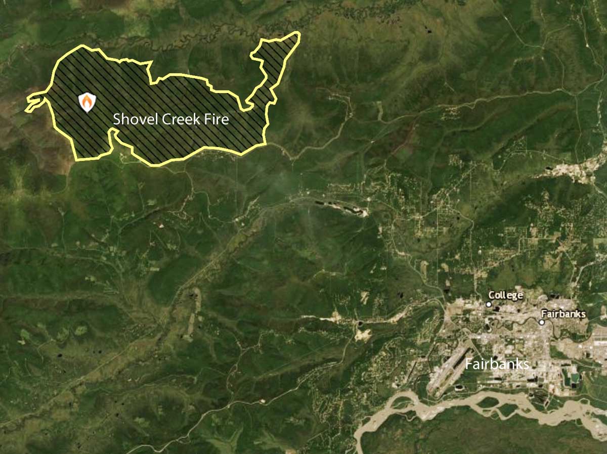
The Shovel Creek Fire, started by lightning about three weeks ago, has spread to about 20 miles northwest of Fairbanks, Alaska. As of July 12 it had burned 23,734 acres and was described as “smoldering” due to recent rain.

The number of personnel assigned dropped yesterday by 118, to bring the total down to 621. That number includes 13 crews, 18 engines, and 7 helicopters. So far $17.8 million has been spent on suppressing the fire.

Crews continued to make progress Friday with mop-up operations on the western and southern fire lines, securing the fire’s edge near Murphy Dome and along portions of the scar from the 2009 Hardluck Fire. Saturday, firefighters will continue mop-up along Old Murphy Dome road and the ridge line north of Perfect Perch to the Chatanika River.

During this break in fire behavior due to the weather, crews have taken the opportunity to scout for fire line opportunities along the Chatanika River north of the fire. As work to secure the northern edge continues, firefighters have kept hose lays, sprinklers, and other equipment in place around the structures along the Chatanika River. Aerial resources will continue to be available to cool hotspots near fire lines, as smoke and fog conditions allow.

Map Shovel Creek Fire July 12, 2019
Map of the Shovel Creek Fire July 12, 2019.

The rain in the area has cleared some of the smoke. With fire activity north and east of Fairbanks, forecasting air quality continues to be a challenge. Fairbanks Memorial Hospital created a 24-hour smoke respite center in the Chandler Room at 1650 Cowles Street, Fairbanks, AK 99701.

Wildfire on Maui causes evacuations, burns 10,000 acres

wildfire on Maui Thursday
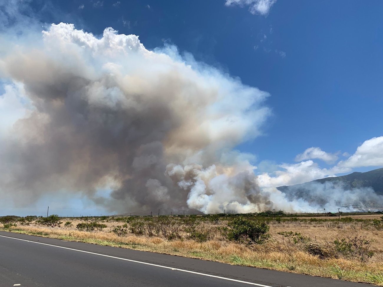
A wildfire on Maui Thursday burned 10,000 acres and forced thousands of people to evacuate. Photo courtesy of the County of Maui.

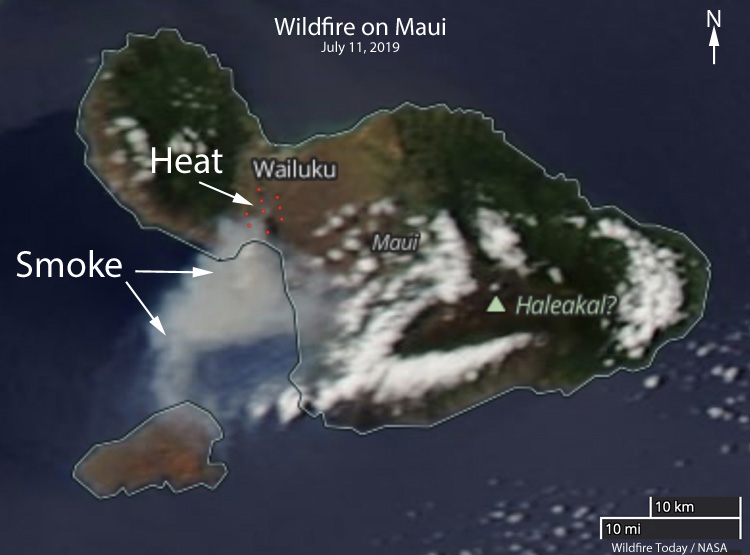
A wildfire that erupted Thursday morning on the Hawaii island of Maui burned 10,000 acres and forced thousands to evacuate. Most of the residents returned to their homes Thursday night but the fire is still active in places.

Reported at 10:42 a.m. near the intersection of Waiko Road and Kuihelani Highway, the blaze quickly jumped the Kuihelani Highway, while pushed by 15 to 20 mph winds.

wildfire Maui detected by satellite july 11 2019
Wildfire on Maui detected by a satellite, July 11, 2019.

The Fire Department’s two helicopters, Air One and Air Two, dropped water, and private companies and the County Department of Public Works made their dozers available.

The Maui Humane Society evacuated about 200 animals.

For a while Thursday The Kahului Airport lost commercial power and was running on generators. Incoming flights were diverted and 11 motor coaches and school busses were standing by at the airport in case visitors had to be evacuated to shelters.

Roads that had been closed, North Kihei Road, Kuihelani Highway, and Maui Veterans Highway reopened Thursday night.

Opra Winfrey, who owns a home on Maui, allowed County officials access to her private road.

Thanks and a tip of the hat go out to Tom. Typos or errors, report them HERE.