Prince Harry spoke about mental health to farmers, but it could have been firefighters

Prince Harry has opened up to farmers about his own mental health struggles. “Asking for help was one of the best decisions that I ever made.”

Prince Harry and Meghan Markle
Prince Harry and Meghan Markle. From ABC News video.

While on a trip to Australia Prince Harry and Meghan Markle stopped to talk with farmers who are suffering through a severe drought which has led to a cascading series of hardships. In drawing upon his own experience with depression he implored them to find someone to talk to.

His words would have been very appropriate before an audience of wildland firefighters — from January 1, 2015 through November 1, 2017 at least 68 took their own lives.

If you substitute “firefighter” for “farmer” in Prince Harry’s address, it would still be very appropriate.

Help is available for those feeling really depressed or suicidal.

Has Yellowstone “recovered” from the 1988 wildfires?

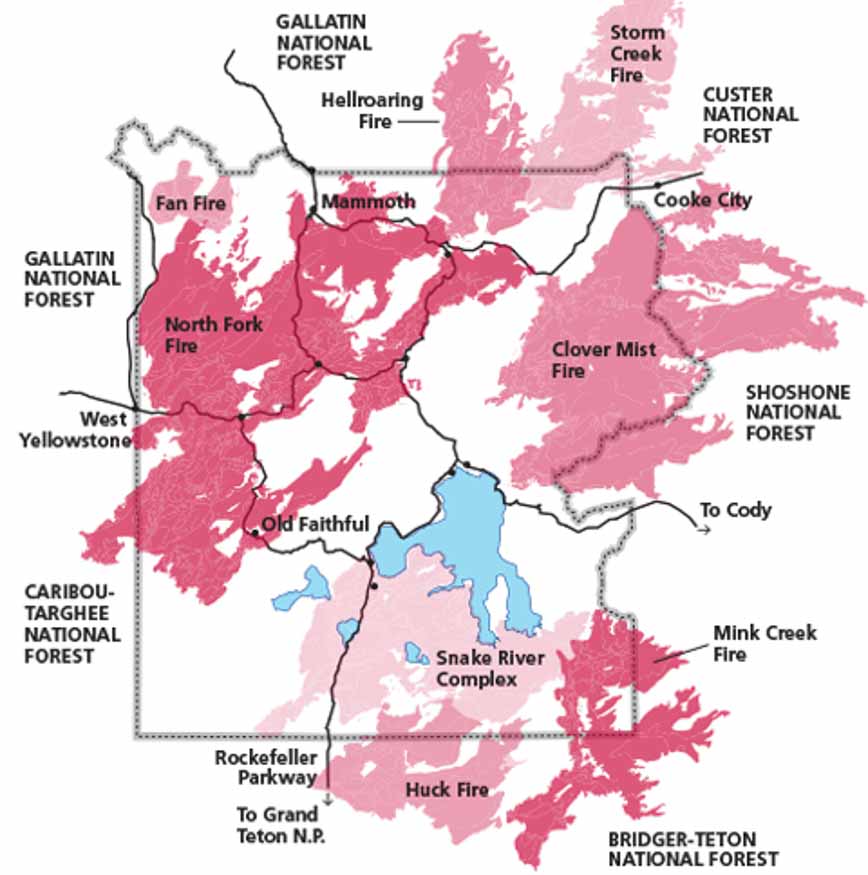
Yellowstone National Park 1988 wildfires
Yellowstone National Park fires in 1988. NPS.

We often hear about an area “recovering” from a wildfire. This implies that fire is unfortunate and unwelcome, a sentiment probably based on an instinctive fear. And it should go without saying — fires that burn structures or humans fit that description.

But vegetation fires in remote areas should be evaluated with different criteria. Yes, a fire can drastically change the appearance of a landscape. Most people visiting national parks, for example, would prefer to take pictures of a mature green forest than a recently burned hillside that is beginning a new fire return cycle. But those two ends of the cycle and everything in between are natural.

In 1988 fires in Yellowstone National Park caused mostly by lightning burned 793,880 acres, 36 percent of the park, during windy weather following a dry spring and summer. Today I saw an article that was focused on to what degree the vegetation had “recovered” from those fires 30 years ago. The emphasis was how much the landscape looked like it did before the fires of 1988. One might say that a lodgepole forest that burned at the end of its 50 to 300 year fire return interval had recovered the day after the embers cooled.

The photo below taken in 2003 in Yellowstone National Park in an area that burned in 1988 shows the regrowth of the forest in just 15 years.

yellowstone, thermal feature, trees,
Steam rises from a new Yellowstone National Park thermal feature in an area burned 15 years after the 1988 fires. The brown trees were killed by the sudden development of the high temperatures. Photo by Bill Gabbert, September 14, 2003.

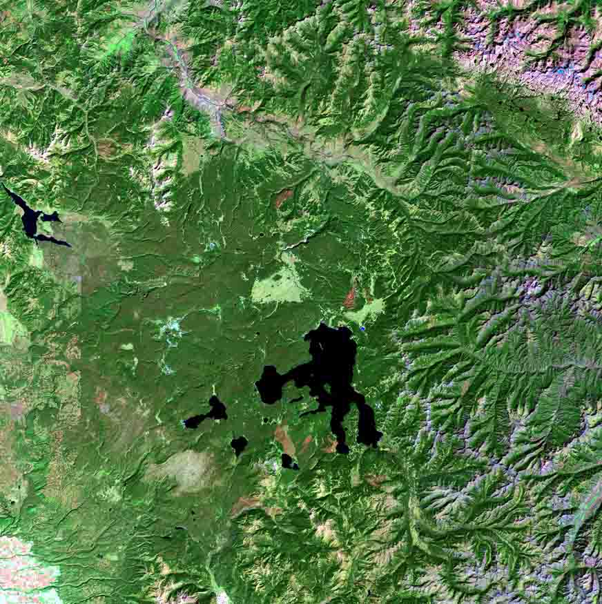
Below are satellite photos provided by the US Geological Survey of the Yellowstone area taken a year before, just after, and 30 years after the 1988 fires. The red areas are not the actual color of the vegetation, but represent the areas where the fires burned, as detected by shortwave infrared, near-infrared, and visible green sensors on a satellite. As the vegetation changes, light green areas start replacing the red and pink from the burn scar.

Yellowstone National Park 1988 wildfires
September 22, 1987

Continue reading “Has Yellowstone “recovered” from the 1988 wildfires?”

Residents forced to evacuate near Garden Route Fire in South Africa

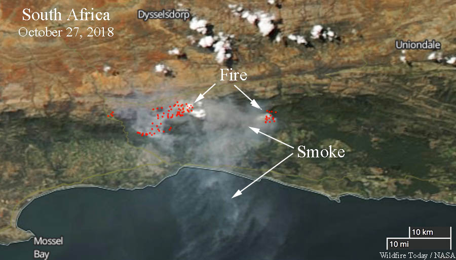
Fires in South Africa. Satellite image
Fires in South Africa. Satellite image from October 27, 2018. NASA.

Firefighters in South Africa have been busy for the last week battling large wildfires. A week ago a helicopter pilot was killed while working on one of the fires.

Below is an excerpt from an article in The South African, October 29, 2018.


A fierce Garden Route fire has engulfed part of the Outeniqua Mountain range near George, leading residents to evacuate homes and smallholdings.

The blaze, which began over the weekend, has been fanned by scorching temperatures and strong winds. George Municipality has initiated voluntary evacuation procedures for residents in the danger zone, which is currently regarded as the northern outskirts of the nearby town.

George fire causes panic as residents evacuate.

On Monday morning, George Municipality issued an evacuation warning for residents on the outskirts of town. Residents of Blanco Golden Valley and Stepaside were urged to vacate their homes as a precautionary measure.

The local traffic department and the South African Police Service (SAPS) are currently assisting residents in the area, ushering them to safety at the Town Hall. Residents of Heatherlands and Fernridge in George have also been urged to evacuate their properties and find shelter at the Blanco Community Hall.

PG&E to patrol power lines with aircraft this weekend

PG & E pacific gas and electricFollowing reports that at least 12 of the wildfires that devastated areas of the California wine country last year were caused by Pacific Gas & Electric power lines, the company has decided to initiate helicopter patrols. The aircraft will inspect lines in El Dorado County in the areas of Camino, Cedar Grove, Pollock Pines, Sly Park, Newtown, Old Fort Jim, Sierra Springs, Pleasant Valley, Sweeneys Crossing and Happy Valley through October 28.

The National Weather Service predicts breezy conditions and elevated wildfire danger in some areas of Northern California Sunday and also Tuesday through Thursday of next week.

In the past PG&E has contracted for at least one Blackhawk helicopter that they use for heavy lift operations.

Blackhawk helicopter PG&E
Blackhawk helicopter under contract to PG&E.

In July of 2017 a helicopter under contract to PG&E crashed near Donner Summit in California.  The CHP said the six people on board had only minor injuries and none were transported to a hospital.

PG&E helicopter crash
Crash of helicopter under contract to PG&E July 11, 2017. near Donner Summit. CHP photo.

Wildfires can be part of a series of cascading events

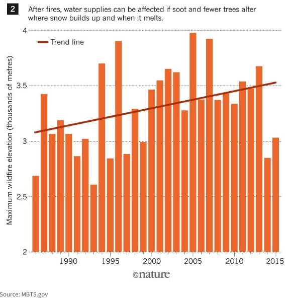
Maximum Wildfire Elevation
Maximum Wildfire Elevation. MBTS & Nature.

In the natural world one environmental event or disturbance can initiate or be part of a series of cascading events that intensify the impacts of natural hazards, possibly turning them into disasters.

An article at The Conversation explores how these effects can be enhanced by a warming climate. Below is an excerpt from an article written by Amir AghaKouchak (UC Irvine) and Farshid Vahedifard (Mississippi State University).


“Multiple hazardous events are considered cascading when they act as a series of toppling dominoes, such as flooding and landslides that occur after rain over wildfires. Cascading events may begin in small areas but can intensify and spread to influence larger areas.

[…]

“Also, the severity of these cascading weather events worsens in a warming world. Drought-stricken areas become more vulnerable to wildfires. And snow and ice are melting earlier, altering the timing of runoff. This has a direct relationship with the fact that the fire season across the globe has extended by 20 percent since the 1980s. Earlier snowmelt increases the chance of low flows in the dry season and can make forests and vegetation more vulnerable to fires.

“These links spread further as wildfires occur at elevations never imagined before. As fires destroy the forest canopy on high mountain ranges, the way snow accumulates is altered. Snow melts faster because soot deposited on the snow absorbs heat. Similarly, as drought dust is released, snow melts at a higher rate, as has been seen in the Upper Colorado River Basin.

[…]

“When landscapes are charred during wildfires, they become more vulnerable to landslides and flooding. In January, a debris flow event in Montecito, California killed 21 people and injured more than 160. Just one month before the landslide, the soil on the town’s steep slopes were destabilized in [the Thomas Fire]. After a storm brought torrential downpours, a 5-meter high wave of mud, tree branches and boulders swept down the slopes and into people’s homes.”


More Information