Firefighters hope to prevent the County Fire from crossing Hwy. 128

The fire has blackened approximately 82,700 acres

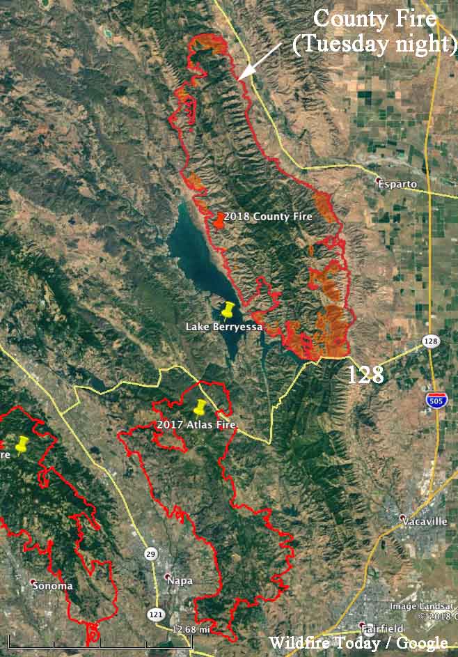
Above: The map shows the southern end of the County Fire where firefighters are working to keep it from crossing the narrow sections of Lake Berryessa and Highway 128. The red shaded areas represent intense heat observed during a Tuesday night mapping flight.

(Originally published at 8:19 a.m. PDT July 4, 2018)

During the first two days the County Fire 26 miles west of Sacramento burned about 1,000 acres an hour, but that spread has slowed recently as firefighters have has success, but difficult terrain in some areas has presented a challenge. The fire has blackened approximately 82,700 acres.

One of their main priorities is to keep the fire from moving south across Highway 128. The map above shows they have made progress toward that goal. If it spreads across the highway it would threaten many homes in the Allendale and Vacaville area. If it grows around the southern tip of Lake Berryessa it could burn into the footprint of last October’s Atlas Fire, northeast of Napa, where the resistance to suppression would decrease dramatically.
county fire map
Map showing the perimeter of the County Fire, Tuesday night.

Spring Creek Fire becomes third largest in state history

It has burned approximately 94,093 acres, displacing the High Park Fire for the number three position.

Above: A DC-10 drops retardant on the Spring Creek Fire. Undated photo by Garfield County Sheriff’s Office.

(UPDATED February 21, 2019)

The Spring Creek Fire ultimately burned 108,045 acres and 141 homes, becoming the third largest in the recorded history of Colorado. A Danish man living in the United States on an expired visa was charged with 141 counts of first-degree arson for allegedly starting the fire — one charge for each of the homes destroyed.


(UPDATED at 12:37 p.m. MDT July 5, 2018)

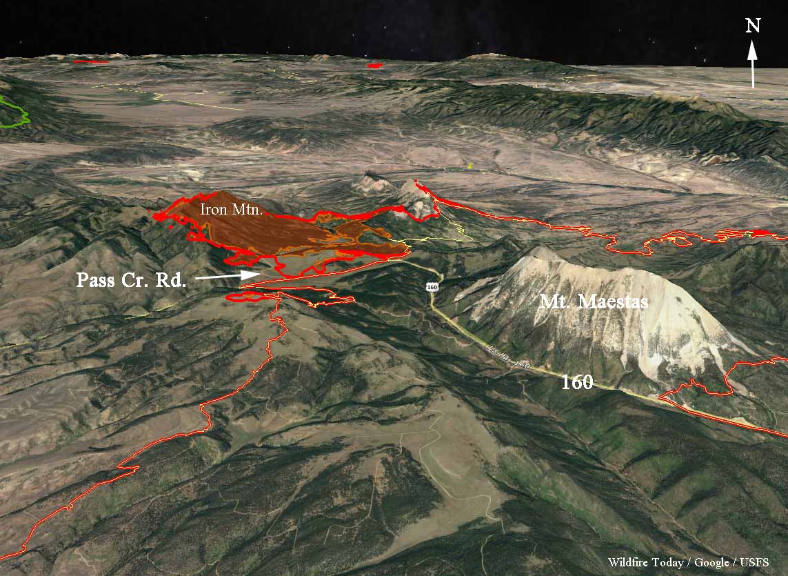
The Spring Creek Fire was very active Wednesday and Wednesday night spreading in a direction we have not seen very often since the fire started June 27. It spread rapidly on the northwest side running two to four miles west of Pass Creek Road working its way up Iron Mountain. It is unknown how far it may have continued after reaching the top. Clouds made it difficult to get good infrared data in that area.

The fire has burned approximately 103,000 acres as of early Thursday morning.

map spring creek fire
3-D map of the northwest section of the Spring Creek Fire, looking north, showing data from 12:46 a.m. MDT July 5, 2018.

Here is the outlook provided by the Incident Management Team:

Atmospheric moisture will continue to increase through the end of the week. However, given the current fuel conditions, the fire will continue to follow heavy continuous fuels to the north towards Gardner, the northeast towards Badito, to the east towards Three Bridges, to the south towards Cuchara and Indian Creek regardless of general wind direction. Potential for scattered thunderstorm activity which can cause gusty outflow winds in any direction.


(Originally published at 8:11 a.m. MDT July 4, 2018)

The Spring Creek Fire in southern Colorado between La Veta and Fort Garland added another 15,000 acres Tuesday to become the third largest in the recorded history of the state after Tuesday night’s mapping estimated that it has burned approximately 94,093 acres. A partial cloud cover made 100% precision impossible.

The five largest:

  1. Hayman Fire in 2002, 137,760 acres, NW of Colorado Springs
  2. West Fork in 2013, 110,405 acres, Wolf Creek Pass
  3. Spring Creek in 2018, 94,093 acres (preliminary mapping, still spreading) La Veta
  4. High Park Fire in 2012, 87,284 acres, west of Ft. Collins
  5. Missionary Ridge Fire in 2002, 71,739 acres, Durango

CLICK HERE to see all of the articles on Wildfire Today about the Spring Creek Fire.

Continue reading “Spring Creek Fire becomes third largest in state history”

County Fire expands to 70,000 acres

Approaches Solano County

Above: The currently burning County Fire is shown along with other large fires from last year.

(Originally published at 12:55 p.m. PDT July 3, 2018)

The County Fire in Napa and Yolo Counties continued to grow Monday and Monday night, chewing up more vegetation on the west and southeast sides.

It has moved to within two miles of the Solano County line. If it proceeds beyond that and across Highway 128 it would threaten many homes in the Allendale and Vacaville area. If it grows around the southern tip of Lake Berryessa it could burn into the footprint of last October’s Atlas Fire, northeast of Napa, where the resistance to suppression would decrease dramatically.

CAL FIRE announced Tuesday that the County Fire had burned about 70,000 acres.

The fire is being battled by 2,162 personnel, including 187 engines, 56 hand crews, 18 helicopters, 50 dozers, and 51 water tenders.

Maps of Spring Creek Fire, July 3, 2018

Above: 3-D map of the Spring Creek Fire looking northwest.

(UPDATED at 12:57 p.m. MDT July 3, 2018)

The area where the Spring Creek Fire is located in south-central Colorado is under a Red Flag Warning today. At around noon a weather station near La Veta was recording temperatures in the mid-eighties, 9 percent relative humidity, and winds out of the west at 15 mph. On Wednesday the conditions should be similar, but with slightly higher humidity.

Tuesday afternoon the Incident Management Team changed their reported  size of the fire to 78,941 acres — up from 60,710 earlier today.


(Originally published at 8 a.m. MDT July 3, 2018)

The Spring Creek Fire is burning homes and devastating tens of thousands of acres of private land 17 miles west of Walsenburg, Colorado. San Luis Valley 911 tweeted Monday night that 104 homes have been destroyed in the Forbes Park area.

Since it started June 27 it has blackened 60,710 acres, according to the official information from the Incident Management Teams Monday night. Our VERY UNOFFICIAL estimate is that at least 75,000 acres have burned as of early Tuesday morning.

CLICK HERE to see all of the articles on Wildfire Today about the Spring Creek Fire.

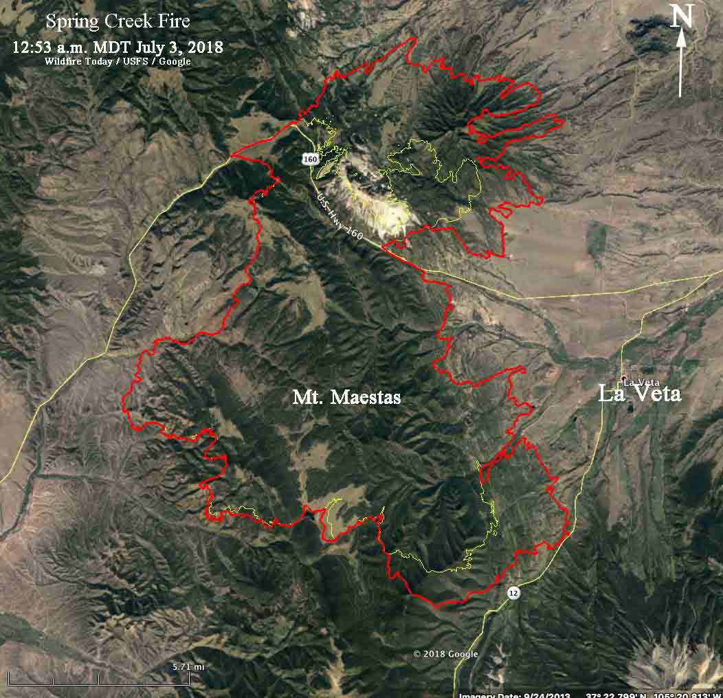
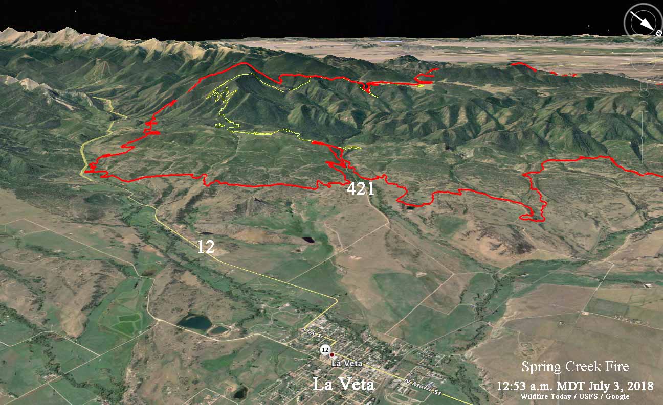
These maps were made with Google Earth using fire perimeter data collected at 12:53 a.m. MDT July 3, 2018 (the red line) by a U.S. Forest Service mapping aircraft. The yellow line was the perimeter about 24 hours before.  We hope they will answer a few questions for local residents about which areas are within the burned perimeter. Of course if they are, it does not mean that the structures have been destroyed. Firefighters have no doubt worked hard to save many.

map Spring Creek Fire
Map of the Spring Creek Fire.
map Spring Creek Fire
3-D map of the Spring Creek Fire looking southwest.

Continue reading “Maps of Spring Creek Fire, July 3, 2018”

Person arrested for arson in Spring Creek Fire is in the US illegally

Jesper Joergensen
Jesper Joergensen

According to the Denver Post in a story published today the person who has been arrested for arson related to what is now the 56,820-acre Spring Creek Fire in south-central Colorado is in the United States illegally. Jesper Joergensen, who holds a Denmark passport, had a visa which has now expired.

Costilla County sheriff’s deputies are working on the case with U.S. Immigration and Customs Enforcement personnel.

Below is a statement from the  Sheriff’s office released on June 30:

The initial cause of the fire was human caused. The investigation was lead by our office with the assistance of CBI, State arson investigators, CSP, and Immigration and Customs agents. Jesper Joergensen, 52, was arrested without incident by Costilla County deputies. Jesper is being held on Arson charges. The investigation is still on going so information on this matter is limited.

The Denver Post article mentions that the arrest warrant said about 25 homes had been destroyed in the fire, but fire officials on Monday are reporting that no structures have burned.


CLICK HERE to see all of the articles on Wildfire Today about the Spring Creek Fire.