BLM to develop EISs for fuel breaks and fuel reduction

The programmatic Environmental Impact Statements would streamline approvals for projects

Above: A fuel break created along a road by mowing. BLM photo.

(Originally published at 9:55 a.m. MDT December 30, 2017)

In May the U.S. Geological Survey began an effort to study fuel breaks in the Great Basin to evaluate their effectiveness as well as the ecological costs and benefits. On December 22 the Bureau of Land Management announced the agency is proposing to develop two Environmental Impact Statements (EIS) for BLM lands in the states of Idaho, Oregon, Nevada, California, Utah, and Washington. One will cover the construction of fuel breaks while the other is for fuels reduction and rangeland restoration.

The process is expected to result in two programmatic EIS documents that would cover projects region-wide to gain efficiencies in subsequent National Environmental Policy Act (NEPA) analyses. The blanket approval will mean that individual landscape-scale fuel breaks and fuel reduction proposals will only need minor additional environmental reviews to proceed.

Fuel breaks are intended to interrupt the continuity of vegetation making it easier to control or stop the spread of wildfires. There is no guarantee of success since wind-blown burning embers can be lofted hundreds or thousands of feet ahead of a flaming front, crossing the breaks.

fuel break herbicide aerial application
An aircraft sprays herbicide on a BLM fuelbreak. BLM image.

Landscape-scale fuel reduction would slow the spread and reduce the intensity and resistance to control of a wildfire making it easier for firefighters to keep a small fire from becoming a megafire. Another goal of the vegetation modification is to restore the rangelands habitat in order to provide multiple use opportunities for user groups and habitat for plants and animals. The projects are designed to reduce the threat of habitat loss from fires and restore rangeland’s productivity while “supporting the western lifestyle”, the BLM said in a statement.

The public has until February 20, 2018 to submit comments related to the programmatic EISs by any of the following methods:

  • Website: https://go.usa.gov/xnQcG
  • Email: GRSG_PEIS@blm.gov.
  • Fax: 208–373–3805.
  • Mail: Jonathan Beck, 1387 S. Vinnell Way, Boise, ID 83709
BLM fuel break
BLM fuel break. BLM photo.

Secretary of Interior used wildfire funds for helicopter tour of National Monuments

The tour was prior to deciding which monuments to shrink

Before Secretary of the Interior Ryan Zinke made his recommendation to the President about which National Monuments to shrink, he used wildfire preparedness funds appropriated to the National Interagency Fire Center office in Boise to pay for helicopter flights over sites in Nevada.

According to an article in Newsweek by Celeste Katz, the use of the helicopter on June 26, 2017, which cost taxpayers and the Bureau of Land Management $39,295, was unrelated to wildland fire. The account used for the flights is designated for fire personnel salaries and equipment.

Below is an excerpt from the article:

But after Newsweek questioned the line item, an Interior Department spokeswoman said this week that the chopper—listed in an accounting of Zinke’s travel as costing $39,295—“was charged to the account in error.” She added that the BLM would pay for the helicopter from “a more appropriate account.”

The official purpose of the round-trip helicopter trip was for an “aerial survey of objects and boundaries pertaining to the 704,000 acres in Basin and Range National Monument and the 300,000 acres in Gold Butte National Monument.”

From Newsweek:

Zinke ultimately recommended shrinking not only Gold Butte in Nevada but other Western national monuments, including Bears Ears in Utah and Cascade-Siskiyou in Oregon and California. His Gold Butte recommendation angered conservationists but was hailed by Nevada Senator Dean Heller and the head of a local water district.

The National Incident Management Situation Report published on June 27, 2017, the morning after the helicopter tour, showed two large wildfires burning in Nevada, the Cole Creek and Dolly Fires, but Secretary Zinke did not visit any fires on his trip. The report showed that in the Great Basin Geographic Area, which includes Nevada, 16 helicopters were working on 21 fires, with 54 helicopters in use nationally.

Secretary Zinke has been criticized for using military, chartered, and National Park Service fixed and rotor wing aircraft, at times for purposes that could be difficult to justify.

The Department of the Interior supplied a list of some of the Secretary’s use of non-commercial aircraft, but it does not include a trip with Agriculture Secretary Sonny Perdue to Boise on August 24 on an Air Force plane similar to a Boeing 737.

Ryan Zinke air force aircraft 737

Mapping defensive actions and exposure at the 2017 california Tubbs Fire

How effective were firefighters’ defensive actions in limiting the destruction?

The very detailed analysis below documents in a “story map” format the locations of structures that were completely destroyed or damaged when the Tubbs Fire ran through Santa Rosa, California October 8, 2017.

A primary emphasis of the analysis highlights defensive actions taken by firefighters or others. It shows structures that were only damaged on the periphery of areas that experienced total destruction. The conclusion is that the protected “boxed in” structures show successful halting of the worst effects of the fire due to exposure and defensive actions. That could be the case, however there are many factors that affect the spread of a fire in an urban environment.

We thank Geospatial Measurement Solutions, LLC who put this mapping product together. Derek McNamara, owner, said by email:

As our firefighters continue to put their lives at risk to protect all of us and fires continue to rage in Southern California, I thought it pertinent to show what they face in these situations, the consequences of their actions, and what might happen without them. I have observed that firefighters take these losses to heart and I hope this gives them some validation of their unbelievable efforts.

Hazardous tree on the White House lawn

Firefighters would not work under this tree.

Above: The historic Jackson Magnolia can be seen on the left in this November 6, 2004 photo by William Phillips.

(Originally published at 12:30 p.m. December 27, 2017)

Firefighters who work in the woods, worry about hazardous trees, or double as arborists will be interested in what is happening to to a nearly 200-year old magnolia tree on the White House lawn. Planted by Andrew Jackson in memory of his wife who died days after the 1828 election, it is the oldest tree on the 18 acres surrounding the building.

For the last decade or two it has been literally on life support held up by a steel post and a network of cables. The attachment points for the cables are deteriorating and much of the interior of the two trunks are rotten. The tree is near the location where the press is penned in when covering the departure of the President on Marine 1, the large Sikorsky SH-3 Sea King helicopter. The reporters should be wearing hard hats, but that would not be enough protection if the rotor wash brings down the hazardous tree.

The Magnolia grandiflora, commonly known as the southern magnolia or bull bay, is native to the southeastern United States from coastal North Carolina to central Florida, and west to East Texas and Oklahoma.

Specialists from the United States National Arboretum were brought in to assess the once magnificent tree. Their report said in part:

The overall architecture and structure of the tree is greatly compromised and the tree is completely dependent on the artificial support. Without the extensive cabling system, the tree would have fallen years ago. Presently, and very concerning, the cabling system is failing on the east trunk, as a cable has pulled through the very thin layer of wood that remains. It is difficult to predict when and how many more will fail.

Jackson magnolia white house
Screen shot from CNN video

While the President is away during this holiday week a large portion of the tree is being removed. One of the two trunks was cut down Wednesday morning. Both are rotten inside and the remaining trunk will eventually also have to be removed.  Mrs. Trump, who assessed the condition of the tree and approved the removal, asked that the wood be saved.

From CNN:

The circle of life

However disappointing the removal of the Jackson Magnolia, the silver lining of its demise is that White House groundskeepers were prepared. For several months, at an undisclosed greenhouse-like location nearby, healthy offshoots of the tree have been growing, tended to with care and now somewhere around eight to 10 feet tall. CNN has learned the plan is that another Jackson Magnolia, born directly from the original, will soon be planted in its place, for history to live on.

Jackson magnolia white house

Not all wildland firefighting gear works well for women

Above: The Mt. Taylor Hotshots on the Shep Canyon Fire in South Dakota, 2011.

(Originally published December 27, 2017)

An article in the Los Angeles Times by Melissa Etehad describes how wildland firefighting gear designed for men can be a problem for female firefighters.

Below are some excerpts:


“Kelley Whitelens hiked a steep hill toward the backyard of a home on Coyote Road in Santa Barbara, one hand wiping the sweat from her face, the other pulling up her sagging pants.

“Whitelens is the only female firefighter in a 19-person team from South Dakota fighting the fierce Thomas fire…

[…]

“For the last six months, Hannah Key, a firefighter with the Sierra National Forest and a fire captain on the Thomas fire, has gathered hundreds of surveys from female firefighters across the nation about their body measurements, firefighter gear and improvements they hope to see.

“Her efforts stemmed from an email she sent during the Cascade fire in the spring of 2016 complaining about the lack of fire gear made for women. “Within the hour, I had three people from the company on the phone with me telling me that they’d like to make equipment for women,” Key said.

“Since then, Key has been gathering testimonials from female firefighters in California, Oregon, Texas, Florida and other states, gauging their needs and issues they’ve encountered in the field.

“The response has been overwhelming,” Key said. “There’s a market for this.”

On Christmas Eve thousands of firefighters still battle the Thomas Fire

Above: Santa and Mrs. Claus greet firefighters during the Christmas Eve morning briefing on the Thomas Fire. Photo credit: Ventura County Fire Department.

(Originally published at 8:38 a.m. PST December 24, 2017)

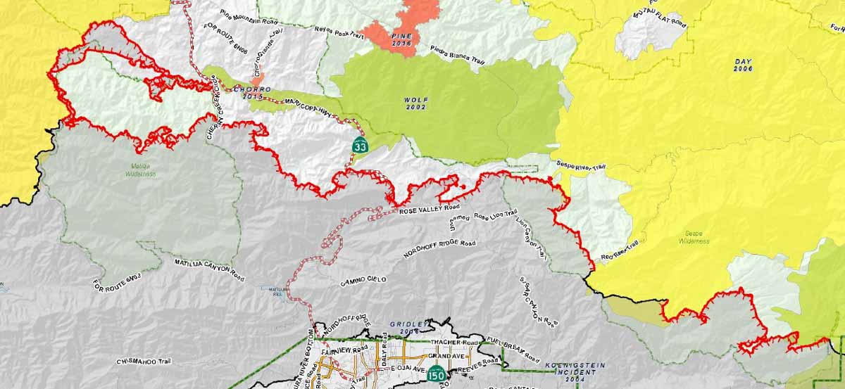
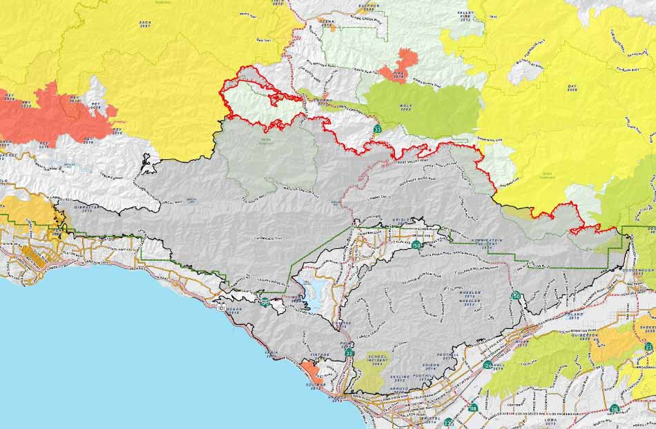
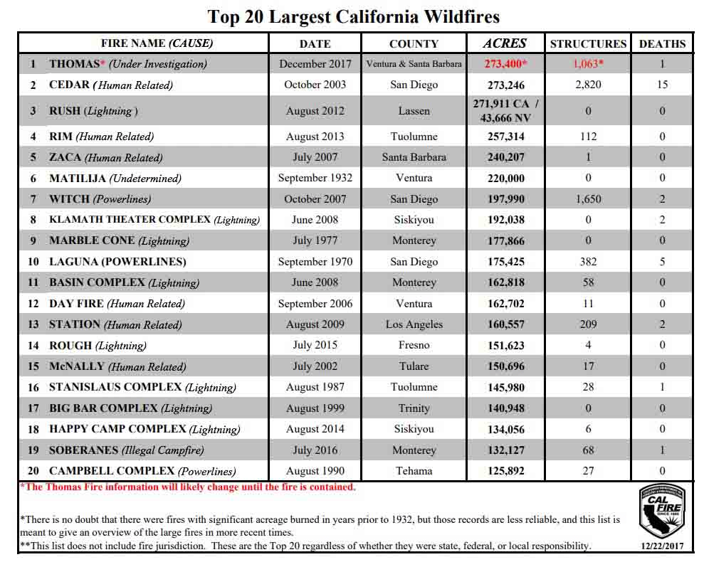
Many veteran firefighters in California have stories about spending Thanksgiving on wildfires. Fewer have experienced Christmas on a large fire. But today, on Christmas Eve, over 2,500 are working on the Thomas Fire that has become the largest in the recorded history of California — 273,400 acres so far. It started in December and is only 78 percent contained.

Map of the Thomas Fire, December 23, 2017
Map of the north side of the Thomas Fire, December 23, 2017. The red line represents uncontrolled fire edge. Credit: Incident Management Team. Click to enlarge.

The southern boundary of the fire from Santa Barbara to Ventura is contained and secure. Thanks to shorter days and a lack of strong winds the Incident Management Team does not expect any additional significant spread of the fire, other than strategic burning to secure the fire edge.

The planned 20,000-acre firing operation that would have removed fuel and secured approximately 17 miles on the north side apparently was halted by the weather, including a few snow flurries. That area is still shown as uncontrolled on the Team’s map. But on Saturday firefighters conducted firing operations on the northern flank along Cherry Creek Road near Highway 33 to keep the fire from moving to the north.

All articles on Wildfire Today about the Thomas Fire are tagged “Thomas Fire”.

Santa and Mrs. Claus firefighters Thomas Fire
Santa and Mrs. Claus visit with firefighters on the Thomas Fire on Christmas Eve. Photo credit: Ventura County Fire Department.

The blaze would have been much larger if it had not burned into previous fires, including the 2009 Jesusita, 2007 Zaca, and 2006 Day Fires. If the weather had not changed, the 2002 Wolf Fire would have assisted in controlling it on the north side near Highway 33.

Saturday at 6:00 p.m. responsibilities were transferred to California Interagency Incident Management Team 3 under the leadership of Incident Commander Mark Von Tillow. Most fire suppression activity is now on National Forest System lands.

There are currently no mandatory evacuation orders in effect. Residents on Highway 33 between Rose Valley north to Hartman Ranch remain under a voluntary evacuation warning due to fire activity in the nearby areas.

Map of the Thomas Fire, December 23, 2017
Map of the Thomas Fire, December 23, 2017, by the Incident Management Team. Click to enlarge.

10 largest California wildfires

Thomas Fire Christmas Eve
Thomas Fire, Christmas Eve. Credit: Los Padres National Forest.