Firefighters begin large firing operation on Thomas Fire

The backfire should take three to four days and could encompass at least 15,000 to 20,000 acres.

Above: The northernmost red perimeter area is the beginning of the firing operation that could cover 20,000 acres if successfully completed. Map by Incident Management Team.

(Originally published at 9:45 a.m. PST December 19, 2017)

On Monday firefighters on the 271,750-acre Thomas Fire in Southern California began a very large firing operation, or backfire, out ahead of the fire that will remove fuel and secure approximately 17 miles of the north side of the fire. It is one to three miles away from the current fire edge and will tie in with Highway 33. In the video below Operations Section Chief Brian Rhodes explains that it could continue east to Rose Valley.

All articles on Wildfire Today about the Thomas Fire are tagged “Thomas Fire”.

On Monday the fire was relatively quiet compared to activity during the previous 16 days, allowing firefighters to secure additional firelines. However the firing operation created a large smoke column on the north side. The threat to Fillmore has decreased with the completion of line from town to Devil’s Gate. Continued strengthening of control lines will help to further decrease threats. On the north and east flanks of the fire, the fire continues to progress further into the Matilija and Sespe Wilderness and toward the Sespe Condor Sanctuary. Fire suppression repair and damage inspection will continue as appropriate based on fire conditions. Repopulation will continue as threats in previously evacuated areas decreases.
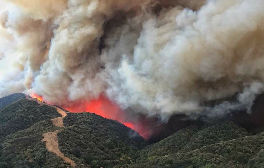
Thomas Fire
Thomas Fire. Photo credit: Ventura County Fire Department.

Steep, rugged terrain on the Thomas Fire along Hwy. 33.

Rob Lowe had some firefighters over for dinner during the Thomas Fire

Dinner for new friends at our house.

A post shared by Rob Lowe (@robloweofficial) on

Rob Lowe showed appreciation for firefighters that helped protect his home and many others in the Montecito area on the Thomas Fire in Southern California.

Thank you to all the crews from all over the country who stood tall and saved my town. #respect #gratitude

A post shared by Rob Lowe (@robloweofficial) on

Two firefighters injured on Thomas Fire

The fire is likely to become the largest California fire in recorded history

Above: An injured firefighter in Rose Valley near Ojai is carried to a waiting Ventura County Fire Department Helicopter on the Thomas Fire. Photo by Ventura County FD.

(Updated at 10:27 a.m. PST December 18, 2017)

Two firefighters were injured Sunday while battling the Thomas Fire in Southern California, authorities said. One of them was flown out of  Rose Valley near Ojai to a hospital. The injuries were minor but the helicopter was used due to the rough terrain.

No further information was available about the second firefighter, who reportedly also had minor injuries.

Cory D. Iverson, a CAL FIRE firefighter from San Diego County, was killed while working on the incident December 14. A firefighter from Redding, California suffered a broken leg December 10 on the same fire.

Injured firefighter Thomas Fire
An injured firefighter in Rose Valley near Ojai is carried to a waiting Ventura County Fire Department Helicopter on the Thomas Fire. Photo by Ventura County FD.

A very large burnout operation is planned on the north side of the fire in the Sespe wilderness that will add 15,000 to 20,000 acres to the fire. Depending on cooperation of the weather, it will take three to four days to complete the project using aerial and ground ignition.

An unheard of number of firefighters are assigned to the blaze – 8,452. When there were over 5,000 working on the Rim Fire that burned into Yosemite National Park in 2013 we thought that was a huge number.

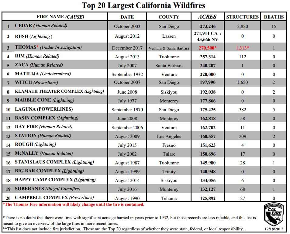
The fire has burned 270,500 acres in Ventura and Santa Barbara Counties since it started December 4. At this size it  is the third largest in the recorded history of California, only about 3,000 less than the 273,246-acre Cedar Fire that burned into the suburbs of San Diego in 2003 destroying 2,820 structures and killing 15 people.

largest fires in California

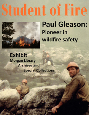
University exhibit recognizes contributions of Paul Gleason

The exhibit will be at Colorado State University through January 31, 2018

Paul Gleason
Paul Gleason. From Wildland Fire Leadership.

Colorado State University is hosting an exhibit featuring a wildland firefighter who made significant contributions to our culture of safety and leadership. Even though he retired in 2001 and succumbed to cancer two years later his name and legacy live on through the annual Paul Gleason Lead by Example Award and “LCES”. After his experience on the 1990 Dude Fire  he developed the easy to remember concept of “Lookouts, Communications, Escape Routes, and Safety Zones (LCES)” which he distilled from the 10 Standard Firefighting Orders. He as also the first person I knew to use the phrase “student of fire”.

The “Student of Fire” exhibit will be at the Colorado State University’s Morgan Library, room 202, through January 31, 2018, at 1201 Central Avenue Mall, Fort Collins, Colorado. (map)

The article below about Paul and the exhibit was written by Linda Meyer for the University.


Exhibit recognizes contributions of Paul Gleason, wildfire safety pioneer

Morgan Library Archives and Special Collections is featuring an exhibit showcasing the contributions of Paul Gleason to the field of wildland fire science through Jan. 31.

Gleason contributed significant training materials to the field, especially on the topic of firefighter safety. After retiring from a career as a wildland firefighter, leader, and strategist he became a faculty member at Colorado State University in the Department of Forestry and Natural Resources, where a scholarship has been established in his name.

Karen Miranda Gleason donated her late husband’s papers, photographs and documents detailing events such as the Crosier Mountain prescribed fire west of Fort Collins, to Morgan Library. The collection also features Gleason’s 1991 paper, “Lookouts, Communication, Escape Routes, Safety Zones,” commonly referred to as “LCES” or “the LCES concept,” which has become the foundation of current wildland firefighter safety.

Pioneer in wildfire safety
Born in 1946 in Chicago, Illinois, to a homemaker from Seattle and a Baptist minister from Tacoma, Washington, Gleason grew up in Southern California. Becoming an accomplished rock climber in his teens, he continued to enjoy climbing throughout his life. Correspondence between Gleason and his father often refers to his love of the outdoors and mountaineering.

Gleason’s career as a firefighter began in 1964 in the Angeles National Forest as an 18-year-old member of the Dalton Hotshot Crew. He served with that crew through 1970, interrupted only by a one-year tour of duty with the U.S. Army. From 1971 to 1973, he attended Colorado State University and earned a degree in mathematics.

In 1974, Gleason returned to work as a firefighter, serving as the assistant foreman for a Regional Reinforcement Crew on the Okanogan National Forest. In 1977, he became the assistant superintendent of the ZigZag Hotshot Crew at Mount Hood National Forest, moving into the position of superintendent two years later.

Paul Gleason exhibitGleason began work as a district fire management officer for the Arapaho-Roosevelt National Forest in 1992, eventually becoming the forest fire ecologist. In 1999, he moved to the position of deputy fire management officer for the Rocky Mountain Region of the National Park Service. Mandatory retirement  in 2001 sent Gleason into academia at age 55. He served as an adjunct professor for the Wildland Fire Science program at Colorado State University for two years before losing his battle with cancer in 2003.

Gleason received numerous awards and recognitions throughout his career. He was heavily involved in three significant fires: the Loop Fire in 1966, the Dude Fire in 1990, and the Cerro Grande Fire in 2000.

Firefighters on Thomas Fire save hundreds of homes in Montecito area

Updated total of homes and commercial structures destroyed: 1,558

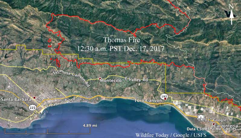
Above: 3-D map of the west end of the Thomas Fire in the Santa Barbara and Montecito area showing the perimeter at 12:30 a.m. PST December 17, 2017.

(UPDATED at 1:46 a.m. PST December 17, 2017)

Firefighters on the 269,000-acre Thomas Fire in Southern California have had good days and bad days since it started December 4, but in an epic battle Saturday they saved hundreds of homes in the Montecito area east of Santa Barbara. The Ventura County Fire Department Public Information Officer referred to it as a “BIG firefight to hold their line”.

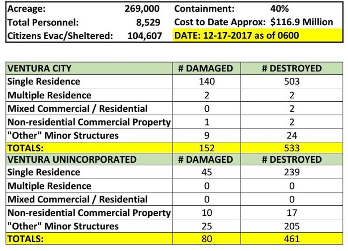
The Incident Management Team announced Sunday that the updated total of homes and commercial structures destroyed is 1,558.

The west end of the Thomas Fire is burning on the mountain slopes in the Los Padres National Forest above Santa Barbara and Montecito but it has worked its way out of the Forest to the periphery of Montecito.

Map of the Thomas Fire
Map of the west side of the Thomas Fire. The red line was the perimeter at 12:30 a.m. PST December 17, 2017. The white line was the perimeter on December 10. Click to enlarge.

The huge blaze is now the third largest in the recorded history of California.

The winds on the west end of the fire Sunday will be out of the southwest or northwest and relatively light, but the east side could experience strong Santa Ana wind conditions — northeast winds of 25 to 40 mph with gusts to 60 mph while humidities will lower to 10 to 15 percent. The entire area is under a Red Flag Warning.

map Thomas Fire december 17 2017
Map of the Thomas Fire. The red line was the perimeter at 12:30 a.m. PST December 17, 2017. The white line was the perimeter on December 10. Click to enlarge.

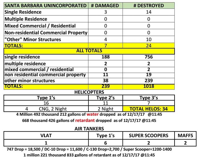
Here are the latest stats from the Incident Management Team”

statistics Thomas Fire California

statistics Thomas Fire California

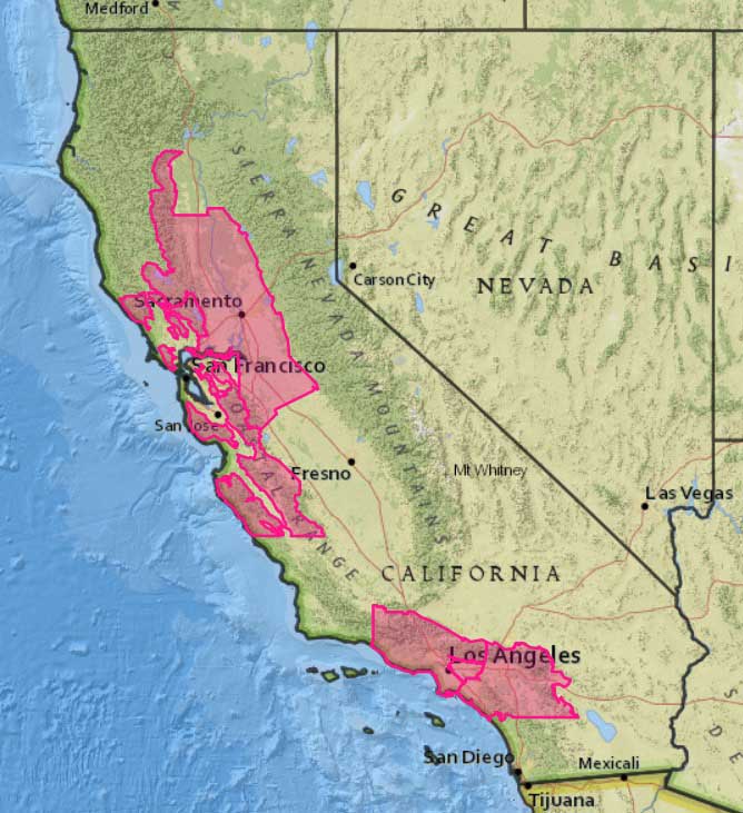
Red Flag Warnings for California

Red Flag Warning December 17 2017 CaliforniaRed Flag Warnings have been issued for portions of California today. In Los Angeles and Ventura Counties northeast winds of 25 to 40 mph with gusts to 60 mph will continue into the afternoon while humidities will lower to 10 to 15 percent today.

The map was current as of 10:36 a.m. MST on Sunday. Red Flag Warnings can change throughout the day as the National Weather Service offices around the country update and revise their forecasts.