Lilac Fire spreads from Interstate 15 to Bonsall, destroying 65 structures

The fire ran for six miles along Highway 76 Thursday afternoon in Southern California.

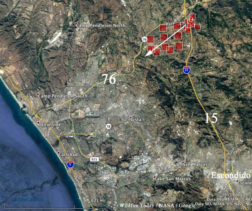
Above: Map of the Lilac Fire at 12:01 a.m. PST December 8, 2017.

(UPDATED at 5:12 a.m. PST December 9, 2017)

There were no significant changes in the perimeter of the Lilac Fire on December 8. Firefighters were able to make progress on containment lines due to favorable weather conditions.

CAL FIRE and Cal OES damage assessment teams have started their inspections. At last count 105 structures were destroyed. Friday morning CAL FIRE Incident Management Team 1 assumed command. The team is in unified command with Oceanside Fire Department, Vista Fire Department, North County Fire Protection District and the San Diego County Sheriff Department.

The official size, according to CAL FIRE, is 4,100 acres.

****

(UPDATED at 5:47 p.m. PST December 8, 2017)

****

(Originally published at 8:51 a.m. PST December 8, 2017)

Fire officials said 65 structures have been destroyed in the 4,100-acre Lilac Fire southwest of Temecula, California. After it started at 11:15 a.m. Thursday at Interstate 15 near the intersection of Highway 76 it was pushed along the Highway 76 corridor by strong Santa Ana winds. By midnight it had spread for 6 miles to the southwest  almost enveloping the community of Bonsall.

(All articles on Wildfire Today about the Lilac Fire can be found HERE.)

Many of the destroyed structures were in a mobile home park southwest of the I. 15/Hwy. 76 intersection.
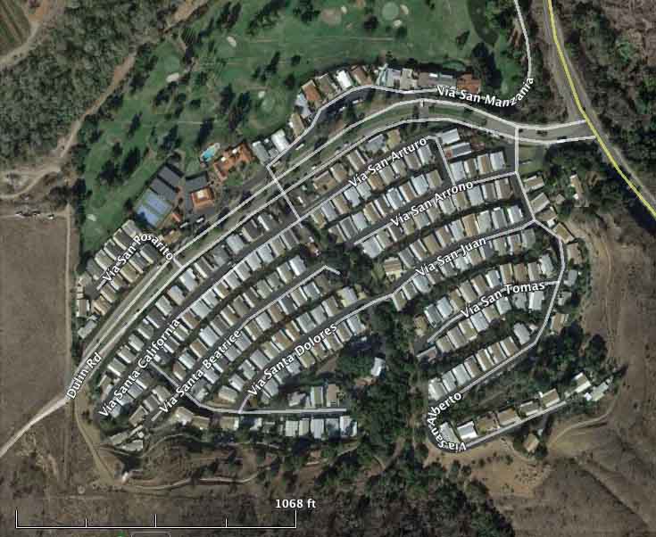
mobile home park
File photo of the mobile home park before the fire.

The video below, recorded Thursday evening, shows the fire within the mobile home park.

Three civilians suffered burn injuries before they were able to evacuate from the rapidly spreading fire. Two firefighters were also injured, but not from burns.

Many areas are still under mandatory evacuation orders.

Firefighters are using military helicopters from Camp Pendleton and Naval Air Station North Island during the day and night flying helicopters from San Diego Fire-Rescue at night.

NBC7 in San Diego reported that several hundred race horses at the San Luis Rey Downs training facility east of Bonsall were turned loose to fend for themselves since there was not enough time to load all of them into trucks or trailers and transport them to safety. Not all of them survived.

Lilac Fire — a new fire in San Diego County

Above: The view of the Lilac Fire as seen from an HPWREN camera on Red Mountain near Fallbrook, CA, looking south at about 1:45 p.m. PST December 7, 2017.

(UPDATED at 4:25 p.m. PST December 7, 2017)

CAl FIRE reports that the Lilac Fire south of Temecula, CA has grown to 2,500 acres. New evacuation order: South of Hwy 76, West of I-15 Freeway, North of Gopher Canyon Rd, East of East Vista Way & Mission Rd.

Two civilian burn victims were treated & transported.

(All articles on Wildfire Today about the Lilac Fire can be found HERE.)

A temporary evacuation point has been set up at the Carlsbad Forum, and a temporary evacuation center has been established at Great Oak High School, 32555 Deer Hollow Way, Temecula, CA.

Approximately 20 structures have been destroyed.

map lilac fire california wildfire
The red squares represent heat detected by a satellite on the Lilac Fire early in the afternoon on December 7, 2017. Click to enlarge.

****

(UPDATED at 2:40 p.m. PST December 7, 2017)

The Lilac Fire south of Temecula, CA “is growing at a dangerous rate of spread with 1,000 structures threatened”, a spokesperson for CAL FIRE said at 2:25 p.m. Five structures have been destroyed and Highway 76 is closed in both directions.

In addition to federal and state aircraft working the fire now, CAL FIRE is making arrangements to use military helicopters from Camp Pendleton and Naval Air Station North Island during the day and night flying helicopters from San Diego Fire-Rescue.

Continue reading “Lilac Fire — a new fire in San Diego County”

Thomas Fire almost surrounds Ojai, California

Wednesday night the fire spread further up the coast toward Carpinteria

(UPDATED at 8:24 p.m. PST December 7, 2017)

The northeast and northwest sides of the Thomas Fire continued to be very active again on Thursday. Fire authorities said 427 structures in Ventura have been destroyed and at least 85 more were damaged. Approximately 12 were destroyed in unincorporated areas of Ventura County. Ojai is becoming even more boxed in by the fire, but so far that community and Carpinteria, where the blaze is knocking on the southern boundary of the city, have avoided any large losses in the fire.

(All articles about the Thomas Fire on Wildfire Today are tagged “Thomas Fire”.)

The additional area burned Thursday brings the total number of acres up to approximately 129,000 according to our estimates. At 6:30 p.m. CAL FIRE was calling it 115,000 acres.

Until the strong Santa Ana winds subside, there is not a lot that firefighters can do to stop major spread of the fire.

map thomas fire
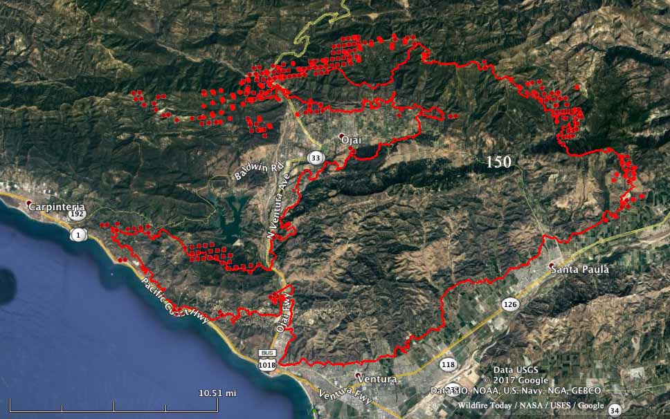
The red line on the map of the Thomas Fire was the perimeter at 10 p.m. PST December 6, 2017. The red dots represent heat detected by a satellite in the 12-hour period ending at 8 p.m. PST December 7, 2017. Click to enlarge.

****

(UPDATED at 1:15 p.m. PST December 7, 2017 to include a better map below)

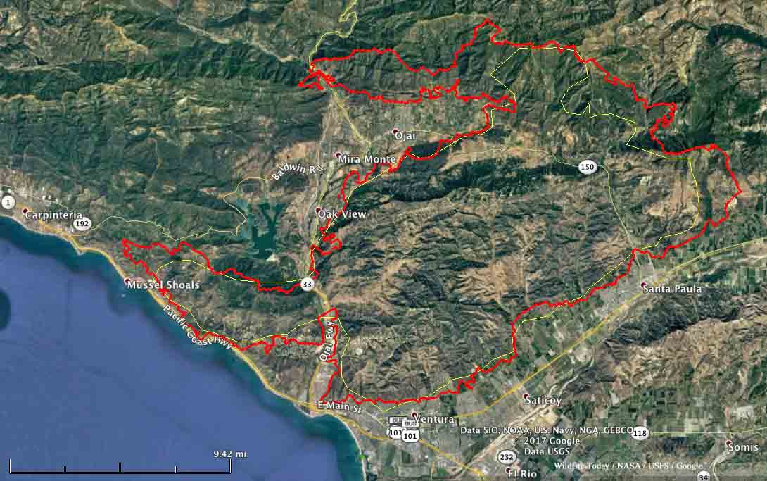
Strong winds Wednesday night from the east and northeast continued to push the Thomas Fire further to the west and north. It spread along the coast toward Carpinteria and as of 2 a.m. Thursday was about a mile south of Highway 150 where the road enters the city.

The fire also moved around Ojai on the north side, blazing a new path to the west two miles wide by eight miles long and crossing, again, Highway 33 northwest of the city. Ojai is now surrounded on three sides by the Thomas Fire.

Click on the map below to see a larger version.

map Thomas fire December 6 2017
The red line was the perimeter of the Thomas Fire at 10 p.m. PST December 6, 2017. The yellow line was the approximate perimeter at 1 a.m. PST December 5. Click to enlarge.

The Ventura County Fire Department is calling it 96,000 acres, but we think it was least 112,000 acres when the data for the map above was collected at 10 p.m. December 6. The unofficial threshold for a fire to obtain “megafire” status is 100,000 acres… so, it qualifies.

Wednesday night a weather station at Oxnard recorded east and northeast winds of 12 to 27 mph gusting up to 32 mph.

Evacuations have been ordered for areas near Carpinteria and Ojai.

red flag weather
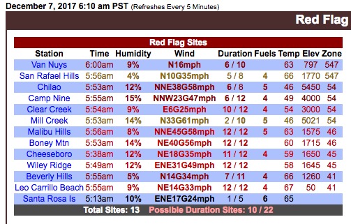
Weather stations in the Los Angeles area that meet the Red Flag Warning criteria at 6:10 a.m. PST December 7, 2017.

Articles on Wildfire Today about this fire are tagged Thomas Fire.

Ludicrous Fire Weather predicted in Southern California through Saturday

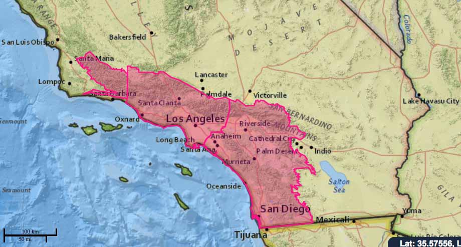
Above: the Red Flag Warning forecast through Friday for Alpine, California, east of San Diego.

(Originally published at 5:36 p.m. PST December 6, 2017)

In wildland fire we sometimes talk about “extreme fire weather”… strong winds with low relative humidity. But, the conditions in the forecast for Southern California Wednesday night through Saturday require a new description — Super Extreme, or Very Extreme, or, borrowing a term from Tesla vehicles, “Ludicrous” Weather?

Red Flag Warnings are posted through Saturday, with some of the strongest winds predicted for San Diego County which Wednesday night and Thursday could experience northeast winds of 25 to 35 mph, with gusts to 60 and isolated gusts to 90 mph. Oh, and relative humidity even at night will be in the low teens or single digits.

Wednesday night Ventura and Los Angeles County residents should expect northeast winds of 30 to 50 mph with gusts of 65 to 80 mph. Thursday through Saturday the winds will decrease slightly, 20 to 35 with gusts of 45 to 60 mph.

This is a very serious situation developing in Southern California — years of drought and several days of dry Santa Ana winds followed by Ludicrous Weather with winds gusting throughout the area at 80 to 90 mph. This of course could have a major effect on the existing fires. All it takes is one very small ember to be blown into receptive fuels and … well, perish the thought.

And there’s no doubt that new fires will break out. Wildland firefighting resources are stretched thin covering the 80,000 acres already on fire. It will be difficult to find hundreds or thousands of additional firefighters and large numbers of hand crews and engines if the worst case scenario develops. And the stronger the winds are, the less effective aerial resources can be. Those conditions can make it unsafe to fly low and slow over rough terrain, as they have to do, and the wind can blow the retardant or water far off target.

Ludicrous Fire Weather begins tonight!

30 homes reported destroyed in the Creek Fire

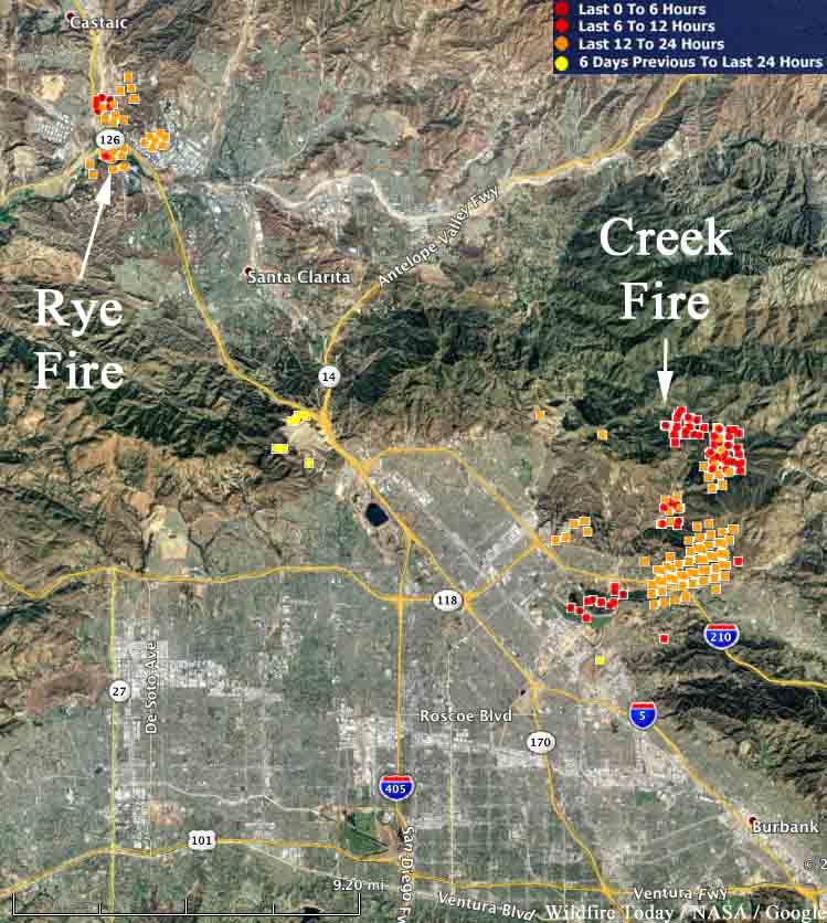
The Creek Fire has burned 11,337 acres in Los Angeles. The nearby Rye Fire in Santa Clarita was mapped at 7,000 acres.

map creek fire rye fire
Map showing heat detected by a satellite on the Creek and Rye Fires in the Los Angeles Area. The red dots are the most recent, detected at 12:40 a.m. PST December 6, 2017. It is likely that some areas with light vegetation burned and then cooled before the heat sensors on the satellite detected them on the subsequent pass, and therefore do not show up.

The Creek Fire on both sides of the 210 freeway in Los Angeles has burned 11,377 acres and destroyed 30 homes. Three firefighters have been injured and 30 horses were killed.

Both sides of the 210 freeway near Sylmar that had been closed, reopened Wednesday morning. The fire started early Tuesday morning in the Kagel Canyon area.

Another fire in the same general area has burned 7,000 acres. The Rye Fire was reported Tuesday morning in Santa Clarita near Castaic Junction, the intersection of Interstate 5 and Highway 126. Officials are considering lifting some of the mandatory evacuation orders. About 775 firefighters are on scene.

The 405 opens after being closed by the Skirball Fire in Los Angeles

map skirball fire
Map showing the location of the Skirball Fire that started early Wednesday morning in Los Angeles. Click to enlarge.

(UPDATED at 4:40 p.m. PST December 6, 2017)

The 405 freeway has reopened after being closed by the Skirball fire across the freeway from the Getty Center. Los Angeles Fire Department reported Wednesday afternoon that the fire has burned 475 acres and damaged at least eleven homes and destroyed four. Fire officials said 700 homes were evacuated near the Sepulveda Pass.

Skirball Fire map los angeles
The red line on the 3-D map represents the approximate location of the Skirball fire as detected by heat sensors on a satellite at 12:01 p.m. PST December 6, 2017. Later the fire doubled in size. Click to enlarge.

****

(Originally published at 8 a.m. PST December 6, 2017.)

A wildfire that started early Wednesday morning near the Getty Center and Sepulveda Pass has forced the closure of all lanes of the 405 freeway in Los Angeles, one of the busiest highways in the state.

The Skirball fire was reported at 4:50 a.m. and was more than an acre when the first units arrived. Live video from Los Angeles television stations have shown at least two homes with flames on the roofs near Casiano Road. Mandatory evacuations are in effect for the area.

North winds of 8 to 14 mph and a relative humidity in the low 20’s caused the fire to spread rapidly to the south.

At about 7 a.m. the reported size of the fire was 50 acres, but it may have grown significantly since then. Helicopters, scooping air tankers, and about 220 firefighters were working the fire Wednesday morning.