Another community evacuated near Sunrise Fire in western Montana

Above: 3-D map of the Sunrise Fire looking west. The red line was the perimeter at 9 p.m. MDT July 30, 2017. The white line was the perimeter two days earlier.

(Originally published at 5:55 p.m. July 31, 2017.)

During the last two days the Sunrise Fire west of Missoula, Montana 6 miles south of Riverbend has continued to work its way down the slopes near the small communities west of the Clark Fork River, moving to within 1.5 to 0.3 miles of the river. As of Sunday night it had burned about 8,200 acres, an increase of 2,700 acres in the last two days.

Another community, Verde Creek, has been added to the evacuation orders that already included Sunrise, Quartz Flats, and Quartz Creek.

The areas of major growth on Saturday and Sunday were on the north and southeast sides.
Sunrise Fire
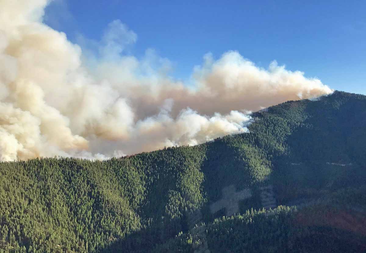
The Sunrise Fire, July 30, 2017. Photo by Kevin Chaffe.

On the south side, the fire continued to burn into the Quartz Creek drainage; retardant was used to slow its spread downslope. On the north side in Sunrise Creek, the fire made an aggressive uphill run towards Eagle Rock and Verde Saddles.

Hotshot crews conducted controlled burning operations to reduce fuels in the Sunrise and Quartz Flats Communities while helicopters and air tankers were busy on all areas of the fire.

Resources assigned include 14 hand crews, 6 helicopters, 31 engines, 5 dozers, 14 water tenders, 4 skidgens, and 1 masticator for a total of 494 personnel.

All articles about the Sunrise Fire can be found HERE, with the most recent at the top of the page.

Wildfires in Modoc County, California add another 11,000 acres

The Modoc July Complex of fires in northeast California has now covered 50,916 acres.

Above: Cove Fire, July 29, 2017. Uncredited photo on Inciweb.

(Originally published at 11:28 a.m. PDT July 31, 2017)

Two of the wildfires in the Modoc July Complex of fires in northeast California were very active Sunday, adding a combined 11,293 acres to bring the total burned area to 50,916 acres.

The Type 2 Incident Management Team transitioned to a Type 1 Team Monday morning, so we are in the usual dead zone for up to date fire information — yesterday was a time when the previous team does not want to step on the toes of the incoming team and today the new team is still getting their feet on the ground. This transition period can also be a time of heightened danger for firefighters out on the fire.

But the new team provided some additional information after 11 a.m. today, Monday.

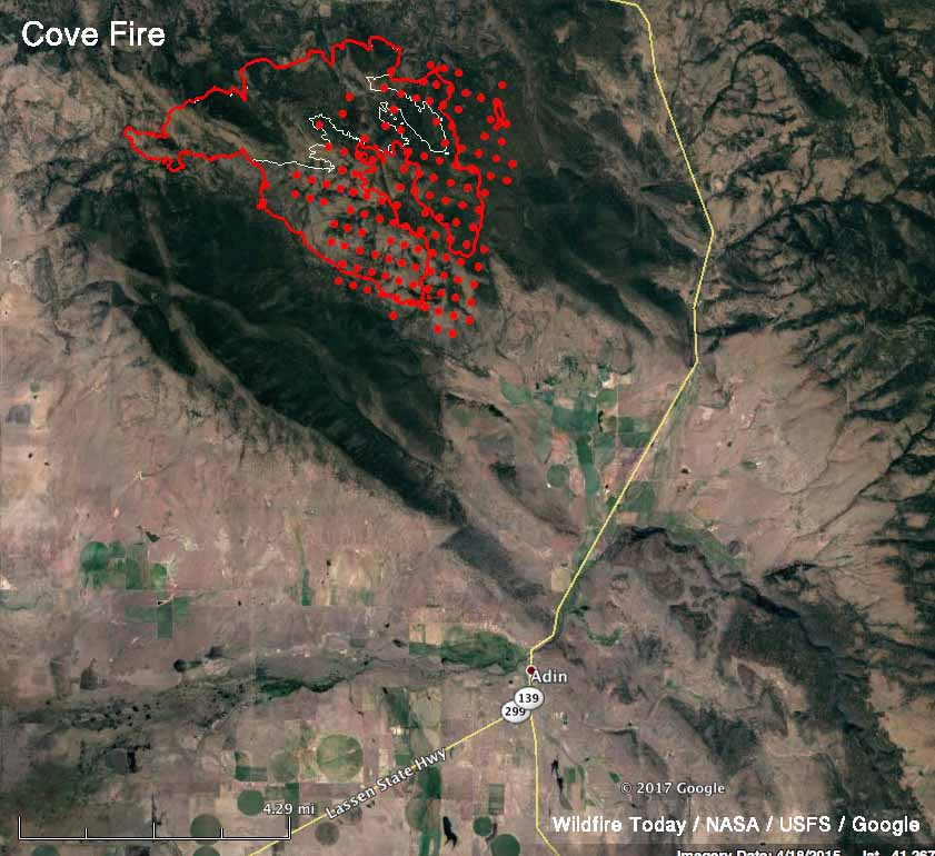
map cove fire
Map of the Cove Fire in Modoc County, California. The red line was the perimeter at 11:30 p.m. PDT July 30. The white line was the perimeter 24 hours before. The red dots represent heat detected by a satellite at 3:19 a.m. PDT July 31, 2017.

But we do know, thanks to overflights of the fires by a satellite and fixed wing aircraft, that the Cove Fire spread aggressively to the east and southeast. It is now about five miles northwest of Adin, a town that had 272 residents in the 2010 census.

Conditions Sunday along the southern edge permitted tactical firing operations from the 40N14 Road to the 40N09 Road to aid in securing the southern edge of the fire. Firefighters also conducted firing operations from the 40N14 Road to the 40N12 Road to strengthen firelines. The northern fireline held overnight with no additional fire spread.

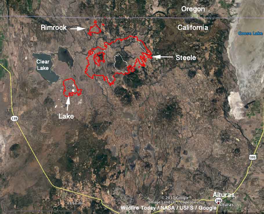
Modoc July Complex of fires california
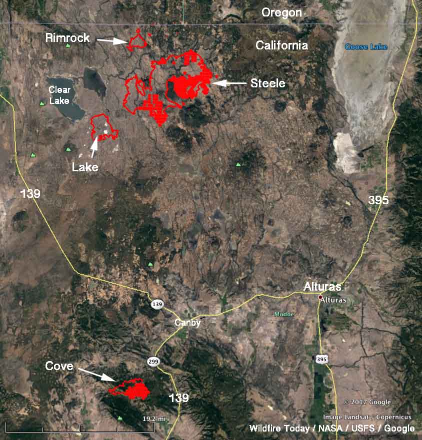
Map of the fires in the north portion of the Modoc July Complex of fires in Modoc County, California. The red line was the perimeter at 11:30 p.m. PDT July 30. The white line was the perimeter 24 hours before.

The other active fire in the Complex was the Steele Fire which also grew on the southeast side but did not spread as much as the Cove Fire farther south. Northeast winds pushed the fire across the 136 Road to the south in an additional location. Crews and dozers contained the 40-acre slopover and by Monday morning had mopped up 50 feet inside the line.

There has been very little growth on the Lake and Rimrock fires.

The weather forecast for Monday through Thursday for Canby, north of the Cove Fire, calls for temperatures around 100 with relative humidities about 10 percent. The wind, at 2 to 6 mph, will be from variable directions during the period. An Excessive Heat Warning is in effect for Tuesday through Thursday.

All of the articles about the Modoc July Complex of fires can be found here, with the most recent at the top. 

Sky lantern sets fire to Olympic venue in Rio

The track and roof of the velodrome used in the 2016 Olympics in Rio de Janeiro were damaged after a sky lantern landed on the facility. Much of the roof was heavily damaged and photos from TV network Globo showed a 20 to 30 meter section of the track had burned. Wood from Siberia was used to construct the track surface which made it one of the last venues in the Rio Olympics to be ready.

Sky lanterns, also known as Chinese lanterns, are plastic or paper bags lofted by the heat created by burning fuel at the bottom. After they are launched the perpetrator has no control and the dangerous devices are carried wherever the wind blows. Too often they get caught on trees, roofs, cell phone towers, or land on the ground when the flames are still active and start damaging fires. They are banned in most U.S. states and many countries, including Brazil.

Some areas enact specific laws or regulations prohibiting sky lanterns, but they are banned in any state or city that adopts the 2015 edition of the International Fire Code.

Thanks and a tip of the hat go out to Andrew.
Typos or errors, report them HERE.

Excessive Heat Warnings and Watches starting Monday on west Coast

(Updated at 8 a.m. MDT July 31, 2017)

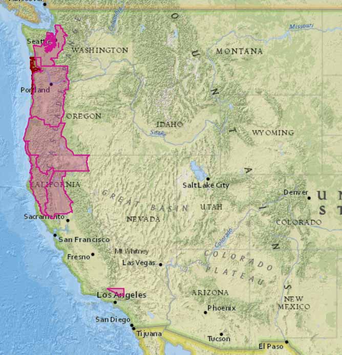
excessive heat warning
The red areas indicate warnings for excessive heat through Thursday August 3 with temperatures at various times reaching into the triple digits — even in the Seattle area on Thursday.

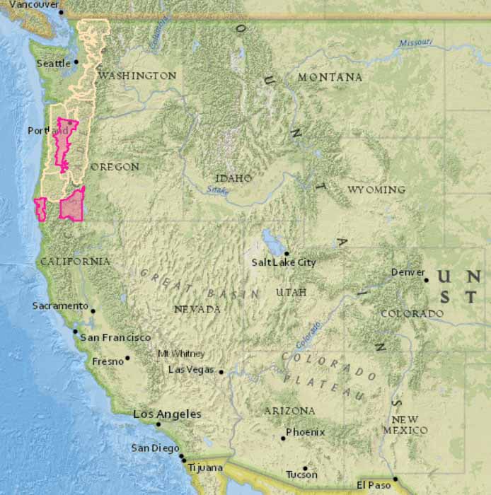
Above: excessive heat warnings. Below: Red Flag Warnings and Fire Weather Watches. All were updated at 7:50 a.m. MDT July 31, 2017.

wildfire danger red flag warning
The red areas are under a Red Flag Warning on Monday. The yellow areas indicate Fire Weather Watches for elevated wildfire danger for the next several days.

Firefighters: be careful out there. It’s a good time to review how to prevent and deal with heat related illnesses. Drinking water is important, but it will not prevent heat exhaustion, heat stroke, or rhabdo. And those last two can kill.

France will be ordering Q400’s to replace their S-2 air tankers

Above: Bombardier Q400MR — Bombardier Photo.

This article first appeared on Fire Aviation.

(Originally published at 3:52 p.m. MDT July 29, 2017.)

France’s Securite Civile (Department of Civil Defence and Emergency Preparedness) is replacing their ageing turbine-powered S-2 air tankers with Bombardier Q400-MR’s. The bids for the contract were advertised in 2016 and this week Gérard Collomb, Minister of the Interior, announced that they will place an order for six of the Multi-role aircraft that can carry up to 2,600 US gallons of water or retardant.

For several years Securite Civile has been pondering what to do about replacing their S-2’s that are approaching their structural life limit of 25,000 hours, according to the agency. Their plans announced last year were to retire the nine S-2’s between 2018 and 2022 which would require a two-year extension of the type certificate. The goal was to acquire aircraft that could carry more water or retardant, would reduce operating costs, and would be multi-role. The Q400 MR (the MR stands for “Multi-Role) can haul cargo or passengers in addition to operating in the firefighting realm.

Q400MR Bombardier
Bombardier Q400MR dropping retardant. Bombardier photo.

France considered the CL-415 water-scooping amphibious tanker formerly made by Bombardier, but it is no longer in production with the program being sold to Viking Air Limited in 2016. Viking is considering manufacturing them again, but for now they are providing service and support for the CL-215’s and CL-415’s operating around the world.

Securite Civile has operated two Q-400 air tankers since 2005, so retiring the S-2’s and acquiring more Q-400’s will reduce the complexity of the maintenance and operation of their fleet.

In addition to the 9 S-2’s and 2 Q-400’s, France also has 11 or 12 CL-415’s and 40 helicopters.

Thanks and a tip of the hat go out to Isaac.
Typos or errors, report them HERE.

Fires in Modoc County, California grow by almost 20,000 acres

Combined, the fires have burned 39,623 acres.

Above: Fire engines on the Cove Fire, part of the Modoc July Complex of fires in northeast California: ANF E31 and ENF E364. Uncredited/undated photo on Inciweb.

(Originally published at 9:08 a.m. PDT July 30, 2017)

The Complex of lightning-caused wildfires in Modoc County in northeast California grew by almost 20,000 acres on Saturday, bringing the total to 39,623 acres.

Most of the fires are west of Highway 395 and east of Highway 139, but the Cove Fire that had burned approximately 3,500 acres as of 2 a.m. Sunday is south and west of highway 139, nine miles southwest of Canby. It was extremely active Saturday night advancing to the southeast. Firefighters are working to create a fireline by utilizing the existing Forest Service Road 40N14.

The map below shows the locations of the fires in Modoc County, California.

map Modoc July Complex fires California
Map of the Modoc July Complex of fires in northeast California. The red lines were the perimeters at 10:30 p.m. PT July 29, 2017. The red dots represent heat detected by a satellite at 2 a.m. PDT July 30, 2017. Click to enlarge.

One of the fires in the Complex, the Steele Fire east of Clear Lake, is currently 29,779 acres. On Saturday it crossed County Road 136 to the south, but crews and dozers were able to put a line around 75 percent of the slopover.

On Monday NorCal Incident Management Team 2 will turn over command of the fire to a Type 1 organization, the California Interagency Incident Management Team 4.

Modoc July Complex fires California
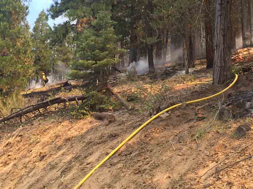
A hose lay on the Cove Fire. Uncredited/undated photo on Inciweb.

All of the articles about the Modoc July Complex of fires can be found here, with the most recent at the top.