California firefighter dies after suffering chain saw injury

Frank Anaya
Frank Anaya

A California firefighter died July 11 in a hospital from injuries he suffered July 5 while fighting a wildfire near Lakeside in Southern California.

Frank Anaya, an inmate firefighter with the California Department of Corrections and Rehabilitation based at the La Cima Conservation Camp, was throwing cut brush during line construction operations when he lost his balance and fell into a running chainsaw. He suffered a severe cut to his upper right leg behind his chaps.

The 22-year old firefighter underwent multiple surgeries, but succumbed to his injuries July 11, 2017, according to the CDCR.

Our sincere condolences go out to Mr. Anaya’s friends, family, and coworkers.

Other California inmate firefighter fatalities that we are aware of in the last six years:

  • January 4, 2012. Crisanto Leo Lionell. Heart attack near the conclusion of a 20-minute, .66 mile exercise hike.
  • August 19, 2012. Jimmy Randolph. Anoxic encephalopathy combined with complications of heat stroke while assigned to the Buck Fire.
  • February 25, 2016. Shawna Lynn Jones. Struck by rolling boulder while working on the Mulholland Fire  .
  • May 24, 2017. Matthew Beck. Struck by falling tree while doing project work with his crew.

Edited July 14, 2017 to reflect new information in the Green Sheet. The victim was not running the chainsaw, but was swamping for it (throwing the cut brush).

Fires in Sicily and on Italian mainland — tourists evacuated by boat, slopes of Mt. Vesuvius burn

Posted on Categories UncategorizedTags ,

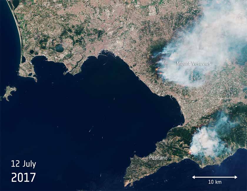
Above: Satellite photo from July 12, 2017 showing smoke from fires burning near Mount Vesuvius in Italy. The red dots represent heat from the fires. NASA.

(Originally published at 11:40 a.m. MDT July 13, 2017)

Two fires in Italy, one on the mainland and another on the island of Sicily, are in the news today.

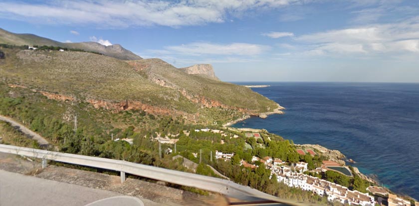
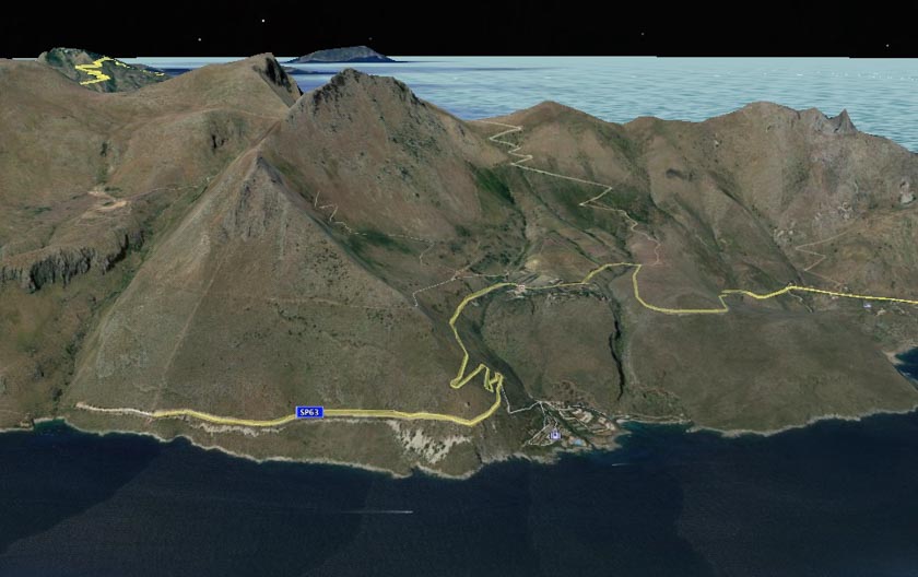
The fire on Sicily came very close to the Calampiso Resort 15 air miles northwest of Trapani and had authorities worried that tourists would be endangered by the fire directly, or trapped at the end of the dead end road leading to the community.

The Italian paper La Stampa quoted one evacuated tourist, Stella Belliotti, as saying: “We fled in swimwear and slippers. Our apartment was engulfed in flames. They were right above us. I took my daughter and I went to the beach. They made us go on the boats that go around Zingaro. First women and children, and then the others.”

Various reports say that 700 to 1,000 tourists were evacuated by boat from the Calampiso Resort and taken to San Vito Lo Capo 5 miles by boat to the northwest where the mayor, Matteo Rizzo, appealed on Facebook for residents to pick up the evacuees:

We need minibuses and cars to pick people up at the little port and take them to school buildings. Let’s all do something.

There were no reports of injuries.

Calampiso Resort
File photo of the Calampiso Resort area as seen from the access road. Google Street View.
3-D map Calampiso Resort Sicily
A 3-D view of the Calampiso Resort area on the northern end of Sicily. Google Earth.

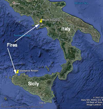
Numerous wildfires have been burning on the mainland of Italy on the slopes of Mount Vesuvius and nearby the volcano. The huge plume of smoke led some to believe that Vesuvius was erupting again. The last time it erupted was in 1944, but it is most famous for the 79 AD eruption that destroyed Pompeii.

map fires Mount Vesuvius Sicily
Vicinity map of southern Italy and the island of Sicily. Google Earth.
wildfires Mount Vesuvius
July 12, 2017 satellite image of wildfires at Mount Vesuvius. Copernicus Sentinel data, processed by ESA.


Alamo Fire near Santa Maria — no major changes Tuesday

(Originally published at 8:24 a.m. PDT July 12, 2017)

There have been no major changes in the status of the Alamo Fire east of Santa Maria, California in the last couple of days. The Incident Management Team fine tunes the mapped perimeter every day, mostly to make it more accurate.

Satellites have not detected any large heat sources during the previous 24 hours. This does not mean the fire is out; just that what is still burning can’t be detected by the sensors flying 200 miles overhead. A fixed wing mapping aircraft with infrared equipment flying much lower at 2 a.m. Wednesday found dozens of scattered hot spots, mostly in the northeast and south areas.

The fire is very large, 28,687 acres, and it will take some time to complete a fire line around the entire perimeter and mop up far enough inside to ensure it will be under control.

A mandatory evacuation order is still in effect for Tepusquet Canyon. Highway 166 is closed from Highway 101 to new Cuyama, and Tepusquet Canyon Road is closed from Highway 166 to Santa Maria Mesa Road.

The map of the Alamo Fire we posted Tuesday is still valid.

All articles we have written about the fire are tagged “Alamo Fire” and can be found here, with the most recent at the top.

Firefighters making progress on Whittier Fire, but it was very active on west side Tuesday

Above: A 3-D map of the Whittier Fire looking southeast. The data was updated at 7:30 p.m. PDT July 11, 2017. The areas shaded in light red were burning very actively when the fire was mapped.

(Originally published at 7:52 a.m. PDT July 1, 2017) 

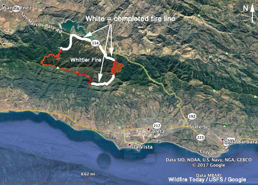
Firefighters have completed a containment line around almost half of the Whittier Fire northwest of Goleta, California, but it was still very active in some areas Tuesday. On the east side it spread into Hot Springs Canyon putting up a large plume of smoke that got the attention of residents in Goleta and Santa Barbara. But as of 7:30 p.m. on Tuesday the east side was still about half a mile away from San Marcos Pass Road which has served as a barrier on the north side.

By 7:30 p.m. Tuesday it had burned 11,920 acres.

map Whittier Fire
Map of the Whittier Fire updated at 7:30 p.m. PDT July 11, 2017. The areas shaded in red were burning very actively when the fire was mapped. Click to enlarge.

A containment line is complete on the northwest side from San Marcos Pass Road up to the rock quarry, but beyond that, going up the slope, the terrain is much more steep and complex. Firefighters are scouting that area up to the ridge, hoping to find a route for a line.

Wednesday morning a deeper marine layer put a damper on fire activity. Later in the day the forecast for the north side of the fire calls for mostly sunny skies, 88 degrees, 37 percent relative humidity, and winds at 8 mph gusting to 12 shifting from the southeast to the southwest and eventually out of the west.

All of the articles we have written about the fire are tagged “Whittier Fire” and can be found here, with the most recent at the top.

A chance to study vortices in a smoke plume

Above: screenshot from the Wall Fire time-lapse video below.

This time-lapse video of the Wall Fire condenses one hour of high intensity fire behavior into a one minute video. It was photographed using the camera system operated by the Nevada Seismological Lab between 7 p.m. and 8 p.m. on July 8, 2017, the day after the fire started. Since then it has burned 5,800 acres and destroyed 41 homes and 55 other structures southeast of Oroville, California.

If you are interested in wildland fire behavior, you may be fascinated by the occasionally counter-rotating as well as single horizontal and vertical vortices as the fire rapidly spreads across the landscape.

This phenomenon is important to firefighters because of the extreme fire behavior that can put personnel in immediate danger.

If you want to read more about horizontal vortices, here are the results of a quick Google search. One of the links leads to an interesting paper titled Three Types of Horizontal Vortices Observed in Wildland Mass and Crown Fires, by Donald A. Haines and Mahlon C. Smith.

Here is a copy of their abstract (click it to see a larger version):

Thanks and a tip of the hat go out to Kelly.
Typos or errors, report them HERE.

Firefighters make progress on Alamo Fire east of Santa Maria, CA

Above: Map of the perimeter of the Alamo Fire, at about 2 a.m. PDT July 11, 2017.

(Originally published at 8:36 a.m. PDT July 11, 2017)

There was very little growth on the Alamo Fire Monday, with the primary activity consisting of the fire backing down slopes into canyons. Firefighters took advantage of cooler and more humid weather to construct additional containment lines. The Incident Management Team is calling it 28,926 acres.

The forecast for Tuesday predicts mostly sunny skies, 81 degrees, 42 percent relative humidity, and winds out of the southwest at 9 mph gusting up to 14. Similar conditions are expected to continue through Thursday.

Resources assigned to the Alamo Fire include 179 engines, 26 water tenders, 10 helicopters, 48 hand crews, and 29 dozers for a total of 2,027 personnel.