Whittier Fire showed moderate growth on Monday

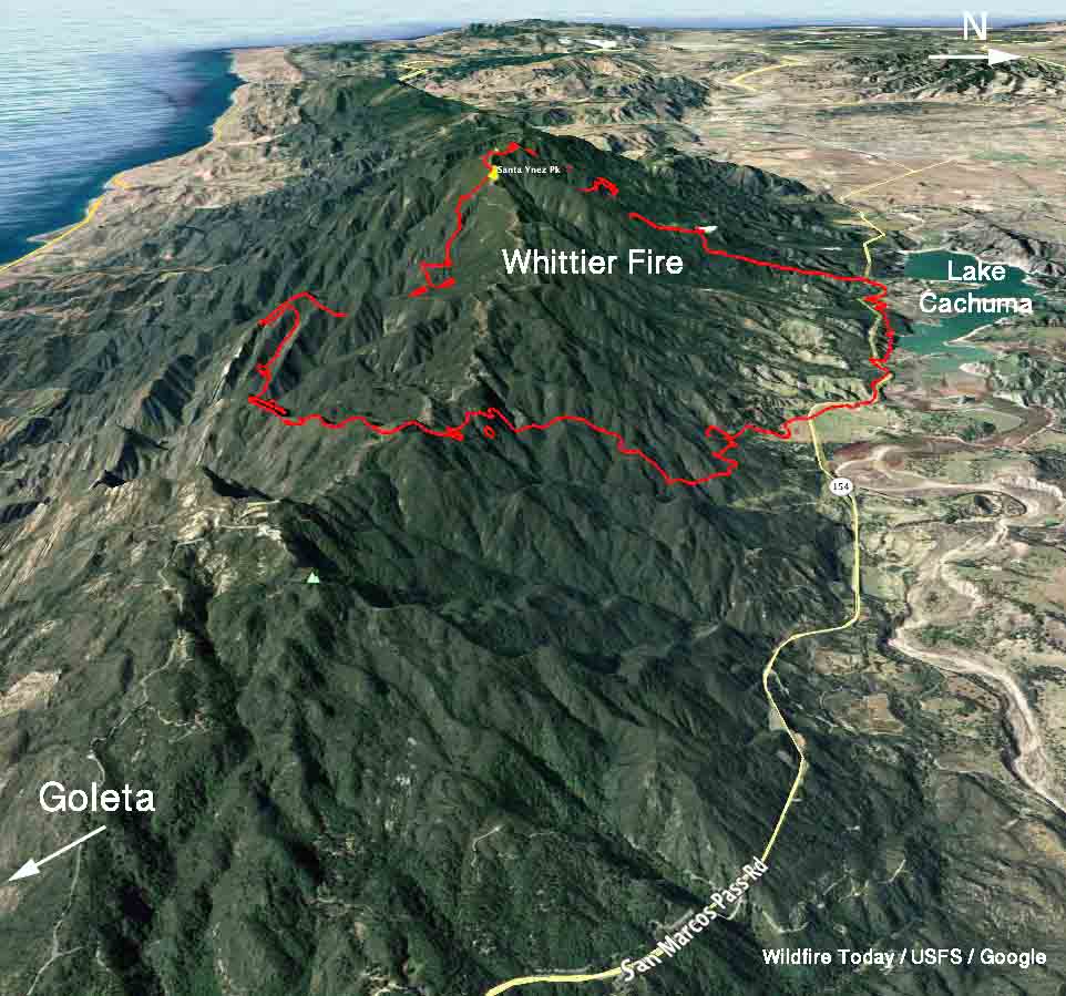
Above: A 3-D map of the Whittier Fire, looking west. The perimeter at 2:30 a.m. PDT on July 11 is shown in red. The white line was the perimeter 28 hours before.

(Originally published at 7:38 a.m. PDT July 11, 2017)

The Whittier Fire six miles northwest of Goleta, California showed moderate growth on Monday. The most active areas were the south side and the upper slopes on the east and west sides. The Incident Management Team has not changed the reported size yet and is still calling it 10,823 acres.  The onshore breeze, higher humidity, and cooler temperatures worked in favor of the firefighters.

On Monday dozers worked the east flank from the Winchester Gun Club toward Hwy. 154. On the west side firefighters improved initial firelines and scouted for an area to complete the line up to Santa Ynez Ridge.
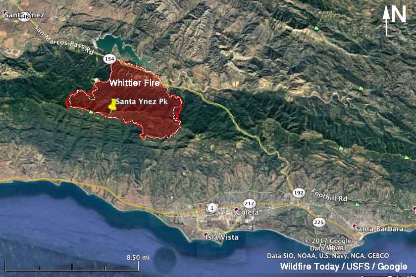
Whittier fire map
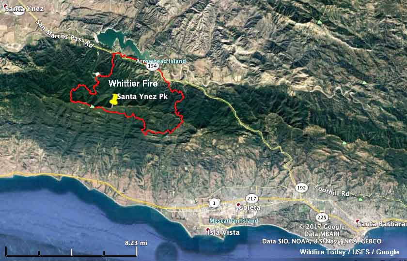
The perimeter of the Whittier Fire at 2:30 a.m. PDT on July 11 is shown in red. The white line was the perimeter 28 hours before.

Retardant lines are temporarily holding the south line while the incident management team works with local ranchers and residents to determine the best location for a fire line north of Goleta.

Most of the area within the perimeter of the fire has not burned since the Refugio Fire in 1955. Over the last several years these fuels have been stressed by the exceptional drought conditions and a high percentage of the fuel bed is dead. The combination of old, dry fuels with a newly cured heavy grass crop contributed to the rapid growth of this fire.

A total of 842 firefighters are assigned, including 97 fire engines, 11 hand crews, 8 dozers, 8 helicopters, and 2 water tenders.

The 20 structures that burned during the early stages of the fire included 8 residences and 12 outbuildings.

The weather forecast for the north side of the fire today predicts mostly sunny skies, 84 degrees, 40 percent relative humidity, and 7 mph southwest winds gusting to 12. Similar conditions are expected to continue through Thursday.

The photo below makes me wonder if binoculars were available during the briefing.

All of the articles we have written about the fire are tagged “Whittier Fire” and can be found here, with the most recent at the top.

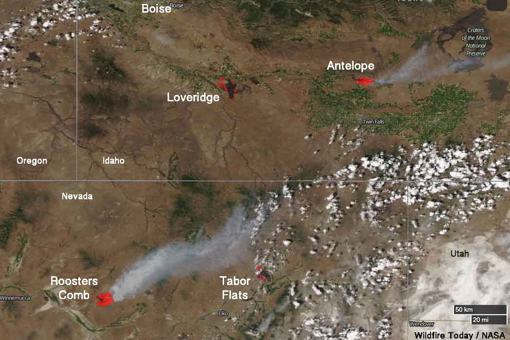
Satellite view of four wildfires in Idaho and Nevada

Above: Smoke from the Roosters Comb Fire was captured in a photo by the (non-operational) GOES-16 satellite at 7:30 p.m. MDT July 10, 2017.

(Originally published at 7:20 a.m. MDT July 11, 2017)

Four wildfires in northeast Nevada and southern Idaho are large enough that satellites are able, in some cases, to see the smoke and the blackened burned areas. These photos were taken late in the afternoon on Monday July 10.

The one putting up the most smoke Monday was the Roosters Comb Fire which as of Monday evening had burned approximately 25,000 acres in Nevada 17 miles northeast of Battle Mountain. It was reported at 9 p.m. Sunday July 9. The fire is spreading rapidly through grass, sagebrush, and pinyon-juniper.

smoke Roosters Comb fire Nevada Idaho
Four wildfires in Nevada and Idaho were photographed by a satellite Monday afternoon, July 10, 2017.

Farther to the east in Nevada is the Tabor Flats Fire 27 miles northeast of Elko close to Interstate 80. The reported size of this fire is also 25,000 acres. The fire behavior in the tall grass is described as “extreme, running, flanking, wind driven runs”.

In Idaho the Loveridge Fire has burned over 38,000 acres 18 miles south of Mountain Home. It was shown as contained in the Tuesday morning national situation report. The heat detected by the satellite in that area (shown as red dots) could either be from the Loveridge Fire or a new fire in the same area.

The Antelope Fire at Shoshone, Idaho just south of Interstate 84 has covered 29,500 acres. It is exhibiting extreme fire behavior with wind-driven runs.

US Forest Service firefighter dies during physical training

On July 8 a firefighter on the Six Rivers National Forest died during physical training activities, according to media articles and the Wildland Firefighter Foundation which reported that the Forest issued this press release.

****

“Dear Six Rivers Family and Friends,

It saddens me to announce the untimely death of a William Jaros. William, Bill a firefighter with the forest service for over twelve years was with engine crew 312 assigned to the Gasquet/NRA Ranger District.

[Saturday June 8], Bill was on a conditioning hike with several crew members and became ill, then collapsed. Immediate life-saving efforts were initiated, however Bill was not able to be revived.

William Jaros
William Jaros. Six Rivers NF photo.
USFS LEI helped us inform Bill’s next of kin in a Georgia early today and so I’m sending this out immediately after the family is notified.

A Critical Incident Stress Management team was been requested and are in route to the Gasquet/NRA district to support all that would like to talk about this sudden and tragic loss of life.

In accordance with agency protocols, a serious incident team will be arriving on the Gasquet/NRA district to gather all information concerning the loss of our fallen Six Rivers Family member. I will personally be on the Gasquet/NRA Ranger district to assist in all aspects related to Bills passing.

As we get more information surrounding Bill’s sudden and untimely passing, I will provide you this information in a timely manner. It is my intention to have an all Forest Members VTC meeting on Monday to provide you with the latest information as it becomes available.

My heartfelt condolences goes out to all that have served with Bill. This is a difficult time for the forest, and together we will make it through.
My heart and prayers goes out to the family, friends and colleagues of Bill—it is a loss for us all.

Sincerely
Michael Green
Acting Forest Supervisor”

****

Our sincere condolences go out to Mr. Jaros’s family, friends, and coworkers.

Red Flag Warnings, July 10, 2017

The National Weather Service has issued Red Flag Warnings for areas in Nevada, Oregon, Washington, Utah, Idaho, Montana, and California. A Fire Weather Watch is in effect for a portion of eastern Idaho.

The map was current as of 8 a.m. MDT on Monday. Red Flag Warnings can change throughout the day as the National Weather Service offices around the country update and revise their forecasts.

Update on the Alamo Fire east of Santa Maria, Calif.

Above: Map of the Alamo Fire east of Santa Maria, California. The red line was the perimeter at about 10 p.m. PDT July 9. The white line was the perimeter about 22 hours earlier.

(Originally published at 9:11 a.m. PDT July 10, 2017)

On Sunday and Sunday night satellites did not find a great many large heat sources on the Alamo Fire east of Santa Maria, California. However they did detect a fair amount of heat on the south end and on the east side near the fire’s edge.

CAL FIRE is calling it 28,926 acres. Technically, that is an increase of about 5,000 acres over the previous 24 hours, but some of that could be due to more accurate mapping.

Portions of Highway 166 and Twitchel Canyon Road are closed. Mandatory evacuations are in effect for Tepusquet Canyon.

A sea breeze on Monday will moderate conditions to be more in favor of the firefighters. The prediction for the fire area is 80 degrees, a minimum relative humidity of 46 percent, and winds out of the west at 7 to 10 mph gusting up to 15.

Whittier Fire was very active Sunday, but was slowed overnight by high humidity

Above: Whittier Fire, looking west from Santa Ynez Peak at 5:53 a.m. PDT July 10, 2017.

(Originally published at 6:25 a.m. PDT July 10, 2017)

The Whittier Fire was very active all day Sunday and into the evening and as of 10:30 p.m. a mapping aircraft observed intense heat along most of the perimeter. The exception was the north side near Lake Cachuma and the lower slopes along San Marcos Pass Road.

Sunday night after midnight the relative humidity at Santa Ynez and Los Prietos climbed into the 60s and 70s and by dawn some of the cameras on Santa Ynez Peak captured what looked like either fog or smoked trapped in a valley inversion.

map Whittier Fire
Map of the Whittier Fire showing the perimeter acquired from an aircraft at 10:30 p.m. PDT July 9, 2017. Click to enlarge.

The Incident Management Team announced Monday morning the fire has burned 10,823 acres. Evacuations are still in effect and San Marcos Pass Road, Highway 154, is closed.

The weather forecast for the fire area on Monday is moderate by fire behavior standards. Temperatures on the north side of the fire near Lake Cachuma should be in the low 80s, the relative humidity in the low 40s, and a sea breeze will be southeast to southwest at 7 to 9 mph with gusts up to 14.

map Whittier Fire 3-D
3-D map of the Whittier Fire showing the perimeter acquired from an aircraft at 10:30 p.m. PDT July 9, 2017.
Whittier Fire
Looking north from Santa Ynez Peak at 5:53 a.m. PDT July 10, 2017.

All of the articles we have written about the fire are tagged “Whittier Fire” and can be found here, with the most recent at the top.