USFS having difficulty hiring firefighters to suppress wildfires in area contaminated with asbestos

The U.S. Forest Service is trying to fill positions on a very specialized 10-person wildland firefighting crew. The mission of the crew would be to suppress wildfires that occur near a mining site at Libby, Montana where vermiculite contaminated with asbestos was extracted by the Zonolite Corporation and later by W.R. Grace from 1919 until the mine closed in 1990. The asbestos became airborne and deposited in the adjacent forest and other areas. Wastes from the mine were used throughout Libby in many public places such as school tracks, public parks, baseball fields, as insulation in public buildings and schools.
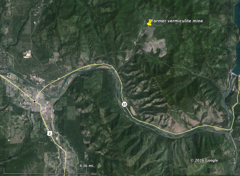
former vermiculite at Libby, MT
Map showing the location of the former vermiculite at Libby, MT. Click to enlarge.

The area is now designated by the Environmental Protection Agency as a Superfund Site. The first public health emergency ever declared by the EPA was the Libby asbestos site in 2009. Hundreds of asbestos-related disease cases have been documented in the small community, which covers the towns of Libby and Troy.

Below are excerpts from an article at The Western News:

…As part of a previous agreement, the Forest Service is responsible for fire containment and cleanup in the mine area. Libby District Ranger Nate Gassmann said having a team located in the area is critical to containing the threat of airborne asbestos if that case were to happen.

“Both agencies understand that importance if the community of Libby and the surrounding area is affected by fire in someway,” Gassmann said. “We do not take this as a light consideration for the Forest Service.

Christina Progess, remedial project manager for Operable Unit 3, known also as the former W.R. Grace mine site, said that the EPA worked hand-in-hand with the Forest Service to develop the action plan, while state agencies like the Department of Environmental Quality and Department of Natural Resources and Conservation took support roles, providing input while the plan was under development. Progess said the plan released on Tuesday has been in the works since spring of 2016.

The team would be composed of Forest Service firefighters, according to the plan, but filling that roster has already proven difficult. According to the memo, Forest Service Fire Managers have discussed firefighting within OU3 with Forest Service firefighters and “most have indicated that they would refuse to work in OU3 due to the presence of (Libby Amphibole asbestos) in forest duff and tree bark.”

Gassmann said while efforts to build the team has been met with hurdles, some support positions have already been filled and the Forest Service may begin looking to outside sources to compose the 10-person squad.

Gassman also said the Forest Service has provided forest fire containment in the mining area before, including two incidences in 2015, although those fires totaled a .75-acre area.

“On average, we receive four fires a year” in the former mine area, Gassman said. “Sometimes you get more, sometimes you don’t.”

Progess said the EPA and Forest Service conducted a test burn earlier this year to determine the exposure levels found in the smoke and ash of a fire in the former mine area. The test burn was a small fire, she said, but the exposure levels were great.

“We had the test burn and had firefighters do some mop up in the area. We found that their exposures were well above the risk target set by the EPA,” she said.

“Exposures were significant and of concern.”

Progess said that if a large forest fire were to tear through the former mine site, the EPA is currently unable to quantify how far or how concentrated the mobilized asbestos would travel through smoke and ash.

“There’s so many variables that would factor into it, from wind to topography to the relative humidity,” she said. “We don’t have any way of understanding what the concentrations would be to residents in Libby but the best way to minimize exposure is to prepare to stop a fire.”

Gassmann said while the primary objective is to keep area residents safe from such asbestos exposure levels, there’s plenty of concern for the safety of the firefighting team, once that crew is assembled.

“We have a requirement to provide health and safety for our fire fighters. That’s above and beyond what you would consider a normal fire fighting activity,” he said.

Cliff Creek Fire continues to spread north of Bondurant, Wyoming

(UPDATED at 11 a.m. MDT July 22, 2016)

The DeMasters Type 2 Incident Management Team released a little more information about the Cliff Creek Fire that has forced the closure of Highway 189/191, one of the highways leading to Yellowstone and Grand Teton National Parks. The size is now 11,534 acres. One structure has burned.

Teton County Emergency Management issued a mandatory evacuation order for the Granite Creek area including Granite Campground, Granite Hot Springs, Jack Pine Summer Homes, and the Safari Club.

For official evacuation information check the Teton County Emergency Management web site.

The U.S. Forest Service and the Incident Management Team state in the update, as they have before, that “The fire is being actively suppressed”, but that is not entirely true. The Bridger-Teton National Forest has directed the Team to use a “confine/contain” strategy. This means they will attempt to herd it around and put out portions of the fire edge as it becomes necessary. But the objective is not to fully suppress the fire. They are no doubt “actively suppressing” some sections of the fire where it endangers private property and structures, but “confine/contain” usually refers to allowing some areas of a fire to spread unconstrained.  They may decide to allow the fire to advance unfettered to the east and northeast into the higher elevations above 9,000 feet where it will begin to run out of fuel.

It was no accident that the “actively suppressing” language was chosen for the press release. The U.S. Forest Service should not issue intentionally misleading information to the public.

****

(UPDATED at 7:53 a.m. MDT July 22, 2016)

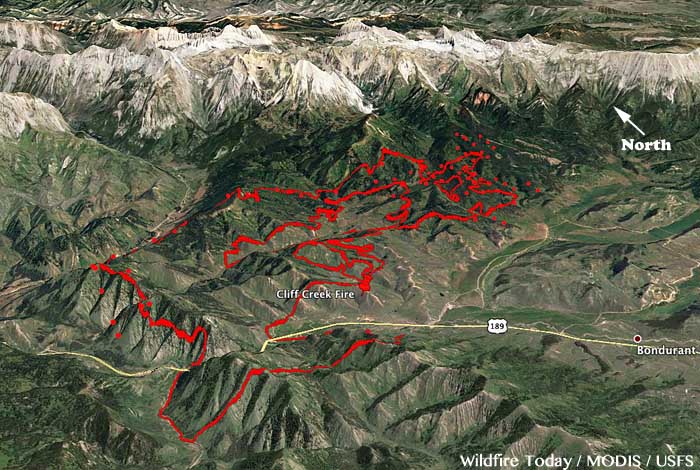
map Cliff Creek Fire
The red dots represent heat detected by a satellite on the Cliff Creek Fire at 2:55 a.m. MDT July 22. The red line was the perimeter about 52 hours before. Click to enlarge.

As the Cliff Creek Fire burns into its sixth day the U.S. Forest Service and DeMasters’ Type 2 Incident Management Team are not releasing much information about the fire which has closed for several days Highway 191, a major highway leading to Yellowstone and Grand Teton National Parks. The fire 12 air miles southeast of Hoback, Wyoming is not being totally suppressed, but is a “confine/contain” fire, which means they will attempt to herd it around and put out portions of the fire edge as it becomes necessary.

One structure and 10,118 acres have burned. Evacuations for the community of Bondurant have been lifted.

The fire was discovered on the Bridger-Teton National Forest at 2:30pm on Sunday, July 17, approximately 5 miles north of the town of Bondurant Wyoming.

It is being managed by 620 personnel, 16 hand crews, 33 engines, and 7 helicopters at a cost to date of $2,200,000.

****

(UPDATED at 11:54 a.m. MDT July 20, 2016)

Cliff Creek Fire
Cliff Creek Fire July 20, 2016. USFS photo.

The Cliff Creek Fire 3 miles north of Bondurant, Wyoming continued to spread over the last 24 hours to the north and east. It has consumed approximately 7,671 acres and one structure.

Continue reading “Cliff Creek Fire continues to spread north of Bondurant, Wyoming”

Federal government seeks to recover $25 million in costs for the 2013 Mountain Fire

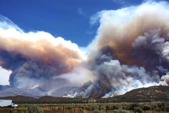
Mountain Fire, from Hwy 74
Mountain Fire, from Hwy 74, July 17, 2013. USFS Photo by Sam Wu.

The United States federal government has filed suit to recover the costs of the suppression and damage caused by the 2013 Mountain Fire that burned 27,500 acres. Most of the fire was in the San Bernardino National Forest in southern California. The lawsuit seeks nearly $25 million in damages from the owner of a Mountain Center residence and the property’s caretakers for alleged negligence that led to the fire.

The civil complaint alleges negligence and violations of California law as being the cause of the fire that started on July 15, 2013, and burned a large swath of the San Jacinto Mountains, for a time threatening the town of Idyllwild and forcing over 5,000 residents to evacuate. An investigation determined that the fire started when an electrical discharge inside of an improperly maintained electrical junction box “shot sparks and hot material out of the box and onto dry ground vegetation below,” according to the lawsuit.

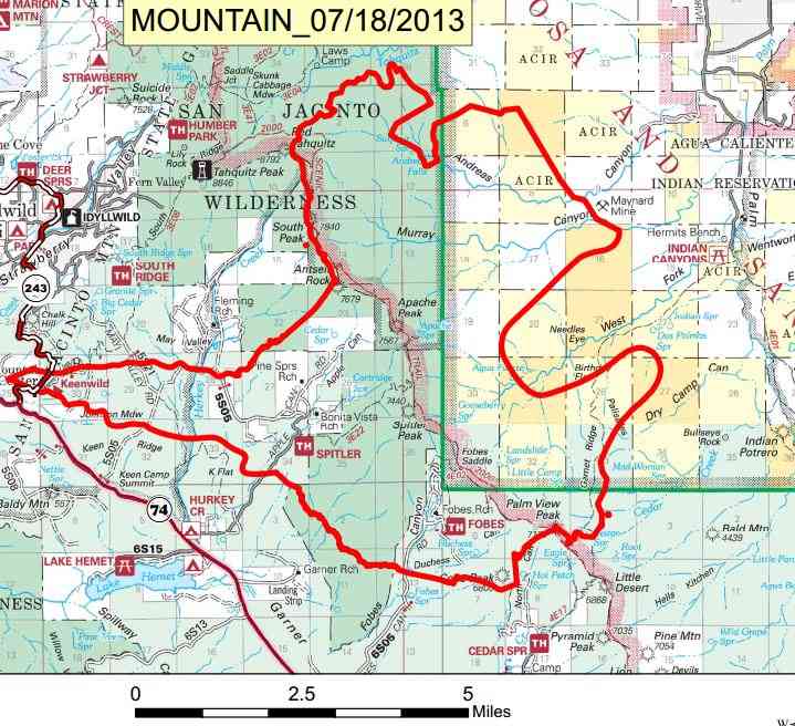
Map of Mountain Fire
Incident Management Team map of Mountain Fire, July 18, 2013 a few days before the spread was stopped.

The Mountain Fire started on property known as Gibraltar West that is owned by Tarek M. Al-Shawaf, who is the lead defendant in the lawsuit.

The defendants had a duty “to properly inspect and maintain their electrical equipment, electrical wires, and electrical junction boxes to ensure that they were safe, properly secured, and clear from dangerous conditions,” the complaint alleges.

“In addition to endangering countless lives, including those of firefighters who battle these large-scale blazes, the failure to properly manage the property and the electrical equipment on the property in this case cost taxpayers approximately $24 million dollars,” said United States Attorney Eileen M. Decker.

The complaint specifically alleges that the Forest Service spent more than $15 million to fight the fire, that the fire caused more than $9 million in damages to natural resources, and that more than $300,000 had to be spent to perform emergency rehabilitation.

Articles on Wildfire Today tagged “Mountain Fire”.

Moderate weather and air tankers slow the Indian Canyon Fire near Edgemont, South Dakota

Above: The north side of the Indian Canyon Fire along the Cheyenne River late in the evening of July 17.

(UPDATED at 7 p.m. MDT July 18, 2016)

Around noon on Monday we visited the west side of the Indian Canyon Fire south of Edgemont, South Dakota. It was very quiet. Not much was going on at the airport, the incident command post, or along Highway 471. We only saw one location that was putting up much smoke and it was on the north side in some cottonwood trees near the Cheyenne River. That area probably has logs and dead trees that could smoulder for days.

Art Prints

The order for the Type 1 Incident Management Team was cancelled. The latest size estimate for the fire is 13,500 acres. At 9 a.m. today the incident management team reported there was zero containment on the fire. Then at 4:06 p.m. that increased to 60 percent. This just illustrates that containment numbers are meaningless most of the time and is the reason why we rarely regurgitate that statistic.

The six photos in the next gallery were taken around noon on Monday. Scroll down to see two other galleries. Click on a photo to see a larger version, then click on the arrows to view more.

****

(UPDATED at 10:28 a.m. MDT July 18, 2016)

Monday morning the Great Plains Fire Information office reported there had been “heavy rain” on the Indian Canyon Fire in South Dakota. When I left the Edgemont area at 7:30 Sunday night a thunderstorm was moving in and light rain was falling. Two rain gauges that are near the fire but not within the perimeter recorded 0.03″ and 0.07″ overnight.

The heat-sensing satellite did not detect any large heat sources Sunday night on the fire. That does not mean it is out. The sensors, about 200 miles overhead, can only “see” large concentrations of heat. And the grass, which comprises most of the vegetation in the fire area, can burn and then cool before the next satellite overpass.

The behavior of the fire on Sunday was affected by the moderate weather conditions — temperature around 80, relative humidity in the 30’s, and an 8 mph east wind. The forecast for the fire area on Monday predicts 96 degrees, southwest winds of 14 to 18 gusting in the mid-20’s, and 30 percent relative humidity. These conditions could dry much of the Sunday night rainfall.

Another factor slowing the fire was the use of air tankers, helping to keep the fire out of Edgemont. In addition to a DC-10 Very Large Air Tanker, seven other air tankers were used on the fire Sunday — four Single Engine Air Tankers and three large air tankers, T-02 and T41 (both BAe-146’s), and T-45 (a P2V). In addition, two National Guard Blackhawk helicopters worked on the fire Sunday.

The photos in the gallery below were shot around 7 p.m. MDT Sunday night. To see larger versions, click on one, then click the arrows to see more.

This was the first time that a Very Large Air Tanker has dropped retardant in the state of South Dakota. It carries 11,600 gallons, far more than any other air tanker currently certified in North America. The other Large Air Tankers hold between 2,000 and 4,500 gallons. Global Supertanker has a 747 Very Large Air Tanker with a 19,600-gallon capacity working its way through the FAA and Interagency AirTanker Board approval process.

Continue reading “Moderate weather and air tankers slow the Indian Canyon Fire near Edgemont, South Dakota”

Red Flag Warnings, July 16, 2016

Red Flag Warning, July 16, 2016 wildfire

The National Weather service has posted Red Flag Warnings or Fire Weather Watches for areas in California, Idaho, Arizona, Wyoming, Utah, Nevada, and Colorado.

The maps were current as of 10:15 a.m. MDT on Saturday. Red Flag Warnings can change throughout the day as the National Weather Service offices around the country update and revise their forecasts and maps. For the most current data visit this NWS site.

wildfire Red Flag Warning, July 16, 2016