Wildfire season 2015: very busy in some areas, slow in others

Chelan Fires
First Creek Fire at Lake Chelan, Washington, 2015. USFS photo by Kari Greer..

(Updated February 26, 2016 to include the final fire occurrence statistics for 2015.)

As the 2015 wildfire season draws to a close in most areas of the United States, preliminary numbers for acres burned show at first glance that it has been very busy. According to statistics from the National Interagency Fire Center, 10,125,149 acres burned in the country which is the most recorded during the last 55 years when accurate records have been kept.

But if we drill down into the statistics we find that more than half of those acres were in Alaska, with 5.1 million acres, more than quadruple their average of 1.2 million and the most acres burned since 2004 (6.6 million). Fire management in Alaska is very different from the rest of the country. Most of the huge state is very sparsely populated, making it possible for land managers to allow some large fires to burn virtually unchecked except where they might impact a structure or village. In those areas “point protection” is the key — establishing firelines, sprinkler systems, or burnout operations for relatively small areas, leaving the rest of the fire untouched.

In the other 49 states (we like to call them the “lower 49 states”) 5.0 million acres burned so far in 2015, about 700,000 less than the average of 5.7 million acres.

We don’t have the individual totals for each of the lower 49 states yet for this year but the impression is that firefighters were very busy in northern California, Washington, Oregon, Idaho, and parts of Montana, while it was much slower than average for the other western states.

Concerns about the drought in California had many wildfire organizations sitting on pins and needles as the summer began. Los Angeles County usually contracts for two water scooping air tankers for their fall fire season which often has large fires pushed by very strong Santa Ana winds accompanied by single-digit humidities. Angst about the drought-desiccated fuels caused LA County to double their contracted air tanker fleet from two to four. While the northern part of the state had numerous large fires, the last half of the summer farther south was relatively benign, fire-wise.

Rain across much of the northwest in early September knocked out most of the large fires that had been chewing up acres in August. Even southern California received rain off and on in the fall. Orange County near Los Angeles got almost two inches of rain on September 15. Officials were dealing with flooding in Newport Beach and telling residents where they could obtain sandbags, something very rare in that area, but especially in September, the dry season.

Work continues to design improved fire shelter

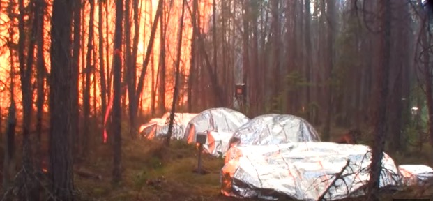
Fire Shelter Tests in Canada, June 2015.

Since we last reported on the effort to develop a better fire shelter, additional tests have been carried out on some of the more promising materials.

The image above is from tests during actual forest fire conditions in June when NASA’s Langley Research Center, the University of Alberta, and the U.S. Forest Service travelled to Fort Providence in Canada’s Northwest Territories to conduct a series of controlled outdoor burns. More tests were held in September in a full-scale fire testing facility at the University of Alberta in Edmonton.

This is all part of a project that led to the creation of an organization, working with NASA and other organizations, called CHIEFS – Convective Heating Improvement for Emergency Fire Shelters – a team that is working to take its knowledge of heat-shield technology for space missions and use it to help improve fire shelter technology here on Earth.

A fire shelter is a folding pup tent like device that is intended to shield wildland firefighters from radiated and convected heat if they become trapped in a wildland fire. The U.S. Forest Service moved up their plans to improve the last-resort device after 19 firefighters were killed even after they deployed shelters on the Yarnell Hill Fire in 2013 south of Prescott, Arizona.

After the tragedy NASA got involved thinking that heat shields they had developed for space craft experiencing the heat of re-entry into the atmosphere might be useful in a new generation of fire shelters.

Mary Beth Wusk, a NASA integration manager in the Game Changing Development Program Office at Langley, said in the video below that the work she has done on this project has been the highlight of her career.

Thanks and a tip of the hat go out to Bean.

The Quiet Professionals

Danny Fairchild posted this video December 3, 2015, titled “The Quiet Professionals”. His description:

“For the quiet professionals you will only meet when there is an emergency. Thank you all Park Rangers, Wildland Firefighters, SAR Teams, and First Responders.

Special Thanks to:

Wildland Fire:
Merritt Fire Devils, British Colombia, Canada
East Divide Handcrew – Denver, CO
Sawtooth Hotshots – Twin Falls, ID
Fort McMurray Helitack –Alberta, Canada
Sequoia-Kings Helitack – Three Rivers, CA
Malheur Rappellers – John Day, OR
Salmon Rappellers – Salmon, ID
North Cascades Smokejumpers Base – Winthrop, WA
McCall Smokejumper Base – McCall, ID

Locations
Banff National Park – Alberta, Canada
Grand Canyon National Park, AZ
Sequoia-Kings National Park, CA
Denali National Park, AK
Mount Rainier National Park, WA
Devils Tower National Monument, WY
Zion National Park, UT
Lake Tahoe, CA
Las Vegas, NV
And More…

Agencies:
United States Army – 1-52 Aviation Battalion
California Air National Guard – 146th Airlift Wing
Wyoming Air National Guard – 153rd Airlift Wing, MAFFS
National Interagency Fire Center, Boise ID
National Park Service
United States Forest Service
Bureau of Land Management
Las Vegas Metropolitan Police Search and Rescue
SOG Knives Company
GoPro
Black Diamond”

****

Mr. Fairchild’s video below, uploaded a year ago, “is dedicated to all FIRE, EMS, LE’s, SARTECH’s, and other Visitor Protection Services personnel. Best job in the world”.

NASA releases video about Suomi NPP fire-detecting satellite

NASA released a video this week that explains some of the features of the Suomi National Polar-orbiting Partnership (Suomi NPP) satellite that was launched October 28, 2011. The Visible Infrared Imaging Radiometer Suite (VIIRS) on the satellite is a 22-band radiometer designed to collect infrared and visible light data to observe wildfires, movement of ice, and changes in landforms. It has a resolution of 375 meters, much better than the MODIS satellite data with 1,000-meter resolution. The MODIS was launched in 1999.

The combination of the VIIRS data (that is updated twice a day), weather forecasts, and fire behavior modeling software developed by Janice Coen and Wilfrid Schroeder, can result in more useful fire spread forecasts for fire managers.

Wildfire potential through March, 2016

On December 1 the Predictive Services section at the National Interagency Fire Center issued their Wildland Fire Potential Outlook for December, 2015 through March, 2016. The data represents the cumulative forecasts of the ten Geographic Area Predictive Services Units and the National Predictive Services Unit.

If their forecasts are accurate, it looks like a continuation of pretty benign conditions across the United States this winter.

Here are the highlights from their outlook.

December
December wildfire 2015 Outlook

  • Significant fire potential is normal across the majority of the U.S.
  • Below normal significant wildland fire potential will persist across most of the Southeastern U.S. and Puerto Rico.

January
January 2016 wildfire Outlook

  • Significant fire potential is normal across the majority of the U.S.
  • Below normal significant wildland fire potential will persist across most of the southeastern U.S. and Puerto Rico.

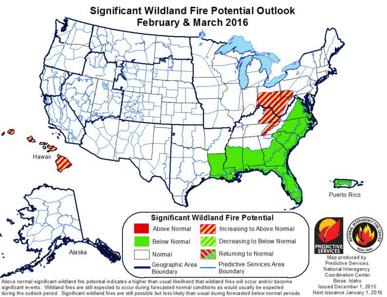
February-March
February-March 2016 wildfire Outlook

  • An area of above normal significant fire potential will develop across the central interior portion of the eastern U.S. Above normal potential will also affect the Hawaiian Islands.
  • Below normal significant wildland fire potential will persist across most of the Southeastern U.S. and Puerto Rico.
  • Significant fire potential is normal across the majority of the U.S.

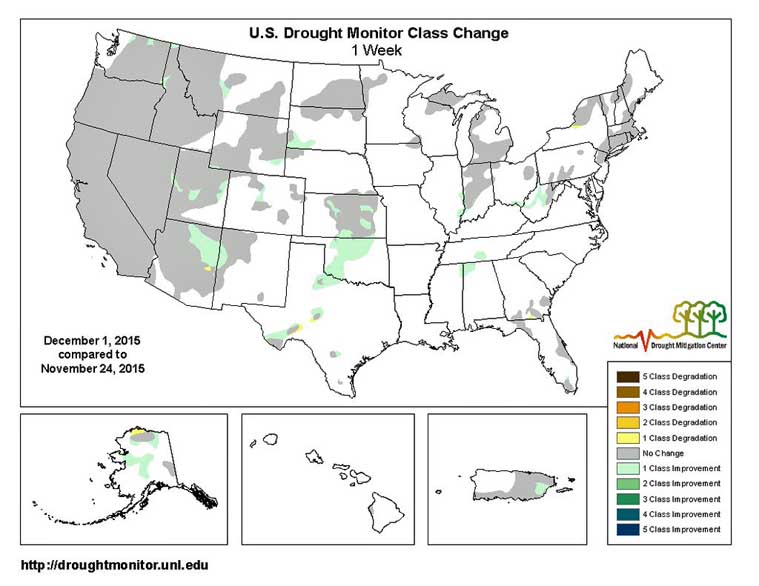
And as a bonus — the Drought Monitor:

Drought Monitor December 1, 2015

Drought Monitor Change

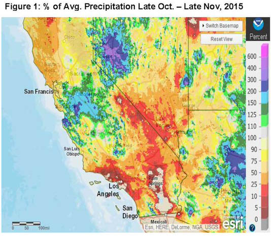
Bonus #2, Percent of Normal Precipitation:

Precip percent of normal California