CAL FIRE reports 135 residences burned in the Butte Fire

A September 16 update on the Butte Fire is in a new article.

****

(UPDATED at 12:17 PT, September 14, 2015)

The Butte Fire south of Jackson, California has grown by about 6,000 acres in the last two days and is now listed at 71,063 acres.

CAL FIRE reports that 135 residences and 79 outbuildings have been destroyed.

Fire behavior remained moderate on Sunday allowing crews to be more effective in constructing fireline on the perimeter.
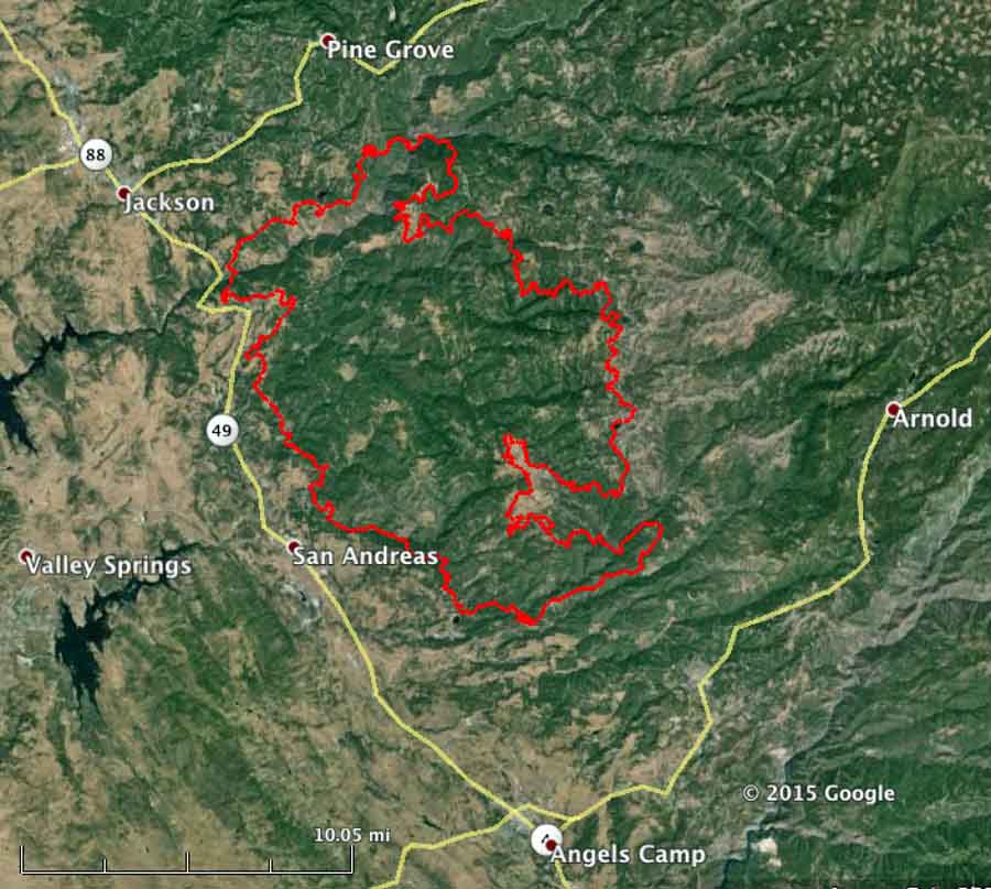
butte fire map
Butte Fire map, 9-13-2015. CAL FIRE.

Evacuations are still in place for many areas in Amador and Calaveras Counties. More details are available at the fire information phone lines: (530) 647-5218 and (209) 754-5527.

****

(UPDATE at 10:35 p.m. PT, September 12, 2015)

In a 9:15 p.m PT update from CAL FIRE, the size of the Butte Fire south of Jackson, California remained about the same during the day on Saturday, but damage assessment teams reported that they counted 86 homes and 51 outbuildings that burned in the fire.

Mandatory evacuations are still in place for numerous locations in Amador and Calaveras Counties. More details are available at the fire information phone lines: (530) 647-5218 and (209) 754-5527.

Over 3,800 personnel are assigned to the fire, along with 452 fire engines, 77 hand crews, 17 helicopters, and 94 dozers.

****

(UPDATED at 9:43 a.m. PT, September 12, 2015)

West Point E312
Engine 312 from the West Point Fire Protection District. Photo by SLOStringer, used with permission.

Two close calls have occurred on the Butte Fire south of Jackson, California. A truck from the West Point Fire Protection District burned in the private driveway of a home along Highway 26 . The person who took the photo above said it appeared the crew was doing structure protection and that they were able to avoid any major injuries.

The Modesto Bee has an article about “Modesto and Stanislaus Consolidated crews” that had to take refuge behind a structure as the fire “made a significant run at them [with] very erratic fire behavior”. The firefighters did not deploy fire shelters, but their vehicles suffered heat damage described as “cosmetic”, including “bubbled paint, melted plastic trim and melted hose”.
Map Butte Fire
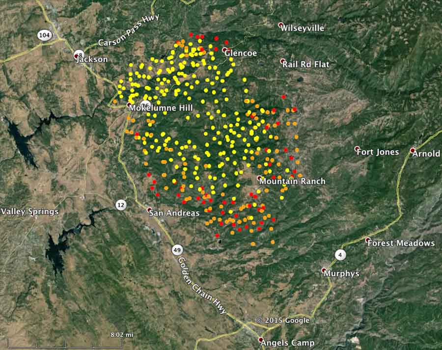
The red dots represent heat detected by a satellite over the Butte Fire at 1:37 a.m. PT, Sept. 12, 2015. The other colors are from earlier satellite overflights. MODIS. (click to enlarge)

CAL FIRE reports that the Butte Fire has burned 64,728 acres and has destroyed 15 structures. Other than evacuations and the number of firefighting resources assigned (3,330 personnel) CAL FIRE has provided little additional information about the fire. Saturday morning they did supply the map below which, although undated, appears to be fairly current.

Map Butte Fire
CAL FIRE’s map of the Butte Fire obtained Sept. 12, 2015. No information was provided about the date of the perimeter.


****

(UPDATED at 5:30 p.m. PT, September 11, 2015)

Butte Fire
The Butte Fire at 6:09 p.m. on September 10, as seen from above Jackson, CA, looking southeast. Photo by Matthew Rhodes.

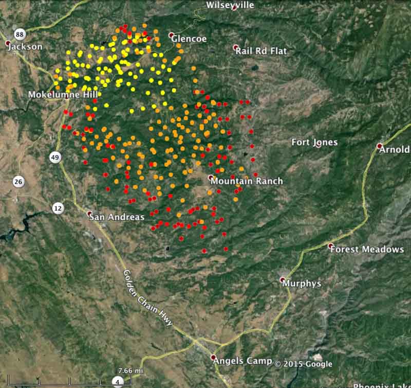
CAL FIRE reported at 3 p.m. today that the Butte Fire south of Jackson has burned 50,000 acres since it started 46 hours before on September 9.

More areas have been added to the mandatory evacuation list in Calaveras and Amador Counties. Details are available at the Fire Information phone line, (530) 647-5218 and (209) 754-5527.
map butte fire
The red dots represent heat detected on the Butte Fire at 1:39 p.m. PT, Sept. 11, 2015. MODIS. (click to enlarge)

Continue reading “CAL FIRE reports 135 residences burned in the Butte Fire”

Colorado Fire Chiefs submit recommendations to legislature committee

On August 24 the Colorado State Fire Chiefs organization provided recommendations to Colorado’s Wildfire Matters Review Committee regarding how to improve the wildfire suppression capabilities within the state.

Below are brief excerpts from their 14 pages of testimony:

****

“…The three highest priority recommendations remain the same as made to the Committee on October 1, 2013 & August 4, 2014

#1 — Insure the stability and reliability of the current Colorado state-wide emergency radio system.

…There is still much to be done to assure seamless interoperability on a routine basis. Further, the progress that has been made is now in jeopardy. .

There are two major trunked digital systems in use throughout the State. The State Digital Trunked Radio System (DTRS) and a Harris system used by Denver, Aurora, and some surrounding jurisdictions. Significant grant funds have been invested in tying these systems together for interoperability.

But, ongoing maintenance challenges with the DTRS has resulted in Weld and Adams counties (Front Range Communication Consortium) purchasing another radio switch, effectively creating yet another radio system that may not provide seamless interoperability with the two existing systems

The reason for the third split is a very real concern that the DTRS is not being maintained by the state and the anticipation that with this maintenance neglect the DTRS will predictably fail…

#2 — Continue to invest in the development, expansion & implementation of the State resource mobilization plan.

If we cannot effectively mobilize, deploy and utilize firefighting resources then the efforts of this committee and the fire services across this state are minimized and lives are placed at risk.

DHSEM received three FTEs as part of HB13-1031 for this purpose. Due to multiple circumstances and back-to-back disasters there has been a delay in filling these three positions. These positions must be filled expeditiously and certainly before the end of 2013…

#3 — Expand the current local, regional and State command, control, and coordination capabilities.

Third in priority, after communications and resource mobilization is a solid incident command system that is rapidly scalable from a single jurisdiction incident to a multi-agency/multi-jurisdiction event

An incident command structure is essential to quickly organizing and efficiently utilizing the firefighting assets that will be mobilized under the State resource mobilization plan.

Investment in the five (5) current All-Hazard Incident Management Teams provides the best all-around ROI for the expenditure of state funding. The AHIMTs are force multipliers for all the local and state resources being managed in any major incident.

The state currently recognizes five (5) Type III All-Hazard Incident Management Teams. These teams are considered a statewide asset, but are all volunteer organized, staffed and funded and they currently receive absolutely minimal support from the state…

#4 — Provide sufficient funding to the Division of Fire Prevention and Control (DFPC) to fulfill its stated missions.

Ensure that all regions of the State have their assigned Fire Management Officers (FMOs). The FMOs are a capability that, when coordinating with a local firefighting force, significantly

increases their firefighting potential and thus enhances the probability of successful mission accomplishment.

However, the FMOs in each region are only one person deep and all FMOs can easily be fully engaged without any backup and sustained 24/7 operations are not possible with the current FMO staffing levels, especially when multiple regions are experiencing multiple fires (which is now considered the normal status operations during wildfire season)

Previously some regions in the state had as many as three district foresters from the Colorado State Forest Service. Funding for the DFPC also provides that initial response from the State to assist local agencies with determining if the fire will be handled locally or what additional resources will be required…

#5 — State aviation resources are an essential and integral part of the initial attack on WUI fires.

Provide funding support for the appropriate mix of firefighting aircraft to fill the gap between what is needed on WUI and wildland fires in Colorado and what the federal interagency system will provide.

The Colorado Air National Guard (Title 32) using its helicopter air support capabilities and fully qualified and trained crews, should become an integral part of the air attack plans and operations for WUI fires in Colorado…”

****

Thanks and a tip of the hat go out to Bean.

California: Oak Fire stopped at 100 acres

A fire in California that reportedly had a great deal of potential was stopped at 100 acres Tuesday by an aggressive initial attack. The Oak Fire northeast of Sonora was reported at 1:23 p.m. and was attacked quickly by troops on the ground, S-2s that were 10 minutes away at Columbia Air Attack Base, a very large air tanker, and a C-130. The Oak Fire and another fire nearby, the Hill Fire, burned together which then was only referred to as the Oak Fire.

KCRA reported that firefighters attending training at a nearby conference center had to be evacuated.

Thanks and a tip of the hat go out to Eric.

The spread of the Tenaya Fire above Yosemite Valley slows

(UPDATE at 10:12 a.m. PT, September 10, 2015)

The Tenaya Fire in Yosemite National Park in California slowed on Wednesday due to the efforts of aviation assets and troops on the ground. In fact the mapped size of 431 acres is a decrease from the estimated 500-acre figure the park released earlier.

The park reports that firefighter efforts at the heel of the fire are holding and good progress is being made on the flanks.

The NPS says this is a “suppression fire” even though three other fires in the park, all currently less than 50 acres, are not being fully suppressed. A Wednesday evening statement from the park said:

Although the use air tankers were initially discouraged, the use of retardant was necessary due to active and rapid rate of fire spread. Key reasons include firefighter and visitor safety, and risks to and closing the Tioga Road, negatively affecting the local communities that rely on park visitation, including the communities include Lee Vining, Mammoth Lakes, Groveland and Mariposa.

Map Tenaya Fire 9-9-15
Map of the Tenaya Fire, Sept 9, 2015. NPS.

****

(Originally published at 7:47 a.m. PT, September 9, 2015)

Tenaya Fire
Tenaya Fire, September 8, 2015. NPS photo.

The Tenaya Fire started September 7 in California’s Yosemite National Park between Yosemite Valley and Tioga Road (Highway 120). It is burning along both sides of the Lehamite Creek Trail from the north rim of the Valley to Tioga Road. (See the map below.)

The Park Service reports that full suppression efforts began on September 8 which included approximately 60 firefighters, six air tankers, and three helicopters. Additional resources will arrive on the fire September 9.

map of Tenaya Fire
3-D map of Tenaya Fire, showing heat detected by a satellite at 1:47 a.m. September 9, 2015. Looking northwest. (Click to enlarge.)

No structures are currently threatened and as of Tuesday night there was no containment on the fire. The cause is under investigation.

Some fire officials concerned about firefighters taking photos

The Associated Press has an article about the increasing trend of firefighters taking photos while they are assigned to a fire, and in some cases sharing them on social media websites.

Below is an excerpt from the article:

…Fire officials, who have seen an uptick in such postings, warn that the act of focusing on a handheld screen can be deadly when crews are surrounded by danger.

“There have been incidents in the past where firefighters have captured the last moments literally of their lives,” said Dave Teter, deputy director chief of fire protection at the California Department of Forestry and Fire Protection.

The problem is especially heightened in California as the parched state makes for an explosive fire landscape.

“Burning conditions and rates of spread and the energy release associated with these fires is really unprecedented,” said Teter.

Cal Fire has discussed the possibility of stripping crews of their cellphones, and the idea remains on the table. The agency says for now, however, it’s trying to avoid such a drastic measure…

What do you think? Is this a problem? Can a fire agency strip crews of their cell phones?