Wildland firefighters called “tactical athletes”

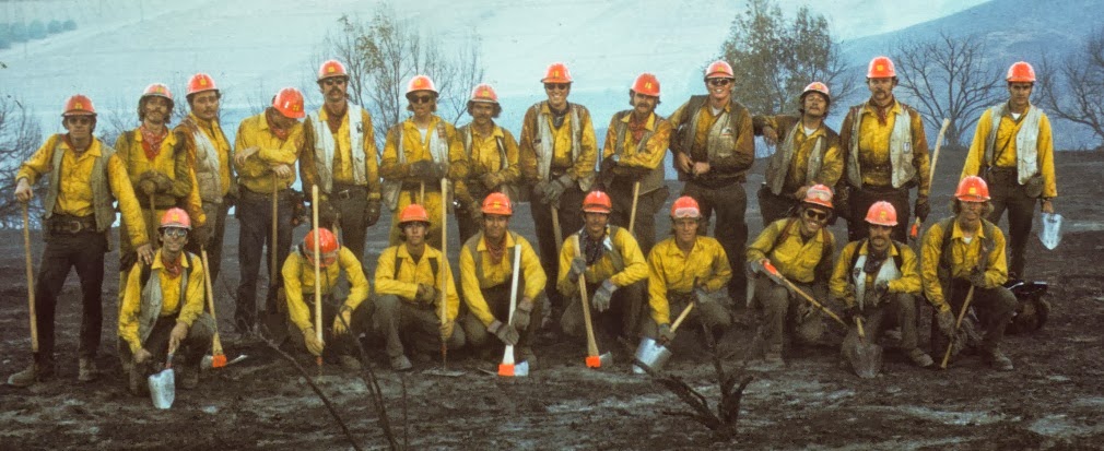
El Cariso Hot Shots, 1972
“Tactical athletes”, also known as the 1972 version of the El Cariso Hotshots (missing  Superintendent Ron Campbell, and Bill Gabbert who was behind the camera). Click to enlarge.

Charles Palmer, who spent 20 years as a firefighter and smokejumper, describes wildland firefighters as “tactical athletes”.

Below is an excerpt from an article in the Seattle Times.

…Physically and mentally, the demands of the profession are such that Charles Palmer, an associate professor at The University of Montana who studies performance psychology of wildland firefighters, considers such workers “tactical athletes.”

“These aren’t people who ride around trucks and squirt water on stuff — this is really demanding from a lot of different angels,” Palmer said. “You travel around, you have to perform, they’re getting very little downtime, they have nutritional challenges … physically you have to perform really well.”

In one study, Palmer screened wildland firefighters for attention-deficit/hyperactivity disorder (ADHD). He said about 20 percent tested above the established cutoff score.

“It’s very possible a high percentage of folks who work as wildland firefighters have ADHD,” he said. “If you start thinking about a profile, people with ADHD are very comfortable with risk. They like fast-paced environments. They like activity. They like moving around.”

Front-line firefighters burn between 4,000 and 6,500 calories each day and need 7-10 liters of water each day, said Brent Ruby, director of the University of Montana’s work physiology department.

“Perhaps the top 10-15 percent of the average population can do this job based on fitness levels,” said Joe Domitrovich, an exercise physiologist with the National Forest Service.

But the Marshawn Lynch comparisons only go so far.

“They don’t get paid like a professional athlete would,” Palmer said. A 2013 National Parks brochure advertises pay of about $10-17 an hour to firefighters, before overtime or hazard pay, but base pay varies widely. Base pay for entry-level state Department of Natural Resources wildland firefighters starts at $12.50…

Kyle Dickman profiles Tom Harbour

The author of On the Burning Edge, a book about the Granite Mountain Hotshot crew that was virtually wiped out fighting the Yarnell Hill fire in 2013, has written a long form article about the August wildfires in the west. A good portion of the piece by Kyle Dickman profiles Tom Harbour, the U.S. Forest Service’s National Director of Fire and Aviation Management. I don’t recall seeing such a personal look at the man who wields power at the top of the USFS firefighting food chain — with the possible exception of when he answered our 12 Questions.

Below is an excerpt from the article:

…To contend with California’s regular fires, the Forest Service set up two command centers, with one, in Redding, called North Ops. Redding sits in a bowl in the Sacramento Valley, and as Harbour arrives, the wind is filling that bowl with eye-stinging smoke. On the grounds, a long-haired smokejumper in flip-flops pedals a cruiser bike around the base while air tankers loaded with fire retardant take off from the runway. The mood isn’t festive, but one feels the excitement and gravity of a shared sense of purpose. The command staff hustle about to send firefighters and gear to the front lines. Several stop to shake Harbour’s hand. He joins a briefing headed by Paige Boyer, the assistant director for fire and aviation management for Northern California.

“We really want to get that fire off the map,” Boyer says to a half-dozen of her colleagues gathered before a map. “We want it out of the public eye.” Boyer taps the northeast corner of the map, where red colors the fire where a firefighter died.

Three days earlier, Harbour had flown to Alturas, Calif., to pay his respects to the family of that engine captain, 38-year-old Dave Ruhl. He’d disappeared while scouting a fire near the city limits. His crew didn’t find his body right away, and while CNN and the Associated Press zeroed in on the details of the first fire death of the 2015 season, Harbour arranged to meet his folks, as he’s tried to do for each of the 163 firefighters—both Forest Service and non—lost on duty in the past 10 years…

Incident managers from Indonesia visit the Rough Fire

Indonesia Command System
Incident management system trainers from Indonesia visit the Rough Fire in California. Inciweb photo.

This article first appeared on the InciWeb page for the Rough Fire, which has burned 66,542 acres near Hume Lake in southern California. Fire managers are calling it 25 percent contained.

****

“Indonesia, which is comprised of a group of 17,500 islands, is considered one of the most disaster prone areas in the world. Not do the mountains move (147 active volcanos), but the ground around the mountains seems to shake with earthquakes daily, reportedly with at least a 5.0 tremor every day. On December 26, 2004 Indonesia recorded the third largest earthquake ever recorded with the longest duration of faulting ever observed. It caused the entire planet to vibrate as much as 1 centimeter and triggered other earthquakes as far away as Alaska.

Shortly after the 2004 earthquake, the government realized that the country needed a system to help manage disasters. The government approached the United States to teach and provide technical expertise on the Incident Command System (ICS) for the tsunami-prone areas. A series of training courses was conducted in partnership with the governments of Sri Lanka and Indonesia.

18 individuals from Indonesia who are considered trainers arrived at the Rough Fire on August 28. They will be traveling to big cities in California to learn and participate in certain aspects of the ICS over the next few weeks. They expected that by arriving in the month of August they would have the opportunity to see the ICS at work during a large incident.

“The Team” will be at the Rough Base Camp to observe certain sections of the command system, so they can pass along their knowledge and educate the other Indonesians about ICS. On one particular Island, the team stated they have over five thousand trained volunteers. Many islands in Indonesia are difficult to access, similar to The Rough Fire. The team has changed the name of the management system to “Indonesian Command System”.”

****

Installing a hose lay on the Rough Fire. Undated InciWeb photo. (We think this is not the group from Indonesia.)

Thanks and a tip of the hat go out to Barbara.

Smoke Map and Red Flag Warnings, Aug. 30, 2015

Red Flag Warnings, Aug. 30, 2015

The National Weather Service has issued Red Flag Warnings for Montana and Wyoming.

The map was current as of 9 a.m. MDT on Wednesday. Red Flag Warnings can change throughout the day as the National Weather Service offices around the country update and revise their forecasts and maps. For the most current data visit this NWS site or this NWS site.

Smoke severity has dissipated greatly from the Pacific Northwest fires, although some “unhealthy” air quality advisories remain in place for Idaho and Montana.

Smoke map, Aug. 30, 2015

To see the most current smoke reports on Wildfire Today, visit the articles tagged “smoke” at https://wildfiretoday.com/tag/smoke/

Given forecast, meteorologist thinks crews should have been pulled from Twisp fire

twisp river fire fatalities
The general area of the fatalities. They were found 40 feet off Woods Canyon Road. The 3-D map is looking north.

Could the fatal fire behavior near Twisp, Washington have been predicted?

One scientist, Cliff Mass, a professor of atmospheric sciences at the University of Washington, thinks the erratic winds on Aug. 19 that fueled the flames that killed three firefighters were forecasted at least a day before.

In a recent blog post, Mass gave an in-depth analysis of wind patterns and weather on Aug. 19 to back-up his assertion that all crews should have been pulled from the line before the winds picked up.

“I believe the windshift/wind acceleration that occurred Wed. afternoon was entirely predictable.  It was not random, it was not extreme or a new normal,” Mass wrote. “My profession needs to work with the fire community to ensure such tragedies are prevented.”

The goal of the blog isn’t to place blame, Mass said, but instead to highlight an important issue while there are still crews fighting fires around the Pacific Northwest.

Cliff Mass blog, Aug. 30, 2015

Mass’ analysis of the models shows a major wind transition across the Cascades between noon and 3 p.m. But Mass also found weather prediction models released at 5 p.m. the day before that predicted the same shift in winds.

“Thus, wildfire folks should have been pre-warned of a major wind shift and acceleration and probably should have been pulled back that afternoon,” Mass said.

Smoke map and Red Flag Warnings, Aug. 29, 2015

Red Flag Warnings, Aug. 29, 2015, noaa.gov

The National Weather Service has issued Red Flag Warnings for areas in California, Nevada, Washington, Idaho, Wyoming, North Dakota and Montana.

The map was current as of 8:45 a.m. MDT on Saturday. Red Flag Warnings can change throughout the day as the National Weather Service offices around the country update and revise their forecasts and maps. For the most current data visit this NWS site or this NWS site.

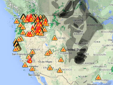
Smoke from western wildfires continues to generate air quality advisories across the west, while the heaviest smoke drifts northeast towards Canada and the midwest.

Smoke map, Aug. 29, 2015
Smoke map, Aug. 29, 2015. AirNow.gov.

The map below shows the active spreading for smoke over the next 24 hours. To see the active map, visit this site. 

Smoke map, Airimpact
Smoke map, Airimpact, Aug. 29, 2015

To see the most current smoke reports on Wildfire Today, visit the articles tagged “smoke” at https://wildfiretoday.com/tag/smoke/