Investigation into the three fatalities in Washington begins

A team that will be investigating the August 19 fatalities of three U.S. Forest Service firefighters on the Twisp River Fire in Washington is being assembled. According to an article at OregonLive they will be using a fairly new protocol that we covered in August of 2014, called the Coordinated Response Protocol, or CRP. The controversial process minimizes traumatic impacts on witnesses, coworkers and others close to the tragedy, but strives to avoid developing causes and conclusions. As we reported last August, Ivan Pupulidy, one of the developers of the CRP, called causes and conclusions “traditional nonsense”.

Aside from the controversial nature of the CRP, OregonLive has a very informative article about the investigation into the Twisp River Fire, and how the team will be organized. Below is an excerpt:

…A team of investigators is arriving Thursday to begin the recently adopted Coordinated Response Protocol. The new rules seek to eliminate missteps on fatal investigations of the past.

“My heart breaks over the loss of life,” Gov. Jay Inslee said in a statement. “They gave their lives to protect others. It was their calling, but the loss for their families is immense.”

Officials often found that people assigned to investigate deaths or serious accidents were so focused on the task at hand they were insensitive to the victims involved during the interview process. The goal is to learn from what happened and take steps to prevent mistakes from happening again.

“It’s a smoother way to help the people involved because they are obviously traumatized,” said Mike Ferris, a spokesman for the National Interagency Fire Center in Boise. Ferris’ colleague, Jennifer Jones, will join the investigation Thursday as the information coordinator.

“It means the people affected by the incident don’t have to sit through 12 interviews by five or six different people,” Ferris said during a phone interview Thursday morning with The Oregonian/OregonLive.

The process were implemented with the July 30 death of David Ruhl, a U.S. Forest Service captain from South Dakota’s Black Hills National Forest. He died in a wildfire in the Modoc National Forest of Northern California.

A learning review replaces the serious accident investigation process with hope to “minimize the impact that reviews can have on the personnel who were involved in the incident while simultaneously meeting organizational and ethical requirements,” according to Forest Service documents.

Officials also hope briefing victims’ families during the new process relieves tensions that occurred in the past.

The goal is to provide “as clear a picture of what influenced actions and decisions as possible” even if it results in “uncovering hard truths that might appear contrary to protecting the agency,” the documents say…

The graphic below (of strangely faceless people) is from the USFS’ description of the CRP process.

CRP team structure

Firefighters from New Zealand and Australia to assist with wildfires in the U.S.

The National Interagency Fire Center in Boise, Idaho is mobilizing firefighters from Australia and New Zealand to assist with wildfire suppression efforts in the western United States. The two countries have been key partners with the U.S. fire community for more than 50 years but were last mobilized in 2008 when heavy fire activity was similar to this year.

The National Multi-Agency Coordinating Group requested 71 fire managers and specialists.  Although final details of the arrangement are still being worked out, the contingent from Australia and New Zealand is expected to arrive in Boise on August 23 for a one-day induction to learn about current fire behavior, fuels, and weather conditions. Upon completion of the orientation, they will be assigned to large fires.

The request includes 15 Division Supervisors; 15 Task Force/Strike Team Leaders; 15 Helicopter Managers; 10 Heavy Equipment Bosses; 10 Safety Officers; 4 Regional Liaison Officers; and two National Liaison Officers.  Fifteen of the total are from New Zealand. Assistance from Australia and New Zealand is a good fit primarily because their fire organizations are very similar to the United States national fire organization in training requirements and structure.

Okanogan Complex continues to expand, pushed by strong winds

(UPDATED at 4 p.m. PT, August 22, 2015)

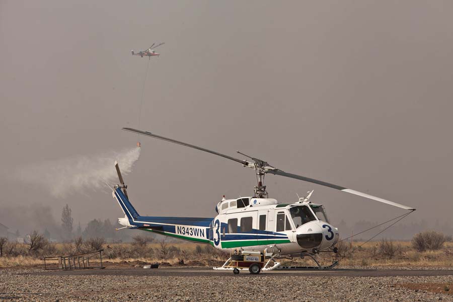
Helicopters at Okanogan Complex of Fires
The arrival of the predicted dry cold front on August 21st, 2015 brought strong winds to the Okanogan Complex of fires and drove part of the blaze into an area near the Okanogan airport where a K-Max helicopter performed bucket work in an area near one of the Washington DNR UH-1 Hueys. Two of the DNR ships joined the K-Max and a civilian Blackhawk in the engagement. Photo by Tom Story.

The Okanogan Complex of fires was very active again on Friday as a cold front with strong winds passed through the area. According Incident Commander Todd Pechota (via Joe O’Sullivan) more than 227,000 acres have burned since the fires started on August 15. Additional evacuation orders were issued as the portion of the fire west of Okanogan spread south and approached and in at least one area crossed Highway 20, which is closed.

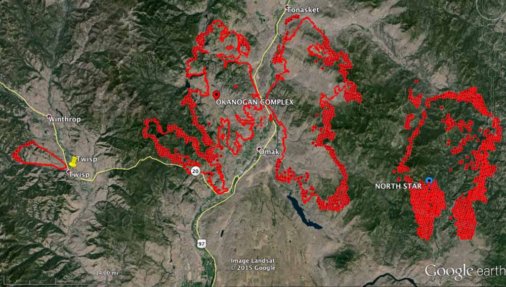
Map Okanogan Fire
Map of the Okanogan Complex of Fires. The fire perimeters shown were mapped at 9 p.m. on August 21. The red dots represent heat detected by a satellite during the 12 hours before 2:22 a.m. on Aug 22, 2015. (click to enlarge)
Washington UH-1 Huey Okanogan Complex of fires
A Washington DNR UH-1 Huey at the Okanogan airport takes off to engage the Okanogan Complex of Fires with some bucket work. Photo by Tom Story.

On Friday, President Obama signed an emergency declaration, ordering federal aid to assist in battling Washington state’s wildfires. The declaration allows FEMA to coordinate disaster relief efforts in Asotin, Chelan, Douglas, Ferry, Klickitat, Okanogan, Pend Orielle, Skamania, Spokane, Stevens, and Yakima counties. It also brings aid to the Colville, Spokane, Kalispel, and Yakima tribes.

For the first time, volunteers are being asked to fight the fires. More than 3,000 people have called and emailed in response to the state’s request for volunteer help with wildfires.

Dino sent us this link to four webcams in the Methow Valley between Twisp and Winthrop, Washington. He said they refresh once an hour. When I checked them Saturday afternoon they were shrouded in smoke.

****

(UPDATE at 9:47 a.m. PT, August 21, 2015)

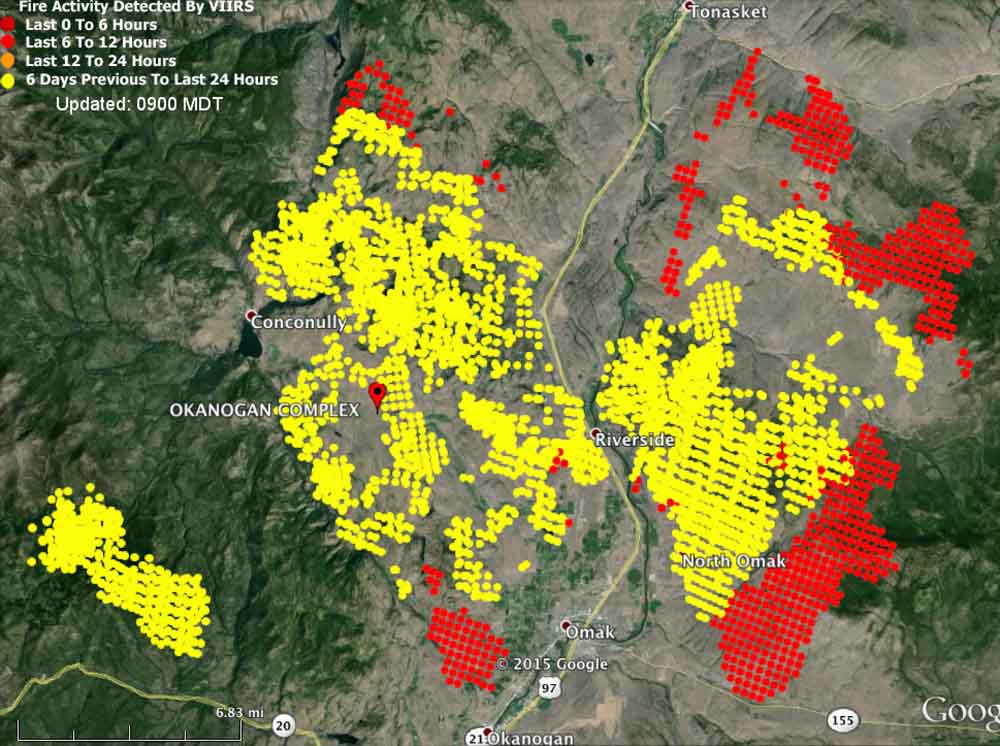
Map Okanogan Fire
Map showing heat detected on the Okanogan Fire by a satellite at 3 a.m. PT August 21, 2015.

The Okanogan Complex of Fires consumed another 40,000 acres of vegetation on Thursday and now covers 124,083 acres, crossing the 100,000-acre threshold to obtain megafire status.

****

(Originally published at 2:58 p.m. PT, August 20, 2015)

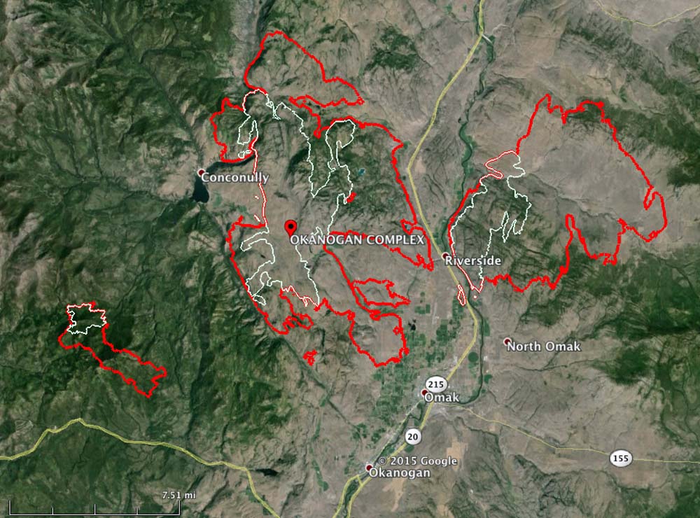
map Okanogan Complex
The red line was the fire perimeter of the Okanogan Complex at 11 p.m. PT August 19, 2015. The white line is from about 24 hours before. (click to enlarge)

The Okanagan Complex, comprised of 11 fires, some of which grew together, quadrupled in size on Wednesday. It added 60,282 acres and as of 11 p.m. Wednesday night it was 83,441 acres and still growing rapidly (see map above). The Twisp River Fire, on which three firefighters were killed Wednesday, was added to the Complex this morning. A Type 1 incident management team will inbrief on Thursday.

The fire is near Omak, Riverside, and Okanagan in north-central Washington.

The area is under a Red Flag Warning through Friday (see map below) for continued warm temperatures, low humidities and strong north winds on Friday that could reach 50 mph — possibly downing power lines that could start new fires.

wildfireRed Flag Warnings, August 20, 2015

Washington Governor and FS Chief discuss the firefighter fatalities

This morning at 11 a.m. PT Washington Governor Jay Inslee and U.S. Forest Service Chief Tom Tidwell conducted a news conference at the fire station in Chelan, Washington. They discussed the general fire situation in the Northwest, and mentioned the three USFS firefighters who were killed near Twisp, Washington the day before, on August 19.

Not enough firefighters available for the 70,000 acres burning in the Twisp, Washington area

Twisp Okanogan Fires
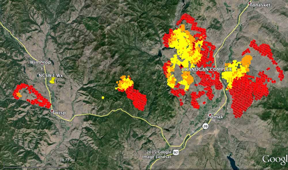
Heat detected by a satellite on the Twisp River and Okanogan Complex Fires at 3 a.m. PT August 20, 2015. The red areas are the most recent. (click to enlarge)

The Twisp River fire that killed the three firefighters and injured four others on Wednesday started earlier that day about six miles northwest of Twisp, Washington. Pushed by a strong northwest wind, it quickly approached the town which was under an evacuation order along with the city of Winthrop. Thursday morning it is listed at 16,000 acres.

As you can see on the map above, that is not the only fire in the area. Within 10 to 40 miles to the east an additional 54,000 acres are on fire. The Okanogan Complex of fires closed in on the community of Riverside north of Omak on Highway 20 Wednesday requiring the complete evacuation of the town. That complex, comprised of at least 10 fires, some of which have merged, is listed at 54,000 acres but could be significantly larger after the fire activity late in the day on Wednesday. Fire managers report that “there is still a shortage of qualified resources”, but that may be partially mitigated since the priority of the incident was recently upgraded.

There are so many fires burning in the west now that there are not enough resources nationwide to suppress them. On some fires very little is being done to slow them down since they don’t have the needed amount of firefighters, incident management teams, caterers, shower units, dozers, fire engines, Type 1 Hotshot crews…. the list goes on.

Part of the problem is that between 2011 and 2015 there was a 17 percent reduction in the number of federal wildland firefighters, according to testimony by Tom Tidwell, Chief of the USFS, in hearings before the Senate Energy and Natural Resources committee.

Today there are 93 uncontained large fires in the United States and 46 incident management teams are assigned. Two area command teams (ACT) are deployed according to the National Situation Report. The ACT page indicates that all three teams are deployed. This year the number of ACTs was reduced from four to three. Right now there is probably a need for six to twelve.

In May, 2015 a spokesperson for the U.S. Forest Service explained the rational for the reduction:

Based on analysis of Area Command Team use over the past 15 years, it was determined that 3 Teams were adequate.

An ACT may be used to oversee the management of large incidents or those to which multiple Incident Management Teams have been assigned. They can take some of the workload off the local administrative unit when they have multiple incidents going at the same time. Your typical Forest or Park is not usually staffed to supervise two or more Incident Management Teams fighting fire in their area. An ACT can provide decision support to Multi-Agency Coordination Groups for allocating scarce resources and help mitigate the span of control for the local Agency Administrator. They also ensure that incidents are properly managed, coordinate team transitions, and evaluate Incident Management Teams.Today there are 593 hand crews and 29,506 total personnel committed to fires.


Firefighters standing by at Twisp as the killer fire approaches

Twisp fire, August 19, 2015The fire that killed three firefighters on Wednesday is still very active and is heading toward the town of Twisp, Washington. The above tweet was sent by KHQ reporter Gabe Cohen at 10 Wednesday night. It sounds like firefighters in the town are going to have their hands full. The entire town and the nearby community of Winthrop are under evacuation orders affecting 3,000 people.

Twisp fire - August 19, 2015

And the weather will not be their friend. Red Flag Warnings are posted for the area through Friday night for strong winds. The chart below (click on it to see a larger version) predicts that Wednesday night the wind at Twisp will be from the northwest at 15 to 17 mph with gusts to 24 mph, pushing the fire closer to the town. It will decrease to 6 to 15 during the day on Thursday and then crank up again Thursday night with gusts up to 22 mph. Friday a cold front will move through but the relative humidity will remain fairly low and the winds will be even stronger, gusting to 28 mph.

Twisp wind and weather