
Since the fire started June 1 about 10 miles north of Durango, CO., it has burned over 34,000 acres west of Highway 550
Continue reading
Since the fire started June 1 about 10 miles north of Durango, CO., it has burned over 34,000 acres west of Highway 550
Continue reading
Above: Accumulated precipitation over the last seven days, June 12-18, 2018.
Moderating weather over the last seven days has helped firefighters make progress on some of the fires in Colorado, Wyoming, New Mexico, and Utah. Today’s national Situation Report showed little or no increase in the size of wildfires in those four states. The 416 Fire in southwest Colorado and the Badger Creek Fire in southern Wyoming released a total of 345 personnel over the last 24 hours.
Todd Pechota’s Type 1 Incident Management Team is currently assigned to the 416 Fire, but Joe Reinarz’s NIMO team has been mobilized for the fire, which could be an indication that they expect it to be a long term incident. The west side of the fire has spread into steep, remote terrain above 8,000 feet as it grows closer to an 11,000 to 12,000-foot ridge five miles away. Much of the ridge is above the timber line and may eventually, with patience over time, serve as a barrier. Mr. Reinarz’s team team will transition on Friday.
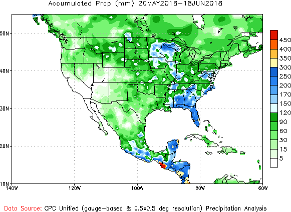
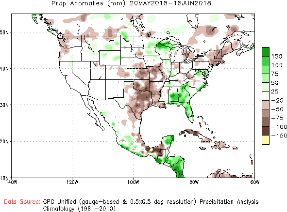
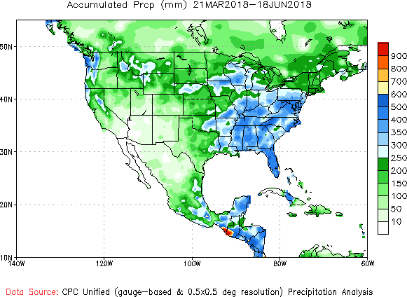
Below, National Weather Service graphics show the observed precipitation and the departure from normal for the last 30 and 90 days.


Above: 3-D map of the Peak 2 Fire, July 7, 2017.
(Originally published at 7 a.m. MDT July 8, 2017)
Residents of the 463 homes in the Peak 7 neighborhood near the Peak 2 Fire north of Breckenridge, Colorado were able to return to their homes Friday night for the first time since the fire started July 5. The fire has burned 74 to 84 acres, about the size of an 18-hole golf course, but no one would ever build a golf course on terrain this steep (see map above).
Todd Pechota’s Type 1 Incident Management Team assumed command at 6 a.m. Friday.
The resources assigned to the fire include 8 hand crews, 15 engines, and 8 helicopters for a total of 362 personnel.
The U.S. Forest Service announced that Todd Pechota, Forest Fire Management Officer (FMO) on the Black Hills National Forest, is the recipient of the 2015 National Forest FMO of the Year award. He received the honor during a recent ceremony at the U.S. Forest Service Regional Office in Colorado.
The Black Hills National forest is in the Black Hills of western South Dakota and northeast Wyoming.

The award recognizes the most outstanding fire manager in the U.S. Forest Service each year. It has a long and prestigious history of honoring fire managers who have exhibited exceptional leadership in Forest Fire Management leadership as a Forest Fire Management Officer.
“Todd is an exceptional leader in wildland fire,” said Craig Bobzien, Black Hills National Forest Supervisor. “This award is a testament to the work he has accomplished. It underscores the relationships he has developed locally and across the nation, and the special care that he has shown for all those that have worked with him.”
In addition to his position as FMO on the Black Hills National Forest, Pechota serves as the Incident Commander for the Rocky Mountain Type 1 Incident Management Team and is past Chairman of the Great Plains Regional Dispatch Board of Directors.
When I heard this morning that the Black Hills National Forest was going to conduct a 94-acre prescribed fire today I looked out my window at the snow in my yard. Curious about how they were going to accomplish this I departed on a expedition to answer this question. It being close to lunch time I stopped at the Dew Drop In for a burger and their wonderful homemade fries, and then again at the TurtleTown chocolate shop for, obviously, a bag of chocolate turtles.
Passing near the Crazy Horse mega-sculpture I saw two bald eagles on the ground in a pasture. I pulled over onto a nearby side road hoping to get a photo, but they were pretty skittish and rudely flew away. But I still grabbed a few not very impressive photos.


By the time I made it to the Whaley prescribed fire near Hill City, South Dakota, I was no longer hungry and was ready to see how the the U.S. Forest Service fire folks were going to pull this off.

It turned out that there was almost no snow on the south facing slopes and they were about 75 percent done with ignition when I pulled up. But there was still snow in some of the flat lands and shaded areas, enough to make it pretty easy to find snow fields, in addition to roads, to serve as control lines.
At the Elk Mountain weather station the temperature was in the 40s, the relative humidity in the low 30s, and the sky was partly cloudy. As it turned out, a good day for being out in the woods with a drip torch.
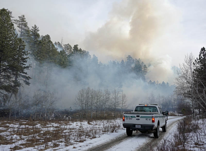
The video at the top of the article includes still photos, video clips, and an interview with Todd Pechota, the Fire Staff Officer for the Black Hills National Forest.
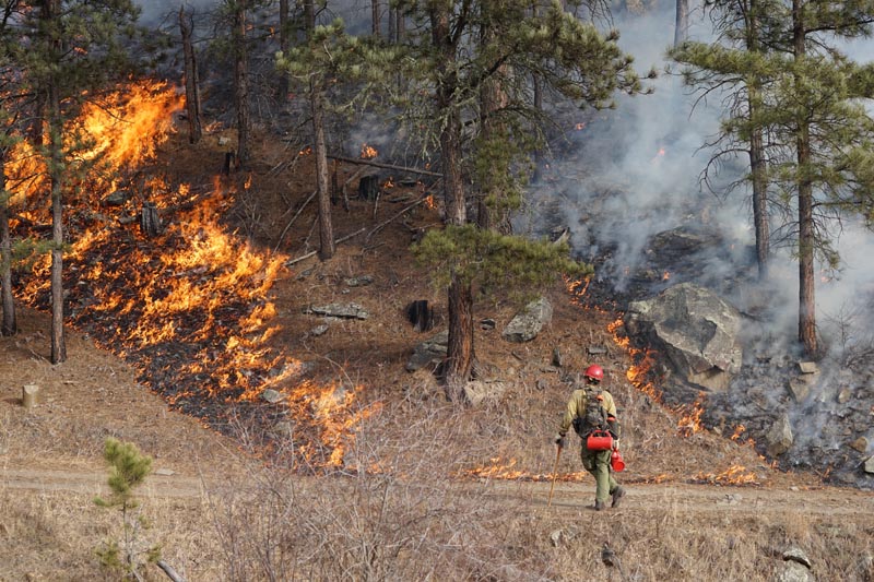
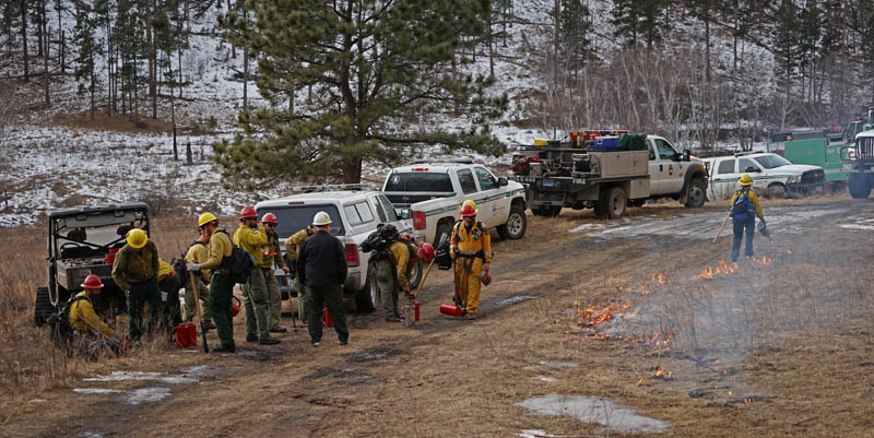
 Fire in the Lake San Antonio area of Monterey County, California, August, 2009. Photo by Vern Fisher.
The following article was contributed by Frank Carroll.
****
Only You…
For the United States Forest Service and the other major federal, state and local wildland fire agencies, the music is playing the band. It worked OK for the Grateful Dead. It’s a different story when it comes to developing and conducting wildland fire policy.
It may surprise no one to discover that wildland fires are bigger, more costly, more damaging, and more out of control than in any decade before the present, all the way back to 1910. There was so much large fire on the ground in the 2015 fire season we ran out of superlatives to describe how big and bad they were. In many cases the fires burned together forming “charismatic megafires” of untold destruction, sometimes because we had no choice.
Author Stephen Pyne, in an often brutally honest book about where we’ve been and where we’re headed with fire management in America, observes that fire is managing us; we’re not managing fire (Between Two Fires 2015).
What began in the late 1960s as a scarcely heard warning siren that wildfire should be left to its own devices on certain wild lands (prescribed natural fire or “let burn” fires pioneered by the National Park Service) became, by 2000, a five alarm screaming wail heard round the world. Our best laid plans have come to naught. We are caught in a blizzard of falling ash, awash in a river of flying embers, and blinded by the smoke. It is clear that no human power will stop the rising tide of flames in wildlands and Red Zone suburbs where 10 percent of our homes are, no matter what the cost.
How we got here is a tale worth reading. Where we’re headed is into the fog of war, but not without guideposts and markers. Based on the very sound idea that fire should play a natural role in natural resource management, agencies and scientists spent the past 50 years trying to work out how to get it done. And they had help. The Nature Conservancy can field its own firefighters and burn its own ground. Environmentalists looked for ways to burn without having to pay for the work of preparing and herding fires, and without the expertise to help. Their grand experiment in the theology/ecology of hope over the last 50 years accelerated the fuels problem. The fuels situation is also exacerbated in places where logging results in activity fuels with resulting backlogs needing treatment and feeding wildfires.

The Rough Fire east of Fresno, after burning for more than a month, will be transitioning from a Type 1 incident management team to a National Incident Management Team (NIMO) from Boise (Reinarz) and a Type 3 team. This new organization “will manage the entire incident”, according to South Zone News and Notes. Pechota’s Type 1 IMT “will be transitioning into command [Friday]” on the south part of the fire, South Zone News and Notes reported on Thursday.
The fire is being staffed by 1,901 personnel and has grown to 81,549 acres. The Team is calling it 25 percent contained.

Below is an excerpt from an update on the fire, provided by the incident management team the evening of September 2, 2015:
****
“The SCSIIMT (Cooper) will be transitioning to a Sierra National Forest Type Three Organization who will be assuming responsibility for the continuing fire suppression and support activities. In addition, a National Incident Management Organization (NIMO) will arrive during this transition.
Fire crews continue to gain ground on the fire in the Crown Valley trailhead area. Containment lines are being established in conjunction with mop up operations along the fire line. Fire suppression repair work is underway on some of the fire affected areas. This work will help with possible soil erosion in case of a water event.
The Wildland Fire Modules are finishing their backfiring operations in the John Muir Wilderness supported by a pack string of mules to limit helicopter flights in the wilderness. In addition, the High Sierra OHV crew continues to support fire personnel with deliveries and removal of hose and tools in difficult terrain.
Weather during the morning and early afternoon prevented firing operations from taking place in the south zone. Crews continued to reinforce lines in the Hoist Ridge and Buck Rock areas in preparation for burn operations tonight, weather permitting.
The fire has continued to push east along the north side of Highway 180. It is currently about two miles from Cedar Grove. Vulnerable structures in this area have been wrapped, and hose lines placed in preparation for the approaching fire. Crews are working to bring the fire north toward Stag Dome in an effort to keep it away from the lodge area.”
****
Related:
(UPDATED at 4 p.m. PT, August 22, 2015)
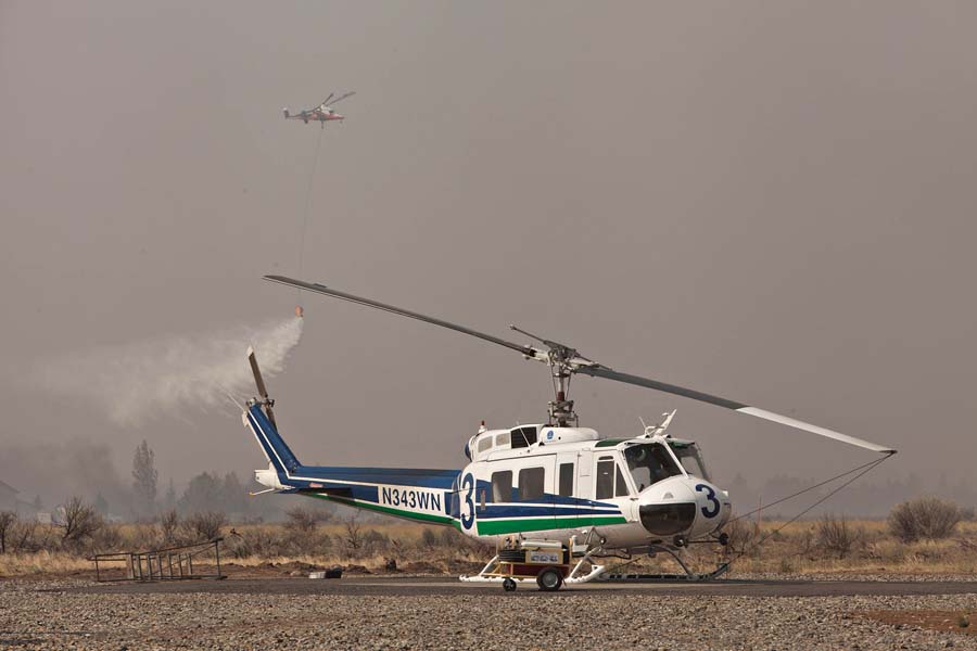
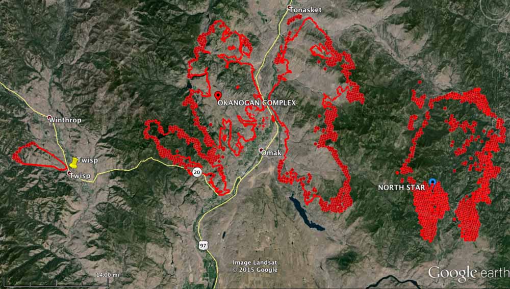
The Okanogan Complex of fires was very active again on Friday as a cold front with strong winds passed through the area. According Incident Commander Todd Pechota (via Joe O’Sullivan) more than 227,000 acres have burned since the fires started on August 15. Additional evacuation orders were issued as the portion of the fire west of Okanogan spread south and approached and in at least one area crossed Highway 20, which is closed.

On Friday, President Obama signed an emergency declaration, ordering federal aid to assist in battling Washington state’s wildfires. The declaration allows FEMA to coordinate disaster relief efforts in Asotin, Chelan, Douglas, Ferry, Klickitat, Okanogan, Pend Orielle, Skamania, Spokane, Stevens, and Yakima counties. It also brings aid to the Colville, Spokane, Kalispel, and Yakima tribes.
For the first time, volunteers are being asked to fight the fires. More than 3,000 people have called and emailed in response to the state’s request for volunteer help with wildfires.
Dino sent us this link to four webcams in the Methow Valley between Twisp and Winthrop, Washington. He said they refresh once an hour. When I checked them Saturday afternoon they were shrouded in smoke.
****
(UPDATE at 9:47 a.m. PT, August 21, 2015)
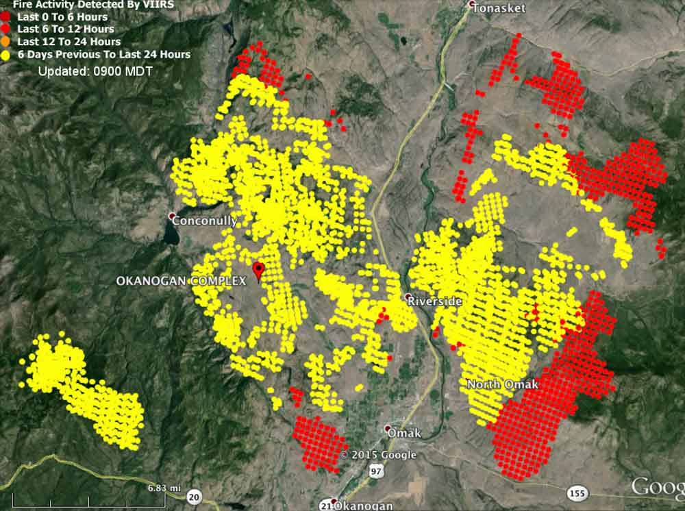
The Okanogan Complex of Fires consumed another 40,000 acres of vegetation on Thursday and now covers 124,083 acres, crossing the 100,000-acre threshold to obtain megafire status.
****
(Originally published at 2:58 p.m. PT, August 20, 2015)
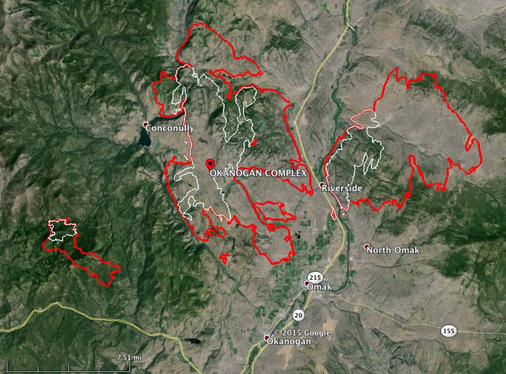
The Okanagan Complex, comprised of 11 fires, some of which grew together, quadrupled in size on Wednesday. It added 60,282 acres and as of 11 p.m. Wednesday night it was 83,441 acres and still growing rapidly (see map above). The Twisp River Fire, on which three firefighters were killed Wednesday, was added to the Complex this morning. A Type 1 incident management team will inbrief on Thursday.
The fire is near Omak, Riverside, and Okanagan in north-central Washington.
The area is under a Red Flag Warning through Friday (see map below) for continued warm temperatures, low humidities and strong north winds on Friday that could reach 50 mph — possibly downing power lines that could start new fires.

(UPDATED at 4:25 p.m. MT, August 18, 2015)
Fire managers are calling the Soda fire southwest of Boise, Idaho, 90 percent contained.
The demobilization process will begin today, August 18, and most firefighting resources will be reassigned to other fires in the west. The remaining crews and engines will continue to patrol, look for any smokes, and assist in the rehabilitation of containment lines.
As the Soda Fire nears 100% containment, a federal Burned Area Emergency Response (BAER) Team is being convened to begin field work as early as Wednesday. The BAER Team of natural resource specialists will assess damage and design emergency stabilization and rehabilitation treatments for BLM lands. This assessment focuses on mitigating threats to life, property, and resources within the burned area over the next 3 years.
The Rocky Mountain Incident Management Team will be transitioning the Soda Fire to a local BLM Type 3 Team at 6am Wednesday, August 19, 2015.
This will be our last update on the Soda Fire unless there is a significant upward change in fire activity.
(Update June 3, 2016: the final size was 279,144 acres.)
****
(UPDATED at 9:18 a.m. MT, August 15, 2015)
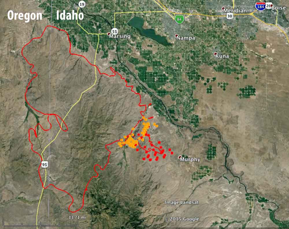
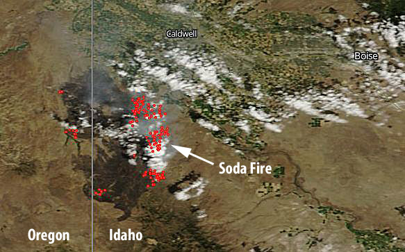
Friday evening the Soda Fire only had one area that with a large amount of fire activity, and that was on the southeast side where the fire was spreading to the southeast in the direction of Murphy, Idaho. This fire is very hard for heat-sensing mapping systems to track because in many areas the vegetation is grass or light brush that ignites, burns up quickly, and may cool off before an infrared aircraft or heat-sensing satellite passes over.
The fire has burned about 265,000 acres.
From InciWeb, August 14, 2015:
The Owyhee County Dispatch issued notification for residents to prepare for evacuations in the Bailey Road, Reynolds Road near feedlot, China Ditch, and Wilson Creek due to extreme fire behavior caused by high winds and terrain that is aligned with the wind. Highway 78 open at this time.
There is limited air support at this time due to the very high winds (30-40 mph). A very large air tanker was used throughout the day in conjunction with crews and dozers to construct containment lines along the Willow and Reynolds Creek areas.
Friday afternoon the wind was gusting at 30 to 43 mph out of the southwest and later the northwest, while the relative humidity got as low as 8 percent at 7 p.m. The forecast on Saturday for the southeast portion of the fire is for 81 degrees, 18 percent RH, mostly sunny skies, and 10 mph winds from the northwest shifting to the north in the afternoon. With the lower wind speeds on Saturday the fire should not spread as quickly as it did Friday afternoon.
****
(UPDATED at 12:36 p.m. MT, August 14, 2015)
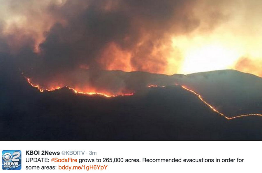
At 2 a.m. on August 14, the Owyhee County Sheriffs office recommended (but did not require) an evacuation near the Soda Fire for the Wilson Creek area south of Hwy 78 at milepost 16 through 18 due to increased fire activity. This area includes the Gibbons Hot Springs and the Hard Trigger Road. The Sheriff is asking people to please be prepared to evacuate. There are no mandatory evacuation orders in place on the Soda Fire.
The blaze is burning grass and sagebrush in Oregon and Idaho 14 miles southwest of Caldwell and 11 miles southwest of Nampa, Idaho (see the map below). The incident management team reports it has now blackened 265,000 acres.
Friday could be a big day on the fire, and dangerous for firefighters. The area is under a Red Flag Warning from noon on Friday until midnight for southwesterly winds reaching 18 to 25 mph with gusts to 35 mph in the afternoon. Friday night the wind will shift to come out of the west and then the northwest. The relative humidity will dip to 10 to 15 percent Friday afternoon.
You can monitor the weather conditions updated once an hour at the Owyhee weather station, 5 miles west of the northern end of the fire. At 11:52 a.m. on Friday it recorded 85 degrees, 14 percent humidity, and southwest winds of 8 mph gusting to 17 mph.
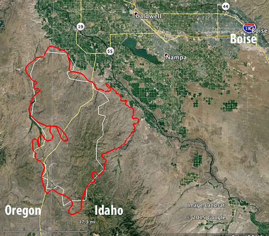
Strong winds Thursday night caused increased fire activity in the Reynolds Creek and Wilson Creek drainages on the southeast flank of the fire. Over 300 additional firefighting resources were put in place to reinforce the line through the night.
The Rocky Mountain Type 1 Incident Management Team led by Incident Commander Todd Pechota will shadow Great Basin Incident Management Team 5 Friday in preparation for assuming command of the southern section of the fire Saturday morning.
****
(UPDATED at 5:50 p.m. MT, August 13, 2015)

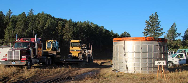
Monday morning we attended the 7 a.m. briefing for the Norbeck Section 2 prescribed fire in the Black Hills. It is a complex, Type 1, 1,938-acre project on State, Federal and private lands approximately 4 miles northeast of Pringle, South Dakota. The 120 personnel will be igniting vegetation in Wind Cave National Park, Custer State park, Black Hills National Forest, and private land. Some of the funding is provided by the Rocky Mountain Elk Foundation. To assist with ignition on the large project a Type 3 helicopter will be dropping plastic spheres that burst into flame about 30 seconds after they exit the dispenser on the helicopter.
When I looked at the large crowd assembled for the briefing and remarked to Todd Pechota, the Fire Management Officer for the Black Hills National Forest, that I didn’t expect to see so many people, he said, “We wanted to get this one right”.

The four different land owners and the funding from a non-government organization are some of the reasons why planning for the project has been going on for at least five years. They brought in a Prescribed Fire Burn Boss, Ross Wilmore the Fire Management Officer on the White River National Forest in Colorado, to work with the trainee Burn Boss, Matt Spring.
And just to make things a little more complicated, the annual buffalo roundup in Wind Cave National Park is occurring now, with the animals being herded to corrals about a half mile east of the prescribed fire. Many people from the national park are tied up on that project.
The ignition of the burn is expected to take two days, Monday and Tuesday of this week. Dew and even frost in some areas may delay the start of the project Monday morning, but things should dry out by mid- to late morning.
Highway 87 through Custer State Park and Wind Cave National Park will be closed Monday through Wednesday. As the fire progresses through the ponderosa pine and grass meadows in the area, it will be putting up a large amount of smoke. The firefighters expect to work from north to south, primarily concentrating on the three northern-most units on Monday, and move to Unit 4 on the south end on Tuesday. (See the map below.)
We will return to the prescribed fire Monday afternoon to report on the progress and hopefully grab some more photos.
(UPDATE: photos taken as the project was underway are here.)

The weather for the project looks pretty good. The spot weather forecast for Monday predicts southwest then south winds at 6 to 10 mph, 72 degrees, and relative humidity of 31 percent; Tuesday looks about the same. The smoke will be pushed toward the north and northeast.