Dry lightning and unstable atmosphere results in Red Flag Warnings

wildfire ed Flag Warnings August 1, 2015

The National Weather Service has issued Red Flag Warnings or Fire Weather Watches for areas in Washington, Oregon, Idaho, California, and Montana. Firefighters in northern California can expect abundant lightning Saturday afternoon, accompanied by little or no rain. In the other Red Flag areas dry and breezy conditions are in the forecast along with an unstable atmosphere and a high Haines Index which could contribute to rapid spread of existing or new fires.

The map was current as of 9 a.m. MDT on Saturday. Red Flag Warnings can change throughout the day as the National Weather Service offices around the country update and revise their forecasts and maps. For the most current data visit this NWS site or this NWS site.

Fire prevention at the Sturgis Motorcycle Rally

Don't Burn the Rally

In case you are not familiar with it, the Sturgis Motorcycle Rally is a big deal. Every year hundreds of thousands of motorcycle enthusiasts descend on Sturgis, South Dakota and the greater Black Hills area in southwest South Dakota and Wyoming. This year an even larger crowd, up to 1.2 million people, is expected since it is the 75th anniversary of the event which will be held August 3 through 9. Every motel within a hundred miles will be booked up, and at rates much higher than you’d pay at other times.

The wildland fire agencies are used to the routine and they usually make special preparations and have representatives designated to be the points of contact with the Rally Operations Center set up by the state Office of Emergency Management.

By Monday, August 3 there will be two single engine air tankers (SEATs) in the area, one each at Hot Springs, SD and at Chadron, NE. Two helicopters, a Type1 and a Type 3 are based at Custer, SD this year, but they have not spent much time there yet since they have been assigned to fires out of the area. The Type 3 will be available locally for the duration of the rally but the Type 1 is on an assignment elsewhere. The Black Hills National Forest has brought in six fire engines from other areas to beef up the local fire suppression capability. Currently there are no air tankers positioned at the Rapid City Air Tanker Base; however, the facility is open and staffed.

A few years ago the local agencies started the “Don’t Burn the Rally” program, in an effort to educate bikers from Ohio and Newfoundland about how not to burn the place down. Thankfully this year due to abundant rain in the spring and early summer the herbaceous vegetation is greener than usual, so it will be a little more difficult to get a large fire going.

I noticed the law enforcement officer on the Harley Davidson motorcycle in the poster above, and that there are no markings visible to identify the agency. I don’t know if they are still doing it, but Harley used to provide several bikes like that to the local National Parks, and possibly other agencies in the Black Hills, so that their law enforcement officers could use them during the rally. Some of the guys who had their own personal bikes loved being able to cruise around on a motorcycle while getting paid for it.

And below, you’ll see that even the weather forecasters in Rapid City are getting into the Rally spirit.

Rally weather forecast

South Dakota firefighter killed while responding to a fire in California

By Ken Sandusky, U.S. Forest Service,
released at 7:45 p.m PT, July 31, 2015

****

“Alturas, Calif. – It is with great sadness we must confirm a Forest Service firefighter lost his life yesterday while responding to the Frog Fire northwest of Adin, California (map). The deceased is David “Dave” Ruhl of Rapid City, South Dakota.

Search and rescue was conducted throughout the night until the firefighter was found this morning.

Dave was on temporary assignment to the Big Valley Ranger District of the Modoc National Forest as an Assistant Fire Management Officer since June 14. Dave’s permanent position is Engine Captain on the Mystic Ranger District of the Black Hills National Forest in Rapid City.

The Forest Service is investigating this line-of-duty death.

“This loss of life is tragic and heartbreaking,” said Forest Supervisor, Amanda McAdams. “Please keep the family and all of our Forest Service employees in your thoughts and prayers during this difficult time.”

The Frog Fire southeast of Lava Camp on the Big Valley Ranger District started yesterday afternoon, exhibiting active fire behavior and growing to more than 800 acres by this evening with active spotting ahead of the fire front.

Northern California Team 1 is expected to take over management of the fire Saturday morning.

Additional detailed information on the Frog Fire will be available on Inciweb at http://inciweb.nwcg.gov/incident/4427/.”

****

California Governor Brown also issued a statement about the fatality and mentioned that Mr. Ruhl is survived by his wife, Erin, and their two children. He worked for the U.S. Forest Service for 14 years and previously served in the U.S. Coast Guard.

In honor of Firefighter Ruhl, California Capitol flags will be flown at half-staff.

At Wildfire Today our sincere condolences go out to Mr. Ruhl’s friends, co-workers, and family.

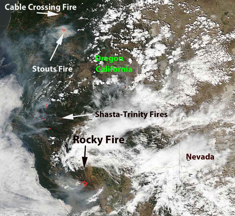
Satellite photo of smoke from west coast fires

smoke west coast wildfires

The photo above shows smoke that is being created by the fires in northern California and southwest Oregon. The red dots represent heat detected by a satellite on the fires. Generally to the west, or left, of the red dots you can see the white smoke being blown to the west. The rest of the white on the image is clouds. Click on the image to see a larger version.

The satellite image was captures in the late afternoon on Friday.

The Rocky Fire is threatening towns northwest of Sacramento, California, including Clearlake, Lower Lake, and Twin Lake.

Dozens of new lightning-caused fires have been detected in the last 24 hours on the Shasta-Trinity National Forest between Redding and Eureka, California in northwest California.

The Stouts Fire 10 miles east of Canyonville, Oregon exploded to 6,500 acres within 12 hours after it started on Thursday.

To see the most current smoke reports on Wildfire Today, visit the articles tagged “smoke” at https://wildfiretoday.com/tag/smoke/

Stouts Fire east of Canyonville, OR forces evacuations

(Originally published at 9:48 a.m. PT, July 31, 2015, updated at 6:12 p.m. PT, July 31, 2015)

Stout Creek and Cable Crossing Fires
Smoke from the Stouts and Cable Crossing Fires, 7-31-2015.
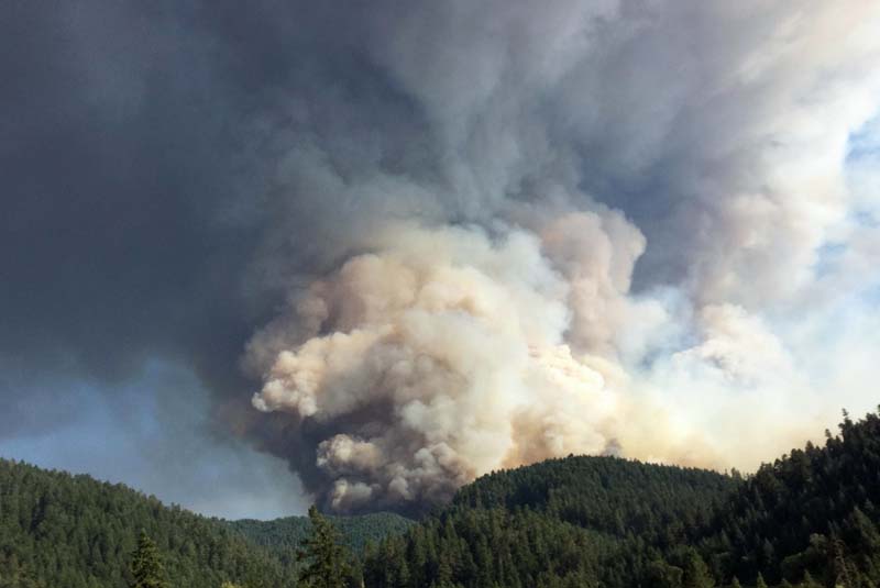
Stouts Fire 7-30-2015
Stouts Fire east of Canyonville, Oregon, July 30, 2015. InciWeb photo.

The Stouts Fire 10 miles east of Canyonville, Oregon exploded to 6,500 acres within 12 hours after it started on Thursday (see maps below).

The fire burned actively late into the night toward the southeast before laying down in the early morning hours. Firefighters Thursday night focused their efforts on opening access roads and anchoring into the heel of the fire to begin constructing fireline.

Approximately 450 firefighters are on scene Friday. Fire activity is expected to increase throughout the day today. The National Weather Service has issued a Red Flag Warning for most of western Oregon.

Thursday night, the Douglas County Sheriff’s Office issued a Level 3 (GO) evacuation notice for homes on Stouts Creek Road, Ferguson Lane, and Conley Lane. A Level 1 (READY) evacuation notice was issued for all homes on Upper Cow Creek, east of Snow Creek Road. A Red Cross Shelter opened at the Canyonville Elementary School, at 124 N. Main Street in Canyonville.

The Oregon Department of Forestry Incident Management Team 1 arrived at the Stouts Fire Friday morning.

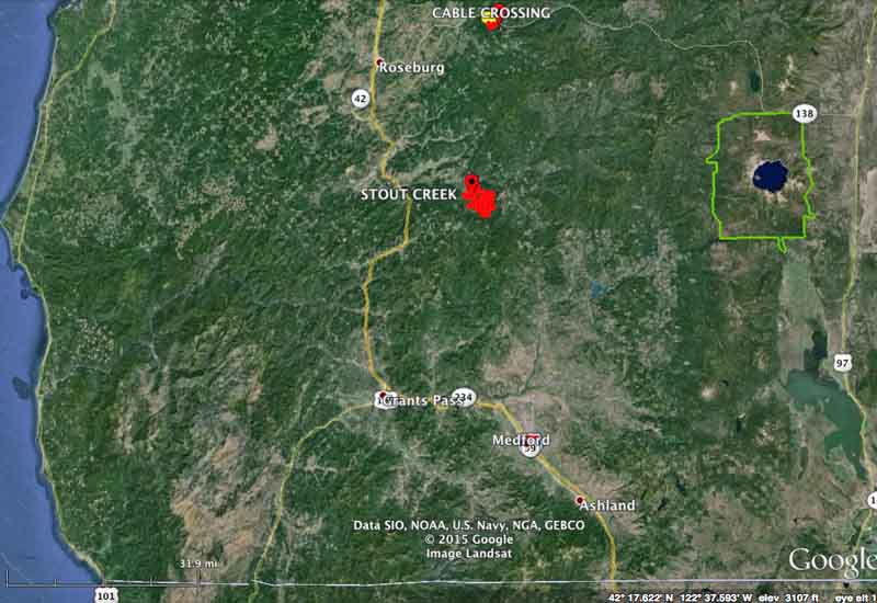
The Stouts Fire is 32 miles northeast of Grants Pass and 24 miles southeast of Roseburg.

Stouts Fire, vicinity map, 7-31-2015
Stouts Fire, vicinity map, July 31, 2015. (The green line is the boundary for Crater Lake National Park.)
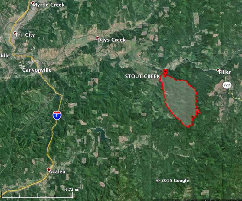
mapStouts Fire
Stouts Fire perimeter map at 1 a.m. PT, July 31, 2015.

Thanks and a tip of the hat go out to JW.

Red Flag Warnings, July 31, 2015

wildfire Red Flag Warnings July 31, 2015

The National Weather Service has issued Red Flag Warnings or Fire Weather Watches for areas in Washington, Oregon, and Montana.

The map was current as of 9 a.m. MDT on Friday. Red Flag Warnings can change throughout the day as the National Weather Service offices around the country update and revise their forecasts and maps. For the most current data visit this NWS site or this NWS site.