1,300 firefighters are working on 35 uncontained bushfires in New South Wales

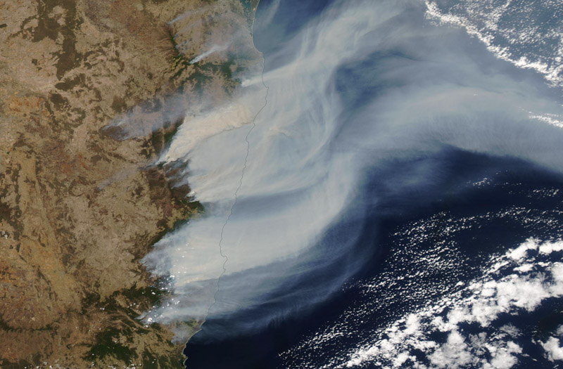
Above: Satellite view of the bushfires in New South Wales, Australia. Impressive zoom of the @CopernicusEU#Sentinel3 OLCI instrument. Via @tonyveco, posted on Twitter November 14, 2019 U.S. time.


So far in this fire season in New South Wales (NSW) Australia, which  officially runs from October 1 to March 31, six people have lost their lives, four in the last week or so. The NSW Rural Fire Service reports that 259 homes have been destroyed in the state since last Friday, but more than 2,100 in the direct path of the fire were saved.

As of early Friday morning local time, more than 1,300 firefighters are working on 35 uncontained bushfires in NSW, with five being at the Watch and Act alert level. The fire danger in the province is elevated on Friday with winds expected to reach 60 to 75 kph.

Late Wednesday night (U.S. Time) Air Tanker 911, a DC-10, was over the Pacific Ocean on the way to Australia when it had to return to its base in Albuquerque due to a problem with a radio. About 50 minutes after departing from San Bernardino the pilots discovered that the High Frequency radio used on long range international flights was not working, even though it appeared to have passed earlier tests on the ground. There had been no need for the HF radio on T-911 since its last international assignment approximately seven years ago. The radio was repaired by connecting the antenna cable and the new ETA at RAAF Richmond in New South Wales is Saturday morning, local time. (more information at FireAviation.com)

Due to fire conditions NSW Premier says “Stay away from bush lands tomorrow”

Fire danger in New South Wales predicted for Nov. 12 is being described by officials as “horrendous” and “catastrophic”

UPDATED at 1:31 p.m. PST November 11, 2019


5:47 p.m. PST November 10, 2019

Satellite photo smoke bush fires New South Wales
Satellite photo shows smoke from bush fires in New South Wales. Processed by Dakota Smith (Approximate date Nov. 8, 2019)

New South Wales has been experiencing hot, dry weather for several days, resulting in numerous bushfires that have burned more than 100 homes. On Monday November 11 local time there were 65 active fires in NSW with about half of those being uncontained, while 10 have risen to the “Watch and Act” alert level.

“We are in uncharted territory,” said NSW Rural Fire Service Commissioner Shane Fitzsimmons. “We have never seen this many fires concurrently at emergency warning level.”

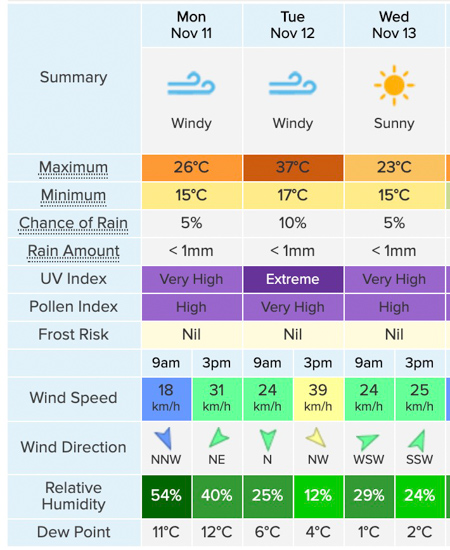
Weather forecast for Sydney, NSW
Weather forecast for Sydney, NSW, created Nov. 11, 2019 local time. Weatherzone. On Tuesday at 3 pm:  98F degrees, 24 mph winds, and relative humidity in the low teens.

Conditions are going to get even worse. The weather forecast for Tuesday, November 12 predicts fire danger that according to the NSW Rural Fire Service will be at the “catastrophic” level. Residents in some areas are being advised to evacuate before the extreme conditions hit even if there are no fires nearby.

On January 8, 2013 the bush fire danger in NSW ranged from Severe to Catastrophic, and  reached the Catastrophic level in Queensland November 28, 2018.

Many of the currently active fires are across the north coast and northern NSW areas and will not be contained by the time the extreme fire weather strikes on Tuesday. Under these conditions, the fires will spread quickly, threatening homes and lives. The fire danger will be as bad, if not worse, than that experienced on Friday as it will be across a much broader area including large population centers like Sydney.

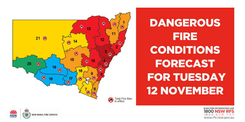
New South Wales bushfire danger November 12, 2019
New South Wales bushfire danger for November 12, 2019. NSW RFS.

At a Monday press conference Premier Gladys Berejiklian said, “Stay away from bush lands tomorrow”. Due to the dangerous fire risk and extreme conditions she said she had declared a state of emergency. It is the first state of emergency in NSW since October, 2013, when major bushfires swept the state during similar weather conditions.

Rural Fire Service Commissioner Shane Fitzsimmons
Rural Fire Service Commissioner Shane Fitzsimmons at the Monday press conference.

“Tomorrow we are facing horrendous conditions, life is at risk when it comes to catastrophic conditions,” said Rural Fire Service Commissioner Shane Fitzsimmons at the press conference. “We cannot guarantee a fire truck at every home. We cannot guarantee an aircraft will be overhead when a fire is impacting on your property. We cannot guarantee that someone will knock on your door and give you a warning that there’s fires nearby. And we certainly cannot guarantee that despite our best efforts the technological tools available will deliver you a message in time.

“We know the fires on the north coast are not going to be contained ahead of [Tuesday’s] weather which means those fires are going to spread, they are going to spread quickly, and they are going to spread aggressively,” the Commissioner continued. “The risk is real to pretty much any community in or around the proximity of all those fires burning on the north areas of New South Wales particularly given the forecast of hot temperatures and dry winds dominating out of the west or northwesterly areas. You can pretty much guarantee anybody to the east or southeast as a predominant pattern will certainly be at risk from the fires on the north coast tomorrow.”

100 homes destroyed in New South Wales bush fires

Above: The Suomi Joint Polar Satellite System captured this photo of smoke from bush fires in New South Wales, Australia, November 8, 2019. The red areas represent heat.

Large, rapidly spreading bushfires that swept through areas in Australia Friday are being described as “unprecedented”. Saturday morning, local time, the New South Wales Rural Fire Service  (NSW RFS) said at least 100 homes have recently burned in 42 fires that are still uncontained across the state. More than 30 people have been injured.

Saturday morning the NWS RFS said, “Fire activity has eased across some firegrounds. Nine fires are now at Emergency Warning and nine are at Watch and Act. We are still seeing erratic and dangerous fire behaviour across the remainder of fire grounds, which continues to pose a threat to homes.”

Queensland is also experiencing fires. Evacuation notices were issued Friday night for Lower Beechmont in the Gold Coast hinterland, Noosa North, and Thornton, west of Brisbane.

Firefighters gaining containment on the Ranch Fire

The fire has burned 2,534 acres 21 miles southwest of Red Bluff, Calif.

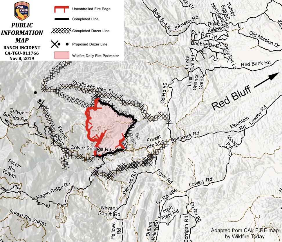
Map of the Ranch Fire November 8, 2019
Map of the Ranch Fire November 8, 2019. CAL FIRE map cropped by Wildfire Today.

10:58 a.m. PST November 8, 2019

Firefighters working on the Ranch Fire have completed a control line around almost half of the perimeter (see map above). Satellites have not detected very many large sources of heat on the western three-quarters of the incident for a couple of days.

The fire is 21 miles southwest of Red Bluff, California and one mile east of the Mendocino National Forest.

Evacuations are still in effect along Colyear Springs Road from Red Bank Road to the Mendocino National Forest Boundary.

CAL FIRE reports that the fire has burned 2,534 acres, which is a reduction from 3,768 acres due to more accurate mapping.

(To see all of the articles on Wildfire Today about the Ranch Fire, including the most recent, click here.)

Resources assigned to the fire include 65 fire engines, 10 water tenders, 36 hand crews, 5 helicopters, and 13 dozers for a total of 1,123 personnel.

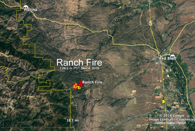
The Ranch Fire burns hundreds of acres southwest of Red Bluff, Calif.

Ranch Fire map
Map showing heat detected by a satellite on the Ranch Fire at 1:06 p.m. PDT Nov. 4, 2019.

UPDATED at 6:42 p.m. PDT Nov. 4, 2019

CAL FIRE reported Monday at 6:25 p.m. that the Ranch Fire 21 miles southwest of Red Bluff, California has burned 1,308 acres. Early Monday morning it was 550 acres.

(To see all of the articles on Wildfire Today about the Ranch Fire, including the most recent, click here.)

The fire was very active Monday afternoon as firefighters on the ground were assisted by numerous air tankers and helicopters.

The fire was originally reported at Colyer Springs Road and Raglin Ridge Road in Tehama County.

The weather forecast for the fire area on Tuesday calls for moderate fire weather; 77 degrees, relative humidity of 20 percent, and winds from variable directions at 6 mph. Early in the morning the wind will be out of the northwest but will shift throughout the day, becoming southeast by sunset. Similar conditions are expected on Wednesday except the wind will be 6 to 10 mph out of the north after 9 a.m.

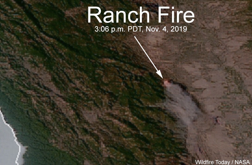
Ranch Fire map satellite photo
Sensors on the GOES-17 satellite detected heat and smoke from the Ranch Fire at 3:06 p.m. PDT Nov. 4, 2019.

Continue reading “The Ranch Fire burns hundreds of acres southwest of Red Bluff, Calif.”

Wrapping up the 77,000-acre Kincade Fire

The fire has burned 77,758 acres north of Santa Rosa, California

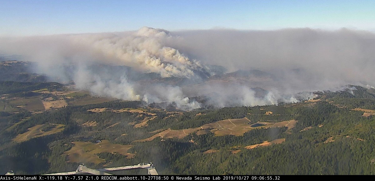
Kincade Fire 9:06 a.m. PDT Oct. 27, 2019
The Kincade Fire as seen from the St. Helena North camera at 9:06 a.m. PDT Oct. 27, 2019. Looking toward Healdsburg.

The Kincade Fire that raced across 77,758 acres north of Santa Rosa, California is not completely out and will not be for weeks or months, but there has not been any major spread for days. Satellites that can detect large areas of heat have not found any since November 1, but firefighters are still mopping up, extinguishing Black Oak stumps that the satellites can’t see, and are putting in fireline where needed. They will also need to repair miles of dozer line that helped keep the fire in check.

CAL FIRE reports that 175 homes, 11 commercial structures, and 186 other buildings have been destroyed.

All evacuation orders have been lifted except for three locations: Briggs Ranch Road area, Highway 128 North Knights Valley area to the Napa County Line, and The Chalk Hill Road area. (more information)

Resources assigned to the fire include 356 engines, 45 water tenders, 3 helicopters, 95 hand crews and 28 dozers for a total of 3,929 personnel.

The Press Democrat is not a huge media outlet, but the staff does a great job of covering wildfires in California’s North Bay. A November 1 article that summarizes the evolution of the Kincade Fire since it started on October 23 is evidence of why citizens should support local news and other original reporting. Their in-depth story has excellent photos and graphics as well as details you will not find other places.