Strong winds are causing the Eastland Complex of fires to spread rapidly
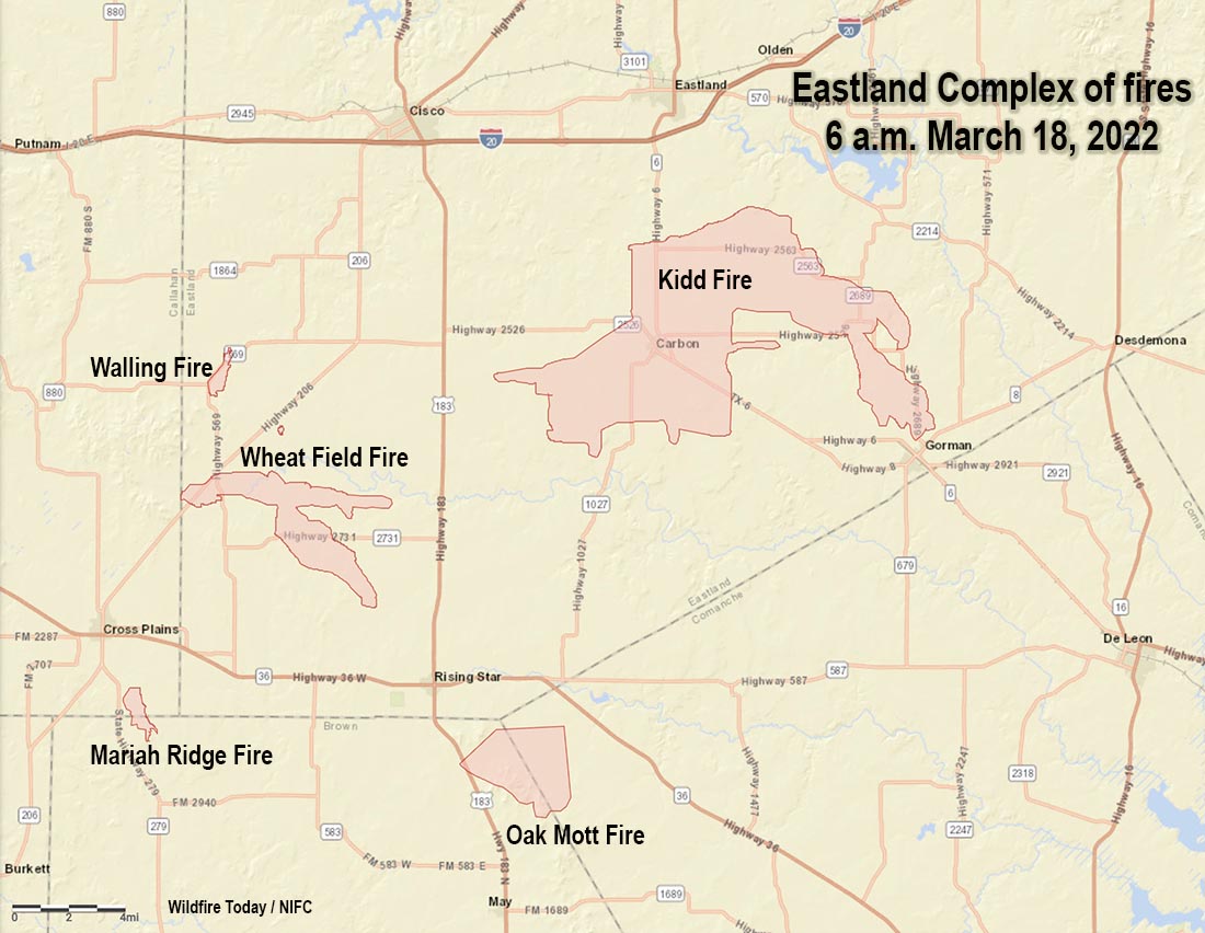
Map of Eastland Complex of fires in Texas at 6 a.m. March 18, 2022.
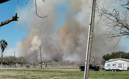
Dry, windy weather has created conditions in West Texas that has allowed multiple wildfires to spread across tens of thousands of acres. Several of the largest blazes are in Eastland County 45 miles east-southeast of Abilene. The passage of a cold front Thursday afternoon caused the fires to spread to the southeast as 15 to 25 mph winds recorded at a weather station near Eastland began gusting out of the northwest at 28 to 35 mph while the relative humidity dropped as low as 7 percent.
For management purposes the Texas Forest Service has grouped four of the incidents into what they are calling the Eastland Complex which has burned approximately 45,000 acres.
Eastland Complex of fires, near Carbon, Texas March 17, 2022. Texas Forest Service photo by M. Leathers.
The 36,000-acre Kidd Fire south of Eastland burned through Carbon March 17, heavily impacting structures. Evacuations and road closures are in effect in Carbon, Lake Leon, Gorman, and outlying rural areas.
The Wheatfield Fire northeast of Cross Plains has burned about 5,000 acres. Thursday it started moving in the direction of Rising Star after the passage of the cold front, but crews were able to stop its forward progression.
The Oak Mott Fire has blackened approximately 5,000 acres southwest of Rising Star.
The Walling Fire northeast of Cross Plains was mapped at 382 acres and is nearly officially contained.
A fire not in the Complex is the 586-acre Mariah Ridge Fire south of Cross Plains.
The weather forecast indicates conditions suitable for continued fire spread. On Friday the northwest winds will continue at 21 mph gusting in the 30s, but slowing to 8 mph by sundown and dropping to 2 to 5 mph Friday night. The Friday afternoon relative humidity will be in the low 20s with a high temperature of 63. On Saturday firefighters can expect a wind shift out of the southwest and south at 9 to 11 mph gusting around 20 with 75 degrees and 16 percent RH.
Multiple highway closures are in effect due to extreme fire behavior. See DriveTexas.org for the latest in closure information.
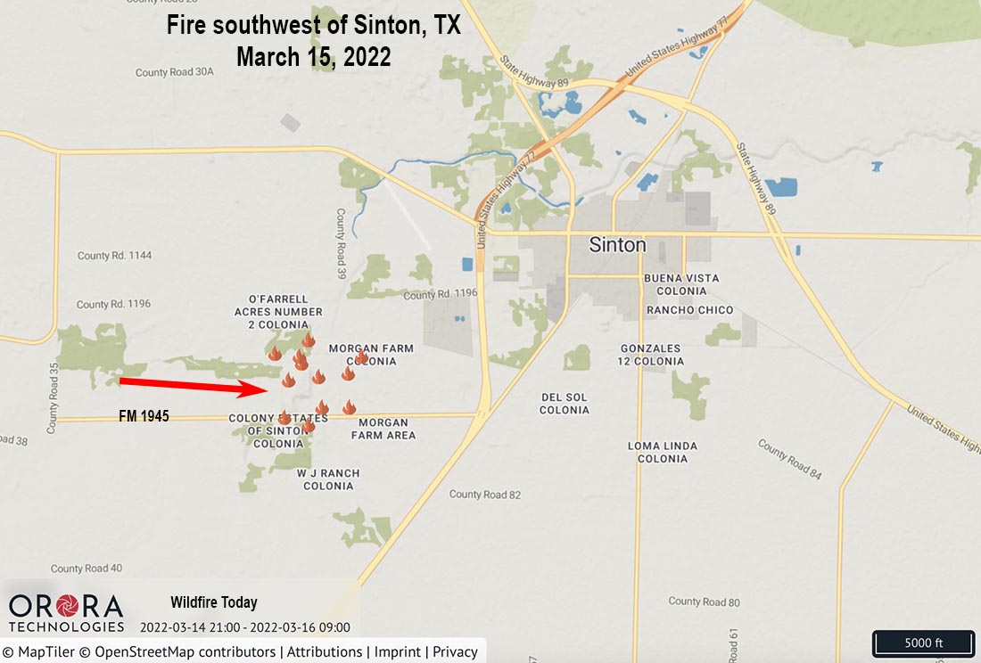
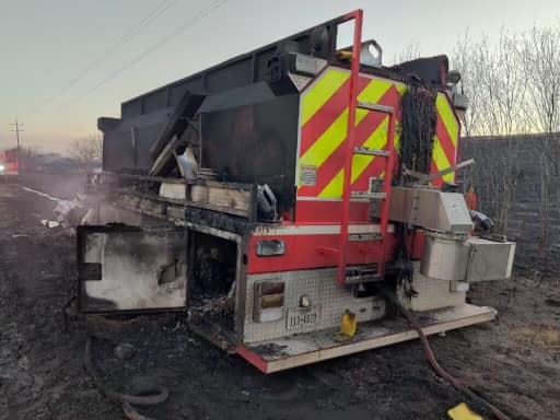
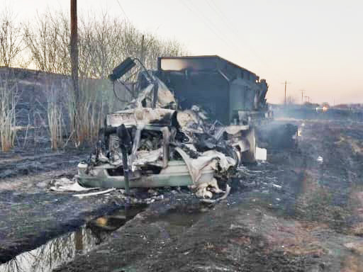
Two firefighters and two local residents were injured at a grass fire Tuesday afternoon southwest of Sinton, Texas. The firefighters were taken by helicopter to hospitals in Corpus Christi and San Antonio.
The blaze burned 385 acres off FM 1945 west of Love’s Truck Stop.
Sinton FD engine. Photo courtesy of Oscar Rivera, San Patricio County Sheriff. March 15, 2022.
San Patricio County Sheriff Oscar Rivera said, “The crew was trapped in the blaze and their fire truck burned to the ground.”
Sinton FD engine. Photo courtesy of Oscar Rivera, San Patricio County Sheriff. March 15, 2022.Sinton, Texas fire. Photo courtesy of Oscar Rivera, San Patricio County Sheriff. March 15, 2022.
At 3 p.m. on Tuesday a weather station near Mathis recorded 85 degrees, 37 percent relative humidity, and 9 mph winds gusting out of the south at 24 mph.
Fire Marshall Steven Loving said another fire in the area was started by a lawnmower as a resident was mowing his yard.
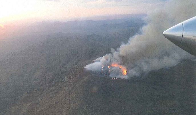
All but one member of the Granite Mountain Hotshots were killed on the Yarnell Hill Fire in 2013
Yarnell Hill fire at 7:30 p.m. MST, June 29, 2013, approximately 21 hours before the 19 fatalities. Photo by ATGS Rory Collins.
Researchers at Embry-Riddle Aeronautical University have published the results of their work which show that winds out of a thunderstorm affected the Yarnell Hill Fire. On June 30, 2013 at about 4:45 p.m. local time 19 members of the Granite Mountain Hotshots were killed as the fire changed direction and overran their position.
The weather that led to the fatalities has been clear since we covered it on Wildfire Today about three hours after the burnover before the entrapment was officially confirmed:
…This was apparently caused by a 180-degree shift in the direction of the wind. From 10 a.m. until 4 p.m. local time at the Stanton RAWS weather station four miles south of the fire, the wind was from the south-southwest or southwest, but at 5 p.m. it began blowing from the north-northeast at 22 to 26 mph gusting up to 43 mph. This may have pushed the fire into the town.
If there were any firefighters on the south or southwest side of the fire between 4 and 5 p.m., who previously had the wind at their backs for seven hours with the fire moving away from them, they may have suddenly and unexpectedly found the fire heading toward them at a rapid rate. Wind direction changes like this are sometimes caused by a passing thunderstorm with strong outflowing downdrafts.
And a few minutes later:
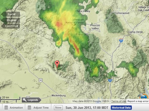
Radar at 4 p.m. MST, June 30, 2013 The pointer is at Yarnell, Arizona. WeatherUnderground.
The radar map above from WeatherUnderground shows a thunderstorm cell north and northeast of the fire at Yarnell, Arizona. The pointer is at Yarnell. The cell was moving toward the southwest, and may have produced strong winds that changed the wind direction by 180 degrees and could have been part of the reason the fire moved into Yarnell. It also could have caught firefighters by surprise.
In 2014 an animation of the weather event was developed by Janice Coen, Ph.D., a Project Scientist at the National Center for Atmospheric Research in Boulder, Colorado. It simulates through a coupled weather-wildland fire environment model the spread of the Yarnell Hill Fire and the wind direction and speed. The arrows indicate the wind direction; the length of the arrows varies with the wind speed.
Below is a summary written by Ginger Pinholster, of the recent research conducted at Embry-Riddle Aeronautical University about the event.
Nineteen firefighters who lost their lives in Arizona’s 2013 Yarnell Hill fire were likely victims of the same meteorological event that caused a deadly 1985 airplane crash, Embry-Riddle Aeronautical University researchers have reported.
City of Prescott firefighters who were members of the Granite Mountain Hotshots were probably surprised by a sudden microburst during the Yarnell Hill fire, according to Embry-Riddle meteorologists Curtis N. James and Michael Kaplan.
A microburst, and the wind shear induced by it, was also what sent a commercial airliner careening off the runway at Dallas/Fort Worth International Airport, killing 137 people on Aug. 2, 1985. That accident prompted major improvements in aviation safety. The National Transportation Safety Board concluded that there had been no way for the L-1011 aircraft to detect microbursts and wind changes. In response, NASA researchers developed new warning technology, and the U.S. Federal Aviation Administration required all commercial aircraft to have on-board wind shear detection systems.
Firefighters do not yet have equivalent protections.
Although microbursts can be detected by Doppler weather radar scanning right above the ground, radar signals are blocked over mountainous terrain or in remote areas where wildfires occur. With funding from the National Science Foundation, James and Kaplan have been collaborating with researchers and graduate students at North Carolina A&T University as well as the National Weather Service to better understand and learn from the tragedy of the Yarnell Hill fire.
On June 30, 2013, “Firefighters knew about the squall line over the Bradshaw Mountains and its outflow moving toward Yarnell,” said James, professor of Meteorology on Embry-Riddle’s Prescott Campus. “What they weren’t anticipating was that a storm cell would develop and create a microburst just to the east of Yarnell. We think the outflow from that microburst rushed westward toward the fire, which then redirected the fire’s motion.”
Microbursts can form very quickly around the periphery of larger, previously identified storms, explained Kaplan, an Embry-Riddle adjunct faculty member and professor emeritus with the Desert Research Institute. “When they hit the ground, microbursts barrel outward, often at high speeds,” added Kaplan, who worked on a team that studied the 1985 crash of Delta Air Lines Flight 191 in Texas.
The Yarnell Hill fire, ignited by lightning amid a drought and extreme summer temperatures, turned in response to the microburst outflow. The fire then rapidly and unexpectedly advanced on the firefighters as they were trying to make their way to safety through a ravine, James said. Analysis of historical meteorological data showed that wind on the north side of the fire, at the Emergency Operations Center, was moving from the north-northeast at 13 miles per hour (mph), whereas in Stanton, southeast of the fire, the wind was gusting to 47 mph.
“It was a very different situation on the south side versus the north side of the fire,” James noted. “Fine-scale convective storm cells can create that type of variability in the wind. That’s something the firefighters weren’t anticipating.”
Staying Safe on the Front Lines
First responders should have access to more information about microbursts, the Embry-Riddle researchers said. Even as an initial thunderstorm may seem to be waning, “It may spawn new storm cells that are extremely focused and intense, and incredibly small sometimes, yet they can wreak havoc,” Kaplan said.
To help raise awareness of the risks of microbursts, James and Kaplan recently shared their findings at the Annual Meeting of the American Meteorological Society. The work has also been published by the journal Climate and the journal Atmosphere.
The next step for the research, Kaplan said, is to run higher-resolution model simulations coupled with a fire behavior model. If all goes well, this “forensic meteorology” approach will show the motion of the fire as it moved through the complex terrain toward the firefighters at Yarnell Hill. At a resolution of 50 meters, “That would get us pretty close to the scale of what the firefighters actually saw that day,” Kaplan said. “That’s our goal.”
In addition to James and Kaplan, the research team includes Mark R. Sinclair, of Embry-Riddle; North Carolina A&T State University researcher Yuh-Lang Lin and his graduate students; and Andrew A. Taylor of the National Weather Service. The research involved the use of the Cheyenne supercomputer at the National Center for Atmospheric Research and is funded by the National Science Foundation.
Tuesday morning at 11:13 Captain Daniel Bertucelli of the Santa Barbara County Fire Department said the Hollister Fire 32 miles west of Santa Barbara, California was still 100 acres. About 175 personnel are assigned and aircraft are available if needed. Crews are reinforcing fire lines in areas inaccessible to dozers.
All evacuation warnings and orders have been lifted.
10:04 a.m. PDT March 13, 2022
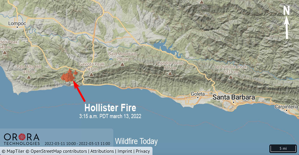
Map showing the location of the Hollister Fire at 3:15 a.m. PDT March 13, 2022.
A wildfire 32 miles west of Santa Barbara, California has prompted evacuations in the Gaviota area. In an update Sunday morning at 7:37 Captain Daniel Bertucelli of the Santa Barbara County Fire Department said it had burned 100 acres and aircraft would be available to assist the firefighters. Dozers were used Saturday to construct fireline.
The blaze was reported at 11:35 a.m. on Saturday near Hollister Ranch Road and Del Norte Road, southwest of Solvang. It is near Gaviota State Park within a mile of the Pacific Ocean, west of Highway 101 and south of Highway 1.
At 10 a.m. Sunday Captain Bertucelli said the evacuation order would go from an order to a warning at noon today.
Hollister Fire. Image by Santa Barbara FD, Daniel Bertucelli, March 12, 2022.
The winds have been very strong in the area. Saturday afternoon the Gaviota weather station recorded 8 to 30 mph winds gusting to 60 mph from various directions. Saturday night the direction became consistent out of the north, as did the speed, 30 to 36 mph gusting up to 60 mph. The relative humidity rose from 20 percent in the afternoon to 91 percent at 8 a.m. Sunday. Overnight cameras showed a marine layer moving into the fire area.
The spot weather forecast is for clear skies on Sunday, 69 degrees, RH of 35 to 40 percent, with ridgetop winds out of the northwest at 20 to 30 mph gusting to 40 mph.
Fire Behavior on Hollister Fire. This fire behavior is not typical of a fire in March. Please be fire aware and limit opportunities for fires to start. For more info on wildfire preparedness go to https://t.co/EhDNA9KZp7pic.twitter.com/zf2M1o8ntE
One of the fires has burned more than 57,000 acres
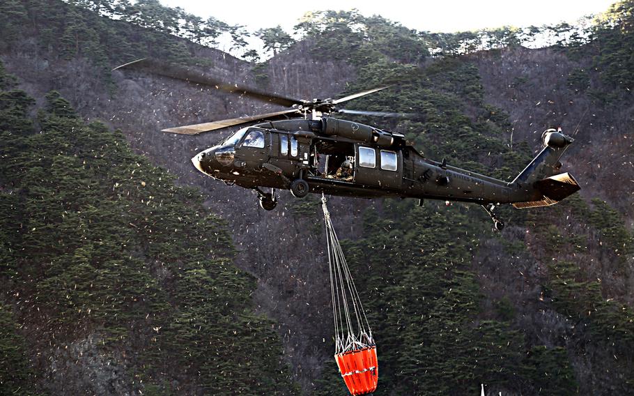
File photo of a UH-60 Black Hawk helicopter from the U.S. 2nd Infantry Division using a Bambi Bucket to drop water on a wildfire in Gangwon province, South Korea, April 5, 2019. (South Korean Army)
The U.S. Army has mobilized helicopters and crews to help suppress wildfires in eastern South Korea following a formal request from their government.
The Army’s 2nd Infantry Division will send UH-60 Black Hawk and CH-47 Chinook helicopters, according to Stars and Stripes. Approximately five helicopters are expected to be deployed.
Map showing the location of heat detected by satellites on wildfires in eastern South Korea, at 5:33 a.m. PST March 12, 2022.
South Korea has been battling several wildfires since March 4. The blaze the 2nd Combat Aviation Brigade will assist in controlling began in Uljin County and had burned nearly 57,400 acres as of Thursday afternoon, according to a Ministry of the Interior and Safety official speaking on condition of anonymity, which is customary in South Korea.
South Korea is not inexperienced in aerial firefighting. The Korea Forest Service (KFS) has at least six S-64 Air-Crane helicopters. In 2001, KFS became the first foreign government to purchase S-64 helicopters from Erickson. The most recently delivered versions have composite main rotor blades and glass cockpits. Some of the S-64 helicopters in the KFS fleet have the optional front-mounted water cannon.
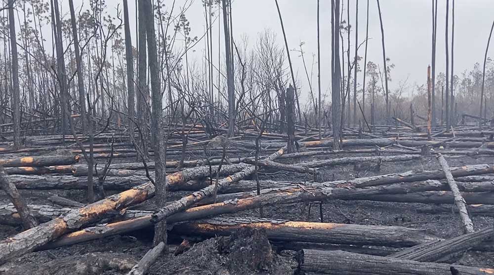
The Bertha Swamp Road Fire in Florida has burned more than 33,000 acres
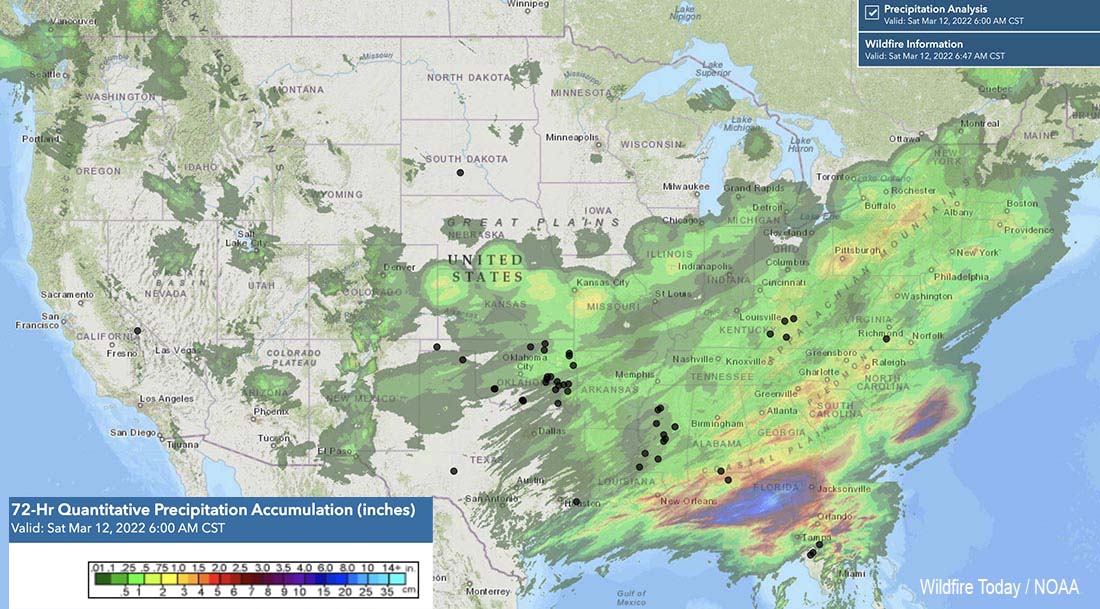
Precipitation accumulated in the 72-hour period ending at 6 p.m. March 12, 2022. The black dots represent wildfires March 12, 2022.
After a week of very busy wildfire activity across the Southern Geographic Area, rain and snow have reduced, at least temporarily, the spread of most of the blazes.
The National Interagency Incident Management Situation Report is only issued once a week about six months of the year because there are fewer large fires in the 11 western states during the fall, winter, and spring. This is the National Interagency Coordination Center’s policy “unless significant activity occurs.”
For the 7-day period that ended Thursday night the weekly Sit Report issued Friday morning listed 60 wildfires in the Southern Area that were larger than 100 acres. Those fires covered portions of three pages. The largest was the Chipola Complex that totaled 34,203 acres (and prompted evacuations). Another 10 exceeded 1,000 acres.
In the Situation Report below, scroll down to see the 60 fires in the Southern Geographic Area.
[pdf-embedder url=”https://wildfiretoday.com/wp-content/uploads/2022/03/Sit-Report-March-11-2022.pdf” title=”Sit Report March 11, 2022″]
Chipola Complex of fires
The map above shows precipitation that accumulated over the 72-hour period that ended Saturday March 12 at 6 a.m. CST. A weather station at Panama City just west of the Chipola Complex measured 0.76 inch of rain since March 9. That will be enough to slow the spread of the 33,131-acre Bertha Swamp Road Fire and help the Florida Forest Service (FFS) complete a fireline around it, but some of the heavy fuels left after the passage of Hurricane Michael could continue burning within the interior.
Bertha Swamp Road Fire, March 11, 2022. Florida Forest Service image.
The Blue Incident Management Team has started transitioning the incident back to the FFS Chipola Forestry Center.
The other two fires in the Complex are the Adkins Avenue (875 acres) and the Star Avenue (197 acres). There has not been much activity on those fires for several days.
The agency reports that Hurricane Michael destroyed 2.8 million acres of trees in the Panhandle and said much of the debris remains on the ground, and will be ready to burn after a few days of dry weather.