Firefighters on Caldor Fire concentrating on dozers and firing operations

It has burned more than 136,000 acres 12 miles southwest of Lake Tahoe

7:51 a.m. PDT August 26, 2021

Map of the Caldor Fire 1223 a.m. August 26, 2021
Map of the Caldor Fire. The pink line was the perimeter mapped by a fixed wing aircraft at 12:23 a.m. PDT August 26, 2021. The blue line was the perimeter 50 hours earlier. The pink shaded areas had extreme heat during the mapping flight.

The northeast side of the 136,000-acre Caldor Fire 12 miles southwest of Lake Tahoe was active Wednesday night. The fire added about 10,000 acres over the last 24 hours. The spot fire north of Highway 50 has continued to spread east, growing to approximately 2,600 acres. The photo below was taken in that area.

To see all articles on Wildfire Today about the Caldor Fire, including the most recent, click HERE.

Caldor Fire, Wrights Lake Rd
Caldor Fire, Wrights Lake Road north of Hwy. 50, Aug. 25, 2021. CAL FIRE photo.

The weather forecast for Thursday predicts 7 to 8 mph winds out of the southwest and northwest with relative humidity in the teens. Friday will be about the same but with lower humidity. These conditions will allow the fire to keep spreading.

Resources assigned as of Wednesday evening included 243 fire engines, 27 water tenders, 21 helicopters, 80 hand crews, and 51 dozers for a total of 2,897 personnel.


Caldor Fire Google 3-D lookin northeast at 1255 p.m. PDT August 25, 2021 copy
3-D map of the northeast end of the Caldor Fire looking northeast. The red line was the perimeter at 10:07 p.m. PDT August 24, 2021.

Firefighters on the 126,000-acre Caldor Fire are hoping to slow the spread with extensive use of dozers. They are constructing firelines out ahead from which they plan to ignite backfires or other burning operations. This will remove the available fuel so that when the fire reaches those barriers it will stop, at least at those locations.

The fire is still about 14 miles southwest of Lake Tahoe.

On the map below produced by the Incident Management Team the “xxxxxx”  indicates dozer lines completed at the end of the day August 24. Crews are working on extending these lines and tying in the various segments. Air tankers are slowing the spread on the northeast side in Division J to give the dozers time to complete the lines.

Caldor Fire map
Map of the Caldor Fire, by the Incident Management Team for day shift August 25, 2021.

On Wednesday the fire primarily spread to the northeast along Highway 50 toward Twin Bridges. Firing operations continued on the southwest side but were slowed by numerous small spot fires that were quickly extinguished. The north side of the fire is backing downhill to the north toward Highway 50 achieving results not unlike a well-planned prescribed fire.

The spot fire across Highway 50 has grown to about 2,000 acres and spotted to the east across Wrights Lake Road.

The weather conditions recorded at Barney Ridge were moderate in the afternoon with 5 to 8 mph winds gusting at 12 to 16 mph out of the southwest while the relative humidity was around 20 percent. The forecast for Thursday is for 8 to 11 mph winds out of the west with humidity in the mid-teens.

The fire has destroyed 465 residences and 178 other structures. The El Dorado County Sheriff in collaboration with CAL FIRE has released a map displaying properties that have been inspected for any damage or that have been destroyed by the Caldor Fire.

Continue reading “Firefighters on Caldor Fire concentrating on dozers and firing operations”

There is very little fire history in front of the Caldor Fire

Fire history in vicinity Caldor Fire
Fire history in vicinity of the Caldor Fire, 2000 through August 23, 2021.

In order for the spread of the 117,000-acre Caldor Fire to stop or to be suppressed by firefighters, something will have to change — either the weather or the fuel.

If the relative humidity stayed above 40 percent and the wind speed was less than five mph, it might lose enough intensity to allow firefighters on the ground and in the air to take direct action on the flanks. But there is no sign of that happening this week.

To see all articles on Wildfire Today about the Caldor Fire, including the most recent, click HERE.

Let’s look at the fuel, which is the primary driver of this fire.

From the Incident Management Team:.

There is a heavy dead and down component with drought-stressed fuels. Live fuels are cured to levels normally seen in late September, and fuels are extremely receptive to spotting. Fuel moistures are historically low. Northern California remains under a Fuels and Fire Behavior Advisory. ERC’s are above the 97th percentile. 100 hr and 1000hr fuels are below [3 percent fuel moisture].

The predominant direction of spread has been to the northeast or east-northeast. If it continues in that direction for the next 10 miles it will not encounter the footprints of any fires that have burned in the last 21 years large enough to have a significant effect on the spread. Just beyond that distance on the north side of Highway 50 is the 2007 Angora Fire southwest of South Lake Tahoe.

North of Highway 50 four miles northeast of the location of the fire Monday night there is a large rocky area several miles across with sparse fuel. It is north of Twin Bridges and west of Fallen Leaf and could slow the fire in that location, but there’s no guarantee that it can’t find a way to burn around, through, or over it. Spot fires have been igniting a mile out in front; one was 1.8 miles.

Hazardous fuel treatments Caldor Fire
Hazardous fuel treatments in vicinity of the Caldor Fire, 2000-2021.

Another fuel-related factor to consider is the fuel treatments that have been accomplished over the years, shown in green on the map above. The Caldor Fire has already burned across dozens, and it will be interesting to find out if they had the intended effect. There has been a great deal of fuels work in the South Lake Tahoe area.

A reduction in the volume of vegetation resulting from a fuels project in most cases is not expected to stop a high-intensity wildland fire. At best in those areas the fire may spread more slowly and perhaps throw out fewer burning embers.

But by far the best protection for structures is make them as fire resistant as possible, including the envelope of the structure itself — the roof, vents, siding, doors, windows, foundation, fences, eaves, and decks. A FEMA publication (13 MB) has excellent detailed recommendations. And in the Home Ignition Zone the NFPA and FireWise programs recommend reducing flammable material within 100 feet of structures and spacing the crowns of trees at least 18 feet apart that are within 30 feet of the home, 12 feet apart at 30 to 60 feet, and 6 feet apart at 60 to 100 feet. Another house that is 15 to 50 feet away is also fuel, and if it ignites will be a serious threat.

The LA Times (subscription) published an excellent article August 21 about rethinking forest management — the effects of logging and prescribed fire, and learning to live with fire.

Caldor Fire has critical need for 330 engines today, Monday

455 residences, 1 school, a post office, and 2 fire stations have been destroyed

10:21 a.m. PDT August 24, 2021

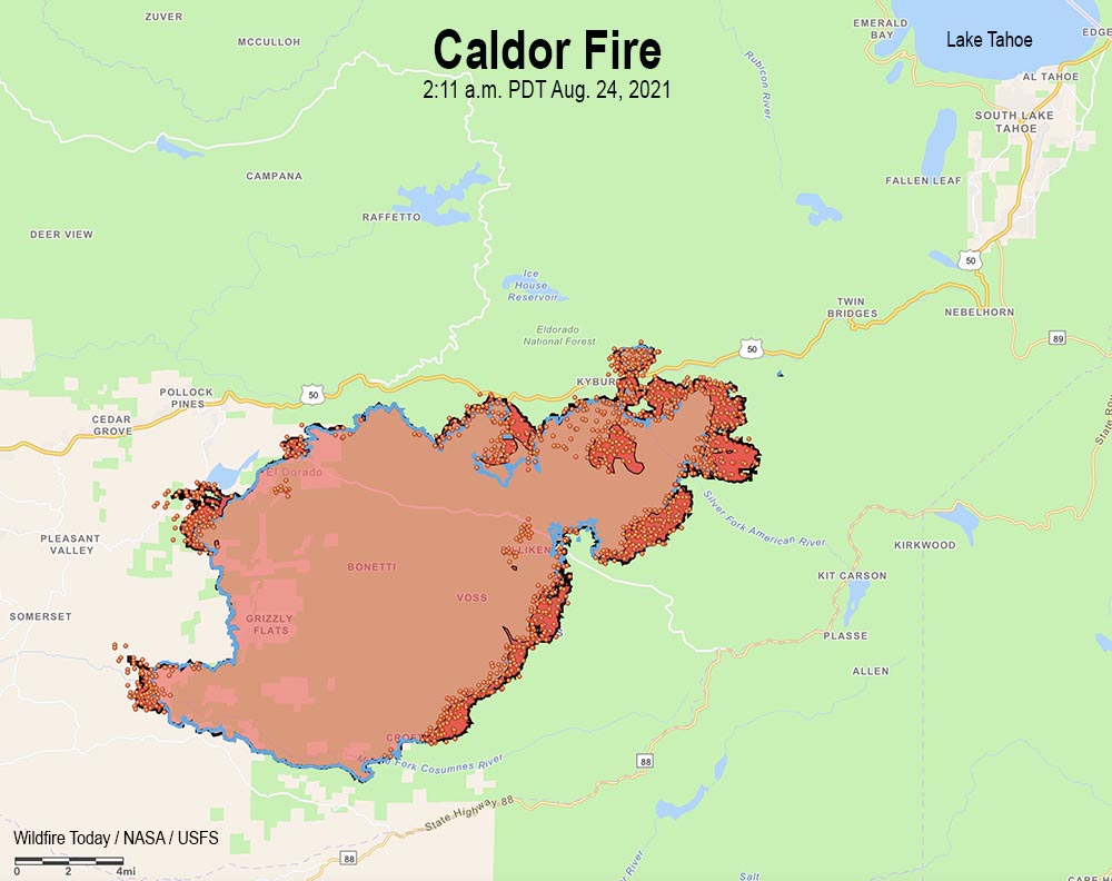
Map of the Caldor Fire.
Map of the Caldor Fire. The black line was the perimeter during a mapping flight at 11:17 p.m. PDT August 23, 2021. The blue line was the perimeter about 30 hours earlier. Red dots represent heat detected by a satellite at 2:11 a.m. PDT August 24, 2021. Dark red areas had intense heat during the last mapping flight.

The Caldor Fire grew by about 10,000 acres Monday under the influence of a 6 mph wind gusting out of the south, southwest, and west at 8 to 15 mph while the relative humidity was in the high 20s. Most of the activity was on the southeast and northeast sides. So far crews have been able to keep it south of Highway 50 except for a spot fire near Granite Springs Road that has burned several hundred acres. During a Monday night mapping flight the fire was about two miles southwest of Sciots Camp and 14 miles southwest of Lake Tahoe.

The fire was mapped Monday night at 117,000 acres.

Monday night fire activity moderated overall, but with some small spot fires and significant terrain-driven runs on the southeast side. Humidity recovery allowed crews to engage in direct control tactics and to continue indirect line construction.

To see all articles on Wildfire Today about the Caldor Fire, including the most recent, click HERE.

The Incident Management Team (IMT) reported Monday that in three or more days the following areas have the potential to be threatened: Silver Lake, Kit Carson, Plasse, Kirkwood, Twin Bridges, Sierra-at-Tahoe, Caples Lake, and the Lake Tahoe Basin.

Monday the IMT identified a long list of “critical resource needs” requested by today, Monday, including 330 engines, 60 hand crews, 17 Division Supervisors, and 40 other overhead personnel.

The weather forecast predicts very challenging conditions for firefighters over the next two days — strong winds Tuesday afternoon, 13 mph gusting out of the south-southwest at 20 mph, with 30 percent relative humidity and 70 degrees. Overnight the wind will slow to 6 mph from the southwest, then increase again Wednesday, 14 to 17 mph gusting up to 26 mph from the southwest with the RH in the low 20s.

This weather combined with the historically low fuel moistures could result in very significant growth of the fire Tuesday and Wednesday.

Damage inspections are in progress with approximately 40 percent of the current fire perimeter having being inspected. Crews have documented the destruction of 455 residences and 11 commercial structures. On the list of structures destroyed are one school, a church, a post office, and two fire stations (Grizzly Flats Forest Service and Pioneer Fire Dept. Station 35). PG&E currently has about 3,000 customers without power.

The El Dorado County Sheriff in collaboration with CAL FIRE has released a map displaying properties that have been inspected for any damage or that have been destroyed by the Caldor Fire.

Satellite photo smoke wildfires
Satellite photo showing smoke from wildfires at 5:51 p.m. PDT Aug 23, 2021.

Smoke and air quality August 24, 2021

Posted on Categories WildfireTags ,
Satellite photo smoke wildfires
Satellite photo showing smoke from wildfires at 5:51 p.m. PDT Aug 23, 2021.

Wildfires in Southern Oregon and Northern California continue to have a large effect on the air quality in those areas and neighboring states. The fires that are the largest producers of smoke in California are Monument, River, McCash, Antelope, Dixie, and Caldor. Several fires in Western Oregon are also contributors. After receiving rain in the last few weeks fire activity has decreased significantly in Washington, Idaho, and Montana.

Below is the forecast for wildfire smoke at 9 p.m. PDT Tuesday.

Smoke forecast for 9 p.m. PDT August 24, 2021 wildfires fire
Forecast for near surface smoke at 9 p.m. PDT August 24, 2021.
Air Quality at 6:48 a.m. PDT August 24, 2021
Air Quality at 6:48 a.m. PDT August 24, 2021. AirNow.gov

Dixie Fire grows by another 7,000 acres

725,000 acres have burned near Susanville, CA

Updated at 2:21 p.m. PDT August 23, 2021

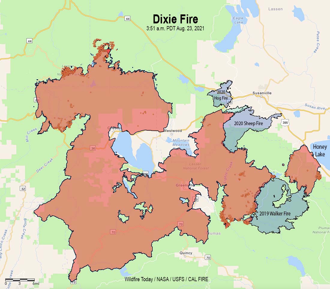
Dixie Fire map
Dixie Fire map. The black line was the perimeter mapped by a fixed wing aircraft at 8:00 p.m. PDT August 22, 2021. The red dots represent heat detected by a satellite at 3:51 a.m. PDT August 23, 2021. The dark red areas had extreme heat during the mapping flight.

The Dixie Fire was mapped Sunday evening at 725,821 acres after growing by about 4,000 acres in the previous 24 hours.

CAL FIRE has a list of changes in evacuation orders.

(To see all articles on Wildfire Today about the Dixie Fire, including the most recent, click HERE.)

Below is an update from the Incident Management Team on Monday:

“The eastern edge of the fire line towards Janesville area remains secure with crews on the ground continuing the mop up hot spots around the structures in Milford. On the southern edge above Antelope Lake, resources continue to work the fire’s edge to tie it into the Lake.

“In Genesee Valley, resources continue to mop up around structures. Firefighters are engaging the fire that has made its way down to the road as they continue to catch any spots or slops to secure it at the road. There are two spot fires on the south end of Genesee Valley. One is below the Grizzly Spot and will burn into it, the other has been contained in the creek. Today crews will work to minimize any spread moving towards homes.”


2:40 p.m. PDT August 22, 2021

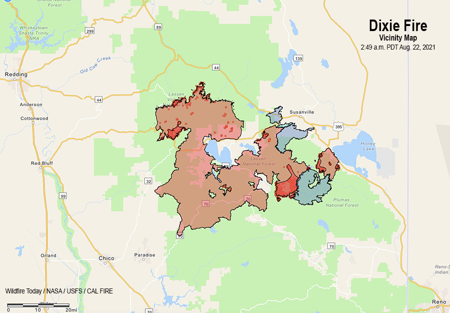
Dixie Fire vicinity map, August 22, 2021

The Dixie Fire in northern California near Susanville and Chester is still very active in five areas after having grown to 721,000 acres.

Working clockwise, starting on the east side:

  • West of Honey Lake and Highway 395. The spot fire that started five miles in front of the main fire and ran to the highway burning about 20,000 acres, is active on its southeast side not far from the highway and near Antelope Lake. Near Milford (see the map below) the fire crossed the line Saturday and winds quickly drove the fire toward structures. Crews, equipment, and engines were in place to protect the community and minimize impacts. Assessments are ongoing. On Sunday firefighters will continue to reinforce the lines and work to minimize any additional spread toward Milford. Other very active areas:
  • Wilcox Valley, and the area east of Taylorsville is very active and spreading.
  • Northeast of Mountain Meadows Reservoir near Hamilton Mountain Road south of Highway 36.
  • Northwest perimeter in Lassen Volcanic National Park.
  • West side near Mill Creek, Fire Mountain, and Highway 36.

On Sunday firefighters expect the fire to impact the west end of the Genesee Valley toward Taylorsville, threatening many structures along Genesee Valley road.

A much milder weather pattern is expected Sunday and into the middle of next week. A very weak area of low pressure will remain off the west coast through mid-week, keeping a light southwest flow over the incident with near normal temperatures and humidity values. Moderate overnight humidity recoveries may provide opportunities for line construction and firing operations.

Continue reading “Dixie Fire grows by another 7,000 acres”

French Fire near Isabella Lake grows to 13,000 acres

1:28 p.m. PDT August 23, 2021

French Fire map 8 p.m. PDT August 22, 2021
Map of the French Fire. The black line was the perimeter determined by a fixed wind mapping flight at 8 p.m. PDT August 22, 2021. The red dots represent heat detected by a satellite at 3:51 a.m. PDT August 23, 2021. The dark red areas had intense heat during the mapping flight. Green indicates Sequoia National Forest.

From the French Fire Incident Management Team at about 10:30 a.m. Monday:

“On Sunday, Aug. 22, fire crews constructed a handline near Wagy Flat Road (Forest Road No. 25S02) to hold the fire and connect into a previous controlled line. Crews were also successful continuing handline from the Sawmill Road break to the division break that is one mile south of Wagy Flat.

“Today [Monday] crews will continue to mop up in those areas and pay close attention to the structures off the Sawmill Road. Further west, towards Rancheria Road (Forest Road No. 25S15), there was some fire growth and fire crews successfully used dozers and hand crews to catch the smaller spot fire that slopped over onto Borderline Road. Crews will work towards Rancheria Road constructing direct line with a strong probability they can get up to Rancheria Road within the upcoming days.”


12:03 p.m. PDT August 22, 2021

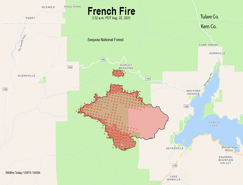
French Fire map
French Fire map. The black line was the perimeter determined by a fixed wing mapping flight at 8:32 p.m. PDT August 21, 2021. The red dots represent heat detected by a satellite at 2:32 a.m. PDT August 22, 2021. The dark red areas had intense heat during the mapping flight.

On Saturday the French Fire west of Isabella Lake in Southern California exhibited group torching of trees and long-range spotting, but the activity slowed during the night. The blaze has burned 13,341 acres.

For Sunday firefighters are concerned about the spot fire west of Alta Sierra which is a threat for the residences in that area.

Additional spread is possible with upslope runs and long range spotting to the east.

To see all articles on Wildfire Today about the French Fire, including the most recent, click HERE.

The weather forecast for Sunday calls for 2 to 6 mph winds out of the northwest, 77 degrees, and 40 percent relative humidity. Slightly stronger winds are expected on Monday with lower humidity.

Crews have confirmed that eight residences have been destroyed.

Evacuations are still in effect. The county has developed a map showing the areas affected.