Two firefighters at California fires died, one from COVID, the other from unspecified illness

Updated at 8:53 a.m. PDT Sept. 5, 2021

US Army soldiers fire training
Active duty US Army soldiers receive fire training before assisting at the Dixie Fire Sept. 1, 2021. About 200 soldiers have been activated to assist with wildfires in California. InciWeb.

Two firefighters assigned to wildfires in California have died.

One of two emails sent to employees on the Stanislaus National Forest about the fatality of one of their employee/retirees said he “passed away earlier this week due to complications of COVID-19 while assigned to the French Fire near Kernville, CA. He had been hospitalized in Bakersfield.”

The person’s name has not been released by the Stanislaus, but at least three sources confirm it was Allen Johnson.

Allen Johnson
Allen Johnson. USFS.

Allen was a Forest Service retiree and was working as an Administratively Determined (AD) employee on the French Fire. The email to the forest’s staff said it’s very early in the process, but “Tentative plans for honoring Allen include a Dignified Transport of remains followed by a Memorial Service. To the best of our current knowledge, Allen’s dignified transport and Memorial Service will occur on or after September 26.”

California Interagency Incident Management Team 14 posted on Facebook Sept. 1, 2021, “Our team, the firefighting community, and the world lost a great friend, mentor, teacher and comrade last night. Retired South Central Sierra Interagency Incident Management Team IC and Liaison Officer Allen Johnson passed away from complications related to COVID 19.”

So in the absence of official information from the US Forest Service about this line of duty death, it appears from the post by his incident management team that Allen died August 31, 2021.

Saturday night NBC Bay Area reported another fatality — a US Forest Service firefighter assigned to the Dixie Fire near Susanville, California.

A spokesperson for the U.S. Forest Service told NBC Bay Area Saturday that the firefighter, an employee with the Lassen National Forest died from an illness. The official added that the firefighter’s death was not related to the fire. No other details have been released at this time.

The official information from CAL FIRE about the Dixie Fire confirms there was a first responder fatality from an illness on September 2.

UPDATE at 11:08 a.m. PDT Sept. 6, 2021: NEWS4 reported today that the US Forest Service said the firefighter that died who had been assigned to the Dixie Fire was Marcus Pacheco, an assistant fire engine operator for the Lassen NF with 30 years of fire experience. He passed away Sept. 2 from what the USFS is calling an "unspecified illness". Late at night on September 5 the Lassen National Forest created a post on Facebook announcing the two fatalities and confirming the names.

The Dixie Fire has burned more than 889,000 acres near Susanville, California and is still actively spreading.

The 25,000-acre French Fire is west of Kernville, California.

Last week a strike team of five engines with 16 firefighters on the Caldor Fire near Lake Tahoe was quarantined for two weeks due to one of their members testing positive for COVID. There have been other reports of firefighters and crews sidelined, quarantined, or sickened, but specifics are hard to come by.

Two weeks ago Wildfire Today asked the five federal land management agencies for the number of their firefighters that have tested positive for COVID or had to quarantine after exposure. All five refused to release any information on the topic and would not explain their reasoning for keeping it secret. On September 2 we asked the US Forest Service again for the numbers of their firefighters who have tested positive for COVID, were hospitalized, or died. We are still waiting for the answers.

We send out our sincere condolences to the family, friends, and co-workers of the two firefighters who passed away while on duty.

(Edited to include the names of the firefighters.)

Thanks and a tip of the hat go out to people who passed along this information.

French Fire near Isabella Lake grows to 13,000 acres

1:28 p.m. PDT August 23, 2021

French Fire map 8 p.m. PDT August 22, 2021
Map of the French Fire. The black line was the perimeter determined by a fixed wind mapping flight at 8 p.m. PDT August 22, 2021. The red dots represent heat detected by a satellite at 3:51 a.m. PDT August 23, 2021. The dark red areas had intense heat during the mapping flight. Green indicates Sequoia National Forest.

From the French Fire Incident Management Team at about 10:30 a.m. Monday:

“On Sunday, Aug. 22, fire crews constructed a handline near Wagy Flat Road (Forest Road No. 25S02) to hold the fire and connect into a previous controlled line. Crews were also successful continuing handline from the Sawmill Road break to the division break that is one mile south of Wagy Flat.

“Today [Monday] crews will continue to mop up in those areas and pay close attention to the structures off the Sawmill Road. Further west, towards Rancheria Road (Forest Road No. 25S15), there was some fire growth and fire crews successfully used dozers and hand crews to catch the smaller spot fire that slopped over onto Borderline Road. Crews will work towards Rancheria Road constructing direct line with a strong probability they can get up to Rancheria Road within the upcoming days.”


12:03 p.m. PDT August 22, 2021

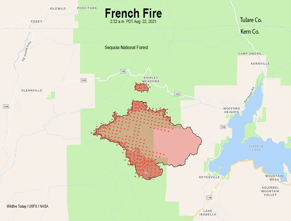
French Fire map
French Fire map. The black line was the perimeter determined by a fixed wing mapping flight at 8:32 p.m. PDT August 21, 2021. The red dots represent heat detected by a satellite at 2:32 a.m. PDT August 22, 2021. The dark red areas had intense heat during the mapping flight.

On Saturday the French Fire west of Isabella Lake in Southern California exhibited group torching of trees and long-range spotting, but the activity slowed during the night. The blaze has burned 13,341 acres.

For Sunday firefighters are concerned about the spot fire west of Alta Sierra which is a threat for the residences in that area.

Additional spread is possible with upslope runs and long range spotting to the east.

To see all articles on Wildfire Today about the French Fire, including the most recent, click HERE.

The weather forecast for Sunday calls for 2 to 6 mph winds out of the northwest, 77 degrees, and 40 percent relative humidity. Slightly stronger winds are expected on Monday with lower humidity.

Crews have confirmed that eight residences have been destroyed.

Evacuations are still in effect. The county has developed a map showing the areas affected.

French Fire prompts evacuations near Lake Isabella, California

The fire has burned more than 11,000 acres

9:53 a.m. PDT August 21, 2021

French Fire map
Map of the French Fire. The red dots represent heat detected by a satellite at 2:49 a.m. PDT August 21, 2021.

Friday night the French Fire west of Isabella Lake near Kernville, California grew a bit to the north and southwest while under the influence of a light and variable wind from the south, east, and southeast. (See the map above) The relative humidity which was in the 30s and 40s Friday rose into the 40s again Friday night.

The weather forecast for Saturday calls for stronger winds in the afternoon, 11 mph out of the northwest gusting to 16 mph, with the relative humidity around 40 percent. By 6 p.m. the humidity will begin climbing rapidly, reaching 80 percent by 8 p.m. and remaining above 60 percent the rest of the night.

To see all articles on Wildfire Today about the French Fire, including the most recent, click HERE.

The Incident Management Team reports that the fire has destroyed two structures and burned 11,295 acres. They expect the fire to continue to move toward the communities of Alta Sierra, Alta Sierra Ski Resort, Isabella Highlands Community, Dutch Flat Community, and surrounding areas. Evacuations are still in effect.

Resources assigned to the French Fire Friday evening included 28 hand crews, 52 fire engines, and 5 helicopters for a total of 883 personnel.

French Fire evacuation map
French Fire evacuation map. Accessed at 10 a.m. PDT August 21, 2021. Posted by Kern County Fire Department.

6:22 p.m. PDT August 20, 2021

The French Fire in Kern County, California started Wednesday, August 18, around 4:30 p.m. on the west side of Lake Isabella. (See map above.) On Thursday firefighters were faced with shifting winds driving the fire in several directions, but in the afternoon wind from the southwest and later the south pushed the fire northwest and north.

Friday morning 5 to 10 mph east and northeast winds gusting at 12 to 18 drove the blaze to the west and northwest, but after 3 p.m. 8 to 12 mph winds gusting out of the south at 15 to 18 mph pushed the fire vigorously to the north.

French Fire, looking south-southeast from Shirley Peak
French Fire, looking south-southeast from Shirley Peak at 1:12 p.m. PDT August 20, 2021.

The fire burned over the location of the Shirley Peak camera, but hours later it was still transmitting images of very dense smoke through a dirty lens.

At about 3 p.m. Friday InciWeb reported the following evacuation orders:

  • Wagy Flat Road east to Lake Isabella, between Old State Road south to Keyesville.
  • Keyesville south, from the intersection of Black Gulch Road and Forest Route 26S06, continuing east to Highway 155.

Kern County has posted an evacuation map.

Friday morning the fire was mapped at 4,272 acres, but the push to the north in the afternoon likely added significantly to that number.

Thursday evening resources assigned to the fire included 15 hand crews, 47 engines, and 5 helicopters for a total of 650 personnel. On Friday the number of personnel had increased to 809.

The GOES-17 satellite could easily photograph the smoke plume Friday afternoon as the intensity increased significantly.

French Fire satellite photo
French Fire, photographed by GOES-17 at 5:36 p.m. PDT August 20, 2021.
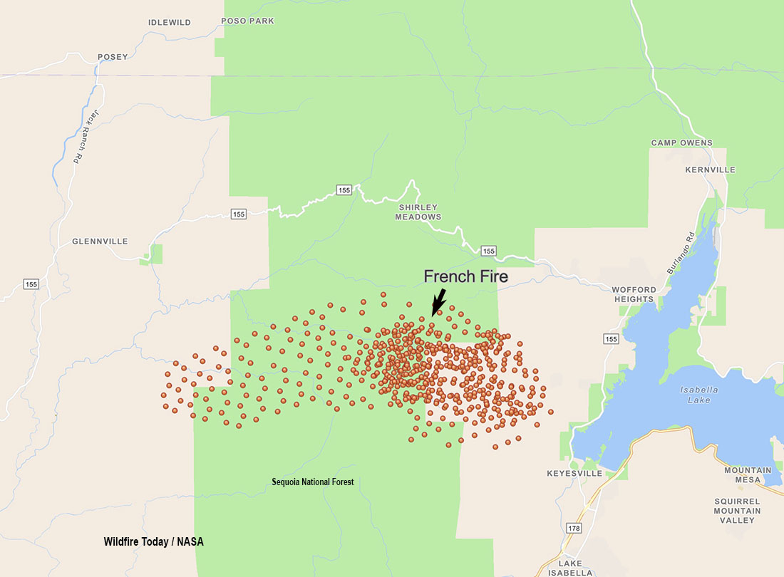
French Fire 1249 p.m. PDT August 20, 2021
French Fire. The red dots represent heat detected at 12:49 p.m. PDT August 20, 2021. Later in the afternoon the wind shifted and drove the fire to the north. The finger of red dots on the west side turned out to be false positives.