Incidents within incidents, this week on wildfires

Thursday morning, September 15, Bill Waterbury, the assistant Director for Risk Management for the US Forest Service in Boise, assembled a list of incidents-within-incidents that occurred on wildfires during the first four days of the week.

=============

This week of September 12th in perspective

Sunday, September 11, 2011, Prescribed Burn Shelter Deployment

Around 1400 on Sunday, September 11, a Forest Service employee deployed his shelter while working on a prescribed burn on the Jessieville Winona Fourche Ranger District on the Ouachita National Forest in Arkansas.  The employee suffered 2nd degree burns on 2% of his body (face and hands) and is currently at the Arkansas Children’s Hospital burn unit in Little Rock, Arkansas. [Note from Bill G.: the official 24 report is here, but has little more information.]

Monday, September 12, 2011, Employees entrapped

Six employees, composing three two-person “Public Safety Teams” of trained wilderness rangers, who were making public contacts to ensure that no recreationists were in areas under closure order because of the Pagami Creek Fire were involved in a shelter deployment the afternoon of Monday, September 12.  The teams were on remote assignment to assure compliance with the closure order and had appropriate PPE and training.

Tuesday, September 13, 2011 1:59 PM, Missing Private Aircraft – Salt Fire

A private plane, transporting the owner of Blaze Runner contract engines, is missing.

The plane left Salmon at approximately 2200 on 9/12 with a planned destination of Boise. At around 0330, members of the Blaze Runner crew were informed that the aircraft had not arrived in Boise.  It was found late Tuesday with both pilot and passenger killed. [note from Bill G.. We wrote about the incident in this article.]

Tuesday, September 13, 2011 4:08 PM, Employee injury due to lightning 

3 employees on the Mt. Pinos RD who were struck (not directly) by lightning.  All employees are stable, and being transported via Ventura County helicopter to the hospital for examination.  The employees were part of Crew 8 (Sundowners), Ojai RD.  I will pass along additional information as it becomes available. [note from Bill G.: we covered this on Sept. 13]

Wednesday, September 14, 2011 10:12 PM, Injuries on Boise NF

Three firefighters injured on small fire on the Boise when hit by a rolling log.  Two with minor injuries, one medivac after losing consciousness.  Will know more in the morning.


Thanks go out to Jim

Minnesota: Pagami Creek fire mapped at 100,000 acres, evacuations ordered

A fire that started in the Boundary Waters Canoe Area Wilderness (BWCAW) and was not suppressed for about two weeks, has burned outside the BWCAW and become the largest fire in Minnesota since 1918. The Pagami Creek fire has burned 100,000 acres, according to the incident management team, and forced evacuations on the south and east sides of the fire. Scroll down to see maps of the fire.

It started from a lightning strike on August 18 and by August 30 had burned approximately 130 acres.

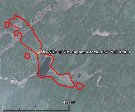
Map Pagami Creek fire 0800 8-30-2011
Map of the Pagami Creek fire at 8:00 a.m. CT, August 30, 2011. Credit: Superior National Forest and Google Earth

The staff at the BWCAW and the Superior National Forest decided to monitor it and allow natural processes to run their course. They conducted some firing operations, burning an additional 2,000 acres, to herd the fire away from populated areas on the north and west sides, but by last weekend it was obvious that they needed to suppress it. Strong winds on Monday of 15-20 mph gusting up to 35 mph spread the fire 16 miles to the east. At that point the intensity of the fire far exceeded the capabilities of the fire suppression forces. Winds again on Tuesday spread the fire even further, to the point where it is now mapped at 100,000 acres. However the smoke makes mapping difficult, and that acreage may change after firefighters can actually see the full perimeter.

The Pagami Creek fire is ranked as the third largest fire in the history of Minnesota. Larger fires were the 250,000-acre fire near Cloquet in October of 1918 which killed 559 people, and a 200,000-acre fire near Hinckley in September of 1894 which killed 418 people. Here is a link to more information about “Infamous Fires”.

The maps below show what it looks like now:
Continue reading “Minnesota: Pagami Creek fire mapped at 100,000 acres, evacuations ordered”

USFS Chief issues statement about air tanker availability

CL-215 and CL-415
CL-215 and CL-415 Medium Type 3 air tankers scoop water from Snowbank Lake while working on the Pagami Creek fire recently in the Boundary Waters Canoe Area in Minnesota. Photo by Kristi Marshall for the Superior National Forest

(This article was updated on September 14 to reflect that there are now eight Convair CV-580 air tankers working temporarily in lower 48 States.)

The U. S. Forest Service is apparently feeling the heat from the public and politicians about the agency’s management, or lack thereof, of the large air tanker fleet, which through neglect has dwindled from the 44 we had in 2002 to the 11 large air tankers currently on exclusive use contracts. The decline began with the crash of two very old military surplus air tankers in 2002, which prompted the permanent grounding of similar antiques. But in the nine years since those crashes, nothing significant has been accomplished to rebuild the fleet.

This morning there were 11 air tankers on exclusive use contracts, plus 12 hired temporarily on a day basis (including one DC-10) and six or seven military C-130 MAFFS on a temporary assignment. There were no federal large air tankers in the states of New Mexico, Arizona, Colorado, Wyoming, South Dakota, Minnesota, Montana, or Washington. I wonder if the firefighters on the ground in those states know they will get no large air tanker support for the initial attack of fires?

Here is a statement that was issued around September 8, 2011 by the U. S. Forest Service. Our comments are embedded in red.

==================

Statement from US Forest Service Chief Tom Tidwell on Aircraft Support for Texas, Other Wildfires Throughout the Country

The Forest Service is working hard right now with our federal, state and local partners to combat fires in Texas, California and several other states. I want to assure the public that the Forest Service has ample aircraft strategically placed around the country to support on-the-ground teams combating this year’s wildfires. Our current available airplane fleet includes: “Ample aircraft”? One of the many USFS air tanker studies shows that we should work toward a goal of 32 large air tankers on exclusive use contracts. Now we have 11. 

  • 17 Large Air Tankers which have a capacity of delivering an average of over 2000 gals. of water or retardant per trip. We have 11 “Large” air tankers on exclusive use contracts. Within the last few weeks the USFS brought in on a temporary day by day basis eight “Large” Type 2 Convair CV-580 air tankers, three from the state of Alaska and five from the Canadian government.
  • 1 DC-10 Very Large Airtanker with a capacity of 12,000 gals. This was hired on a day by day Call When Needed contract. The USFS refuses to award any exclusive use contracts for Very Large Air Tankers, such as the DC-10s or the 747, which can carry 11,800 and 20,000 gallons, respectively.
  • 8 military aircraft specially outfitted to fight fires with an average capacity of 3000 gals. Six have been activated. Four are in Texas and two are in Idaho. CAL FIRE may have activated a seventh one for state responsibility fires in California.
  • 3 CL- 215 scooper aircraft which can deliver an average of 1300 gals. of water per trip.These are on a Department in Interior CWN contract. They are trying to get two more through an international agreement with Canada.
  • More than 100 wildland fire response helicopters, including exclusive use contracts for:
    • 2 dozen Type-1 heavy helicopters
    • Over 40 Type-2 medium helicopters on national contracts
    • Over 50 Type-3 light helicopters on local or regional contracts
    • Additional helicopters are available through call-when-needed contracts

All of these assets support the more than 16,000 federal firefighters (10,500 are Forest Service), and 1000 Forest Service firefighting engines.

The Forest Service takes the safety of our employees and contractors seriously and we insist on maintaining stringent airworthiness standards that were developed after two airtankers crashed in 2002, resulting in the loss of both crews. The Forest Service does not take shortcuts on safety. No responsible person is saying waiting more than nine years to make a decision about how to rebuild the air tanker fleet is taking a “shortcut”.

Lightning strike injures three firefighters

Posted on Categories Uncategorized

Three wildland firefighters injured by a lightning strike were treated at a hospital Tuesday. The firefighters were working on the Frazier One fire on the Los Padres National Forest in southern California when lightning struck about 50 feet away. They were not hit directly, but the jolt left them disoriented and they had ringing in their ears. The firefighters were flown to a hospital where they are listed in stable condition. They could be released as early as Tuesday night.

Here are some lightning-caused injuries that we have reported on over the last several years:

Minnesota: strong winds spread the Pagami Creek fire 16 miles to the east

Pagami Creek fire September 11, 2011.
Pagami Creek fire September 11, 2011. Photo: Superior National Forest

=================

UPDATE AT 12:48 p.m. CT, September 14, 2011:

Updated information about the Pagami Creek fire.

=================

UPDATE at 10:53 p.m. CT, September 13, 2011: The InciWeb site for the Pagami Creek fire was updated about an hour ago, and includes a new figure for the size of the fire: 100,000 acres. Maps of the fire can be found on the InciWeb site…if it is up and running. It had problems off and on today.

==================

Monday morning the Pagami Creek fire in Minnesota’s Boundary Waters Canoe Area Wilderness (BWCAW) east of Ely was 11,000 acres. Today I saw a map that was updated at 7:00 p.m. Monday night. From my very unofficial estimate derived from counting 640-acre sections that had burned, the fire had blown up to over 70,000 acres. The maps may be an overestimate of the fire’s size; mapping it was difficult due to the smoke. Here is a link to a different, but current as of Monday night, map of the fire.

The Associated Press is reporting 60,000 acres, a figure which apparently came from Minnesota Interagency Fire Center spokeswoman Jean Bergerson Tuesday morning. InciWeb, which at times has been having problems today, was updated at noon on Tuesday with this information:

Yesterday, a finger of the Pagami Creek Fire made an unprecedented 16 mile run to the east, reaching the edge of Polly Lake. The fire became a plume-driven event and reached in excess of 60,000 acres. Residents were evacuated from 36 addresses along the portion of the Cramer Road/Lake County Road 7 from Kawishiwi Lake south to the Wanless Road (Forest Road 172) and along the Wanless Road west from the junction with the Cramer Road to Homestead Lake. Winds are expected to be strong and out of the northwest and west again today with little or no precipitation expected.

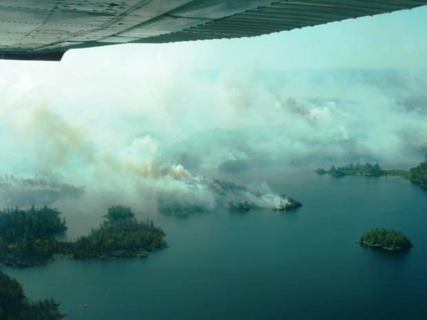
Pagami Creek fire, burns along lake shore
Pagami Creek fire, burns along lake shore in undated photo by Superior National Forest

The blowup was caused by 15-20 mph west and northwest winds on Monday that gusted up to 35 mph pushing the fire approximately 16 miles to the east. The National Weather Service is predicting strong northwest winds again on Tuesday of 18 mph gusting to 28 along with a relative humidity of 37%. But between 2 and 6 p.m. there is a 45 percent chance of showers. Tuesday’s high temperature will be 60 in Ely, but on Wednesday it will cool off quite a bit with a high of only 46, with winds of 14 mph gusting to 18.

Check out this animation of smoke from the fire as seen from a satellite on September 11. And HERE is an excellent gallery of pictures of the fire…taken from the ground.

The Pagami Creek fire is the largest in the state since the Ham Lake fire burned over 76,000 acres in Minnesota and Ontario in May 2007, destroying 163 structures near Gunflint Trail.

Doug Turman’s Type 1 Incident Management Team has been dispatched to the fire and will assume command at 6:00 p.m. on Tuesday. Maybe his team will have better luck obtaining firefighting resources. Here is an excerpt from an article posted Monday night in the Lake County News-Chronicle (you may need to register to view the site):
Continue reading “Minnesota: strong winds spread the Pagami Creek fire 16 miles to the east”