Update on fires in Texas, Sept 6

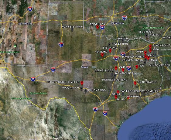
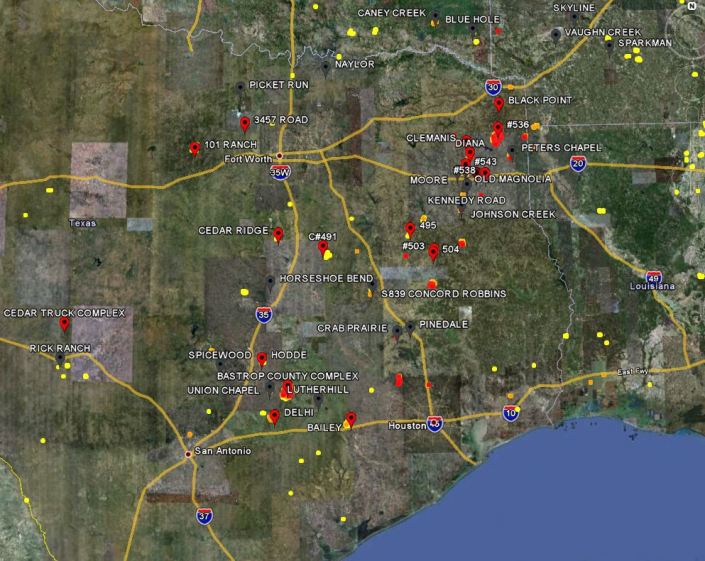
Map of large fires in Texas, 9-6-2011
Map of large fires in east Texas, September 6, 2011. Google Earth

Earlier today we posted a map and an update about the Bastrop fire in Texas which has destroyed 600 homes, setting a record for highest number of homes lost in a single fire in Texas history.

The Texas Forest Service is reporting that statewide more than 700 homes have burned during the recent siege of fires. Governor Rick Perry said today in a news conference that over 1,000 homes have been destroyed (video) and that 3,600,000 acres have burned since December, a size equal to the state of Connecticut.

Updating the article and map from yesterday about the wildfire situation across the state, the current conditions are a little better, in that the very strong winds produced by tropical storm Lee have diminished to about 11 mph today. However with 33 large fires burning in east Texas that grew out of control during the wind event, firefighters will have their hands full for days, at least. Since yesterday The Texas Forest Service (TFS) has reported 10 new fires larger than 100 acres.

On Monday Jeremy Richter took some photos of some of the fires in Texas from an aircraft. Check them out at his site. CBSnews.com has a gallery of photos of the fires.

The TFS has created a Google map of the fires.

Here are some brief descriptions from the TFS of the 10 largest fires:

BASTROP COUNTY COMPLEX, Bastrop County. 30,000 acres, no containment. Heavy airtankers and single-engine airtankers assisted on this fire that started in the Lost Pines area just northeast of Bastrop. The fire continues to move rapidly to the south, with some eastward movement. Numerous subdivisions have been evacuated. Reports indicate nearly 600 homes have been destroyed.

DELHI, Caldwell County. 8,000 acres, 40 percent contained. Twenty homes were saved and six were lost on this fire east of Lockhart.

BEAR CREEK (#536), Cass County. 7,000 acres, no containment. The fire is burning in heavy timber and is threatened a gas facility and chicken houses.

101 RANCH, Palo Pinto County. 6,555 acres, 85 percent contained. The fire is burning on the south side of Possum Kingdom Lake near the town of Brad. Thirty-nine homes and nine RVs have been reported destroyed.

PEDERNALES BEND, Travis County. 6,500 acres, 40 percent contained. The fire is burning 4 miles southeast of Spicewood. Sixty-seven homes were destroyed. The fire has jumped the Pedernales River and is burning actively towards the south.

HENDERSON #495, Anderson County. 3,700 acres, unknown containment. Three homes were saved.

RILEY ROAD, Grimes County. 3,000 acres, unknown containment. The fire is exhibiting extreme fire behavior as it burns rapidly west of Magnolia. At least 20 homes have been destroyed, with 150 immediately threatened and hundred more in its path. The fire is actively moving to the south.

#491, Limestone County. 3,000 acres, unknown containment. Six homes were saved and one was lost on this fire 20 miles east of Waco.

#502, Nacogdoches County. 2,900 acres, unknown containment. More than a dozen homes have been evacuated, but none lost.

LUTHERHILL, Fayette County. 2,000 acres, 50 percent contained. The community of Ruttersville was evacuated. Seven homes are reported lost.

Visit our home page to see the latest articles.

Do us a favor. If you appreciate this article, click the +1 button below to recommend it to Google. Thanks!

Bastrop fire in Texas burns 600 homes

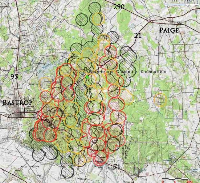
Map of Bastrop fire in Texas 9-6-2011
Map of Bastrop fire in Texas, showing heat detected by satellites early in the morning on September 6, 2011. The location is approximate. The most recent heat is shown in red. MODIS

(UPDATE September 7, 2011: maps updated on September 7, 2011, can be found HERE.)

The fire between Bastrop and Paige in Texas has burned approximately 600 homes and 30,000 acres, according to the Texas Forest Service. The fire has set a record for the highest number of homes lost in a single fire in Texas history.

The west flank of the fire is threatening Bastrop and is within two miles of the city limits. The strong winds blowing out of tropical storm Lee have abated somewhat, but the predicted 11 mph north-northeast winds and a relative humidity of 14% today will continue to challenge firefighters charged with protecting the town of Bastrop.

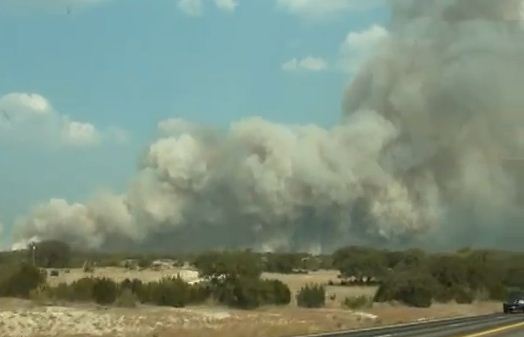
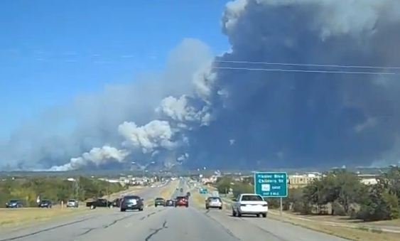
Bastrop fire screen capture from video
Bastrop fire as seen from Route 71 near Route 20. Screen capture from video. Credit: hippychickenfarmer

The image above is from a video on YouTube.

The Boise National Incident Management Organization team, Incident Commander Steve Gage, has assisted with the management of the fire. A type 1 team has been ordered. Numerous subdivisions, approximately 5,000 residents, have been evacuated.

Author and photographer Deanna Roy took a very impressive photo of the Bastrop fire with the city of Austin in the foreground.

Yesterday we posted a map showing the locations of the 38 large fires burning in Texas. We will post another article later updating that information about the fires across the state. The Texas Forest Service has a list of the large fires currently uncontrolled.

Visit our home page to see the latest articles.

Do us a favor. If you appreciate this article, click the +1 button below to recommend it to Google. Thanks!
Forest Service fails to deliver air tanker report

The U. S. Forest Service has missed another deadline to produce a report about how to deal with the severe shortage of large air tankers. A strategy to replace the dozens of air tankers that were permanently grounded after two very old military surplus air tankers fell apart in mid-air in 2002 should have been developed no later than 2004. Since then, missing promised reports combined with analysis paralysis have resulted in the large air tanker fleet being reduced to 11 on July 29, compared to 44 in 2002. The USFS keeps saying that they have plenty, but in the last couple of weeks they brought on additional air tankers, including three Convair 580s and three CL-215 scooper air tankers, bringing the total to 17 medium and large air tankers on exclusive use contracts. Correction. “JR” tells us that the CL-215s are working on a Call When Needed contract day by day, so they could disappear any time.

The Riverside, California Press-Enterprise follows wildfire very closely and on Saturday published an article detailing the USFS’ multiple failures to produce the reports about how to reconstitute the large air tanker fleet. Here is an excerpt from the article written by Ben Goad:

WASHINGTON – The U.S. Forest Service has again missed its deadline to complete studies needed to shape the agency’s future aerial firefighting strategy, igniting concern from a California lawmaker as wildfire season intensifies across the Inland area.

The Forest Service’s director of fire and aviation, Tom Harbour, acknowledged Friday that some of the review work initially scheduled to be complete in January won’t be finished until next year. Harbour attributed the delays to the complexity and high stakes — both in terms of cost and human lives — involved with modernizing the federal aerial firefighting fleet and accompanying policies.

He stressed that plenty of resources are on hand to battle flames in Inland Southern California, where several blazes have ignited in recent days, including a wildfire Friday in the Cajon Pass that shut down Interstate 15.

“This fall in SoCal, we’ve got more than enough stuff to cover the fire needs,” Harbour said.

For example, he said, three CL 215 firefighting planes known as “Scoopers,” able to drop hundreds of gallons of water at a time on flames in remote areas, were brought to the San Bernardino National Forest during a recent blaze.

But Sen. Dianne Feinstein, who first raised concerns about the delays in February, said she remains unsatisfied with the agency’s progress and said she plans to seek answers from Harbour’s boss.

“Fire season has begun in California, and millions of acres are at high risk of wildfire,” said Feinstein, D-Calif. “I intend to meet with Forest Service chief Tom Tidwell to understand why they have again failed to meet this deadline and enact a strategy to protect Californians from wildfires in the coming years.”


Thanks go out to Dick

Over 400 homes burn in Texas wildfires

Strong winds and low humidities from Tropical Storm Lee without the benefit of any rain have created conditions ripe for wildfires in Texas. The Texas Forest Service is reporting that approximately 429 homes have been destroyed in the 38 large fires that are currently burning.

Large fires in Texas, 9-5-2011
Map showing some of the large fires currently burning in Texas, 9-5-2011. Credit: Texas Forest Service

On Sunday Texas mobilized additional National Guard Blackhawk helicopters and Texas Intrastate Fire Mutual Aid System (TIFMAS) strike teams as well as a heavy airtanker from South Dakota. At this time dozens of firefighting aircraft are being used, including four heavy airtankers, 15 single-engine airtankers, 12 helicopters, and 13 aerial supervision aircraft. A Type 1 incident management team has been requested to assist with the Bastrop County Complex.

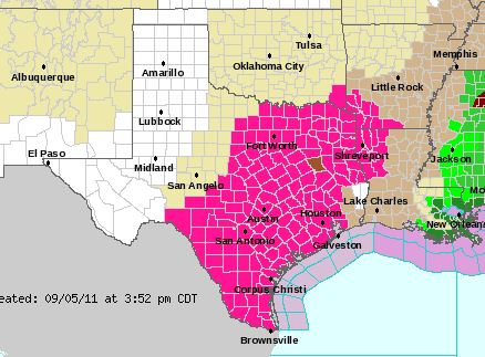
The strong winds are expected to continue over the east half or more of the state along with drier relative humidities into the 10 to 20 percent range across much of the state. High temperatures will be in the upper 70s to lower 80s over a large portion of North Texas to near 100 over Deep South Texas near the Mexico border. The stronger winds are expected to weaken over most of the state Monday night.

Red Flag Warnings in Texas, September 5, 2011
Screen shot from YouTube video

The image above is a screen capture from a video of a fire near Spicewood, Texas.

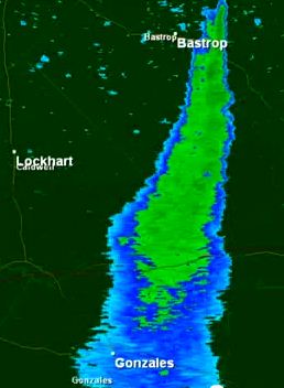
Radar image of smoke from Bastrop County Complex fire
Radar image of smoke from the Bastrop County Complex fire

Below is information about the 10 largest fires in Texas, provided by the Texas Forest Service, September 5:

====================

BASTROP COUNTY COMPLEX, Bastrop County. 14,000 acres, no containment. Heavy airtankers and single-engine airtankers assisted on this fire that started in the Lost Pines area just northeast of Bastrop. The fire has moved unchecked for at least 16 miles to the south and has jumped the Colorado River twice. The Circle D, K.C. Estates, Pine Forest, Colovista and Tahitian Village subdivision have been evacuated. Firefighters are trying to hold the fire at FM 2571. Reports indicate possibly 300 homes have been destroyed. MODIS satellite image indicates the fire has jumped Highway 95 and is approximately 25,000 acres.

STEINER RANCH, Travis County. 150 acres, no containment. The fire started just north of the Steiner Ranch subdivision. More than 1,000 homes are under mandatory evacuation in Steiner Ranch. At least 25 homes are reported lost. A Texas Intrastate Fire Mutual Aid System strike team responded.

PEDERNALES BEND, Travis County. 7,000 acres, unknown containment. The fire is burning four miles southeast of Spicewood. Twenty homes were lost, 30 homes damaged.

HENDERSON #495, Henderson County. 5,000 acres, unknown containment. Three homes were saved.

#491, Limestone County. 3,000 acres, unknown containment. Six homes were saved and one was lost on this fire 20 miles east of Waco.

DELHI, Caldwell County. 1,000 acres, 10 percent contained. Twenty homes were saved and six were lost on this fire east of Lockhart.

BAILEY, Colorado County. 1,000 acres, unknown containment. This fast-moving fire threatened 40 homes near Columbus. Blackhawks, single-engine airtankers and a heavy airtanker assisted.

MOORE, Smith County. 927 acres, 5 percent contained. Ten homes were evacuated and five were lost on this fire burning on the Smith/Gregg County line. Two civilian fatalities were reported.

#545, Upshur County. 500 acres, 50 percent contained. One hundred homes were saved; none lost. The fire is burning East of Gilmer.

LUTHERHILL, Fayette County. 2,000 acres, unknown containment. The community of Ruttersville was evacuated. Seven homes are reported lost.

Visit our home page to see the latest articles.

Four runners in ultramarathon trapped and burned in wildfire

Four runners competing in a 62-mile ultramarathon in Western Australia were trapped by a fire and seriously burned.

From the Herald Sun:

A VICTORIAN woman is fighting for her life in hospital after competing in an ultra-marathon ravaged by bushfire. The victim, named locally as 35-year-old Kate Sanderson from Mornington, is believed to have suffered between 60 to 80 per cent burns to her body. She was running the 100km course in far northern WA on Friday at 5pm when a wildfire trapped her and three others in a small gorge near Kununurra.

Turia Pitt, a 24-year-old originally from NSW, is also in a critical condition, while two men have also suffered severe injuries.

The Royal Flying Doctor Service flew the two women to Darwin hospital. Two men, aged 44 and 56 and with 10 to 20 per cent burns, were flown to Perth yesterday.

Competitor Oskar Booth, 24, said the runners became trapped in a narrow gorge.

“As we came out of checkpoint two, we came into a large amount of smoke but couldn’t see any flames,” Mr Booth said.

“The fire seemed to have accelerated and gone up to the gorge and trapped people. I could see thick plumes of smoke and it was getting hard to breathe – that’s when I realised it was serious.”

A Western Australia Police arson squad detective and Fire and Emergency Services Authority fire investigator travelled to the tragic scene, amid fears the fire may have been deliberately lit.

Royal Flying Doctor Service spokeswoman Joanne Hill said the four people were trapped in a gorge at El Questro Station.

“They were running through the gorge and a bushfire held them up and they had nowhere to go,” she said.

Fire in southern California’s Cajon Pass burns 1,100 acres

DC-10 dropping on Hill fire Sept 2
DC-10 air tanker drops on the Hill fire in Cajon Pass on Sept 2. Photo: Irfan Khan, Los Angeles Times

Friday night firefighters were beginning to slow the spread of the Hill fire which had burned 1,100 acres in Cajon Pass east of Los Angeles. The fire, which at times has halted traffic on Interstate 15, is being managed by resources from CAL FIRE and the San Bernardino National Forest.

One firefighter was transported off the fire for a medical emergency. A second firefighter suffered heat exhaustion. Resources on the fire include 72 fire engines, 5 dozers, 5 water tenders, 5 helicopters, 14 airtankers (including the DC-10) and 22 handcrews. A total of 831 people were assigned to the fire.

The Los Angeles Times has a gallery of excellent photos of the fire, such as the one above. Check it out.