Wildfire news, July 28, 2011

Wildfires may redistribute radioactive fallout debris

The NuclearCRIMES.org web site has posted a document that contains information about how radioactive fallout debris from nuclear bomb testing and the meltdown of the Chernobyl nuclear power plant can be transported initially to remote locations, and years later be re-suspended into the air during a wildfire.

Here is an excerpt from the site:

Over the past two weeks, a Chernobyl Reloaded has been in the making, thanks to wildfires that are breaking out in parts of Russia that received some of the greatest deposition levels from Chernobyl fallout. Long-lived radioactive isotopes, such as Cesium-137 and Strontium-90, which are deposited from fallout events such as nuclear weapons tests and large-scale radiological accidents, tend to reside in the top few inches of the soil and also become lodged in vegetation and dead biomass. Hot burning wildfires – such as a record-breaking, large wildfire in 2007 that lifted legacy fallout radiation north of Milford, Utah – can suspend back into the air up to 100% of this lingering radioactivity where winds can carry these carcinogens.

Followup on the lead plane photos

After we posted photos of lead plane 6-5 on July 19 and July 26, we received a message from Jonas Doherty, who provided some interesting details about the photos. Here is an excerpt:

I was the pilot flying the lead plane when you took those pictures. What makes it better is the fact that that actual mission was my final evaluation flight in order to become fully qualified for the lead plane mission. I have been training for the past 1.5 years, the final checkride consisted of 9 seperate missions over the course of a week, the whoopup being the last. It means so much to me to have the article that you wrote as a memory of that day. Your pictures are incredible, and I would love to see more if you would be gracious enough to share them with me.

Just a couple things to clarify regarding the article (as though they matter.) We were actually dispatched out of Silver City, NM. Also, the 5 aircraft that the BLM operates have smoke, but none of the 14 USFS aircraft have it…yet, that is.
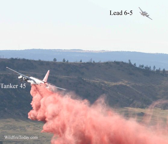
Whoopup fire Lead 6-5 and Tanker 45
Lead 6-5 and Tanker 45 on the WhoopUp fire near Newcastle, WY, July 18, 2011. Photo by Bill Gabbert

We also heard from Chuck Greenwood, the owner of the Greenwood Group, who told us that his company has the contract to supply the lead planes for the U.S. Forest Service. The pilots are USFS employees.

Eagle fire: activity “minimal”

The Eagle fire burning between Warner Springs and Borrego Springs in southern California, has slowed. At the end of the day on Wednesday, CalFire called fire activity on the fire “minimal”. As of Thursday morning it has burned 14,100 acres and has 20 helicopters and over 2,000 personnel assigned. Fire investigators determined that the cause of the fire was arson.

DC-10 worked the Eagle fire on Wednesday

CalFire activated one of the DC-10 air tankers for the Eagle fire in southern California yesterday. Air Tanker 910 flew 5 sorties and dropped 58,000 gallons of retardant on Wednesday.

Rick Hatton, the CEO and President of the company that operates the DC-10’s, 10 Tanker Air Carrier, told Wildfire Today that the aircraft was activated by CalFire on a 5-day Call When Needed (CWN) contract which specifies that any activation will be for a 5-day minimum. The USFS would not allow any minimum number of hours or days in their CWN contract with the company, so the agency apparently expects to use it for one drop, or more, and then shut it down. Mr. Hatton said it will be difficult to continue to operate their two DC-10 air tankers if they are only occasionally used on fires. They are single-purpose aircraft and can’t be diverted like helicopters can to other uses such as law enforcement or news.

Mr. Hatton said that yesterday tanker 910 refilled at Victorville airport, even though CalFire removed all of their property from the reload base on June 30. What remained was the actual reloading equipment, the tanks, mixing equipment, piping, and hoses, which belong to Phos-Chek. Personnel were dispatched to operate it, and they reloaded the tanker five times on Wednesday, each time with 11,600 gallons of Phos-Chek.

Two DC-10 air tankers
File photo of air tankers 910 and 911. Photo: 10 Tanker Air Carrier

CalFire reportedly likes to use the DC-10’s on fires, but the state’s budget problems required that they make $34 million worth of reductions in their fire program this year, including:

  • 730 fewer seasonal firefighters
  • Reducing the staffing on engines from four to three
  • Cancellation of the exclusive use contract for the DC-10 air tanker

Norton Point fire burns into the high country

Norton Point fire
Norton Point fire along Frontier Creek. Photo: InciWeb

The Norton Point fire 19 miles north of Dubois, Wyoming has been burning vigorously over the last 48 hours or so, but in some areas it has moved into the high country of the Washakie Wilderness, where vegetation, or fuel, may become a limiting factor. The fire ranges from about 8,000 feet in elevation up to 10,000 feet, above which, the fuel, like the air, starts to become thin, which in some areas may slow down or even stop the spread. It is being managed at something less than a full suppression strategy. The IMTeam wrote on Inciweb:

The team is planning for a fire that may burn until snowfall.

Yesterday it was listed at 3,500 acres but an infrared mapping flight at 2:03 a.m. MT today revealed that it had grown to 9,320 acres. And judging from a heat detection map I saw this afternoon, that number is obsolete. Smoke from the fire is visible on weather satellite photos Wednesday afternoon .

Norton Point 3-D fire map 0203 7-27-2011
Click to enlarge. Norton Point 3-D map of the perimeter at 2:03 a.m. MT, July 27, 2011. (The terrain elevation is exaggerated to make it more visible.) Google Earth/USFS

A “short” version of Rocky Mountain Type 2 Incident Management Team A assumed command of the fire Tuesday morning but they hit the ground running, at least as far as providing information to the public. In less than 36 hours they have already created an InciWeb site, posted a detailed map of the perimeter on InciWeb, uploaded the perimeter file so that it can be viewed by anyone with Google Earth, and provided some photos. Cudos to Information Officer Sarah Gallup! This far exceeds what we have seen from many other incident management teams, Type 1 and Type 2, over the last few months. Todd Richardson’s IMTeam is setting the standard to which other teams should aspire.

The nearest automatic weather station to the fire is the Elkhorn RAWS station, about 8 miles south and 2,000 feet lower than the fire.

We received an inquiry from a resident of Dubois, Wyoming, south of the fire, asking:

Is there any way to predict which way the smoke will likely blow, ie toward dubois? I understand we are talking about six weeks of fire– obviously some of the time it will be in Dubois.

The IMTeam may have more detailed information, but we looked up some historic wind records, and found a “wind rose” that may shed some light on that question. The historic data closest to Dubois that we could find that summarized wind direction records was for Lander, WY (66 miles southeast of Dubois), provided by the Natural Resources Conservation service and WeatherUnderground.

The wind rose below, shows that approximately 86% of the time during the month of August in 1961, the wind was NOT generally out of the north, which would push smoke toward Dubois. In other words, approximately 14% of the time the wind was out of the NNW, N, or NNE.

Continue reading “Norton Point fire burns into the high country”

Still more photos of WhoopUp fire near Newcastle

I have had some requests to see more of the photos of the WhoopUp fire that I took southeast of Newcastle, Wyoming on July 18, 2011…. so, I put a bunch of them in a slide show.

Originally we posted photos HERE and HERE. Articles about the WhoopUp fire are HERE.


Do us a favor. If you appreciate this article, click the +1 button below to recommend it to Google. Thanks!

Norton Point fire in Wyoming expected to burn through the summer

Norton Point fire
Norton Point fire. USFS photo

UPDATE at 9:35 a.m. MT, July 27, 2011:

An infrared mapping flight last night revealed that the Norton Point fire has burned 9,310 9,320 acres — almost triple the last reported acreage. As we said yesterday, you will probably be hearing a lot more about this fire over the next few weeks and months. It could be at least six to nine weeks before a weather-related season ending event stops the spread of this “resource benefit” fire.

================

July 26, 2011

The Norton Point fire that started on July 22 on the Shoshone National Forest in western Wyoming is expected to burn through the summer. Lightning ignited the fire, which has now blackened 3,500 acres 19 miles north of Dubois and 41 miles east of Grand Teton National Park. Apparently a fire strategy of something less than full suppression has been chosen.

A “short” version of Rocky Mountain Incident Management Team A assumed command of the fire Tuesday morning, bringing the total number of personnel on the fire up to 12, with 60 expected by the end of the day.

Here is an excerpt from a news release by the Incident Management Team today:

The Norton Point Fire requires more full-time attention than the Wind River Ranger District can provide and still attend to local needs. The District brought in Rocky Mountain Interagency Incident Management Team A, with specialized expertise in long-duration fires.

Incident Commander Todd Richardson leads a dozen experienced managers from Wyoming and Colorado. While managing the fire day-to-day, the Team also will plan responses to likely fire growth for the rest of the summer. Working under the District’s direction, the Team took responsibility for the fire at 6 a.m. today [Tuesday].

Norton Point fire map 7-26-2011
Map of the Norton Point fire, showing heat detected by satellites on July 26, 2011

You may be hearing more about this fire in the coming weeks and months.

Researchers conclude climate change may eliminate forests in Yellowstone area

Arnica_fire_1846_09-24
Arnica fire in Yellowstone National Park, September 24, 2009

A group of five researchers studying climate change in the Greater Yellowstone ecosystem (GYE) have concluded that higher temperatures will lead to more frequent fires, changing the fire return interval from 100-300 years to less than 30 years. This would prevent the current suite of conifer species from regenerating and result in them being replaced with nonforest vegetation.  This is expected to occur by mid-century.

From the abstract:

Our findings suggest a shift to novel fire–climate–vegetation relationships in Greater Yellowstone by midcentury because fire frequency and extent would be inconsistent with persistence of the current suite of conifer species.

Holy crap! By the time you or your children are applying for Medicare, there may be very few trees left in Yellowstone National Park.

Here are their findings:

Conclusions

Continued warming could completely transform GYE fire regimes by the mid-21st century, with profound consequences for many species and for ecosystem services including aesthetics, hydrology, and carbon storage. The conditions associated with extreme fire seasons are expected to become much more frequent, with fire occurrence and area burned exceeding that observed in the historical record or reconstructed from paleoproxy records for the past 10,000 y. Even in years without extreme fire events, average annual area burned is projected to increase, and years with no large fires—common until recently—are projected to become increasingly rare. The timing and spatial location of such changes varied somewhat among the three GCMs used in this study, but the models converged by the latter part of the century. The magnitude of predicted increases in fire occurrence and area burned suggests that there is a real likelihood of Yellowstone’s forests being converted to nonforest vegetation during the mid-21st century because reduced fire intervals would likely preclude postfire tree regeneration. A change in dominant vegetation would also cause the GYE to shift from a climate- to a fuellimited fire regime (24). We suggest that the climate–fire system is a tipping element that may qualitatively change the flora, fauna, and ecosystem processes in this landscape and could be indicative of similar changes in other subalpine or boreal forests.

The paper can be found at PNAS.org and was written by Anthony L. Westerling, Monica G. Turner, Erica A. H. Smithwick, William H. Romme, and Michael G. Ryan. The title is Continued warming could transform Greater Yellowstone fire regimes by mid-21st century.

In August, 2009 we wrote an article that criticized the U.S. Government for funding research, but publishing the results in privately owned publications which charge substantial fees for access to the government-bought research findings. We are very pleased to report that the paper described above is published as an “open access article” so that, as far as we know, anyone with an internet connection can read it.

Related articles:

Do us a favor. If you appreciate this article, click the +1 button below to recommend it to Google. Thanks!

Missing firefighter found dead on fire in Arizona

Posted on Categories UncategorizedTags ,

Sunday morning, July 24, a firefighter that had been missing on the Diamond fire near Whiteriver, Arizona (map) was found dead after a search by firefighters and law enforcement authorities. Here is the “24-hour” report submitted by the Bureau of Indian Affairs, Fort Apache Agency, Whiteriver, Arizona:

LOCATION: Diamond Fire, Whiteriver, AZ

DATE OF OCCURRENCE: July 24, 2011

TIME OF OCCURRENCE: Approximately 0600 hours (Arizona Time)

ACTIVITY: Wildland Fire Suppression

NUMBER & TYPE OF INJURY: 1, Fatality

NARRATIVE:

The lightning caused Diamond Fire was reported to Show Low Dispatch on Saturday, July 23rd, 2011 at approximately 1200 hours Arizona time. The location of the fire was confirmed by a helicopter to be north of the Black River on Fort Apache, approximately 2.5 miles northeast of Ten of Diamonds Ranch.

The Fort Apache Helitack and Fort Apache Hotshots were dispatched as Initial Attack resources and were flown to a helispot located on a ridge top on Patty Butte near the fire start. Terrain in the area is steep and rocky with a dense woodlands fuel type. Following completion of a handline around the approximately 35 acre fire all resources hiked back up to the helispot (spike camp). As resources returned to helispot, the Incident Commander determined that one firefighter was not accounted for and initiated a search to locate the missing firefighter. The firefighter was in possession of a handheld radio and attempts to contact him throughout the evening were not successful. After several sweeps of the area, law enforcement from local, county and state agencies were requested to assist with the search efforts. Search efforts continued throughout the night until the missing firefighter was found deceased at 6:18 am.

A Critical Incident Stress Management and a Serious Accident Investigation Team have been ordered.

SUBMITTED BY: Lynn Polacca, BIA, Fort Apache Agency, Deputy Superintendent

Our sincere condolences go out to the firefighter’s family and co-workers.