Click to enlarge. Lightning forecast for June 29, 2011. NOAA
The map above is the product of an experimental dry lightning forecast system developed by NOAA’s Storm Prediction Center, representing the Dry Thunderstom Potential Index for June 29. Here is the way it is explained at their site:
IT IS AN INDEX from 0 to 100 (Hatched areas above 50 show areas where the cloud bases will be the highest and/or the sub-cloud humidity the lowest-leading to more evaporation).
Below, is a a new map showing heat detected by satellites at 2:50 p.m. MT, June 29, 2011. This map zooms in on the north side of the fire near the city of Los Alamos, an area that showed some growth on Wednesday, either from a burning out operation by firefighters or natural movement of the fire, or both.
Click to enlarge. Las Conchas fire map showing heat detected by satellites at 2:50 p.m. MT, 6-29-2011. The red areas were actively burning at that time, while the yellow was within the last 12 hours, and the black was within the last 24 hours. MODIS
The incident management team today finally posted two maps of the fire on their InciWeb site:
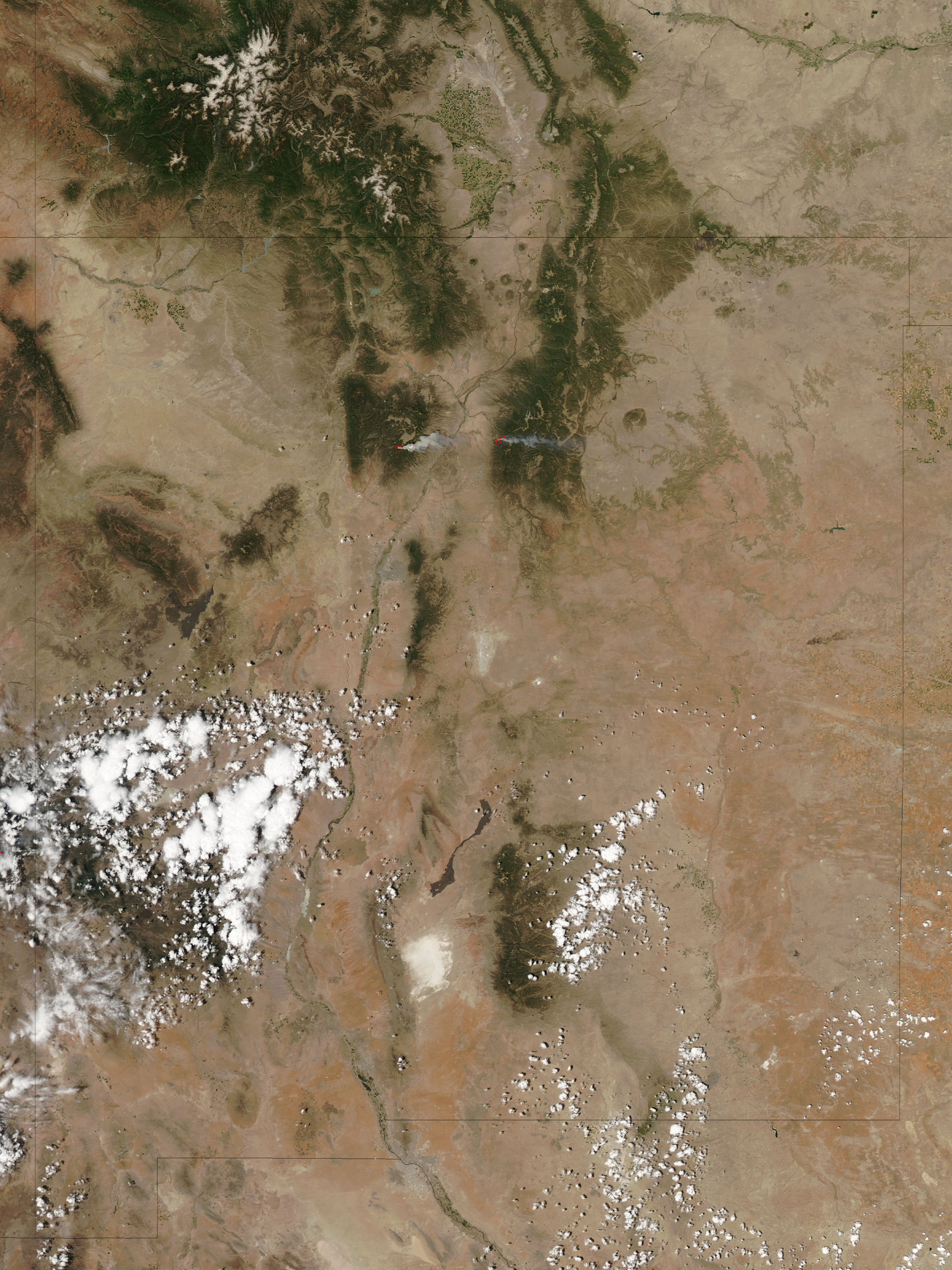
Click to enlarge. Las Conchas fire, photographed by NASA satellite, June 26, 2011.
Here is the caption provided by NASA for the photo above:
==========================================
High temperatures, low humidity, and strong winds allowed the Los Conchas Fire, burning near Los Alamos, New Mexico, to grow very quickly on June 26, 2011. The Moderate Resolution Imaging Spectroradiometer (MODIS)on NASA’s Aqua satellite captured this image about an hour and a half after the fire started. Within that short time, the fire had already become intense enough to send a towering plume of smoke east over Los Alamos, about 12 miles (19 kilometers) to the northeast. The active fire region is outlined in red.
By the morning of June 27, the fire had burned 43,597 acres (17,643 hectares or 176 square km), bringing down power and phone lines. The fire forced about 100 people out of their homes in the communities of Cochiti Mesa and Los Conchas and closed Bandelier National Monument and Los Alamos National Laboratory. As of about 10 a.m. local time, the fire was about a mile from the southwest boundary of the lab.
The image also shows the smaller Pacheco Fire burning in the Santa Fe National Forest east of the Rio Grande. The Pacheco Fire started on June 18 and has burned 9,334 acres (3,777 hectares or 38 square km).
Download large image of the photo above (2 MB, JPEG)
=================== Update at 9:10 p.m. MT, June 28, 2011:
This new map of the Las Conchas fire includes satellite data collected at 3:50 p.m. MT on Tuesday. The recorded heat showed comparatively little growth, with some additional acres on the northeast corner and also some on the southwest side.
As expected, the weather on Tuesday was less extreme than on Sunday and Monday, with afternoon winds recorded at the Tower weather station (east of the fire) southwest at 8-18 mph, with gusts at 19-34. The relative humidity bottomed out at 8% with a cloud cover shading the fire for much of the afternoon.
The forecast for Wednesday at Los Alamos is for a high temperature of 87, RH of 14%, and southwest winds increasing throughout the day, from 8-12 mph in the morning to 22 mph by 6 p.m. — suitable weather for significant fire spread, but not as extreme as on Sunday and Monday.
Click to enlarge. Las Conchas fire map showing heat detected by satellites at 3:50 p.m. MT, 6-28-2011. The red areas were actively burning at that time, while the yellow was within the last 12 hours, and the black was within the last 24 hours. MODIS
========================
Update at 12:25 p.m. MT, June 28:
At a news conference that started at 12:10 p.m. today, Doug Tucker, the Chief of the Los Alamos Fire Department, said two incident management teams either are or will be managing the fire, and that an Area Command Team has been ordered which will coordinate resources, establish priorities, and supervise the IMTeams. (Note: this was confirmed by New Mexico Fire Information.) The Chief said the fire started near a power line, but the cause and origin are still under investigation.
Tucker said that since the Cerro Grande of 2000, a great deal of vegetation management has been conducted in Los Alamos to make the structures and facilities more fire resistant than 10 years ago when over 280 homes were destroyed or damaged and 40 Los Alamos National Laboratory structures burned. The Chief said the city is now qualified as a “Firewise Community”, which is a remarkable change from 10 years earlier when the structures were extremely vulnerable to wildfire.
Tucker said the numerous barrels of stored radioactive waste at the Laboratory are surrounded by bare mineral soil or asphalt and there little chance that the fire could impinge on the barrels. The operations manager of the Lab said that if a wildfire does approach the radioactive materials they have equipment on site that will cover it with foam, further protecting it from fire.
A live camera is available at Pajarito Mountain ski area.
============================ Update at 10:18 a.m. MT, June 28, 2011:
New Mexico Fire Information has posted more information about the Las Conchas fire near Los Alamos. The size is now 60,740 acres, according to data from an infrared mapping flight at 11:13 p.m. June 27. They have a map of the fire, but the resolution is too poor to determine who produced it.
InciWeb has very outdated information that is at least 24 hours old, far too old for a 60,740-acre fire that is causing evacuations. And they have no downloadable maps or Google Earth fire perimeters posted. Hopefully the incident management team will get organized and provide better information than the Wallow fire teams did during their first week in Arizona.
The Southwest Coordination Center has posted information about the impacts of the smoke from the Las Conchas and Pacheco fires.
============================
Updated at 9:05 a.m. MT, June 28, 2011
Smoke from Las Conchas fire 6-27-2011. Credit: Los Alamos National Laboratory
The Las Conchas fire, pushed by strong winds, burned closer to the city of Los Alamos and the Los Alamos National Laboratory on Monday and Monday night. The fire crossed Highway 4 and continued for almost 5 miles north of the highway on the west side of the city of Los Alamos. It crossed to the west side of the East Fork of the Jemez River. Continue reading “Las Conchas fire threatens Los Alamos”
Bequi Livingston and Gary Luce have written an interesting analysis following two firefighter entrapments that occurred within 45 days of each other on two separate wildfire incidents on the Coronado National Forest in Southern Arizona.
Update at 5:40 p.m. MT, June 27, 2011: Replaced one of the maps generated by MODIS (the “overview” map) that had an error, showing the fire perimeter too far to the east.
=============================
Update at 3:20 p.m. MT, June 27, 2011:
We added more current, easier to see maps and links to live cameras:
Click to enlarge. Las Conchas fire mapped by Infrared flight, overview 0309 6-27-2011. MODIS/USFS


