The fire has burned 569,000 acres in Northern California
2:07 p.m. PDT August 16, 2021
Map of the Dixie Fire. The white line was the perimeter at 11:30 p.m. PDT August 15, 2021. The red dots represent heat detected by a satellite at 3:34 a.m. PDT Aug 16, 2021.
The heavy smoke layer that we have seen for days continued Sunday night to dampen fire activity on the Dixie Fire between Chester and Susanville, California. But on Monday Red Flag Warnings are in effect for critical fire weather conditions — 22 mph west-southwest winds gusting to 30 mph along with temperatures in the triple digits with relative humidity in the low teens. This could increase fire activity, pushing it to the east-northeast.
The Hot-Dry-Windy Index for the area on Monday is far above the 95th percentile. By Wednesday it will drop to around the 50th percentile before rising to around the 90th on Friday. The Hot-Dry-Windy Index is a prediction of potential fire spread. It is described as being very simple and only considers the atmospheric factors of heat, atmospheric moisture, and wind. To be more precise, it is a multiplication of the maximum wind speed and maximum vapor pressure deficit in the lowest 50 or so millibars in the atmosphere. It does not consider fuel moisture.
(To see all articles on Wildfire Today about the Dixie Fire, including the most recent, click HERE.)
Hot-Dry-Windy Index for the area of the Dixie Fire Monday, August 16, 2021.
On Sunday the most active portions of the fire were:
Northwest side as it continues to spread through Lassen Volcanic National Park.
North-central, northeast of Chester and northwest of Westwood.
Mountain Meadows Reservoir, to the west and northeast.
West of Antelope Lake, where the fire has moved into the 2019 Walker Fire.
Damage assessments are ongoing on the Dixie Fire. To date the teams have documented as destroyed, 633 residences and 134 commercial structures. Maps are available showing the status of structures.
The fire has burned 569,000 acres.
Resources assigned to the incident include 569 fire engines, 194 water tenders, 89 hand crews, and 198 dozers for a total of 6,579 personnel.
Map of the Twentyfive Mile Fire at 5 p.m. PDT Aug. 16, 2021. The red shaded area represents intense heat. Scroll down for a map with a wider view.
A mapping flight of the Twentyfive Mile Fire at 5 p.m. Monday determined the fire had burned 4,262 acres and had spread into the footprint of the 2015 First Creek Fire.
Fire personnel reported that they expect the strong northwest winds predicted through Tuesday will push the fire unchecked to the south and east toward the community of Chelan. Lack of resources will hamper any ability for containment, they said.
A Type 3 Incident Management Team is in place and a Type 2 team has been ordered and will arrive on Wednesday.
11:53 a.m. PDT August 16, 2021
The Incident Management team released information about the Twentyfive Mile Fire at 11:00 Monday morning. They estimate the size at 4,000 acres, up from the 2,000 estimated Sunday evening. One structure has been destroyed and 135 are threatened.
The incident is under the joint jurisdiction of the Okanogan-Wenatchee National Forest, Washington Department of Natural Resources, and Chelan County Fire District 7. A Type 3 Incident Management Team led by Incident Commander Escobar assumed command at 6:00 a.m. today. Additional resources are continuing to arrive to supplement the 150 on scene.
Aircraft will be using Lake Chelan as a water source for dipping and scooping, so boaters are advised to give them a wide berth.
9:49 a.m. PDT August 16, 2021
3-D map of the Twentyfive Mile Fire looking southwest at 2:41 a.m. PDT August 16, 2021.
A fire reported at 3:45 p.m. Sunday near Lake Chelan in Washington quickly grew to about 2,000 acres. Satellite data indicates that it is burning on both sides of Twentyfive Mile Creek; hence the name, Twentyfive Mile Fire. (See the map above.)
The blaze is on the west side of Lake Chelan at the north end of South Lakeshore Road 14 miles northwest of Chelan and 7 miles northwest of Manson near Grouse Mountain Campground.
Satellite heat sensing data shows that it has burned close to Lake Chelan. With Sunday’s fire behavior described by personnel on scene as “extremely long-range spotting”, it is not inconceivable that the Twentyfive Mile Fire could spot across mile-wide Lake Chelan — IF it was burning very intensely with a strong south or west wind. At 2:41 a.m. satellite data showed the fire was about two miles by two miles.
Map of the Twentyfive Mile Fire. The red dots represent heat detected by a satellite at 2:41 a.m. PDT Aug 16, 2021. North is at the top of the map.
Mandatory “leave now” evacuations are in effect. Chelan County has a map showing the areas for “level 3” (go now), “level 2” (get set to leave immediately if necessary), and “level 1” (get ready to leave). Yes, the evacuation nomenclature is confusing.
A weather station that may be within the fire perimeter (WAOWF QD 1702) recorded 5 mph winds out of the north and northwest Sunday with 8 to 18 mph gusts while the relative humidity was in the teens and the temperature was in the 90s. At 8:30 Monday morning it was 71 degrees, 37 percent RH, with very little wind. The forecast for the fire area Monday afternoon calls for 13 mph winds out of the northwest gusting to 20 mph, 80 degrees, and 30 percent RH. On Tuesday the northwest winds will increase to 16 mph gusting at 22 to 30, but with the RH around 40 percent and an 18 percent chance of rain Monday night and Tuesday.
There are two other fires from 2013 and 2014 with similar names as you can see on the map below. The current Twentyfive Mile Fire started in an area that has not burned in at least 21 years. There were two large fires in 2004 to the north and south. On the southeast side is the footprint of the 2015 First Creek Fire which it may have already burned into.
Fire history since 2000, vicinity of the Twentyfive Mile Fire
Air quality (ozone, PM2.5, andPM10) at 8:01 a.m. PDT Aug 15, 2021. AirNow.gov.
The areas with the worst air quality and smoke Sunday will be Northern California, Southern Oregon, Northeast Washington, Idaho, Northern Utah, Northern Nevada, Northwest Wyoming, and Montana — basically the northwest quarter of the country.
Above is the air quality in the Western United States (ozone, PM2.5, and PM10) at 8:01 a.m. PDT August 15, 2021. By AirNow.
Below is the forecast for near-surface wildland fire smoke at 1 p.m. PDT Sunday August 15, 2021.
Forecast for near surface wildland fire smoke at 1 p.m. PDT August 15, 2021. NOAA.
Map of the Parleys Canyon Fire at 9 a.m. MDT Aug. 15, 2021. Mapped by Incident Management Team.
More accurate mapping Sunday found that the Parley’s Canyon Fire east of Salt Lake City has burned 619 acres, much lower than the earlier estimate. Firefighters reported at about 2 p.m. that the spread of the fire has been “minimal” so far on Sunday.
7:37 a.m. MDT August 15, 2021
Map showing heat detected by satellites on the Parley’s Canyon Fire at 4:02 a.m. MDT Aug 15, 2021.
After sunset on Saturday the spread of the Parley’s Canyon Fire slowed after an aggressive attack by firefighters from the air and on the ground. Sunday morning fire authorities said night crews reported there was little overnight growth. There is no official accurate mapping yet but they estimate it has burned 1,500 acres.
The fire is east of Salt Lake City on the south side of Interstate 80, 10 miles east of I-215 between Lambs Canyon Road and Summit Park. It is approximately 4 miles west of Kimball Junction and 9 miles northwest of Park City.
The Northern Utah Type 3 Incident Management Team has assumed command of the 120 personnel on scene. Approximately 2,000 structures are threatened.
The weather forecast for the fire area Sunday could be concerning for firefighters. The elevation in the fire area ranges from 6,500 to over 8,000 feet. For the higher slopes the prediction is for 10 mph winds out of the west beginning at 9 a.m. increasing after noon to 14 mph from the northwest. The relative humidity will be around 20 percent with the temperature in the high 70’s at 8,000 feet. There will be 50 percent cloud cover decreasing to 10 percent after 3 p.m. After sunset the wind will slow to 7 mph but will shift to come out of the southeast after 11 p.m.
3-D map looking east, showing heat detected by satellites on the Parley’s Canyon Fire at 4:02 a.m. MDT Aug 15, 2021.
The video below shows a retardant drop by a single engine air tanker and one by Bomber 210, a 737 on loan from the New South Wales Rural Fire Service in Australia.
Parley’s Canyon Fire. Photo by Utah Highway Patrol.
Interstate 80 at the Parley’s Canyon Fire east of Salt Lake City has reopened in both directions, but with lane restrictions.
Map showing the location at which the Parley’s Canyon Fire started August 14, 2021.
The Parley’s Canyon Fire spread rapidly after it started Saturday at about 3 p.m. on the south side of Interstate 80, 10 miles east of I-215. The fire is between Lambs Canyon Road and Summit Park.
Photo by Air Attack.
The US Forest Service reported at 3:20 p.m. Saturday that I-80 was closed in both directions. At that time the aircraft responding included 2 Very Large Air Tankers, 4 Large Air Tankers, 6 Single Engine Air Tankers, helicopters, and numerous ground resources from state and federal agencies.
Utah Fire Information said at about 4:45 p.m. MDT the fire had burned an estimated 2,500 to 3,000 acres. The areas under evacuation orders included Summit Park, Pine Brook, Lambs Canyon, and Mill Creek affecting 6000-8000 homes. They said the fire was caused by a malfunctioning catalytic convertor which ejected hot particles along the highway. The photo above appears to show at least two origin locations which is consistent with that type of incident.
A Type 2 Incident Management Team has been requested, but that has to be approved first by the National Multi-Agency Coordinating Group in Boise under a new policy created July 18. A Type 3 IMT was ordered earlier.
Satellite photo showing heat and smoke on the Parley’s Canyon Fire detected by a satellite.The 3-D map looking east shows the origin area of the Parley’s Canyon Fire. It started on the south side of I-80 and initially spread uphill to the south.
The Modular Airborne FireFighting Systems have not changed much since the 1970’s
Training MAFFS personnel, Boise, April 20, 2017. Photo by Bill Gabbert.
(This article was first published on Fire Aviation)
This wildfire season in the 48 contiguous states so far is turning out to be one to be remembered. Today nearly 25,000 personnel are working on suppressing 93 large fires across 14 states. In addition, another 47 fires are being managed under a strategy other than full suppression.
In May the Forest Service said they would have 34 large air tankers (LAT) if needed — 18 on Exclusive Use Contracts guaranteed to work, plus 8 “surge” LATs guaranteed to work for a shorter period of time, and another 8 on Call When Needed (CWN) status. Of those 16 surge and CWN aircraft, only 5 could be produced in July. One LAT, a 737 owned by the New South Wales Rural Fire Service in Australia, has flown across the Pacific to lend a hand.
On July 14 the National Interagency Fire Center upgraded the Preparedness Level to 5, which was the earliest date in 10 years.
There is a shortage of Incident Management Teams (IMT). All available Type 1 IMTs, 14 of them, are assigned, plus 24 Type 2 IMTs. The National Multi-Agency Coordinating Group (NMAC) decreed on July 18 that all requests for Area Command, National Incident Management Organization (NIMO), Type 1, and Type 2 IMTs must be approved by them.
All of the LATs available and under contract to the US Forest Service are being used. There are no more. So what’s left?
The FS frequently says they can call on eight military C-130’s equipped with 3,000-gallon Modular Airborne FireFighting Systems (MAFFS). Since the 1970s the agency has committed a great deal of time and taxpayer funds coordinating with the Defense Department, annual training and certification, and when activated, paying the large costs associated with operating the aircraft. Each requires a seven-person crew, additional support personnel, and often a third conventional C-130 for every two MAFFS that are activated. They have not changed much since the 1970s. Instead of spraying retardant out of the lowered cargo ramp it goes out the left side troop door. They have two onboard air compressors that occasionally work, but still rely on huge industrial grade compressors on the ground to pressurize the spray system.
MAFFS training, Boise, April 21, 2017. Photo by Bill Gabbert.
Until a couple of days ago only five of the eight MAFFS had been working for the last several weeks. Late this week a sixth was brought on. Four military bases each have two MAFFS and are responsible for having personnel available to activate them in less than 48 hours. Two National Guard bases have activated only one. Wyoming’s 153rd Airlift Wing and California’s 146th Airlift Wing each have one parked.
During a virtual meeting July 27 with Western Governors to discuss wildfire preparedness, President Joe Biden was told that their states need more aviation resources, help with obtaining aviation fuel, and more boots on the ground.
On August 4 Agriculture Secretary Tom Vilsack said the Governors’ request for additional aviation resources, “… Came to my desk. One of the challenges we’re working on right now is making sure we get the Defense Department personnel necessary to fly the planes. So sometimes it’s not even the planes, it’s the pilots, the people who know how to fly these planes…I was given instructions to… make sure we have the people in the planes to fly them.”
The Secretary was most likely referring to the MAFFS. But it is the Secretary of Defense who needs to take action to provide flight crews.
OPINION
The Forest Service was only able to acquire, to help protect our homeland from wildfires, 31 percent of the CWN aircraft they said they expected, and 75 percent of the MAFFS.
If what we’re doing is not working, will continuing to do the same thing bring different results?
If the Air Force can’t 100 percent support the MAFFS, an evaluation of the program by a completely independent group is warranted. Is there a better way to provide this service, or should a MAFFS 3.0 be designed and built? The analysis must be configured to insure that the FS does not have the ability to skew the objectives or the findings to fit any preconceived biases. And I’m not recommending a multi-million-dollar “study” that could take years. Simply get 8 to 10 subject matter experts in the same room to come up with a plan.
The President needs to order the Department of Defense to take care of two important issues:
Staff the MAFFS with qualified personnel so the equipment can be used to help protect our homeland.
Order the Air Force to complete the conversion of the seven Coast Guard C-130’s into air tankers. They have been slow-walking this project and the $150 million Congress appropriated to get it done since December, 2013. Coulson Aviation has converted a C-130 into an air tanker in six months. It may not have required a new wing box, but eight to ten years is not reasonable.
If the President does nothing to kick the Air Force in the butt, Congress should hold hearings.
Apparently no viable contingency plans have been developed for this shortage of LATs by NMAC, Interagency Airtanker Board, and the leaders in the FS, National Park Service, Fish and Wildlife Service, Bureau of Indian Affairs, and the Bureau of Land Management.
Not surprisingly, having only 18 LATs on exclusive use contracts is a strategy doomed to failure. That number is 26 fewer than were on EU contracts in 2002. Is this progress?
One of the lessons learned this year and others like it, is, Congress must appropriate adequate funds for the five land management agencies to pay firefighters a living wage, conduct more prescribed fires, and have at least 40 large air tankers and 50 large Type 1 helicopters on exclusive use 10-year contracts instead of 1-year contracts.
We often say, “air tankers don’t put out fires”. Under ideal conditions they can slow the spread which allows firefighters on the ground the opportunity to move in and suppress the fire in that area. If the winds are too strong or firefighters are not nearby, in most cases the flames will often burn over, through, or around the retardant. During these unprecedented circumstances brought on by the pandemic and drought we need to rely much more on aerial firefighting than in the past. And there must be an adequate number of firefighters available to supplement the work done from the air. It must go both ways. Firefighters in the air and on the ground supporting each other.
For new fires that have a suppression objective, attacking them with overwhelming force from both the ground and the air can sometimes keep a small fire from becoming a megafire that burns homes and threatens the safety of our citizens.
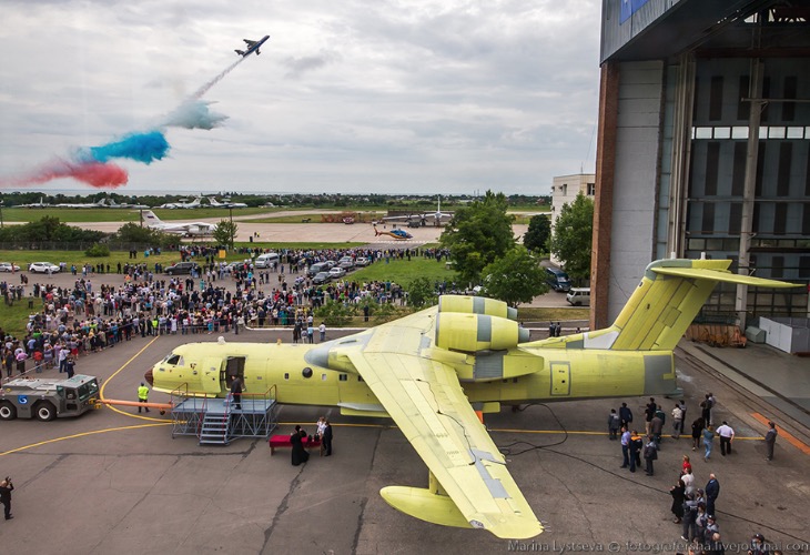
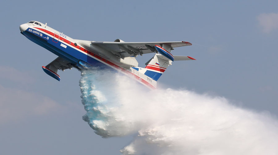
A Be-200ES rolls out for the public while another makes a demonstration water drop. May 30, 2016. Beriev photo.
(This article was first published on Fire Aviation)
The Russian Defense Ministry has confirmed that a Beriev Be-200 air tanker crashed in Turkey Saturday. There was no immediate word on the condition of the five Russian army personnel and three Turkish officers that were on board.
A low resolution video (below) showed what may have been the aircraft dropping water then continuing toward what appeared to be rising terrain.
The aircraft was being leased from Russia and went down near Adana, the Russian Defense Ministry said.
The Turkish state news agency Anadolu reported that rescuers who rushed to the scene had video footage showing plumes of smoke from the site.
Beriev began manufacturing the Be-200 in 2003. It is one of the few purpose-built air tankers, designed primarily for fighting wildland fires. The aircraft can land or take off on water or land, and the firefighting version can scoop water to refill its 3,000-gallon tanks. It can be converted to haul passengers or serve as a search and rescue aircraft, landing on water to retrieve victims if necessary.
Roughly 10 years ago U.S. Forest Service employees traveled to Taganrog, Russia the home base of the Beriev company, to conduct tests to determine if the Be-200 could be approved by the Interagency Airtanker Board (IAB). At the time, we heard unofficial reports that it met the criteria for water-scooping air tankers, but tests were not completed for dropping fire retardant.