South Canyon fire, 1994

Posted on Categories Uncategorized

Another reminder–

Today, July 6 is the 14th anniversary of the South Canyon fire near Grand Junction, CO.

From the IAWF Wildland Fire Event Calendar:

On the afternoon of July 6, 1994, the South Canyon fire near Grand Junction, CO spotted across the drainage and beneath firefighters, moving onto steep slopes and into dense, highly flammable Gambel oak. Within seconds, a wall of flame raced up the hill toward the firefighters on the west flank fireline.

Failing to outrun the flames, 12 firefighters perished. Two helitack crew members on top of the ridge also died when they tried to outrun the fire to the northwest. The remaining 35 firefighters survived by escaping out the east drainage or by seeking a safety area and deploying their fire shelters.


For more information, the Lessons Learned Center has the investigation report. It is a large file, about 4 MB.

Eureka Reporter article on Siege of '08

Posted on Categories Uncategorized

The newspaper article for which I was interviewed appeared in the Eureka Reporter and on their web site today. Here is how the article begins:

The hundreds of fires that have scorched California during the past two weeks have burned more than 520,000 acres. That already tops last year’s disastrous Southern California wildfires that burned 500,000 acres from Santa Barbara County to the Mexico border, which started Oct. 20 and burned until Nov. 9.

Hot weather, winds and a drought contributed to those fires, while this year’s wildfires in California’s remote and rugged terrain were started by unusual early-summer lightning storms that struck on June 20.

Already entrenched in an epic budget battle in Sacramento, state officials have had to dig deep to free up the money and resources to battle the blazes that have also brought federal support and financial aid from disaster declarations for several counties.

The Eureka Reporter takes a deeper look into how the fires, which some are already comparing to the worst fires in California’s history, are impacting residents financially and personally.

CA: Piute fire July 6

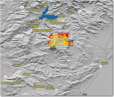
The fire is 21,478 acres and is 26% contained.

From Kern County FD:

On Saturday, the fire moved actively toward the east and northeast driven by strong southwest winds and further growth is expected in the same area today. The fire perimeter now extends into the BLM Bright Star Wilderness. The fire also continues to move slowly down slope along the western and northern perimeters. Firefighters plan to burnout fuels along the southeastern fire line. Yesterday, the fire increased 2,468 acres.

There was active burning on the eastern side as the head of the fire fingers into sparse desert fuels in the Bright Star Wilderness. The fire has spread into Cortez and Bright Star Canyons. All structures continue to be protected.

Hand crews and dozers are constructing indirect fire lines on the northern and western ridges. Firefighters continue to reinforce fire line along the flanks of the southern perimeter.

Precautionary evacuation notices were delivered to residences in the Kelso Valley area by the Kern County Sheriffs Office and Search and Rescue Team.

The map below shows heat, in red, orange, and black, detected by satellites last night, with the red areas being the most recently burned. The yellow lines are the perimeters uploaded by the incident management teams yesterday. Click on the map to see a larger version.

California: Basin fire, July 6

Posted on Categories Uncategorized

The Basin Complex and the Indians fires have now been combined into a unified command.

The fire activity on the Basin fire was slowed somewhat yesterday along the coast under the influence of the marine layer, but it was very active on the north and south sides. The fire is 71,285 acres and is 5% contained.

South side: Firefighters continue to make progress on the fireline going down the ridge from the North Coast Ridge trail south towards the Square Black Rock south of Esalen. Slow progress is still occurring on the Ridge trail toward the Rodeo Flats Trail, which will connect the fire to the Indians fire. To improve radio communications, a radio repeater will be placed on a boat.

North side: Last night firefighters were expected to begin firing from Andrew Molera State Park north along the Old Coast Road towards the Little Sur river, and eventually to a dozer line on Mescal Ridge. The fire last night was about 2 miles south of the ridge. If this plan works, and subsequent firing along Mescal Ridge is successful, this would tie off the northwest corner of the fire. Yesterday the DC-10 air tanker made some drops on Mescal Ridge.

East side: There was some activity on the east side, but it is still 1.5 to 2 miles away from Tassajara.