Report on fireground noise and digital radios

Posted on Categories Uncategorized

Fairfax, Va., June 30, 2008… The International Association of Fire Chiefs Digital Project Working Group today released its Interim Report and Recommendations: Fireground Noise and Digital Radio Transmissions. This report culminates a year’s work with public-safety organizations, manufacturers and the laboratory services of the federal government to determine the extent of radio transmission problems associated with fireground noise.

To review the report, go to DPWG Interim Report on the IAFC website. Two important companion reports also are posted on the site: the IAFC Portable Radio Best Practices presentation; and the National Telecommunications & Information Administration report, Intelligibility of Selected Radio Systems in the Presence of Fireground Noise: Test Plan and Results.

The intent of the IAFC interim report is to alert the fire service that noise on the fireground can interfere with intelligible radio communications. The report is organized into sections that provide background on the issue, the steps the Digital Project Working Group took to investigate the problem in an objective laboratory setting, the results of the testing and corresponding analysis and recommendations, and best operational practices.

Firefighters' liability

The Bozeman Daily Chronicle has a lengthy article about the modern-day realities of fighting fire in our liability-ridden, wildland-urban interface choked climate today. Here is a brief excerpt.

Dick Mangan has fought fires around the country for 40 years and can wear a number of hats: operations chief, planning chief and safety officer.

He’s also past president of the International Association of Wildland Fire, a professional association with thousands of members. He knows his business.

But these days, when he goes on a fire, his wife issues a warning.

“My wife tells me, ‘Don’t do something stupid. I don’t want to lose the house,’” he said.

Like many fires bosses, Mangan has a new concern: personal and legal liability if something goes wrong and lives or property are lost.

The issue got serious in 2006, when Ellreese Daniels was charged with four counts of involuntary manslaughter and three other felonies, five years after four people under his command died in the Thirtymile fire in Washington.

The charges were later reduced and Daniels has pleaded guilty to two misdemeanor counts of making false statements to investigators. His sentencing is scheduled for July 23.

But the event cast a pall in command tents at fire camps across the nation.

“It puts a very, very dark cloud over everybody in the fire community,” said Mangan, of Missoula.

Photo of Dick Mangan, by Bill Gabbert, at the 2006 Wildland Fire Safety Summit, Pasadena, CA, put on by the International Association of Wildland Fire

Smoke–nationwide (almost)

Posted on Categories Uncategorized

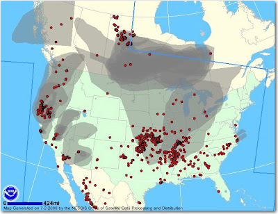
On June 28 we posted a map that showed smoke plumes from California reaching east all the way to Missouri. Today there is even more smoke across the U.S. but most of it is not from the California fires. It originates in Canada, California, Kansas, Oklahoma, Arkansas, and Mississippi.

On the map below, the red dots are fires and the gray areas are smoke.

California: Piute fire

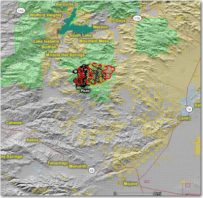
The Piute fire south of Lake Isabella was very active on Tuesday.

Information about the fire from South Zone, at 1800, July 1:

11,514 acres, 11% contained. Extreme conditions led to high rates of spread and torching. This resulted in significant eastward movement in Division X. The fire remained active throughout the Operational Period. Long-range spotting continues to be a dominant factor in fire progression. Growth potential continues to be high.

The map below shows heat, in red, orange, and black, detected by satellites last night, with the red areas being the most recently burned. The yellow lines are the perimeters uploaded by the incident management teams yesterday. Click on the map to see a larger version.

California: Basin fire update, July 2

Posted on Categories Uncategorized

The Basin Complex near Big Sur continues to spread on the north, east and south sides. Firefighters are requiring a mandatory evacuation on the west side of the fire for both sides of Highway 1 from Partington Ridge Road to 1 mile south of Limekiln State Park effective at 5:00 p.m. Tuesday, July 1, to provide for the safety of residents and firefighters while crews conduct a burning operation that will reinforce containment lines on the south end of the fire.

One place they are conducting firing operations is on the south side along the North Coast Ridge Trail. They are burning along a fireline that will connect the Basin complex to the Indians fire along that trail and the Rodeo Flats trail.

Here is the latest map, showing heat detected by satellites (in black, orange, and red), and the perimeter (in yellow) uploaded by the incident management team. Click on it to see a larger version.


The firing operation on the Indians fire is complete, and official containment is predicted for July 3.