An association that represents about 30 vendors who supply shower and catering services at wildland fires is seeking a modification of certain hours-of-service rules when they en route to a fire. These companies provide hot showers and on site meals for wildland firefighters while they are working on fires, usually in the Western United States.
The National Mobile Shower & Catering Association (NMSCA) submitted to the Federal Motor Carrier Safety Administration (FMCSA) a request to modify the Federal hours-of-service (HOS) rules for their commercial motor vehicle drivers while they are traveling to an assignment under a Resource Order:
Extend the 14-hour duty period to no more than 16 hours;
Not include “waiting time” while not performing duties in the calculation of the 16-hour duty period;
Not comply with the minimum 30-minute rest break provision;
Extend the maximum 60 hours on duty in any 7-day period to 80 hours on duty in any 7-day period;
Extend the 11 hours of driving time to 12 hours; and,
Extend the “8 days in 30” exception in the electronic logging device (ELD) rule to “12 days in 30.”
The FMCSA is requesting public comment on the NMSCA application for exemption, which must be received on or before December 27, 2018. Instructions for commenting are at the Federal Register.
Thanks and a tip of the hat go out to Bob. Typos or errors, report them HERE.
Firefighters battle the wildfire near Deepwater in Queensland. F&ES photo.
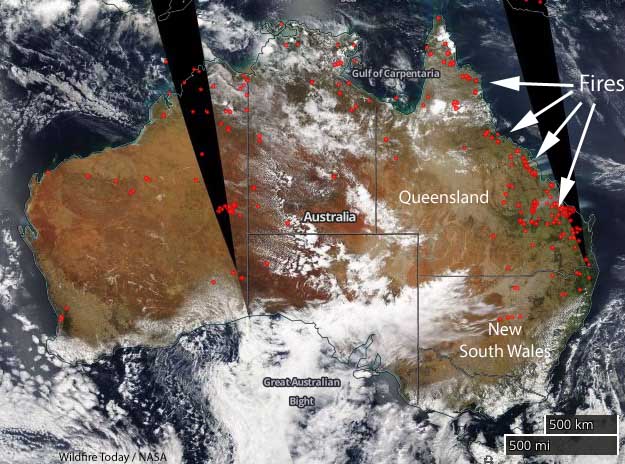
Firefighters and residents of Queensland in northeast Australia are figuring out how to deal with unprecedented conditions — 135 wildfires all burning at the same time during very hot, windy conditions. Fire officials have elevated the fire danger to a level previously unseen in the state, “catastrophic”. Evacuations are underway in several communities.
The Queensland Bureau of Meteorology wrote in their tweet with this image: “Fire ? Danger Ratings have reached Catastrophic for the first time in #Queensland due to the combination of a very dry, hot airmass and strong, gusty westerly winds. Follow the advice of @QldFES during these extremely challenging fire weather conditions.
This is supposed to be the wet season in Queensland.
Katarin Carroll, Commissioner of Queensland F&ES at briefing November 26, 2018.
In a public briefing Wednesday evening, Katarin Carroll, Commissioner of Queensland Fire and Emergency Services, said they saw this coming and began ordering additional firefighting resources from New South Wales and other states last week. The forecast calls for the extraordinarily hot and dry weather to continue in Queensland through Tuesday, December 4. Meanwhile farther south, New South Wales is receiving large quantities of rain, causing flooding in some areas.
This is normally the dry season in NSW.
In the video below Annastacia Palaszczuk, Premier of Queensland, begins the November 26 evening briefing about the fire situation, followed by Commissioner Carroll.
Wildfires are affecting a number of areas in Queensland, including Campwin Beach, Sarina Beach, Deepwater, Baffle Creek, Rules Beach, Oyster Creek, Caloundra, Gracemere, Eungella, and Kowari Gorge.
Satellite photo of smoke from the fires in Queensland, Australia, November 26, 2018. Since then clouds have made it difficult to obtain a good image of the area. NASA
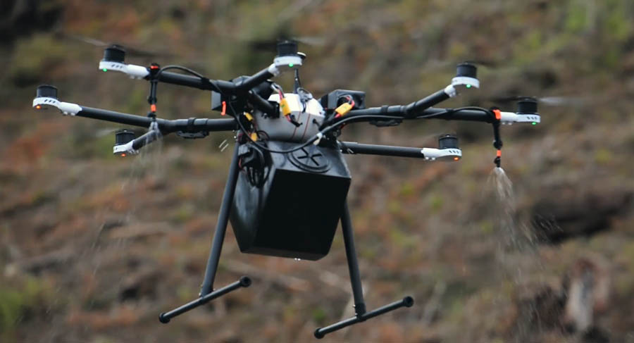
A startup company is building a drone system to spray pesticides and replant trees
A DroneSeed drone applying a herbicide. Screenshot from DroneSeed video.
(This article was first published on Fire Aviation)
Replanting trees after a wildfire or logging operation is an extremely labor intensive and expensive task. Carrying a bag of seedlings and using a dibble bar or shovel across steep debris-covered terrain can wear out a human.
A new company, DroneSeed, has a solution. Use machines. They are designing a system around a swarm of drones that can plant tree seeds in places where they have a decent chance of survival. First they survey the area with a drone using lidar and a multispectral camera to map the terrain and the vegetation. Software then identifies the areas that have invasive species or other plants the landowner wants to eliminate and then a drone applies herbicide to only the patches that need it, rather than dumping pesticide over the entire landscape.
According to an article at TechCrunch, DroneSeed is still fine tuning the seed dispersing system, but the next step is to use artificial intelligence to sort through the mapping data to find microsites where a dropped seed is most likely to germinate.
Using a concept that has been around for a long time, they will coat the seeds with substances that will enhance its survival chances. The article explained that the company is very reticent to detail exactly what will be applied to the seed. In agriculture, seeds are often coated with polymers, fertilizers, or fungicides. Polymers can improve the flowability and plantability — if the weather is hot and humid, cool and damp, or dry — to get consistent seed drop.
One issue DroneSeed appears to be concentrating on is deterring animals from eating or removing the seeds. They are looking at adding capsaicin, a chili pepper extract, to the coating. A fertilizer, if included, would wash off during a rain and then supply nutrients to the seed as it germinates.
The drones they are using are off the shelf aircraft that DroneSeed guts and converts into a machine that fits their missions. They are referred to as “heavy lift” drones since they weigh more than the 55-pound maximum for more conventional drones. The FAA limits heavy lifts to 115 pounds. The company says they are the first and only company the FAA has approved to use drone swarms to dispense agricultural payloads (fertilizers, herbicides, and water).
The FAA classifies this exception as “precedent setting”, referring to the exceptional lengths DroneSeed has gone to prove out its ability to scale operations to larger payloads for multiple concurrent flights.
As you can see in the video below, the drones are used in swarms, with five to six drones being able to equal the production of one helicopter when spraying herbicides.
DroneSeed has worked for three of the five largest timber companies since 2017 spraying herbicides, but they are just getting into the tree seeding game. They missed the prime planting season this year but were able to apply seeds to a few small sites and should be in a good position next year to show off their results.
A U.S. Border Patrol agent pleaded guilty to starting the Sawmill Fire southeast of Tucson by shooting at an exploding target
The U.S. Forest Service has released a video of the exploding target that started what became the 46,000-acre Sawmill Fire southeast of Tucson in 2017.
Border Patrol agent Dennis Dickey has pleaded guilty to starting the fire. He was holding an off duty party to celebrate his wife’s pregnancy at which the gender of his baby was revealed. He mixed colored powder into a Tannerite exploding target which would show blue or pink smoke when shot with a rifle. The target exploded as planned, revealing the blue powder, but it started what became the Sawmill Fire. A witness recorded video of the explosion.
A screenshot from the video below showing the exploding target that started what became the 46,000-acre Sawmill fire.
Agent Dickey set up the dangerous device at a location where it was surrounded by dry grass and mesquite trees. At the end of the video a voice can be heard shouting twice, “Start packing up!”.
The video obtained by the Arizona Daily Star from the U.S. Forest Service through the Freedom of Information Act is below.
One of the commenters where the video is posted on YouTube, wrote, “I feel bad for the poor baby boy who’s inheriting those genes.”
Agent Dickey said he attempted to put out the fire but when that failed, he reported it. At one point during the next week at least 799 firefighters were working to put out the fire, which ran up costs of approximately $8.2 million according to the May 5, 2017 national Situation Report.
On April 23, 2017, the day the fire started, the Hopkins weather station not far from where the fire began near Madera Canyon, recorded a high temperature of 80 degrees, 11 mph WSW winds gusting to 25, and 6 percent relative humidity. The weather station is at 7,100 feet and the location of the party where the fire started is most likely around 4,000 feet. If correct, this would put the temperature at the fire origin between 90 and 100 degrees.
A news release from the U.S. attorney’s office said Agent Dickey will make an initial payment of $100,000, then make monthly payments after that. According to the Arizona Daily Star and the Green Valley News, he agreed in court to pay $500 a month for the next 20 years, which adds up to $120,000, for a total of $220,000 including the first payment. He also will be sentenced to 5 years of probation and agreed to participate in a public service announcement with the U.S. Forest Service concerning the cause of the Sawmill fire.
Exploding targets consist of two ingredients that when mixed by the end user explode when shot by a high-velocity projectile. They have caused many fires since they became more popular in recent years, have been banned in some areas, and caused the death of one person. After the ingredients are combined, the compound is illegal to transport and is classified as an explosive by the Bureau of Alcohol, Tobacco, and Firearms.
The state has had unusually severe fire weather and more is in the forecast for the rest of this week
Satellite photo of Queensland, Australia, showing smoke from wildfires. Photo taken at 0600z Nov. 26, 2018.
(UPDATED at 8 a.m. PST November 27, 2018)
The siege of wildfires in Queensland, Australia continues with approximately 80 blazes burning across the state. This is normally the wet season there, but unprecedented warm, dry, windy weather has set up conditions ripe for large, rapidly spreading fires.
LEAVE NOW: Dalrymple Heights bushfire as at 12am Wed 28 Nov.Currently, as at 12am Wednesday 28 November, a large fast-moving fire is travelling in a south westerly direction towards Dalrymple Heights. It is currently impacting Snake Road and Chelmans Road. The fire could have a significant impact on the community. Fire crews are working to protect properties along Snake Road and Chelmans Road but firefighters may not be able to protect every property. You should not expect a firefighter at your door. Power, water, and mobile phone service may be lost.
LEAVE IMMEDIATELY: Deepwater, Baffle Creek, Rules Beach, Oyster Creek – bushfire as at 11.40pm Tues 27 Nov.Currently at 11.40pm Tuesday 27 November, an extremely large and intense fire is traveling in a south-westerly direction towards Muller Road. It is expected to impact Baffle Creek, Rules Beach and Oyster Creek in the coming hours. The fire is expected to have a significant impact on the community. All Deepwater, Baffle Creek, Rules Beach and Oyster Creek residents should evacuate in a westerly direction towards Miriam Vale using Tableland Road and Fingerboard Road. The crossing at Hills Road, Coast Road and Oyster Creek Road, Baffle Creek was under threat, but firefighters have managed to prevent the fire spreading to the crossing at this time.
(Originally published at 11:41 a.m. PST November 26, 2018)
The red dots represent heat detected in Australia by a satellite November 26, 2018.
Hundreds of residents have evacuated their homes in northeast Australia in the state of Queensland due to large wildfires. On Monday fire officials said a fire near Deepwater had burned 17,000 hectares (42,000 acres) and had a fire front 60 kilometers (37 miles)long.
Smoke from wildfires in Queensland, Australia photographed by a satellite November 26, 2018.
State Emergency Service volunteers have been knocking on doors to tell people to leave their homes in Deepwater, Baffle Creek, Rules Beach, and Oyster Creek.
The bushfire in the Deepwater area of Queensland. QF&E photo.
At 6:50 p.m. local time November 26, the dangerous and unpredictable fire was spreading in a south, south-west direction from Capricornia Drive and Pacific Drive at Deepwater towards Baffle Creek, Rules Beach and Oyster Creek. At that time it was impacting the Deepwater community and was expected to begin impacting Baffle Creek, Rules Beach and Oyster Creek in a few hours.
This is normally the wet season in Queensland, unlike areas farther south in New South Wales and Victoria.
“The central Queensland fire situation is unprecedented for its ferocity, the low humidity, the extreme heat and variable winds”, Annastacia Palaszczuk, the Premier of Queensland said. “Other fires and heat waves are a threat in other parts of our state.”
The temperature for the rest of this week at Baffle Creek, one of the areas being evacuated, will be about 10 degrees F (6 degrees C) warmer than normal for the date, ranging from 88 to 95 F (31 to 35 C), along with wind speeds exceeding 10 mph mostly out of the northeast.
“In this part of the world we have not experienced these conditions before,” Queensland Fire and Emergency Services Commissioner Katarina Carroll said on Monday. “It is unprecedented.”
For the first time a large air tanker is being used in Queensland. The 737 under contract with the New South Wales Rural Fire Service is helping out.
HEAVY DUTY SUPPORT!
For the first time in Queensland, a large air tanker or “LAT” is being used to fight bushfires. The water bomber can carry more than 15,000 litres of water in a single load. The giant plane will attack the fires at Deepwater near Agnes Water. pic.twitter.com/33B3w57Qbc
— Qld Fire & Emergency (@QldFES) November 26, 2018
Outbreak of #bushfires? across #Queensland, Australia?? today fanned by WSW dry winds out of the interior. As seen by Himawari-8?️with RAMMB Slider. #fires pic.twitter.com/boxRlor4jM
By mid-century western wildfires could increase 200% to 600%
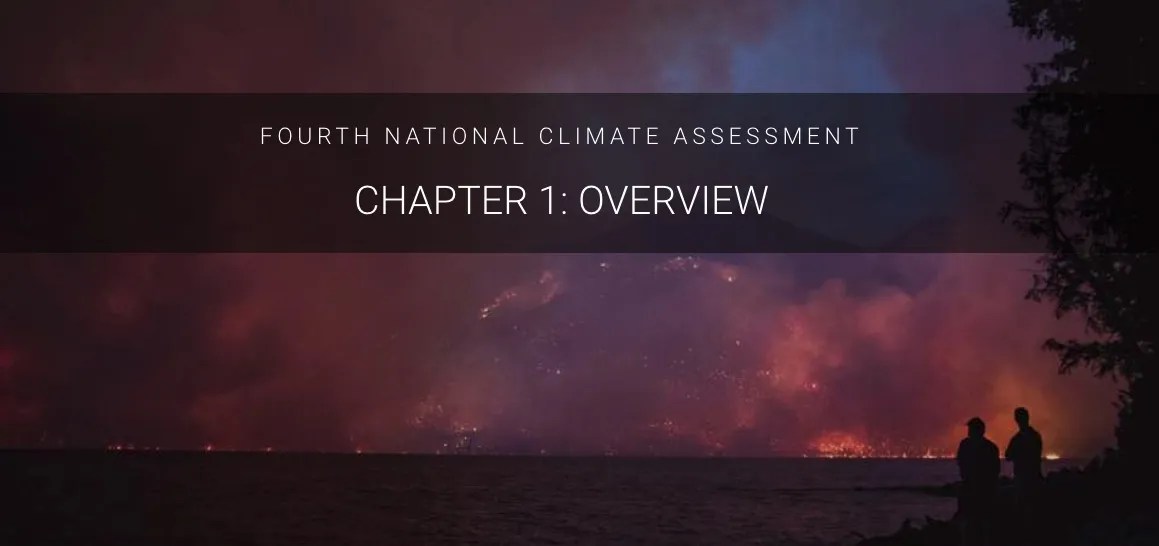
At 2 p.m. Friday on the day after Thanksgiving President Trump’s administration released an important document about our climate. Required every four years by a 1990 act of Congress, the Fourth National Climate Assessment focuses on the human welfare, societal, and environmental elements of climate change.
Surprising in its bluntness, it lays out the devastating effects on the economy, health, environment, and wildfires. Within the 1,656-page document wildfires are covered rather extensively and photos of fires are used several times in the headers of sections, like the one below for Chapter 1 (which may have been taken at the Howe Ridge Fire in Glacier National Park in Montana in August).
The scientists concluded that by the middle of this century, the annual area burned in the western United States could increase 2–6 times from the present, depending on the geographic area, ecosystem, and local climate. The area burned by lightning-ignited wildfires could increase 30 percent by 2060.
In the Southeast rising temperatures and increases in the duration and intensity of drought are expected to increase wildfire occurrence and also reduce the effectiveness of prescribed fire. Intra-annual droughts, like the one in 2016, are expected to become more frequent in the future. Thus, drought and greater fire activity are expected to continue to transform forest ecosystems in the region.
In the Southwest, recent wildfires have made California ecosystems and Southwest forests net carbon emitters (they are releasing more carbon to the atmosphere than they are storing). With continued greenhouse gas emissions, models project more wildfire across the area. Under higher emissions, fire frequency could increase 25%, and the frequency of very large fires (greater than 5,000 hectares) could triple.
The Northwest is likely to continue to warm during all seasons under all future scenarios, although the rate of warming depends on current and future emissions. The warming trend is projected to be accentuated in certain mountain areas in late winter and spring, further exacerbating snowpack loss and increasing the risk for insect infestations and wildfires. In central Idaho and eastern Oregon and Washington, vast mountain areas have already been transformed by mountain pine beetle infestations, wildfires, or both, but the western Cascades and coastal mountain ranges have less experience with these growing threats. Forests in the interior Northwest are changing rapidly because of increasing wildfire and insect and disease damage, attributed largely to a changing climate. These changes are expected to increase as temperatures increase and as summer droughts deepen.
Below are wildfire-related excerpts from the report.
Chapter 1: Overview
The impacts of climate change and extreme weather on natural and built systems are often considered from the perspective of individual sectors: how does a changing climate impact water resources, the electric grid, or the food system? None of these sectors, however, exists in isolation. The natural, built, and social systems we rely on are all interconnected, and impacts and management choices within one sector may have cascading effects on the others.